International Journal of Innovative Research in Science, Engineering and Technology
ISSN ONLINE(2319-8753)PRINT(2347-6710)
ISSN ONLINE(2319-8753)PRINT(2347-6710)
| Dhanasingaraja R, Kalaimagal S, Muralidharan G Division of Mechatronics, Madras Institute of Technology, Anna University, Chennai, India. |
| Related article at Pubmed, Scholar Google |
Visit for more related articles at International Journal of Innovative Research in Science, Engineering and Technology
Autonomous vehicle navigation gains increasing importance in various growing application areas. In this paper we described a system it navigates the vehicle autonomously to its destination. This system provides a communication between vehicle and internet using GPRS modem. This system interfaced with OSRM open source map through internet. So we can decide the robot path from internet. In non-urban Domains such as deserts the problem of successful GPS-based navigation appears to be almost solved, navigation in urban domains particularly in the close vicinity of buildings is still a challenging problem. In such situations GPS accuracy significantly drops down due to unavailability of GPS signal. This project also improves the efficiency in navigation. This system not only relay on GPS. To improve the efficiency it uses location information from inertial sensors also. This system uses rotatable laser range finder for obstacle sensing. This is also designed in such a way that It can be monitored from anywhere through internet.
Keywords |
| GPS, GPRS, compass, navigation, localization, inertial, laser |
INTRODUCTION |
| An autonomous vehicle, also known as a driverless vehicle, self-driving vehicle is an vehicle capable of fulfilling the human transportation capabilities of a traditional vehicle. As an autonomous vehicle, it is capable of sensing its environment and navigating without human input. |
| Autonomous vehicles sense their surroundings with such techniques as radar, lidar, GPS, and computer vision. Advanced control systems interpret sensory information to identify appropriate navigation paths, as well as obstacles and relevant signage. Some autonomous vehicles update their maps based on sensory input, allowing the vehicles to keep track of their position even when conditions change or when they enter uncharted environments. For any mobile robot, the ability to Navigate in its environment is one of the most important capabilities. In general, the navigation task can be defined as the combination of three basic competences: localization, path planning and vehicle control. Localization denotes the robotâÂÂs ability to determine its own position and orientation (pose) within a global reference frame. Path planning defines the computation of an adequate sequence of motion commands to reach the desired destination from the current robot position. Due to its planning component, path planning is typically done before motion. The planned path is followed by the robot using feedback control. This controller includes reactive obstacle avoidance as well as global path preplanning. |
| The potential application areas of the autonomous navigation of mobile robots include automatic driving, guidance for the blind and disabled, exploration of Dangerous regions, transporting objects in factory or office environments, collecting geographical information in unknown terrains like unmanned exploration of a new planetary surface, etc. |
II. ME THODOLOGY |
| This system takes the current position as source and gets the destination point from user. User has to specify the destination in the map. System finds the shortest path to the destination and extracts the lat, long coordinates from the graph & sends to the vehicle. Vehicle follows the coordinate using GPS and compass. If GPS signal not received, inertial navigation system is used to obtain current coordinate. |
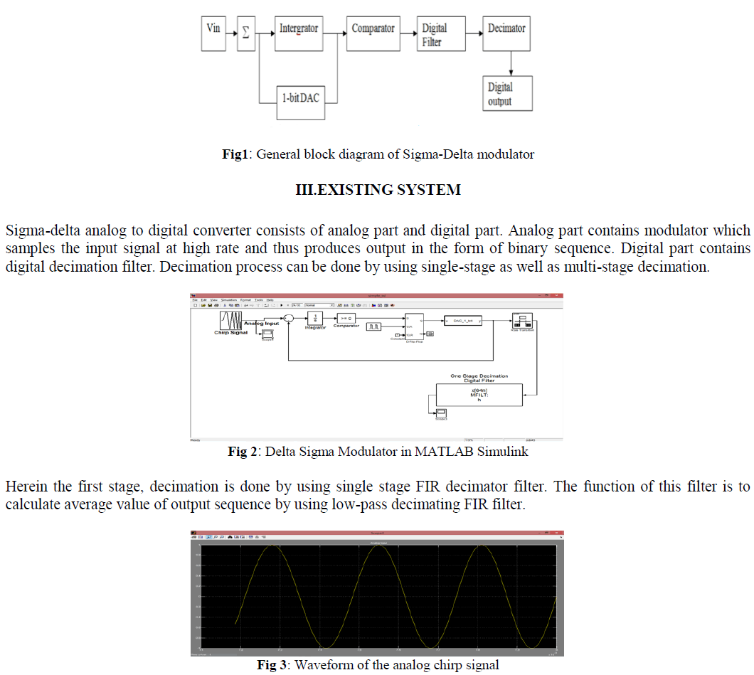
| Obstacles around the vehicle are sensed by laser range finder. Current location of the vehicle is uploaded to the server through GPRS. At the server, coordinates are obtained and displayed in the Google map for monitoring purpose. So the vehicle can be monitored from anywhere in the world. Block diagram of the vehicle is show in figure 1. |
 |
A.WAYPOINTS EXTRACTION |
| This paper uses the appliance of standardized geodata from the OpenStreetMap project as an Environmental representation for autonomous robot navigation. Founded in July 2004, OpenStreetMap (OSM) is a collaborative project which aims to create a free to use and editable map of the world. Different from commercial map distributors like Google, Navteq and Teleatlas, the OSM map is public domain and created by volunteers performing systematic ground surveys with a handheld GPS receiver. |
 |
| OSM map allows the user to select the vehicleâÂÂs navigation path. Waypoints along the path are extracted and send to the vehicle through internet. |
 |
| A visual basic application is designed to perform this task. |
B.PERCEPTION |
| The perception system is responsible for providing a model of the world to the behavioral and motion planning subsystems. The model includes the moving vehicles and static obstacles and localizing the vehicle relative to, and estimating the shape of, the roads it is driving on. A rotatable laser range finder is used to sense the obstacles around the vehicle. |
C.LOCALIZATION |
| Localization is the problem of estimating robot's pose relative to its environment from sensor observations. Localization is a necessity for successful mobile robot systems, it has been referred to as "the most fundamental problem to providing a mobile robot with autonomous capabilities”. To achieve autonomous navigation, the robot must maintain an accurate knowledge of its position and orientation. Successful achievement of all other navigation tasks depends on the robot ability to know its position and orientation accurately. This system uses GPS and inertial sensors for localization. |
| A GPS receiver calculates its position by precisely Timing the signals sent by GPS satellites high above the Earth. Each satellite continually transmits messages that include |
| 1. The time the message was transmitted |
| 2. Satellite position at time of message transmission |
| The receiver uses the messages it receives to determine the transit time of each message and computes the distance to each satellite using the speed of light. Each of these distances and satellites' locations define a sphere. The receiver is on the surface of each of these spheres when the distances and the satellites' locations are correct. These distances and satellites' locations are used to compute the location of the receiver using the navigation equations. This location is then displayed, perhaps with a moving map display or latitude and longitude; elevation information may be included. Many GPS units show derived information such as direction and speed, calculated from position changes. |
| GPS receivers also work on these NMEA Standards. Every sentence begins with a „$â sign, has about 80 characters and ends up with a carriage return/line feed. |
| Sentences are mostly framed in single lines (may run over to multiple lines sometimes) and the data items in each sentence are separated by commas. |
| The data received is just ASCII text and varies in precision. A sentence ends with checksum which consists of a „*â and two hexadecimal digits. The checksum digits represent an 8 bit exclusive OR of all the characters between, but not including, the $ and *. |
| Latitude, longitude and number of satellites in view is extracted from the GPS data. Accuracy of the information depends on number of satellites in view. If the data is not accurate, localization is obtained from inertial sensors. Inertial localization works by keeping the track of positions vehicles moved. It uses wheel encoder and compass for sensing robot movements. |
D.NAVIGATION |
| Algorithm for navigation of autonomous robot is shown in the figure 6. This system gets the current position from GPS and destination coordinate from user. It finds the shortest path between current position and destination. Then travels through the shortest path. If it senses any obstacles in the path it selects the new path based on the next shortest path. This process is continued until the destination is reached. If the destination is reached vehicle gets stopped. At the same time system sends itâÂÂs current position coordinates to monitoring part. |
 |
E.MAPPING |
| The system allows a user to view the present and the past positions recorded of a target object on Google Map through the internet. The system reads the current position of the object using GPS, the data is sent via GPRS service from the GSM network towards a web server using the POST method of the HTTP protocol. |
 |
| The objectâÂÂs position data is then stored in the database for live and past tracking. A web application is developed using PHP, JavaScript, Ajax and MySQL with the Google Map embedded.Third party server cosm pachube was used for this system. |
III. EXPERIME NTAL SETUP |
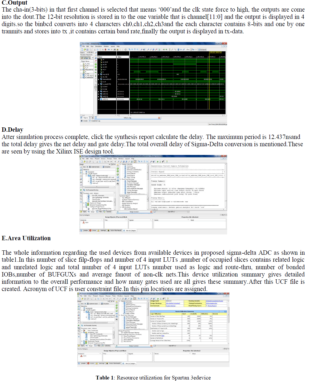
| Figure.7 shows the structure of the mobile robot truck model. The vehicle model used in this work is in dimension of 48 cm in length, 30 cm in width and 30 cm in height. |
 |
| It consists of LPC2148 ARM7 processor, GPS receiver, GSM/GPRS modem, laser sensor in front and the circuitry. This vehicle uses 4 DC motors with 20RPM and 8KgCm Torque, Relay, MAX232ACPE and L293D. This model uses 7805 as a Voltage regulator which provides a convenient power source for most TTL components. Output signal from GPS receiver and GSM Modem is RS-232 signal that can be changed to TTL signal by using MAX232.L293d is a dual H-Bridge motor driver, so with one IC interface two DC motors can be interfaced. These motors can be controlled in both clockwise and counter clockwise-direction. |
IV. CONCLUSION |
| The overall goal of this work is to navigate the vehicle autonomously to its destination. When IMU is added with GPS it improves the accuracy in localization. The designed vehicle successfully interfaced with open source OSRM map through GPRS. This makes easy for the user to feed path to the robot. This saves the time by avoiding manual collection of waypoints along path as in conventional systems. |
References |
|