International Journal of Innovative Research in Science, Engineering and Technology
ISSN ONLINE(2319-8753)PRINT(2347-6710)
ISSN ONLINE(2319-8753)PRINT(2347-6710)
Abel Ojo Talabi1, Ayodeji Kayode Ogundana2
|
| Related article at Pubmed, Scholar Google |
Visit for more related articles at International Journal of Innovative Research in Science, Engineering and Technology
Field measurements are readily available/reliable (carried out on fresh/uncontaminated samples), easy to measure and relatively inexpensive. This study aimed at groundwater potential and quality assessments in Ijero-Ekiti using in-situ parameters (static water level, water depth, temperature, pH, and electrical conductivity (EC)). Geographical locations of samples were measured using Devgru Dummy Garmin GPS. In addition, static water level and depth of wells were measured using dip meter while temperature, pH and EC were measured employing a Multiparameter TestrTm 35 series Meter. Elevation measurements (465.77 – 546.25m) revealed that the study area was of rugged topography and varied erosion surfaces. EC values were <1000μS/cm (av 517.83μS/cm) and pH ranged from 7.4–9.5 mg/L (av 8.42) indicating alkaline water. The temperature of sampled groundwater in the area was fairly uniform with an average value of 27.67ËC. Groundwater in Ijero-Ekiti was assessed to be suitable for drinking and irrigation purposes based on EC values. However, the pH of some of the groundwater samples exceeded the WHO approved standard for drinking water warranting treatment of the groundwater before consumption. The average value of volume of water in the wells was 1.35m3. Groundwater potential using approximate volume of water in wells revealed that the wells in the pegmatite and calc-gneiss bedrocks have better potential compared to biotite-schist. However, with respect to quantity; the groundwater was grossly insufficient for irrigation. This research has provided a good preliminary check on groundwater potential and quality status of the study area.
Keywords |
| In-situ parameters, Static water level, Alkaline water, Groundwater potential. |
I. INTRODUCTION |
| Surface water availability in Ijero-Ekiti is scanty as there are no major rivers and the few available streams dry up during dry season. Consequently, groundwater serves as the main source of water supply for domestic and drinking purposes in the area. Groundwater chemistry depends on a number of factors, such as general geology, degree of chemical weathering of the various rock types, quality of recharge water and inputs from sources other than water-rock interaction. Such factors and their interactions result in a complex groundwater quality [1], [2]. Hydrogeochemical processes are responsible for the seasonal, temporal and spatial variations of groundwater chemistry and quality [3]. |
| There are several approaches to groundwater evaluation. [4], employed integrated remote sensing and GIS approach to assess the groundwater potential of Ekiti State Basement Complex terrain and categorized the area into very good, good-moderately good and poor zones. In addition, assessment of the groundwater potential involving the collection, interpretation and analyses of hydrogeomorphological, geologic/hydrogeologic data have been carried out in the Basement Complex terrain of Ekiti State [5]. Based on this research work, Ekiti Basement Complex terrain was characterized into five different groundwater potential zones which are very low, low, moderate, high and very high groundwater potential zones. [6] worked on the hydrochemical quality and stable isotope characterization of shallow groundwater system in Ekiti Basement terrain and concluded that groundwater occurrence in the area was recharged predominantly from meteoric (rainfall) source and that the groundwater was chemically potable. Analyses for many important physical, chemical and microbiological variables can be carried out in the field using apparatus made specifically for field use. Field measurements have some advantages; tests are carried out on fresh samples whose characteristics have not been contaminated or otherwise changed as a result of storage in a container, samples are highly unlikely to lose the labels that identify the time and place of sampling and field analysis may be the only feasible way to obtain reliable water quality information especially in situation where laboratory analysis are not reliable. This present study is based on some few field measurements to provide an insight to groundwater potential and quality in the area. |
II. RELATED WORK |
| Literature search revealed that some specific research works have been carried out in Ijero-Ekiti. The researches could be categorized into geophysical assessment of groundwater potential, geochemical assessments of stream sediment/mineral deposits and assessments of industrial mineral potential of the study area. [7] in his lecture on Framework for and opportunities for sustainable private sector participation in solid minerals development in Ekiti state indicated occurrence of lepidolite, tourmaline, clay, feldspar, kaoline and cassiterite at Ijero-Ekiti. [8], successfully employed VES to locate viable point for borehole sitting in the tantalite zone of the study area. In the research work of [9] on stream sediment geochemistry of Ara, Epe and Ijero Area showed that the study area was mineralized in phosphate minerals, probably monazite, turquoise or apatite; ferruginous minerals which could be hematite and manganese-bearing minerals such as manganite or mica rich manganese. [10], reported that Ara and Ijero clays were geochemically similar having SiO2, Al2O3, Fe2O3 concentrations, which reflect derivation from the underlying basement rocks. Their research concluded that the clay deposits were suitable for the manufacture of paints, ceramics, refractories, agro-chemical and pharmaceutical products. [11] worked on the characterization of dumpsite soil: case study of Ado – Ekiti and Ijero Ekiti, Nigeria. They concluded that the moderately high concentrations of heavy metal in dumpsites and presence of microbial organisms likely indicated that the environmental quality has been significantly affected. The work of [12] revealed that Industrial assessments of rocks in Ijero-Ekiti using evaluated physical properties (including specific gravity; compressive strength, water absorption capacity, pH and porosity) indicated that the gneisses, quartzite, epidiorite and granite of the area were suitable for construction purposes. [13] worked on Industrial Minerals Potentials of Ijero Pegmatite in Ekiti State, Southwestern Nigeria and reported that industrial minerals found in Ijero-Ekiti include feldspar, sheet mica, tantalum-niobium, lithium minerals and gemstones while the granite that intruded into the hoist rocks was rich in garnets. [14] worked on characterization of vitrified porcelain tiles using feldspar from three selected deposits in Nigeria, of which Ijero was one. All the three feldspar deposits were found to be suitable for producing vitrified porcelain tiles. The researchers from literature hardly work on in-situ parameters for potential and quality characterization of groundwater in the study area. Hence, the focus of this study is to carry out a preliminary quality and potential assessment of groundwater in the Basement Complex terrain of Ijero- Ekiti, Southwestern Nigeria. |
III. LOCATION AND GEOLOGY |
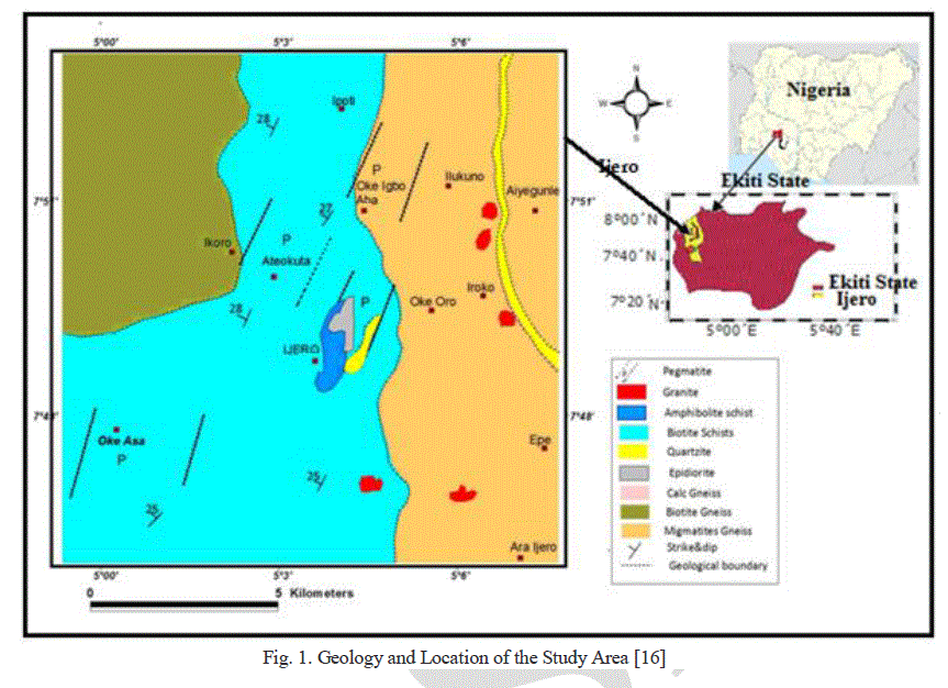
| Ijero-Ekiti (the study area) is the second largest town in the whole of Ekiti State with population of 221,405 as reflected in [15]. The area is the economic nerve centre of Ekiti State being largely an agrarian population producing cash crops and food crops. Ijero-Ekiti is also the seat of mineral resources such as tourmaline, feldspar and crystal stone.Fig.1shows the location and geology of the study area. The study area lies between longitudes 5o00´E and 5o09´E, and latitudes 7o48´N and 7o51´N. It is bordered by Moba Local Government in the north, Ido Osi Local Government, Irepodun/Ifelodun Local Government in the east, Ekiti West in the south and Ila Orangun in Osun State in the West and Northwest. |
| Geologically, the area falls within the Basement Complex of Southwestern Nigeria with the following major lithological units; biotite-schist, pegmatite, calc-gneiss and quartzite. The biotite-schist is mainly located in the central portion of the area with granite and coarse grained pegmatite intrusions exposed in places due to prolonged erosion. The calc-gneiss and quartzite occurs in the NE-SW trend within the study area (Fig. 1). |
 |
IV. METHODOLOGY |
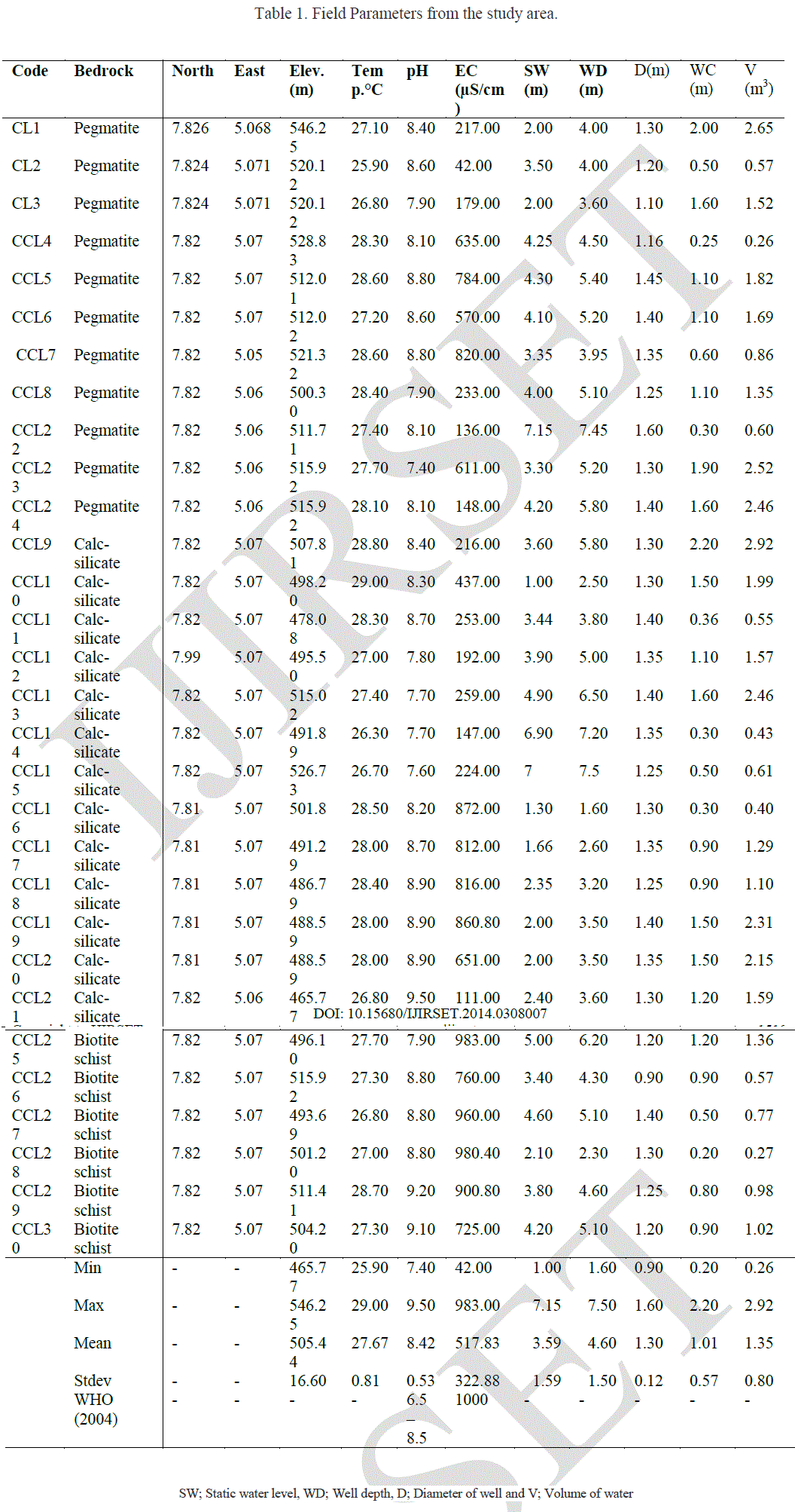
| All parameters involved in this research were measured in-situ. Thirty sampling locations were selected based on the spread of bedrocks in the area with 11 samples from pegmatite, 13 samples from calc-gneiss and 6 samples from biotite schist. At each location; geographical locations of samples were measured using Devgru Dummy Garmin GPS while temperature (ÃÂC), pH and EC (μS/cm) were measured using Multi-parameter TestrTm 35 series Meter. In addition, static water levels, depth of well were also measured using dip meter while the diameter of each well was measured using tape rule. Volume of water in each well was estimated employing the formula; |
| V = Πr2h (1) |
| where Π = 3.14, r = approximate radius of well and h = water column. |
| The water column was obtained by subtracting static water level from the depth of well (Depth of well – Static water level). Data obtained from the various measurements were subjected to statistical evaluation employing SPSS 17. |
V. RESULTS AND DISCUSSION |
| Result of the measured in-situ parameters in this research is presented in Table 1. The result revealed elevation ranging from 465.77 – 546.25m with standard deviation of 16.60m indicating rugged topography with varied erosion surfaces. Surface runoff was high in view of the topography and this could affect groundwater potential substantially. Fig. 2a represents bar chart of average elevation versus rock units of the area. The figure indicates that wells in the pegmatite bedrocks had the highest mean elevation (520m), followed by the biotite-schist while those on calc gneiss had the least average value. The temperature of sampled groundwater in the area was fairly uniform with an average value of 27.67. Fig.2b represents the plot of average temperature vs. rock units with calc-gneiss having the highest mean temperature. The pH of the groundwater ranged between 7.4 and 9.5 indicating alkaline water. |
 |
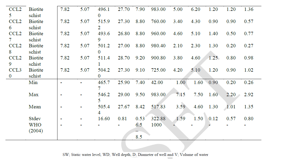 |
| In general about 50% of the groundwater has pH values above [17] approved standard for drinking water with all the sampled water from biotite-schist, four out of eleven samples of pegmatite and six out of thirteen samples of calcgneiss in this category. The variability of pH in the bedrocks is as a result of differences in their mineralogical composition as well as differential weathering intensity of the bedrock. Fig.2C which represents average pH vs. rock units in the study area shows that wells on biotite-schist are more alkaline than the other rock units. |
 |
 |
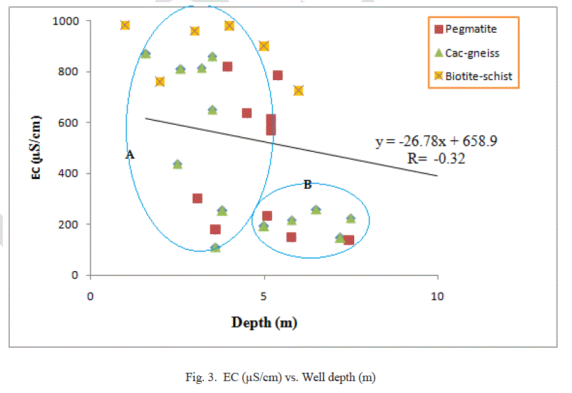
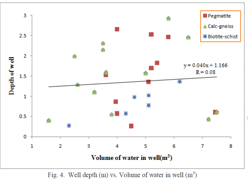
| The electrical conductivity (ECμS/cm) of groundwater in the study area was less than 1000μS/cm. The groundwater was classified as freshwater based on water classification by [19]. However, as indicated in Fig.2d, the order of average EC values in the bedrocks reflected that EC in biotite-schist>EC in calc gneiss>EC in pegmatite indicating indirectly the quality of groundwater in the bedrocks. In addition, [20] classified EC as low enrichment of salts (EC<1,500 μS/cm; medium enrichment of salts if EC is between 1,500 and 3,000 μS/cm; and high enrichment of salts if EC>3,000μS/cm. The well water samples in the study area fell under low enrichment of salts based on the measured EC. Thus, the EC values reflected groundwater that was low mineralized and with low residence time. The EC of water is an indicator of salinity and hazard as it gives the total salt concentration in water [21]. In this study, all sampled groundwater have EC values that were within the approved permissible limit [18]. Groundwater in the area was suitable for irrigation based on EC values as there was no harmful effect by salt concentration or salinity hazards with respect to EC. A plot of EC vs. Well depth as shown in Fig.3 revealed an inverse relationship i.e. EC decreased with increase in depth. However, a close look at the diagram showed that at depth <5m, barring few samples EC values were erratic but with most samples having high values while at depth>5m, EC values reduced i.e. EC≤ 200μS/cm. Thus weathering and solute dissolution was high at low depth while it decreased with increased depth. Furthermore, the static water levels and depth of wells ranged from 1.0 – 7.15m and 6 – 7.5m respectively while the average value of volume of water in the wells was 1.35m3. Groundwater potential using approximate volume of water in wells revealed that the wells in the pegmatite and calcgneiss bedrocks have better potential compared to biotite-schist (Fig.2e). A plot of volume of water in wells vs. Depth as shown in Fig.4 that depth has no control on the volume of water in the wells (Fig.4). |
 |
 |
VI. CONCLUSION |
| The current research presented a preliminary quality and potential assessment of Groundwater in the Basement Complex terrain of Ijero-Ekiti using insitu-parameters. The EC values reflected groundwater that was low mineralized and with low residence time, hence the groundwater was potable and suitable for irrigation except in some locations where the pH values exceeded [17] approved standard for drinking water warranting treatment before consumption. EC values decreased with depth while weathering and solute dissolution was high at low depth but decreased with increased depth. |
VII. ACKNOWLEDGEMENT |
| The authors are grateful to the final year students who participated in the field work operations of this research. |
References |
|