International Journal of Innovative Research in Science, Engineering and Technology
ISSN ONLINE(2319-8753)PRINT(2347-6710)
ISSN ONLINE(2319-8753)PRINT(2347-6710)
Xuan-Trung Nguyen1 and Sang-Il Lee2
|
| Related article at Pubmed, Scholar Google |
Visit for more related articles at International Journal of Innovative Research in Science, Engineering and Technology
Climate change (CC) has negative effects such as higher frequencies of stronger storms, floods, or droughts. In addition, sea level rise (SLR) poses a major threat to the coastal areas. Nam Dinh Province, Vietnam is an important coastal province in many aspects, located in the extreme-east of the Red River Delta. Recent studies predict an increment of sea level by 9% in this area and it will cause enormous damages to land, properties and people living here. This work predicts the impact of CC and SLR on the floodplain of Nam Dinh Province. The CC & SLR scenarios (A2, B1 & B2) were adopted, and expected future floods were simulated. The maximum sea level rise (65cm for B1, 75cm for B2 and 100cm for A2) were applied to compute the water level change in the river system. The results predict that at least 14.9~17.4% of lands will be lost and farmers will be the most-affected victims.
Keywords |
| Sea level rise; Floodplain; Land loss; Nam Dinh Province; Red River Delta. |
I. INTRODUCTION |
| Vietnam is a tropical country suffering from many storms every year. From 1891 to 1990, there were 496 storms recorded that caused serious damages. According to National Center for Hydro-meteorological Forecast [1], storms in August 1996 destroyed the Gua River’s levee and this led to the swamping of many communities, and 61 persons were recorded as either dead or missing. According to summary from Central Committee for Flood and Storm Control [2], economic losses from natural disasters in 1999 amounted to about 387.7 million USD and the total area of rice fields submerged was 131,267 ha. This study focuses on Nam Dinh Province located in the extreme-east of Red River Delta, which is predicted to be seriously affected by CC and SLR [3, 4, 5]. |
| The objective of this study is to estimate the impact of CC and SLR on Nam Dinh Province. Special attention is given to the fate of agricultural areas. Numerical modelling and geographic information system (GIS) are used to compute and delineate the extent of affected floodplain and land loss. The results from this study could be a reference to policy makers when they develop provincial strategies and plans to cope with future environmental changes. The following is what we describe in this work: |
| How to develop scenarios for CC, SLR and flood. |
| How to predict maximum water surface elevation in river channels. |
| How to use HEC-RAS model and ArcGis to compute and to display the floodplain |
| How to estimate damages to be done on the agricultural lands of Nam Dinh area. |
II. MATERIALS AND METHODS |
| A. Study Site |
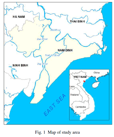
| Nam Dinh Province is in the extreme-east of the Bac Bo plain with the area of 1638.07 km2 and the coastal line of 72 km. There are three great estuaries in this area: Ba Lat of the Red, Lach Giang of the Ninh Co and Day of the Day rivers (see Fig. 1). Population of Nam Dinh Province is about 1,850,000. The topography is relatively flat, gradually inclining to the sea. The area belongs to the tropical monsoon zone with two completely different seasons: The rainy season between May and September, is hot with much rain; the dry season from October to April is cool and less wet. The annual rainfall in Nam Dinh region is within the range of 1,435-1,197 mm. |
| The drainage network of Nam Dinh Province is dense: it includes the Red River consisting of the Red, the Dao and Ninh Co rivers, and the Day River system. The Red River forms the natural boundary between Nam Dinh and Thai Binh Provinces and discharges into the sea at Ba Lat estuary. From Nam Dinh City to the sea, the Red River channel has an average width of between 500–600 m. Due to the even nature of the region’s topography, the Red River has a relatively low stream velocity. |
 |
| Agriculture in Nam Dinh uses around 66% of the province's land area (149,000 ha as of 2010). Therefore, it accounts for the main economic activity of Nam Dinh. The most important crops include rice, soybean, corn, peanut, and sweet potato, in addition to a large variety of tropical fruits and vegetables. Generally, rice paddy quota is thoroughly utilized. The irrigated lands can give high yield: There can be a rotation of about 2-3 harvests in a year. |
| Aquaculture sector area holds approximately 19,000 hectares, producing freshwater and saltwater goods. Forestry in Nam Dinh accounts for around 5,000 ha (3% of total area). Mangroves and permanent crops are the main plants, and they grow mainly along the shorelines. Their main role in Nam Dinh is coastal protection. |
| B. Data & Scenarios |
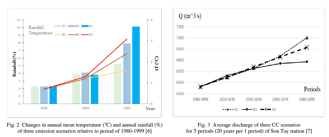
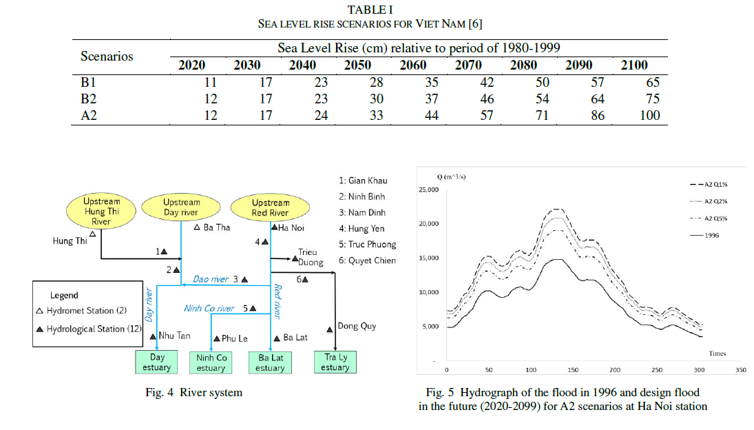
| Land use, hydro-meteorological, CC & SLR data for this study were collected or generated from different sources: Land use map was provided by Nam Dinh Environmental and Natural Resources Department. The runoff data, meteorological data and cross sections were obtained from Hydrometeorological Data Center of Vietnam. Daily data for 1972, 1973, 1977 and 1990-2000 and hourly data for 1996, 2000 and 2004 were included. The CC & SLR data were developed by MONRE [6], which included daily data of precipitation, evaporation, temperature and sea level for three scenarios B1, B2, A2 (see Fig. 2, Fig. 3, Table I). The maximum daily runoff per year from 2020–2099 at Son Tay station were provided by IMHEN [7]. |
| The observation stations are shown in Fig. 4. Upstream boundaries at Hung Thi River and Day River were generated from HEC-HMS model. Flood scenarios at Ha Noi (see Fig. 5) were developed base on flood frequency curves at Ha Noi station and the relationship between elevations of Son Tay & Ha Noi stations. |
| C. Procedure for Analysis |
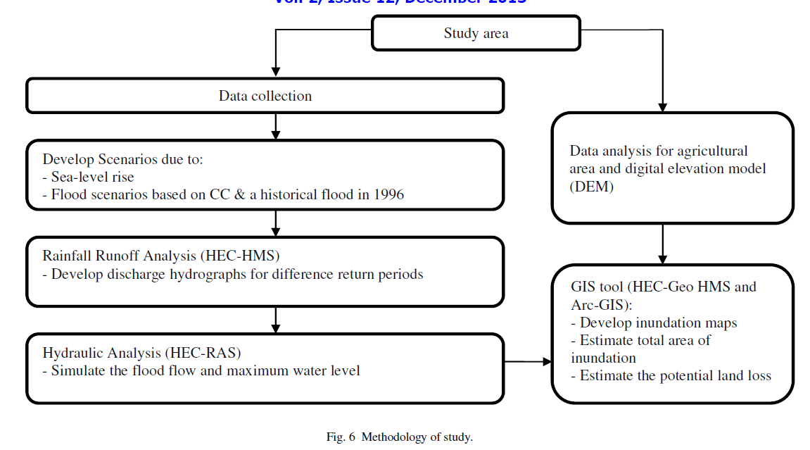
| Work flow for the hydrologic and hydraulic analysis is shown in Fig. 6. Once scenarios for CC and SLR along with the past flood history are ready, rainfall-runoff analysis is conducted using a hydrologic simulation model HEC-HMS. Discharge hydrographs are produced for various return periods. They can serve as inputs to hydraulic analysis for computing flood flow and water levels in the river channel. |
| HEC-RAS, an integrated system of software that allows the simulation of one-dimensional river hydraulics calculations, was used for hydraulic analysis. The HEC-RAS system contains three components for: (1) steady flow water surface profile computations; (2) unsteady flow simulation; and (3) movable boundary sediment transport computations. A key element is that all three components use a common geometric data representation and hydraulic computation routines. |
| In addition, the system contains several hydraulic design features that can be invoked once the basic water surface profiles are computed. Results of the analysis are fed to GIS software which can help the users generate inundation maps or conduct flood-related estimations. |
 |
 |
 |
III. CALIBRATION AND VALIDATION |
| Model was calibrated using the measured hourly runoff data. The difference between the average simulated and observed runoff is tested by Nash-Sutcliffe criterion: |
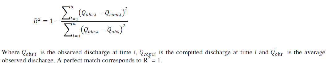 |
| The calibrated model performed well against the validation data. Fig. 7 depicts observed and computed data at Nam Dinh (34 km from coastline and Truc Phuong station 19 km from the coastline). The different between measured and simulated runoff during the validation period was small: the Nash-Sutcliffe criterion were above 95% for all six stations (Table II). |
IV. RESULTS |
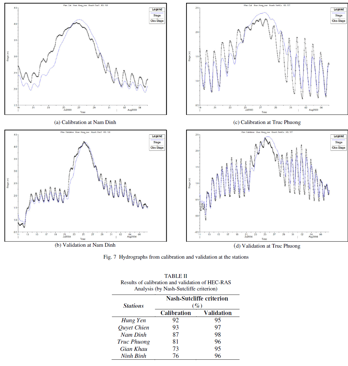
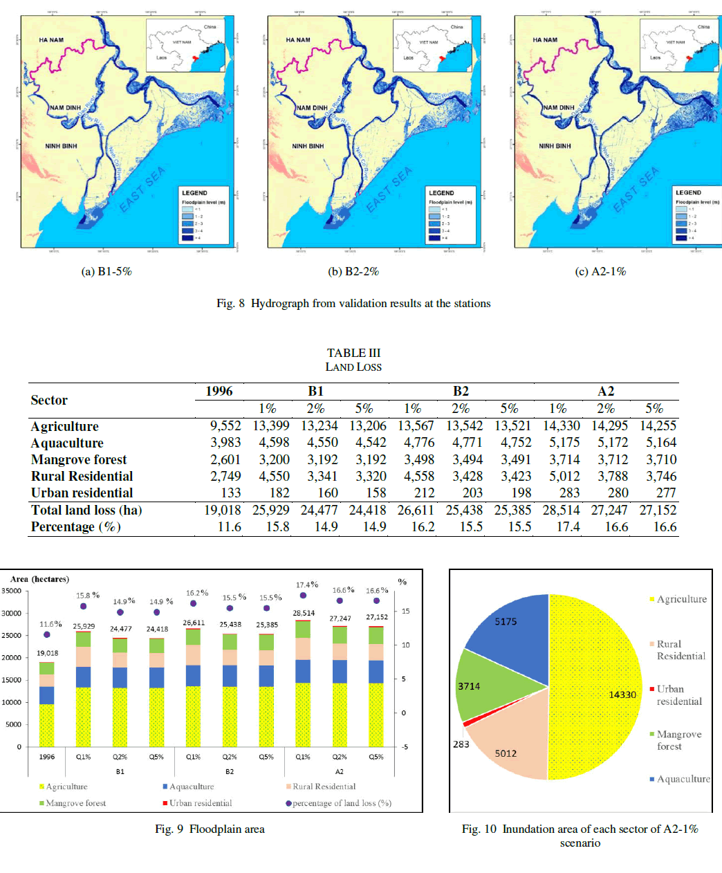
| According to the analysis of the impact of CC & SLR, the total inundation area turned out to be about 24,418~28,514 ha out of total area 163,807 ha of Nam Dinh Province (See Fig. 8 and Table III). Compare this value with 19,018 ha of the 1996 flood event. Results from all scenarios show that more than 50% of inundated area will be agricultural land; inundation areas in aquaculture, mangrove forest and rural residential account for no more than 15%, respectively (Fig. 9 and 10). Especially, the damage from agricultural activity would be significant due to the inundation area increase by 3,847~4,778 ha. |
| As for the land loss, the scenario B1-5% has the smallest effect on inundation (24,418 ha, approximately 14.9% area of the province), while scenario A2-1% leads to the largest inundation area (28,514 ha, approximately 17.4% of total province area). |
 |
 |
V. CONCLUSION |
| It is expected that CC and SLR would influence Nam Dinh Province, Vietnam in many critical aspects. The change of rainfall and temperature will bring about the increment of strength in flood. In addition, the rise of the sea level coupled with heavier than usual precipitation may increase the risk of flooding. Analysis predicts that at least 14.9~17.4% of lands in Nam Dihn Province will be lost from inundation. |
| Among others, farmers will be the most-affected victims to the impacts of CC & SLR. The damages to the rural residential and agricultural land could reach about 20,000 ha, which is approximately two times larger than the damages experienced in the 1996 flood disaster. Also, combination of CC and SLR would submerge more than 3,000 ha mangrove and coastal protection forest, which could have a major influence on mangrove ecosystem. The actual extent, however, will depend on the actual progress of the sea level rise, sediment supply and the topography of the coastline. |
| Under the combined effects of CC & SLR, the floodplain area will increase significantly. In particular, SLR could submerge the low lands near the coastal line permanently. The water quality in the area would be worsened. Therefore, planning for the development of Nam Dinh Province should take into account the impact of CC & SLR as an important factor. |
ACKNOWLEDGMENT |
| This research was supported by the National Research Foundation of Korea (NRF) (grant number 2013-052502). |
References |
|