International Journal of Innovative Research in Science, Engineering and Technology
ISSN ONLINE(2319-8753)PRINT(2347-6710)
ISSN ONLINE(2319-8753)PRINT(2347-6710)
M.L.Waikar1 and Aditya P. Nilawar2
|
| Related article at Pubmed, Scholar Google |
Visit for more related articles at International Journal of Innovative Research in Science, Engineering and Technology
Groundwater is an important resource contributing significantly in total annual supply. However, overexploitation has depleted groundwater availability considerably and also led to land subsidence at some places. Assessing the potential zone of groundwater recharge is extremely important for the protection of water quality and the management of groundwater systems. Groundwater potential zones are demarked with the help of remote sensing and Geographic Information System (GIS) techniques. In this study a standard methodology is proposed to determine groundwater potential using integration of RS & GIS technique. The composite map is generated using GIS tools. The accurate information to obtain the parameters that can be considered for identifying the groundwater potential zone such as geology, slope, drainage density, geomorphic units and lineament density are generated using the satellite data and survey of India (SOI) toposheets of scale 1:50000. It is then integrated with weighted overlay in ArcGIS. Suitable ranks are assigned for each category of these parameters. For the various geomorphic units, weight factors are decided based on their capability to store groundwater. This procedure is repeated for all the other layers and resultant layers are reclassified. The groundwater potential zones are classified into five categories like very poor, poor, moderate, good & excellent. The use of suggested methodology is demonstrated for a selected study area in Parbhani district of Maharashtra. This groundwater potential information will be useful for effective identification of suitable locations for extraction of water.
Keywords |
| Remote sensing, GIS, Weighted overlay, Thematic maps. |
INTRODUCTION |
| Groundwater is one of the most valuable natural resources, which supports human health, economic development and ecological diversity. Because of its several inherent qualities it has become an immensely important and dependable source of water supplies in all climatic regions including both urban and rural areas of developed and developing countries. Groundwater is a form of water occupying all the voids within a geological stratum. Water bearing formations of the earth’s crust act as conduits for transmission and as reservoirs for storing water. The groundwater occurrence in a geological formation and the scope for its exploitation primarily depends on the formation of porosity. High relief and steep slopes impart higher runoff, while topographical depressions increase infiltration. An area of high drainage density also increases surface runoff compared to a low drainage density area. Surface water bodies like rivers, ponds, etc., can act as recharge zones (Murugesan B. et al., 2012). |
| Over the years the growing importance of groundwater based on an increasing need has led to unscientific exploitation of groundwater creating a water stress condition. This alarming situation calls for a cost and time effective technique for proper evaluation of groundwater resources and management planning. A groundwater developing program requires a large volume of data from various sources. Hence, identification and quantization of these features are important for generating a groundwater potential model of a study area. Currently groundwater is gaining more attention due to drought problem, rural water supply, irrigation project and low cost of development it requires. Despite the extensive research and technological advancement, the study of groundwater has remained more risky, as there is no direct method to facilitate observation of water below the surface. Its presence or absence can only be inferred indirectly by studying the geological and surface parameters. The different hydrogeological themes can be used to identify the groundwater potential zone of the present area. The remote sensing and Geographic information system (GIS) tool can open new path in water resource studies. Analysis of remote sensing data along the survey of India (SOI) topographical sheets and collateral information with necessary ground truth verifications help in generating the baseline informat ion for groundwater targeting. Identification of groundwater occurrence location using remote sensing data is based on indirect analysis of directly observable terrain features like geological structures, geomorphology, and their hydrologic characteristics. Also lineaments play significant role in groundwater exploration in all type of terrain. Application of GIS and RS can also be considered for multi criteria analysis in resource evaluation and hydrogeomorphological mapping for water resource management. The use of remote sensing and GIS tools to extract detailed drainage, slope and geomorphic features in parts of Parbhani District suggests appropriate methods for groundwater potential zone studies. |
RELATED WORK |
| Murugesan Bagyaraj et al., (2012) have carried out groundwater study in the Dindigul district of kodaikanal hill, which is a mountainous terrain in the Western Ghats of Tamilnadu. Ground water potential zones have been demarcated with the help of remote sensing and Geographical information (GIS) techniques. All thematic maps are generated using the resource sat (IRS P6 LISS IV MX) data and Inverse distance weight (IDW) model is used in GIS data to identify the groundwater potential of the study area. For the various geomorphic units, weight factors were assigned based on their capability to store groundwater. |
| Prabir Mukherjee et al., (2012) made an attempt to determine the groundwater potential zones within an arid region of Kachchh district, Gujarat. Thematic layers have been generated by using ancillary data and digital satellite image. The potential zones have been obtained by weighted overlay analysis, the ranking given for each individual parameter of each thematic map and weights were assigned according to their influence. |
| Deepesh Machiwal et al., (2010) proposed a standard methodology to delineate groundwater potential zones using integrated RS, GIS and multi-criteria decision making (MCDM) techniques. The methodology is demonstrated by a case study in Udaipur district of Rajasthan, western India. Initially, ten thematic layers have been considered. Weights of the thematic layers and their features then normalized by using AHP (analytic hierarchy process) MCDM technique and eigenvector method. Finally, the selected thematic maps were integrated by weighted linear combination method in a GIS environment to generate a groundwater potential map. |
| Cheng-Haw Lee et al., (2008) proposed that assessing the potential zone of groundwater recharge is extremely important for the protection of water quality and the management of groundwater systems. Further groundwater potential study was carried out in Taiwan with the help of remote sensing and the geographical information system (GIS) by integrating the five contributing factors: lithology, land cover/land use, lineaments, drainage, and slope. The weights of factors contributing to the groundwater recharge are derived using aerial photos, geology maps, a land use database, and field verification. |
| Jobin Thomas et al., (2011) determined groundwater potential zone in tropical river basin (Kerala, India) using remote sensing and GIS techniques. The information on geology, geomorphology, lineaments, slope and land use/land cover was gathered from Landsat ETM + data and Survey of India (SOI) toposheets of scale 1:50,000 in addition, GIS platform was used for the integration of various themes. The composite map generated was further classified according to the spatial variation of the groundwater potential. The spatial variation of the potential indicates that groundwater occurrence is controlled by geology, structures, slope and landforms. |
OBJECTIVE & STUDY AREA |
1. General |
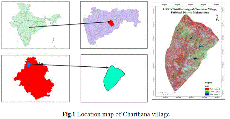
| The primary objective of the study is to contribute towards systematic groundwater studies utilizing Remote Sensing and Geographic Information Systems (GIS) in the delineation of groundwater potential areas. The present study area is located in the Parbhani district of Maharashtra which has natural boundaries of the Penganga river with a stretch of 160.93 km. (100 miles) in the north-east, and of the Godavari river with 64.37 km. (40 miles) in the southwest. Administratively, it is bounded on the north by Buldhana and Akola, on the east by Yeotmal and Nanded, on the south by Nanded and Bhir, and on the west by Aurangabad districts. The Godavari River, the Purna, the Dudhana, the Karpara River and their tributaries mainly drain the study area. The climate of the district is Semi arid, humid and subtropical. The average annual rainfall in the district is about 909 mm and temperature goes up to 42°C in summer and comes down to 11°C in winter season. Study area is Charthana, geographically located between 76° 30′, 76° 40′ E longitudes, and 19°30′, 19°45′ N latitudes. In the Survey of India toposheet, it forms part of 56 A/10 on 1:50000 scale. The northern and southern parts of the Parbhani district being hilly terrain are drought prone and faces the problem of acute water scarcity. On account of its hilly terrain these areas of the Parbhani district except for a few sources, faces shortage of drinking water. There is frequent drought problem in these regions. Although the area receives assured annual rainfall from 900-950 mm, most of it flows away as runoff without recharging the groundwater reservoir. |
 |
2. Geology |
| A large part of the district is occupied of rocks similar to the Deccan trap formation, (Fig.4) represented by of most horizontal lava flows of basaltic composition, thought to have been emplaced from fissures towards the close of the Mesozoic era, on to the lower tertiary era. These are referred to a Deccan traps owing to their prevalent occurrence in the Deccan, and the step like appearance of their exposures. They have a general tendency to form flat topped hills giving rise to plateaus, comprising several lava flows, each ranging from a few meters 10 to 50 meters in thickness. The various lithological units forming a flow may be differentiated from one another from their physical characteristics, such as their texture, jointing development, and mineralogical peculiarities. In general, the tops of these flows are characterized by the presence of a red ferruginous bed, which perhaps, represents an altered ferruginous upper crust of a flow. The traps in general exhibit typical spheroidal weathering, concentric layers simulating an onion being developed in weathered boulders. Some of these flows are characterized by the presence of a unit comprising well developed columnar joints giving pentagonal columns standing for several meters in height. The traps give rise to either deep brown to rich red or to black cotton soil. Such belt of soil is noticed around Parbhani, Lasina, Basmath, Kanhergaon, Gangakhed, Pathri, Partur, Jintur, Hingoli and Kalamnuri. The regur is rich in plant nutrients such as lime, magnesia, iron, variable amount of potash and low nitrogen and phosphorous. It is generally porous and swells considerably on addition of water and dries up with distinct cracks on losing the moisture. Another product of weathering is laterite which is occasionally noticed capping the high hills in the district. It is a porous, pitted, clayey rock with red, yellow, brown, grey mottled colors and with a thin limonitic coating on the surface. |
3. Groundwater |
| The hilly country receives the maximum rainfall. The groundwater is mostly tapped from percolation in wells and springs. The plains comprising the Penganga, Godavari, Kanad, Kapra and Dudhna river valleys, have sufficient water supply and may be said to be well-irrigated tracts of the district. Presence of flows and closely spaced system of joints in hard and massive basalts help the percolation of water and wells situated near either of these suitable conditions, have adequate water supply. |
4. Hydrogeology |
| In Deccan Basalt terrain groundwater occurs under phreatic conditions in the exposed lava flows and under semi confined conditions in the flows at deeper level. Lithological constraints dictate that groundwater is present in the pore spaces of the vesicular basalt and in the joint and fracture portions of massive parts of the flows. The primary porosity in the basalts is associated with the vesicles, which are the pore spaces developed due to the escape of volatile and gases when the lava erupts on the surface as a lava flow. This primary porosity in the basalt is naturally limited and related to the quantum of gasses/volatile in the eruptive phase, which resulted in the basalt flow. The groundwater in the study area therefore is restricted mostly to the zones of secondary porosity developed in these rocks due to fractures, joints and weathering. From the hydrogeological point of view, the frequency and extent of jointing, fracturing and the flow contacts and weathering along them are the most significant parameters imparting permeability and porosity for forming suitable groundwater reservoirs in the deccan basalt terrain. |
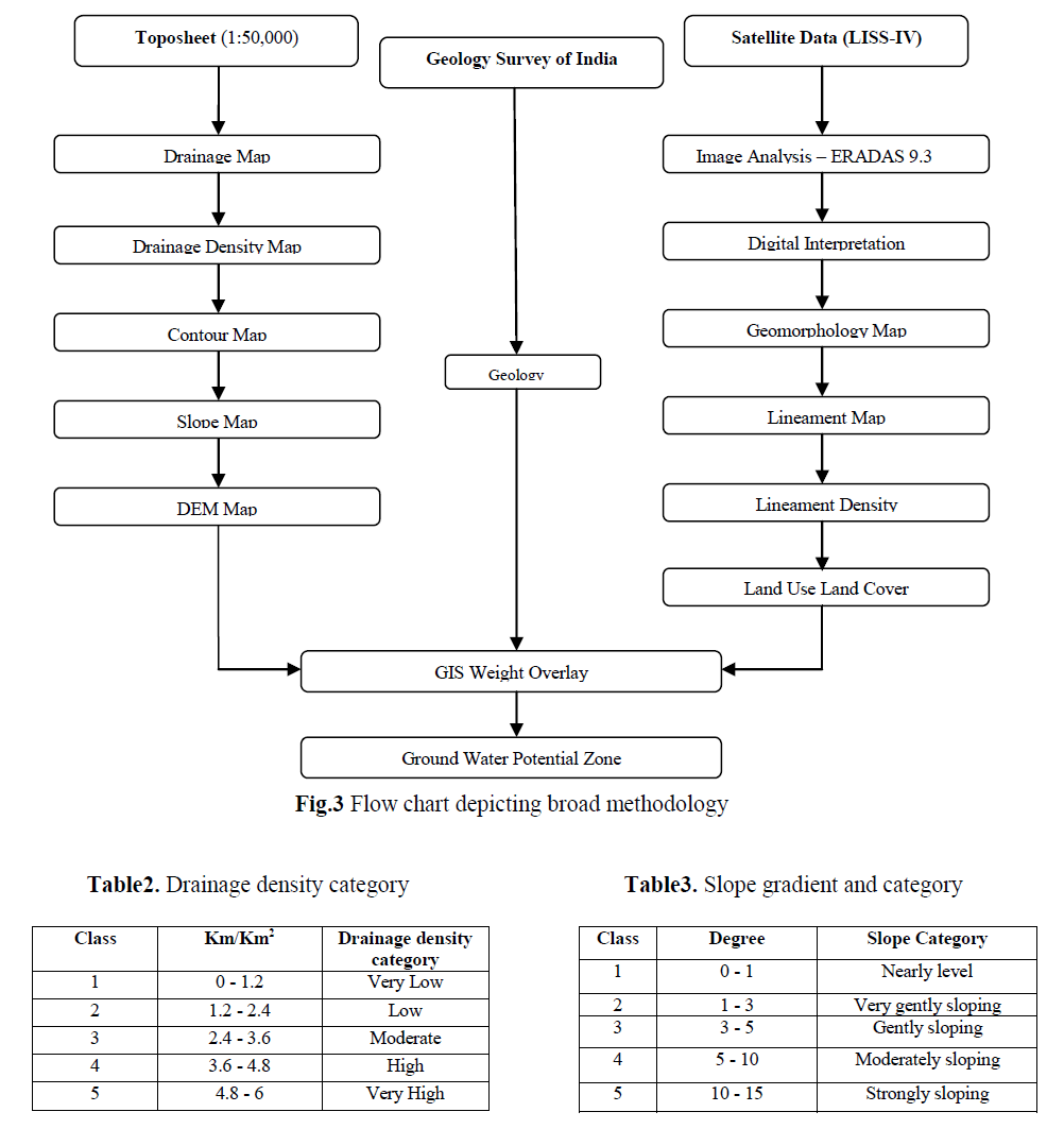
METHODOLOGY |
| The proposed methodology of study involved various activities such as base map preparation, LULC map preparation, Digitization and image processing using software and interpretation of the outputs. First stage includes development of spatial data base by using survey of India (SOI) toposheet on a 1: 50000 scale and IRS P6 LISS IV MX satellite data. GIS and remote sensing technology is applied to prepare various thematic maps with reference to groundwater like drainage density, contour, and stream length. Additionally, the Land Utilization Survey Database, geologic maps and on site investigation are adopted to quantitatively and qualitatively describe the hydro-geo- logical conditions of the area. |
| The second stage involved preparation of digital elevation model (DEM) by interpolating contour map that is digitized from SOI toposheet. DEM is used to prepare slope, aspect, flow accumulation and stream order. Methodology is widely used for preparing runoff potential map for small to medium size engaged drainage basin. |
| In the third stage, digital image processing of the satellite data is done for geo-referencing & geometric correction. This is followed by creation of different thematic layers using supervised classification technique. All the attributes from the collected data then summed to create the buffer map for agriculture area & settlement area. It is then followed by creation of other important data which is used to determine the ground water potential at the later stage like land use/land cover map, geological/lineament map, geo-morphological map and hydro-geo-morphological. |
| In the fourth stage all above themes are further processed and analysed in overlay and ranking is given to evaluate suitable groundwater potential zone. All the thematic layers will overlay by using GIS to find the final integrated output of groundwater potential zones in the present study, geomorphology, slope, drainage density, Land use and land cover, geology and lineament density are considered for the identification of groundwater potential. |
FACTORS INFLUENCING GROUNDWATER |
1. Drainage and drainage density map |
| A drainage basin is a natural unit draining runoff water to a common point. This map consists of water bodies, rivers, tributaries, perennial & ephemeral streams, ponds. The study area is fourth order basin joining the rivers, tributaries based on topography depicted in Fig.5. |
| Drainage network helps in delineation of watersheds. Drainage density and type of drainage gives information related to runoff, infiltration relief and permeability. Dendritic drainage indicates homogenous rocks, the trellis, rectangular and parallel drainage patterns indicate structural and lithological controls. The coarse drainage texture indicates highly porous and permeable rock formations; whereas fine drainage texture is more common in less pervious formations. Major faults, lineaments sometimes connects two or more drainage basins and act as conduits (Interconnecting channel ways). Flow of groundwater along these week zones is an established fact. Drainage pattern reflects surface characteristics as well as subsurface formation (Horton, 1945). |
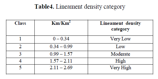
| Drainage density (in terms of Km/Km2) indicates closeness of spacing of channel as well as the nature of surface material, thus providing a quantitative measure of average length of stream channel for whole basin. It has been observed from drainage density measurement made over a wide range of geologic and climatic type that a low drainage density is more likely to occur in region and highly resistant of highly permeable subsoil material under dense vegetative cover and where relief is low. High drainage density is the resultant of weak or impermeable subsurface material, sparse vegetation and mountainous relief. Low drainage density leads to coarse drainage texture while high drainage density leads to fine drainage texture. The drainage density characterizes the runoff in an area or in other words, the quantum of relative rainwater that could have infiltrated. Hence the lesser the drainage density, the higher is the probability of recharge or potential groundwater zone. The entire drainage map is divided into five categories as in Table 2 and depicted in Fig.6 |
 |
2. Slope map |
| Slope is one of the important terrain parameters which are explained by horizontal spacing of the contours. In general, in the vector form closely spaced contours represent steeper slopes and sparse contours exhibit gentle slope whereas in the elevation output raster every cell has a slope value. Here, the lower slope values indicate the flatter terrain (gentle slope) and higher slope values correspond to steeper slope of the terrain. In the elevation raster, slope is measured by the identification of maximum rate of change in value from each cell to neighboring cells. The slope values are calculated either in percentage or degrees in both vector and raster forms, (Fig.7). The slope amount derived from digitized contours and spot heights have shown that elevation decreases from the northern part to the southern part with slope 0º to 10º in flat and mountainous areas respectively. In the nearly level slope area (0-1) degree, the surface runoff is slow allowing more time for rainwater to percolate and consider good groundwater potential zone, where as strong slope area (10-15) degree, facilitate high runoff allowing less residence time for rainwater hence comparatively less infiltration and poor groundwater potential. The entire slope map is divided into five categories as in Table 3. |
3. Lineament and Lineament density |
| Lineaments are straight linear elements visible at the Earth's surface as a significant “lines of landscape” (Hobbs, 1904). These are primarily a reflection of discontinuities on the Earth’s surface caused by geological or geomorphic processes (Clark & Wilson, 1994). Geological features that give rise to lineaments include faults, shear zones, fractures, dykes and veins as well as bedding planes and stratigraphic contacts. Geomorphic features, which appear as lineaments on the maps, aerial photographs and satellite images include streams, linear valleys and ridgelines. |
| Lineament studies have vast applications in different disciplines of geosciences for example identification of tectonic features, recognition of folds and faults, exploration of mineral deposits, petroleum prospects and groundwater etc. Remote sensing data i.e. satellite images of an area are useful to map lineaments. For better interpretation of lineaments, the images are digitally processed using image processing software. Further high spatial resolution and multi-spectral data (with color composites suitable for particular application) make the marking of lineaments much easier, accurate and reliable. |
| Magnitude of lineaments |
| All lineaments are also classified based on their length into the following two types. |
| A. Minor lineaments- For quantification purpose, lineament with length < 3 km is classified as a minor lineament. |
| B. Major lineaments- Lineament with length > 3 km is classified as a major lineament. |
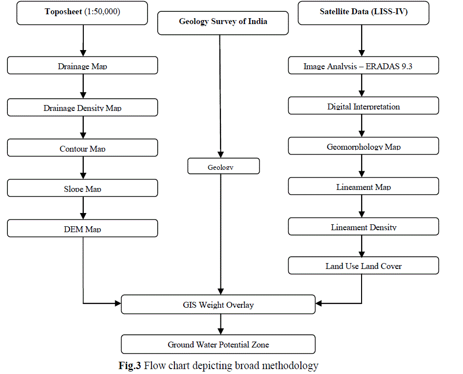
| In present study area lineaments are extracted from satellite image. All lineament are associated with geomorphic lineament i.e. drainage parallel. The study area is covered by major and minor lineament, magnitude varies from1.57 Km to 3.37 Km. The lineament map is then converted into zones of different lineament density. Lineament density map is a measure of quantitative length of linear feature expressed in (Km/Km2). Lineament density of an area has direct influence on groundwater prospectiveness of that area. In present study area with very high lineament density (2.11- 2.69) having good groundwater potential where as area with very low lineament density (0-0.34) having poor groundwater potential. The entire map classified in five categories as follow and depicted in Fig.8. |
 |
 |
4. Geomorphology |
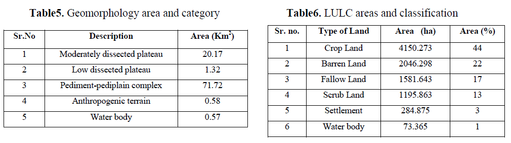
| Geomorphology is the study of the form of the earth (landform), its description and genesis (Gupta, 2003). It is a branch of earth science, which has grown after the advent of aerial photographs and satellite data. Geomorphology, along with information on soil, water and vegetation has become one of the essential inputs in planning for various developmental activities. Geomorphology of an area depends upon the structural evolution of geological formation. Geomorphology reflects various land form and structural features. Many of the features are favourable for the occurrence of groundwater and classified in terms of groundwater potentiality. The geomorphic units of the basin can be divided into moderately dissected lower plateau, low dissected lower plateau, pediment-pediplain complex, anthropogenic terrain, waterbodies. Among these pediplain are good in groundwater potential. The present study follows the classification of geomorphology by National Remote Sensing Centre (NRSC).based on ground truth verification, the geomorphology of the study area has been classified into five categories with their areal extend as depicted in Fig.9. |
A. Plateaus |
| Plateaus are flat topped residual mountains seen in plains. They are one of the four major landforms, along with mountains, plains and hills. They are divided into two categories as moderately dissected and low dissected plateau. Moderately dissected plateau occupies the eastern and a part of north region of basin with aerial extent of 20.17 Km2. It covered one fourth region of basin. Low dissected plateau is seen on northeast region of basin with an aerial extent of 1.32 Km2. Erosion can influence the shape of a plateau. Sometimes, plateau is so eroded that it is broken up into smaller raised sections. Nature of plateau is such that it accelerates more run off so it falls under the category of poor groundwater potential zone. |
B. Pediments- Pediplain complex |
| Pediment as the term suggests, feature usually formed at the foot of mountain. Pediments occur as gently undulating plains with moderate slope. The pediment is a terrestrial erosional foot slope surface inclined at a low angle and lacking significant relief in all direction. Presence of any lineaments or fractures can provide some scope for movement of groundwater potential. The pediplains are formed as result of weathering under arid and semi arid conditions, representing the end stage of cyclic erosion (king, 1950; Sparks, 1960). A pediment is developed by a combination of process including stream erosion, weathering, sheet wash and lateral plantation. When the sediment developed over a large area as result of continuous process of pedimentation, it is normally termed as a pediplain(Agarawal and garg, 2000). Pediplain is seen on large portion of basin with an aerial extent of 71.72 Km2. Most of the agriculture land in study area is constituted by pediplain and groundwater potential is good to moderate in this region. |
C. Anthropogenic terrain |
| Artificial lakes created by construction of dams across the river. They appears in light blue to dark blue and possess regular to irregular shapes. They are associated with crop lands, low land, and hills with or without vegetation. The terrain have an extent of 0.58 Km2. Water body category comprises area with surface water, in the form of ponds, lakes and reservoir or flowing as streams, rivers, canal etc. these appear as blue to dark blue in colour. In study area water body covers total area of 0.57 Km2. |
 |
5. Land use/ Land cover |
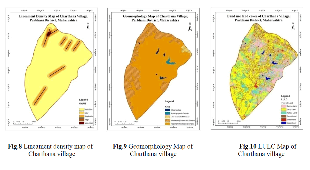
| Land use/land cover mapping is one of the important applications of remote sensing. Land use plays a significant role in the development of groundwater resources. It controls many hydrgeological processes in the water cycle viz., infiltration, evapotranspiration, surface runoff etc. surface cover provides roughness to the surface, reduce discharge thereby increases the infiltration. In the forest areas, infiltration will be more and runoff will be less whereas in urban areas rate of infiltration may decrease. Remote sensing provides excellent information with regard to spatial distribution of vegetation type and land use in less time and low cost in comparison to conventional data.LULC of study area has been analyzed for 2011 LISS IV image. Supervised classification of study area shows that major portion in land use is crop land covering area 4150.273 ha., barren land covering area 2046.298 ha., fallow land covering area 1581.643 ha., scrub land covering area 1195.863 ha., water body covering area 73.365 ha., and settlement covering area 284.875 ha. as depicted in Fig.10. |
ASSIGNING RANK AND WEIGHT |
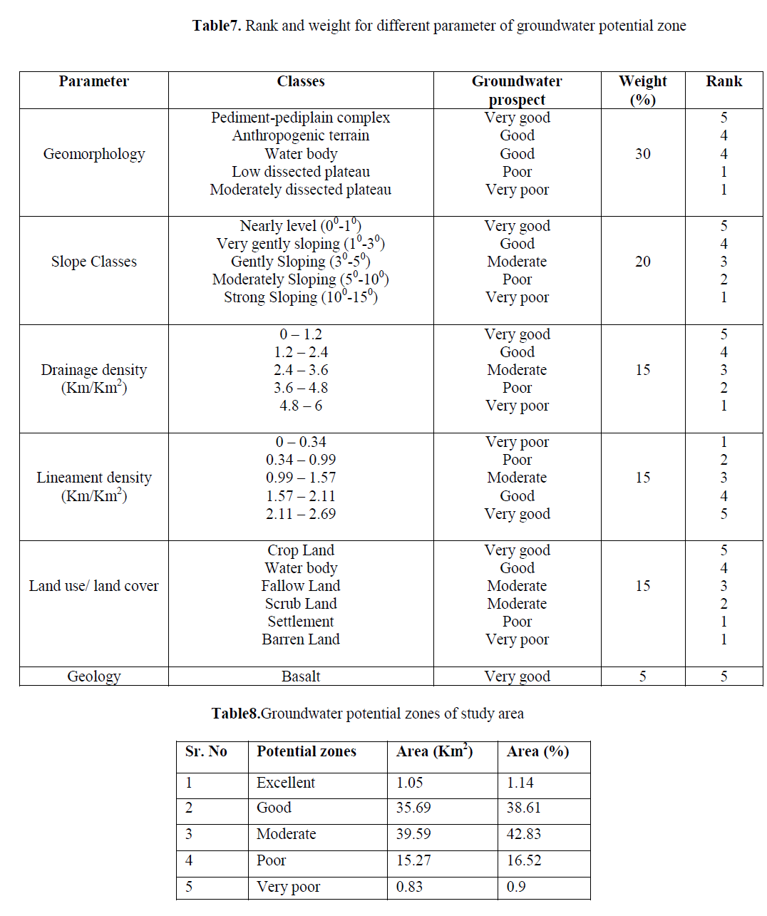
| The groundwater potential zones are obtained by overlaying all the thematic maps in terms of weighted overlay method using the spatial analysis tool in ArcGIS 10.1. During the weighted overlay analysis, the ranks have been given for each individual parameter of each thematic map and the weight is assigned according to the influence of the different parameters. The weights and rank have been taken considering the works carried out by researchers such as (Krishnamurthty et al 1996, Saraf & Chowdhary 1998). |
| All the thematic maps are converted into raster format and superimposed by weighted overlay method (rank and weight wise thematic maps and integrated with one another through GIS (Arc/Info grid environment).For assigning the weight, the slope and geomorphology were assigned higher weight, whereas the lineament density and drainage density were assigned lower weight. After assigning weights to different parameters, individual ranks are given for sub variable. In this process, the GIS layer on lineament density, geomorphology, and slope and drainage density were analyzed carefully and ranks are assigned to their sub variable (Butler et al., 2002, Asadi et al., 2007, Yammani, 2007). |
| The maximum value is given to the feature with highest groundwater potentiality and the minimum given to the lowest potential feature. The landforms such as moderately dissected plateau are given highest rank and lower value is assigned for pediplain. As far as slope is concerned, the highest rank value is assigned for gentle slope and low rank value is assigned to higher slope. The higher rank factors are assigned to low drainage density because the low drainage density factor favors more infiltration than surface runoff. Lower value followed by higher drainage density. Among the various lineament density classes the very high lineament density category is assigned higher rank value as this category has greater chance for groundwater infiltration. Lower value is assigned for very low lineament density. In LULC high rank is assigned to crop land and low value is assigned to barren land. The overall analysis is tabulated in Table7. |
 |
 |
 |
CONCLUSION |
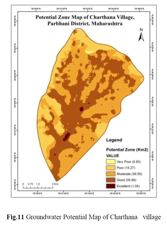
| Geographical information system and remote sensing has proved to be powerful and cost effective method for determining groundwater potential in parts of Parbhani district. The study reveals that integration of six thematic maps such as drainage density, slope, geology, geomorphology, lineament density and land use/land cover gives first hand information to local authorities and planners about the areas suitable for groundwater exploration. The given study area is classified in to excellent, good, moderate, poor and very poor groundwater potential zones and indicated in Fig.11. As per Table 7 and 8, it can be seen that the Area having slope 00 to 10, lineament density 2.11 to 2.69, drainage density 0 to 1.2 under Pediment-pediplain and cover with crop land is observed as excellent groundwater potential zone and covers area 1.05 Km2, the area having slope 10 to 30, lineament density 1.57to2.11, drainage density 1.2 to 2.4 under Pediment-pediplain, water body and cover with fallow land and crop land is observed as good groundwater potential zone and covers area 35.69 Km2, the area having slope 30 to 50, lineament density 0.99 to 1.57, drainage density 2.4 to 3.6 under Pediment-pediplain, and some lower part of Low dissected plateau and cover with scrub, crop and fallow is observed as moderate groundwater potential zone and covers area 39.59 Km2, the area having slope 50 to 100, lineament density 0.34 to 0.99, drainage density 3.6 to 4.8 under Low dissected plateau with crop , scrub, barren land is observed as poor groundwater potential zone and covers area15.27 Km2 and the area having slope 100 to 150, lineament density 0 to 0.34, drainage density 4.8 to 6 under Moderately dissected plateau and cover with crop , scrub, barren land is observed as very poor groundwater potential zone and covers area 0.83 Km2. This groundwater potential information will be useful for effective identification of suitable locations for extraction of water. Further, it is felt that the present methodology can be used as a guideline for further research. |
ACKNOWLEDGMENT |
| Authors are thankful to Dr. R R Hermon, Head C-GARD, National Institute of Rural Development, Hyderabad (Andhra Pradesh) and T. Phanindrakumar, Consultant, C-GARD, National Institute of Rural Development for providing workstation and valuable guidance for completing research work. Authors are also thankful to authorities of SGGS Institute of Engineering and Technology for their constant encouragement and support. |