International Journal of Innovative Research in Science, Engineering and Technology
ISSN ONLINE(2319-8753)PRINT(2347-6710)
ISSN ONLINE(2319-8753)PRINT(2347-6710)
Manikandan.J 1, Kiruthika.A.M 2, S.Sureshbabu 3
|
| Related article at Pubmed, Scholar Google |
Visit for more related articles at International Journal of Innovative Research in Science, Engineering and Technology
Increase in the demand of water for industrial and human purposes has brought an awareness to save ground water resources which is the primary source. Remote sensing data and the Geographical Information System (GIS) can be integrated for the exploration of groundwater resources and it becomes a breakthrough in the field of groundwater research, which assists in assessing, monitoring, and conserving groundwater resources. An attempt has been made in the present study to delineate groundwater potential zones of Krishnagiri district, Tamil Nadu using remote sensing and GIS techniques. Survey of India toposheets and LISS-IV satellite imageries are used to prepare various thematic layers viz. slope, land-use/land-cover, drainage, soil, geology, geomorphology and rainfall. The thematic layers that are in vector are converted to raster using feature to raster converter tool in ArcGIS10. The raster maps of these factors are allocated a fixed score and weight computed from Multi Influencing Factor (MIF) technique. Moreover, each weighted thematic layer is statistically computed to yield a groundwater potential zone map of the study area. The groundwater potential zones thus obtained were divided into four categories, viz., very poor, poor, good, and very good zones. The result depicts the groundwater potential zones in the study area and creates awareness in better planning and management of groundwater resources.
Keywords |
| Remote Sensing, Geographic Information System, ARCGIS10,MIF Technique. |
INTRODUCTION |
| Groundwater is a vital natural resource for both agricultural and industrial use, the need to develop groundwater resources to the maximum possible extent has gained importance. Therefore, to delineate the parameters governing groundwater resources and assessment so as to predict groundwater potential is essential for planning and developing this resource. Although it is more dynamic renewable natural resource yet availability with good quality and quantity in appropriate time and space is more important [1]. To investigate the ground water directly from the field is very costly, time-consuming and requires skilled manpower [7]. In contrast, space technology-with its advantages of spatial, spectral & temporal availability of data covering large and inaccessible areas within a short time, has appeared as a very valuable tool for the assessment, monitoring and management of groundwater resources [4]. Delineating the potential groundwater zones using remote sensing and GIS is an effective tool. Extensive use of satellite data along with conventional maps and rectified ground truth data, has made it easier to establish the base line information for groundwater potential zones [10, 1, 2, 3, 5]. In the past, several research are carried out by a number of researchers around the world, and it was found that the involved factors in determining the groundwater potential zones were different, and hence the results vary accordingly. Then the researchers merged different factors apart from lineaments like drainage density, geomorphology, geology, slope, land-use, rainfall intensity and soil texture [7, 8]. The derived results are found to be satisfactory based on field survey and it varies from one region to another because of varied geoenvironmental conditions. Integration of remote sensing with GIS for preparing various thematic layers that have direct or indirect control over groundwater occurrence with assigned weightage in a spatial domain will support the identification of potential groundwater zones. Therefore, the present study focuses on the identification of groundwater potential zones in Krishnagiri district, Tamil Nadu using the advanced technology of remote sensing [6], MIF and GIS for the planning, administration, and management of groundwater resources. |
OBJECTIVES |
| The objectives of this study are |
| To prepare thematic maps on surface and sub-surface features viz: Geology, Geomorphology, Soil, Slope, Drainage & its density, Landuse/landcover. Rainfall. |
| To Assign weightage for each theme based on MIF technique. |
| To integrate all thematic maps using GIS and demarcating groundwater prospective zones of the study area. |
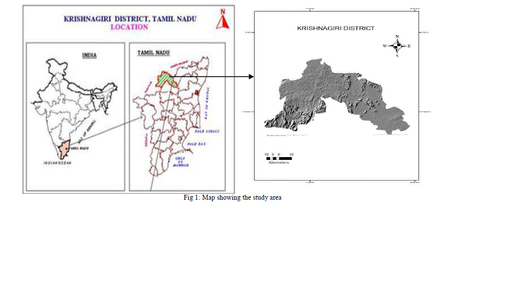
STUDY AREA |
| The study area falls under Krishnagiri district, Tamil Nadu between North latitudes 11°12' and 12°49' & East longitudes 77°27' and 78°38'. Krishnagiri is one of the largest districts in Tamil Nadu and its area is 5143 Sq. Kms. The average rainfall is 830 mm per annum. It has an average elevation of 631metres(2070 ft). The main rivers that flow across the district are Kaveri and South Pennar Kaveri enters the district from South West in Denkanikottai taluk and exists in South West direction. |
 |
METHODOLOGY |
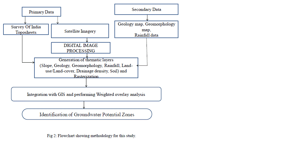
| The methodology adopted for the present study is shown in Fig.2. Survey of India (SOI) topographic sheets are used for generation of base map. The topographical maps no. 57L/2,3,6,7,8, 11,12, 57H/10,11,13,12, 14,15. The secondary data used are geology and Mineral map (1:2,50,000), geomorphology map (1:10,00,000) from Geological Survey Of India which are needed for generation of Lithological features. The slope map was prepared from SRTM DEM data in ArcGIS Spatial Analyst module. The rainfall map was prepared using data obtained from Central Ground Water Board. These data were then spatially interpolated using KRIGING method to obtain rainfall distribution map. The drainage density map was prepared using the line density analysis tool in ArcGIS. Satellite images from IRS-p6, LlSS-IV sensor with the spatial resolution of 5.3m have been used for delineation of thematic layer such as land-use/ land-cover. The thematic layers that are in vector format are converted in to raster format and loaded in to GIS environment. Ground water potential zones were identified by overlaying all the thematic maps in terms of weighted overlay methods using the spatial analysis tool in ArcGIS 10. During weighted overlay analysis, the ranking was given for each individual parameter of each thematic map, and weights were assigned according to the multi influencing factor (MIF) of that particular feature on the hydro-geological environment of the study area (Shaban et al., 2006). |
 |
| A. Multi influencing factors of groundwater potential zones |
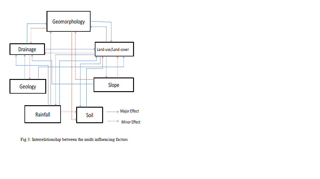
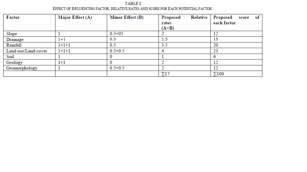
| Seven influencing factors, such as geology, slope, land-use/land-cover, geomorphology, drainage, soil, and rainfall have been identified to delineate the groundwater potential zones. Interrelationship between these factors and their effect is shown in Fig. 3. Each relationship is weighted according to its strength. The representative weight of a factor of the potential zone is the sum of all weights from each factor. A factor with a higher weight value shows a larger impact and a factor with a lower weight value shows a smaller impact on groundwater potential zones. Integration of these factors with their potential weights is computed through weighted overlay analysis in ArcGIS. |
 |
| B. Weightage calculation |
| The multi influencing factors for groundwater potential zones namely geology, slope, land-use/land-cover, geomorphology, drainage, soil, and rainfall were examined and assigned an appropriate weight and are shown in Table 1. The effect of each influencing factor may contribute to delineate the groundwater potential zones. Moreover, these factors are interdependent. The effect of each major and minor factor is assigned a weightage of 1.0 and 0.5 respectively (Fig. 3). The cumulative weightage of both major and minor effects are considered for calculating the relative rates (Table 1). This rate is further used to calculate the score of each influencing factor. The proposed score for each influencing factor is calculated by using the formula. |
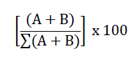 |
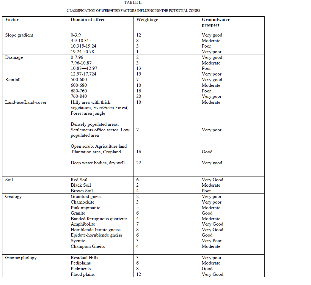
| where, A is major interrelationship between two factors and B is minor interrelationship between two factors. The concerned score for each influencing factor was divided equally and assigned to each reclassified factor (Table 2). |
 |
 |
RESULTS AND DISCUSSION3` |
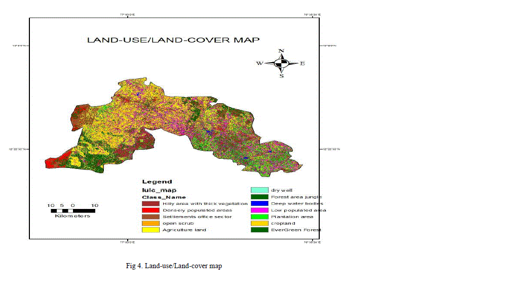
A. LAND-USE/LAND-COVER |
| Land use/land cover is one of the important parameter for the geo-hydrological study because the land use pattern of any terrain is a reflection of the complex physical processes acting upon the surface of the earth. The major land-use/land-cover type in the study area are crop land, hilly area, reserved forest, barren land, agriculture and settlements(Fig.4). These classes are identified from IRS-P6 LISS-IV satellite data and field verification. Forest area covers 202409 Ha which covers major portion of the study area, around 4991 Ha are under cultivation. |
 |
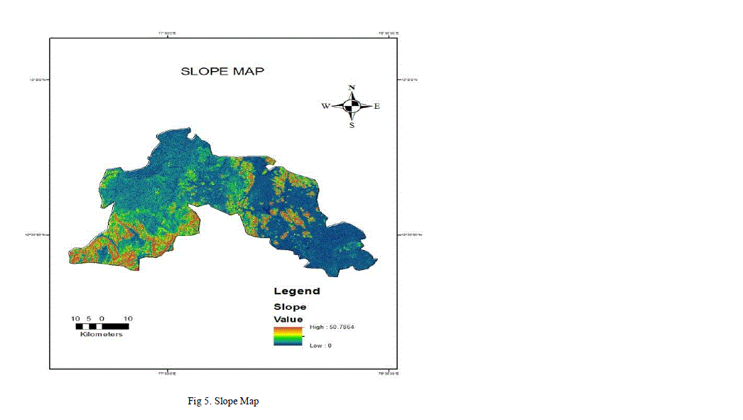
B. SLOPE |
| Slope is an important factor for the identification of groundwater potential zones and it is also one of a factor controlling infiltration of groundwater into subsurface; hence an indicator for the suitability for groundwater prospect. The slope map of the study area was prepared based on SRTM data using the spatial analysis tool in ArcInfo 10. A high sloping region causes more runoff and less infiltration and thus has poor groundwater prospects compared to the low slope region. The study area can be divided in to four classes based on slope. The areas having 0-3.9 slope fall into ‗very good‘ category because of nearly flat terrain and has high infiltration rate. The areas having 3.9-10.315 slope fall into ‗good‘ category. The areas having 10.315-19.24 slope fall into ‗poor‘ category. The areas having 19.24-50.78 slope fall into ‗very poor‘ category due to higher slope and run-off.(Fig.5). |
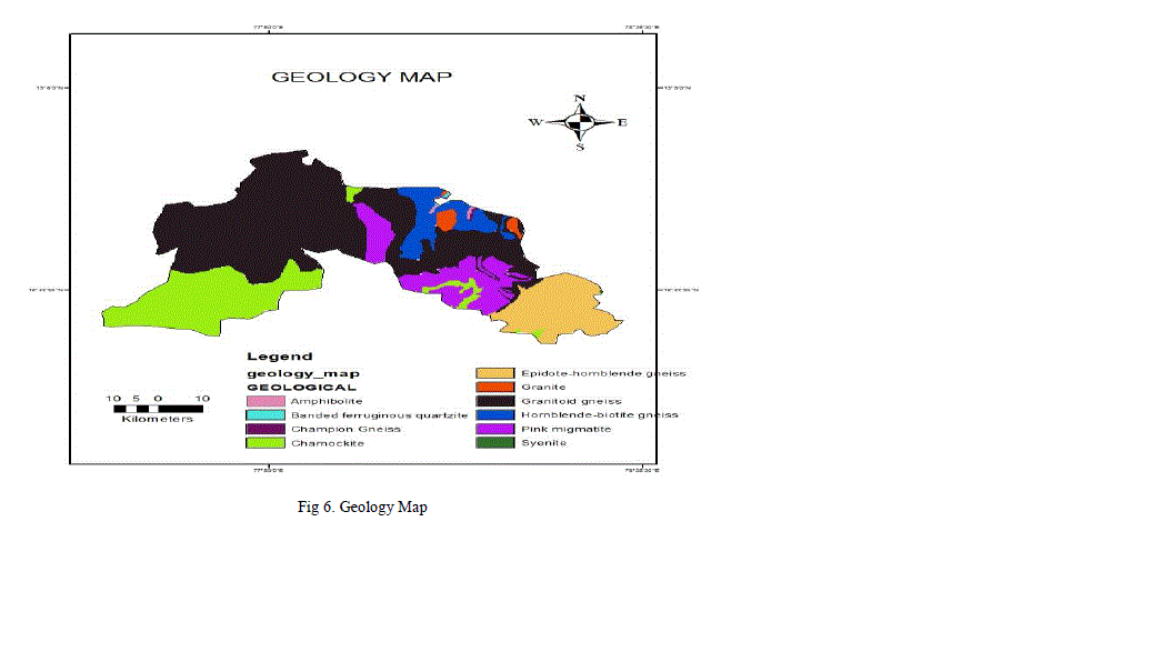
C. GEOLOGY |
| The storage capacity of the rock formations depends on the porosity of the rock. In the rock formation the water moves from areas of recharge to areas of discharge under the influence of hydraulic gradients depending on the hydraulic conductivity or permeability. The study area contains Gneisses, Granites , Charnockite, Granitoid gneiss as major geological structure (Fig.6). |
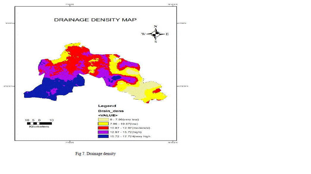
D. DRAINAGE DENSITY |
| Drainage pattern reflects the major characteristic of surface as well as subsurface formation. More the drainage density, higher would be runoff. Drainage density of the study area is calculated using line density analysis tool in ArcGIS software. The suitability of groundwater potential zones is indirectly related to drainage density because of its relation with surface runoff and permeability. The study area is grouped in to 4 classes and assigned to ‗very good‘(12.97-17.724 km/km2), good(10.87-12.97km/km2), poor(7.96-10.87 km/km2), very poor(0-7.096km/km2). The drainage density map is shown in Fig.7. |
E. SOIL |
| Soil characteristics invariably control penetration of surface water into an aquifer system and they are directly related to rates of infiltration, percolation and permeability. The study area is predominantly controlled by red soil and alluvial soil. It plays an important for delineating the ground water potential zones. Study area also has contains brown and black soil. |
F. RAINFALL |
| The annual average rainfall of the study area is around 850 mm. Rainfall distribution along with the slope gradient directly affects the infiltration rate of runoff water hence increases the possibility of groundwater potential zones. The geomorphological map is shown in Fig.8 |
G. GEOMORPHOLOGY |
| Climate and geomorphological characteristics of an area affect its response to a considerable extent. There are four different types of landforms present in the study area. It involves the identification and characterization of various landforms and structural features. Many of these features are favourable for the occurrence of groundwater and are classified in terms of groundwater potentiality. The study area has various landforms such as flood plains, pediments, pediplains and residual hills. The geomorphological map is shown in Fig.9 |
H. DELINEATING GROUND WATER POTENTIAL ZONE: |
| The groundwater potential zones for the study area were generated through the integration of various thematic maps viz., drainage, slope, lithology, soil, lineament, rainfall and land-use using remote sensing and GIS techniques. The identification of groundwater potential zones for the study area was made by grouping of the interpreted layers through weighted multi influencing factor and finally assigned different potential zones. The groundwater potential zone of this study area can be divided into five grades, namely very good, good, moderate, poor, and very poor. The groundwater potential map demonstrates that the excellent groundwater potential zone is concentrated in the south-east parts of the study area due to the presence of agriculture land and scrub land which holds high infiltration capability. Most of the region in study area concerns good level of ground water potential zone and hill side areas has very poor ground water potential zones. The ground water potential zones for the study area is shown in fig.10. |
 |
 |
 |
CONCLUSIONS |
| Identifying the ground water potential zones in Krishnagiri district of Tamill Nadu using geo spatial techniques which includes remote sensing, GIS and MIF techniques is found efficient to minimize time and money. Satellite imageries, topographic maps and conventional data were used to prepare the thematic layers of lithology, lineament density, drainage density, slope, soil, land-use and rainfall. The various thematic layers are assigned proper weightage through MIF technique and then integrated in the GIS environment to prepare the groundwater potential zone map of the study area. According to the groundwater potential zone map, Krishnagiri district is categorized in to five different zones namely ‗very good‘, ‗good‘, ‗moderate‘, ‗poor‘, ‗very poor‘. The result of the present study can be used to maintain water resources management and planning future artificial recharge projects in the study area. |
ACKNOWLEDGMENT |
| I would like to thank Mr. N.S. Magesh, Centre for Geotechnology, Manonmaniam Sundaranar University, Tirunelveli, Tamil Nadu 627012, India for supporting this project and Mrs. Kiruthika.A.M, Assistant Professor, College Of Engineering Hosur-635109, Tamil Nadu, India, Mr. S.Sureshbabu, professor & Head of Department for guidance. |
References |
|