International Journal of Innovative Research in Science, Engineering and Technology
ISSN ONLINE(2319-8753)PRINT(2347-6710)
ISSN ONLINE(2319-8753)PRINT(2347-6710)
G.D. Bhatt1 , Komal Sinha1, P.K. Deka2, Ajay Kumar3
|
| Related article at Pubmed, Scholar Google |
Visit for more related articles at International Journal of Innovative Research in Science, Engineering and Technology
Flood is a major environmental problem in India as it has devastating effects on life and property. The objective of present study is to delineate and identify flood hazard and risk assessment at landscape level using Landsat satellite data from 1974-2013 in Chamoli District, Uttarakhand, India covering total geographical area of 8030 km2. The study area lies between 30-31° N latitude and 79-80° E longitude. The satellite data was ortho-rectified and the study area was extracted using district boundary. The vegetation type/land use map was prepared using on-screen visual interpretation technique. The multi-flood time series dataset was used for preparation of Digital Elevation Model. Geographical Information System was used for identification of flood prone areas which were classified with zone-wise. A flood frequency map was developed using the multi-date Landsat satellite imagery. The classified vegetation type/land use map from 1974-2013 was overlaid to find out the frequency of the flood. Flood affected areas were classified into very low, low, medium, high, very high and extremely high based on vulnerability to the potential of flood hazard. The areas were further categorized, based on the vulnerability of flood viz; extremely high (6) very high (5), high (4), medium (3), low (2) and very low (1) respectively. The study assigned the scores to each class for further determination of risk zone in various thematic layers such as slope, aspect and elevation. The incorporation of all thematic layers and flood frequency map was generated to prepare flood hazard and risk map using GIS platform. Flood frequency and flood prone areas were calculated using DEM. The vegetation type/land use map was integrated for creation of flood hazard and risk assessment. Based on this analysis the flood risk zones at different levels and intensity in the Chamoli district were prepared. This flood hazard and risk assessment maps will be useful to management and mitigate losses of lives and property from recurrent flood disasters in Chamoli District. This model can also be applied to comparable areas in Himalayas.
KEYWORDS |
| Flood hazard and risk assessment, Landsat satellite imagery, On-screen visual interpretation technique, Remote sensing and GIS, Vegetation type/land use |
I. INTRODUCTION |
| Generally flood is the most devastating, widespread and frequent natural hazard of the world [1]. Apparently, this is, for the large part, due to the heavy rainfall for long days on the upstream highlands [2]. The rain has caused most rivers to swell and overflow of their courses, submerging the surrounding, flat fields or floodplains, which are mostly located in the outlying pastoralist regions of the country [3]. In the period 1994-2004, Asia accounted for one third of 1,562 flood disaster worldwide and nearly 60,000 people were killed due to the flood [4]. Every year, flood disaster results in tremendous losses and social disruption across the world [5]. In the last 30 years, flood has been the most catastrophic natural disaster affecting, on an average, about 80 million people per year of the total population affected by any natural disaster, causing economic damage worth over US$11 million annually around the world [5]. As increasing human population and its interaction with downstream of river is greater reason for flood damages to the natural resources. |
| Flood itself is also increasing in size and frequency due to human activities in the upstream section of the river system [6]. Geographic Information System (GIS) is a computer based system that provides the capabilities for input, data management, data storage and retrieval, manipulation, analysis and output to handle spatial data [7] [8]. GIS provides a broad range of tools for determining areas affected by flood and for forecasting areas that are likely to be flooded due to rise in water level in a river [9]. The main benefit of GIS for flood management and planning is that, it generates visualization of flood prone areas that creates potential to further analysis the product to estimate probable damage due to flood [10] [11]. GIS has been extensively used to assemble information from different spatial data, aerial photographs, satellite images and Digital Elevation Model (DEM) [12] [13] [14]. The main focus in this field revolves around delineation of flood zones and preparation of flood hazard and risk maps for the vulnerable areas [15]. River flooding in the developing countries of Asia is very acute because of their heavy dependence on agriculture but any flood estimation and hazard mapping attempt in this region is handicapped by poor availability of high resolution DEMs [16]. Flood hazard mapping is a vital component for appropriate land use planning in flood prone areas. It creates rapidly accessible charts and maps, which facilitate the administrators and policy makers to identify areas of risk and prioritize their mitigation and response efforts [17]. The regulation of flood hazard areas coupled with enactment and enforcement of flood hazard zone could prevent damage of life and property from flood in short term as well as in long term [18]. Flood management is necessary not only because flood imposes a curse on the society, but the optimal exploitation of the land, proper management and control of water resources are of vital importance for bringing prosperity in the predominantly agriculture based economy of highly populated area [19]. This cannot become technically feasible without effective flood hazard and risk maps. Flood risk mapping is the vital component in flood mitigation measures and land use planning [20]. Satellite-based remote sensing images have been used to map the extent of flood inundation since the early 1970 [21] [22]. Most of the early studies used optical remote sensors, such as Landsat MSS and TM [23] [24]. But optical sensors cannot penetrate clouds, which nearly always accompany flood events; so they have been mainly used to observe post flood inundation extent [25]. The present research has the two objectives 1) prepare vegetation type/ land use map on 1:50, 000 scale using Landsat satellite data on wet and dry season with spatial resolution of 30 m 2) The flood hazard and risk assessment was developed for conservation planning and management in the Himalayan regions. |
II.MATERIAL AND METHODS |
STUDY AREA |
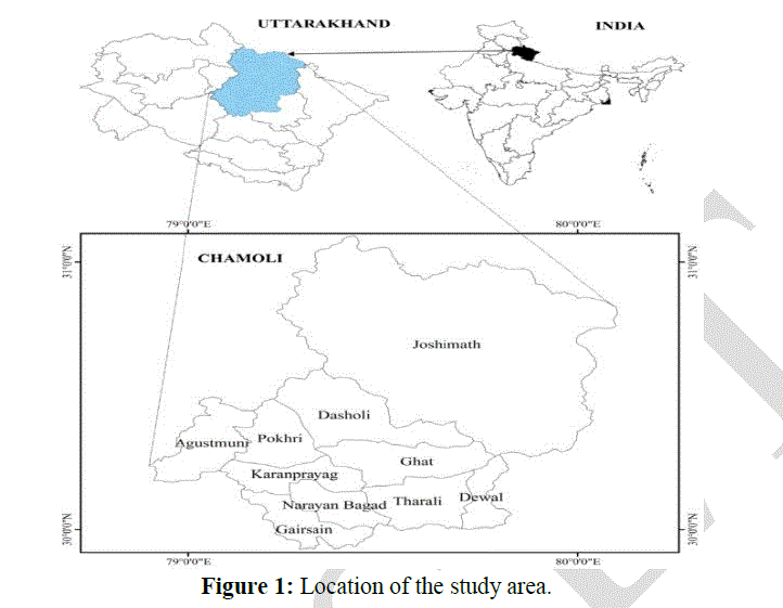
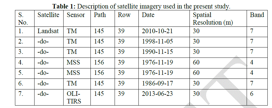
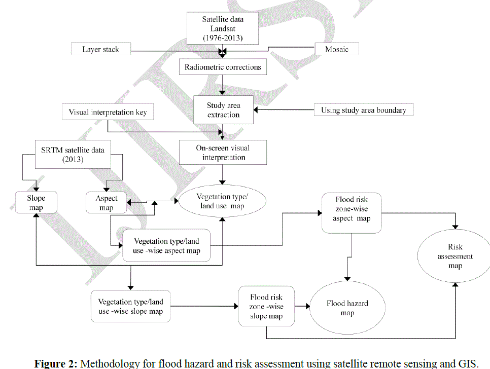
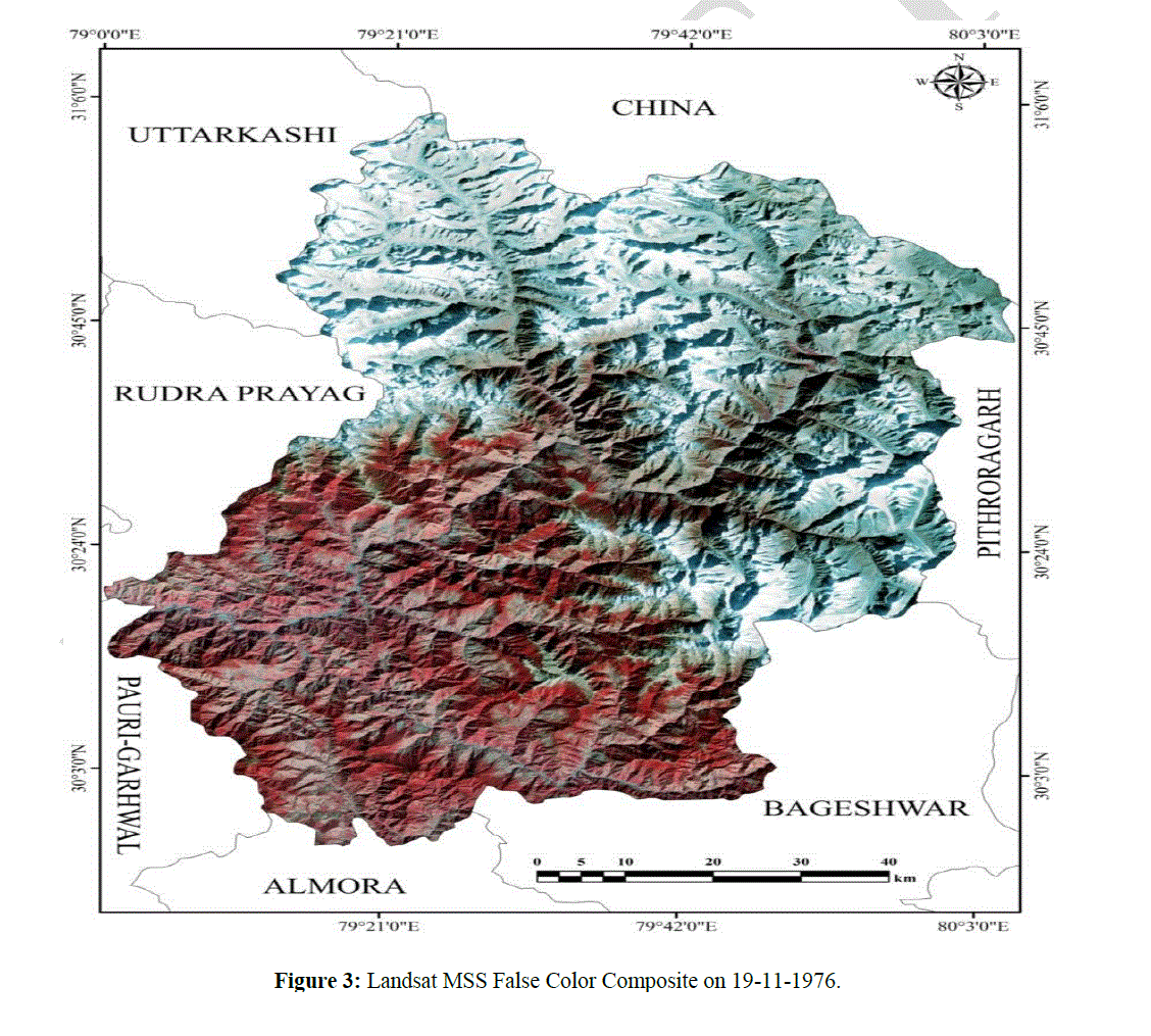
| Chamoli district is the second largest district of Uttarakhand state of India (Figure 1). The administrative headquarters of the district is Gopeshwar. The study area lies between 79ï° to 80ï° E and 30ï° to 31ï° N. It is bounded by the Tibet region to the north and by the Uttarakhand districts of Pithoragarh and Bageshwar to the east, Almora to the south, Garhwal to the southwest, Rudraprayag to the west, and Uttarkashi to the northwest. Administratively the district is divided into six tehsils namely viz; Joshimath, Chamoli, Karnaprayag, Pokhari, Gairsain and Tharali. Further it is divided into nine development blocks viz; Joshimath, Dasoli, Pokhari, Ghat, Karnaprayag, Tharali, Narayanbagar, Dewal and Gairsain. The elevation of the district ranges from 800-8000 m. The climate of the district is depends on the altitude. The winter season is from November to March. As most of the region is situated on the southern slopes of the outer Himalaya, monsoon currents can enter through the valley, the rainfall being heaviest in the monsoon from June to September. The rainfall occurs during June to September when 70 to 80 percent of the annual precipitation is accounted for in the southern half of the district and 55 to 65 percent in the northern half [26]. The major river in the study area is Alaknanda and Ramganga. The tributaries in the study area are: Dhauli Ganga, Birhi Ganga, Nandakini and Pindar etc. The major crops are: rice, wheat, potato, pulses, millets, seasonal vegetables and fruits respectively. The Landsat satellite data was procured from United States Geological Survey (USGS) website (http://glovis.usgs.gov). The satellite data was radiometrically or environmentally corrected using histogram equalization, dark pixel subtraction, line striping, noise correction, haze correction and image contrast [27]. A total of six scenes covered whole of the study area (Table 1). The UTM projection and WGS 84 datum was used for the study area. For satellite image processing the nearest neighbour resampling method was used. The images were mosaiced using feather overlap function of ERDAS Imagine ver. 9.2 and the study area (8030 km2) was extracted using study area boundary. The complete methodology is shown in Figure 2. The satellite imagery was converted into False Color Composite (FCC) (Figure 3). Based on the FCC a visual interpretation key (tone, texture, shape, size, color, association and pattern) was generated and prepared a vegetation type/land use map using on-screen visual interpretation techniques (Figure 4). |
 |
 |
 |
 |
 |
 |
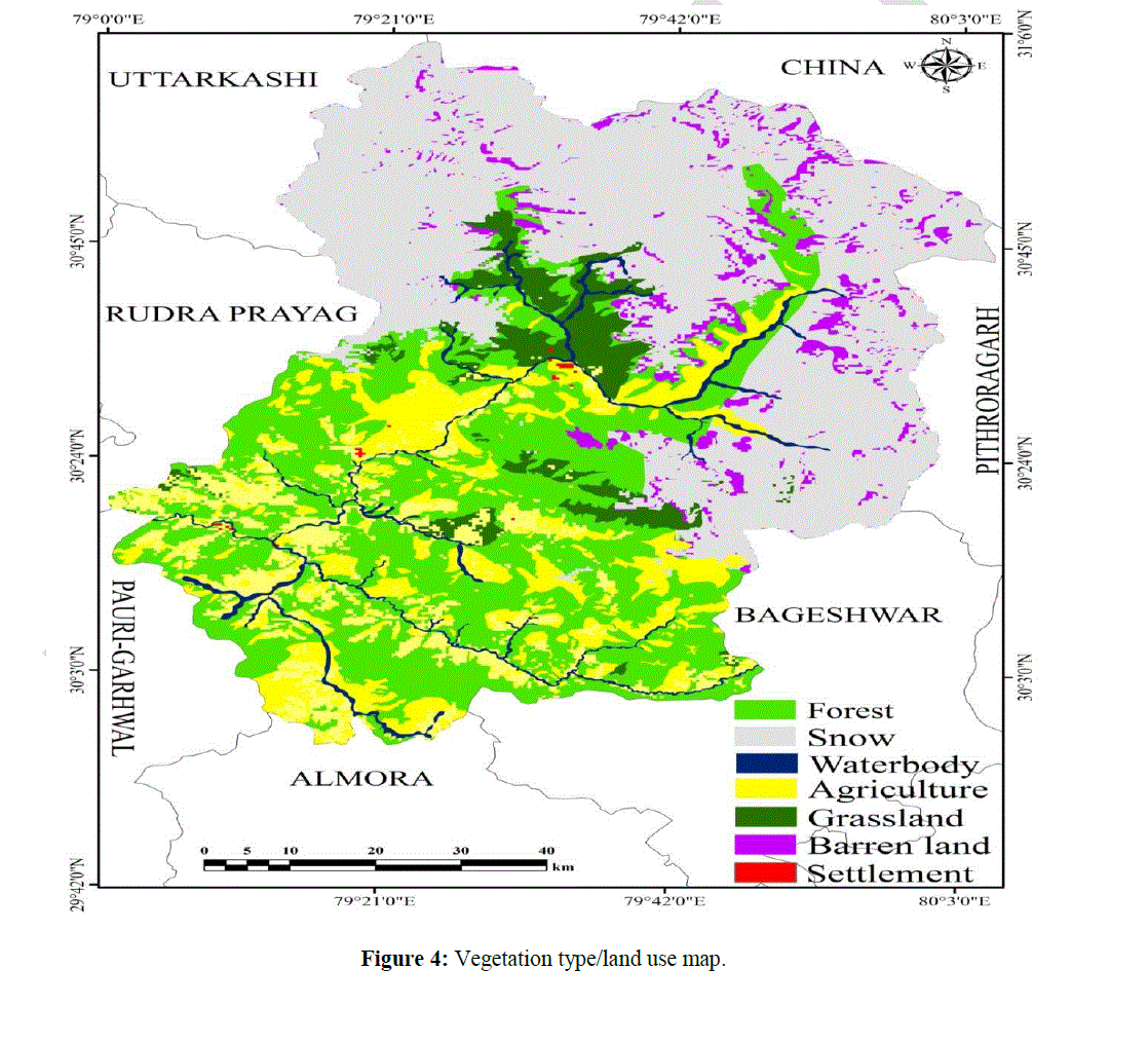 |
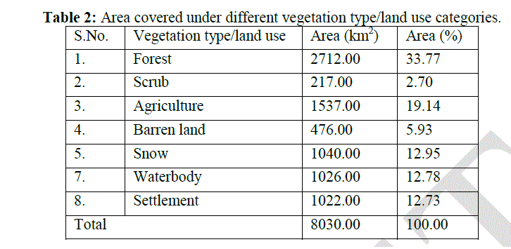
| The maximum area is covered by forest in land cover and in land use maximum area was covered by agriculture (Table 2). The digital elevation model was developed using Surface Reflectance Terrain Model (SRTM) for evaluation of the different elevation in the study area. Based on the DEM, the slope and aspect was generated to find out the vulnerability of flood hazard and risk assessment. The slope and aspect map was intersected with vegetation type/land use map. The intersect vegetation type/land use-wise slope and aspect map was generated to find out the vulnerability and risk of flood hazard in the study area. These input maps were used for preparation of flood hazard and risk assessment at landscape level in Chamoli district of Uttarakhand. When the flooded areas were identified, this information was combined with the frequency of flood and land use data in order to assess and to estimate the number of people is affected in settlement areas and land use types of the damaged areas. Settlement areas are not only centers of human activities but also includes the main portion of human properties for a vital role in the flood hazard and risk assessment (Figure 5). |
III.RESULTS AND DISCUSSION |
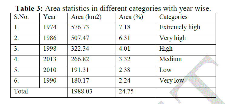
| The vegetation type/land use map is prime input for flood hazard and risk assessment at landscape level [28] [29] [30]. The vegetation type/land use map was prepared using Landsat satellite data using on-screen visual interpretation techniques. The vegetation type/land use map was categorized in eight classes viz; forest, scrub, agriculture, barren land, snow, waterbody and settlement respectively. The maximum area is covered by forest 2712.00 km2 (33.77 %) followed by agriculture 1537.00 km2 (19.14 %), snow 1040.00 km2 (12.95 %) and waterbody 1026.00 km2 (12.78 %) respectively (Figure 4). The flood frequency map was generated from 1974 to 2013 using Landsat series data set was used. Based on these dataset a flood hazard and risk assessment map was developed. The extremely high flood was found in 1974 and very low was observed in 1990. Very high flood was observed in 1986 followed by 1998, 2013 and 2010 respectively. In 1974 flood was high in rainy season so, loss was observed in natural vegetations. But in 2013 the rainfall was occurs in June due to early rainfall in the study area and snow fall in high altitude caused the flood. The high soil erosion was found in the upstream sediments and dissolved substances cumulatively in river load deposited in the river channels and on adjacent flood plains in downstream of the major rivers. As per field observation, sediments deposited in Alaknanda, Bhagirathi river and its tributaries have changed the rivers gradient, cross sectional area, velocity and intensity of water flow and discharge of rivers. Therefore, overflow of rivers occurred and flooded the nearby areas. The cross sectional area of these rivers is decreasing from time to time as a result of sediment deposition. In some areas the depth of Alaknanda river decreased to 35-11 m. Some agricultural land crops and settlement have been buried by the deposited sediments. Over all, the river channels depth and width increased and the water discharging capacity of the major rivers and their tributaries gets minimized which leads to overflow of water and flood consecutively. Above findings indicates that the rate of erosion and soil loss in the upstream is high due to lack of abstraction flood water. Flood hazard and risk based approaches have received increasing attention as a viable means to manage flood hazard assessment [31] [32]. Flood hazard, risk and vulnerability assessment examines the hazards that may affect a community in order to determine the risk that each hazard event poses to both the community as a vulnerable element in the community [33] [34] [35]. Flood risk mapping is often the first step for flood risk management [36], and it provides data required for urban planning, wildlife habitat modelling and management, design for infrastructure, flood mitigation and response. Flood hazard and risk assessment yields risk maps, which can be created using GIS based hydrological observations of the frequency, magnitude and duration of flood events, as well as DEMs that characterize the topographic basin within which flood events occur [37] [38]. Flood risk maps can be used to identify the weaknesses in a flood defense system and the patterns of vulnerability of human infrastructure and wildlife habitat. Because of increasing human population density in flood prone areas throughout the world, as well as land use and climate changes that affect flood dynamics, and the combination of these in historically less information rich developing countries, efficient food risk mapping is an increasingly critical task [16]. DEM have been used in various ways to aid flood mapping and modeling [25]. They have been used as integral part of GIS database for hydrological flood modeling for spatial extent of inundation [39]. As natural disaster increase in both intensity and severity around the world, the Asian countries continue to suffer a disproportionate number of hazard events and related losses in lives, infrastructure, stability and economic progress [40] [41] [42]. More than half the world population lives in Asia, which is approximately one-fifth of the earth land area [43]. Based on the results of this study for Chamoli district, it can be concluded that remote sensing and GIS technology provides the potential tool for prompt effective decision-making and management on flood. The comprehensive flood hazard and risk assessment model developed in ArcGIS ver 10.1 can be easily operated by GIS users. The remote sensing and GIS techniques were used to classify the extent of floods. On-screen visual interpretation techniques for classification systems allowed different tonal variation for different classes that can be used further for similar types of flood mapping. This study demonstrates that information derived from different imagery can be valuable to operational users for flood related planning and emergency response. Natural flood disaster is common and cannot be stop, but we can reduce its impact can be minimized. Remote sensing and GIS is an effective tool for flood hazard, risk mapping, suitability analysis and disaster management. Watershed management practices in the uplands of the catchment are crucial in alleviating future flood disasters in the study area. Land use planning can play a very important role to minimize the adverse effects of flood. It is recommended to adopt an appropriate land use planning in flood prone areas. The ideal form of planning would be to evacuate the flood prone areas but practically it is not possible due to involvement of high costs and social problems. However, it is possible to change the functional characteristics of the flood plain areas. |
IV.ACKNOWLEDGMENT |
| Authors gratefully acknowledge the support and encouragement received from Head, Department of Petroleum Engineering and Earth Sciences, UPES Dehradun and Professor Dr. K.S. Misra for valuable suggestions. |
References |
|