International Journal of Innovative Research in Science, Engineering and Technology
ISSN ONLINE(2319-8753)PRINT(2347-6710)
ISSN ONLINE(2319-8753)PRINT(2347-6710)
G. Sujith1, P.V. Vinod2, M.S. Vinaya3, S. Suresh Babu4
|
| Related article at Pubmed, Scholar Google |
Visit for more related articles at International Journal of Innovative Research in Science, Engineering and Technology
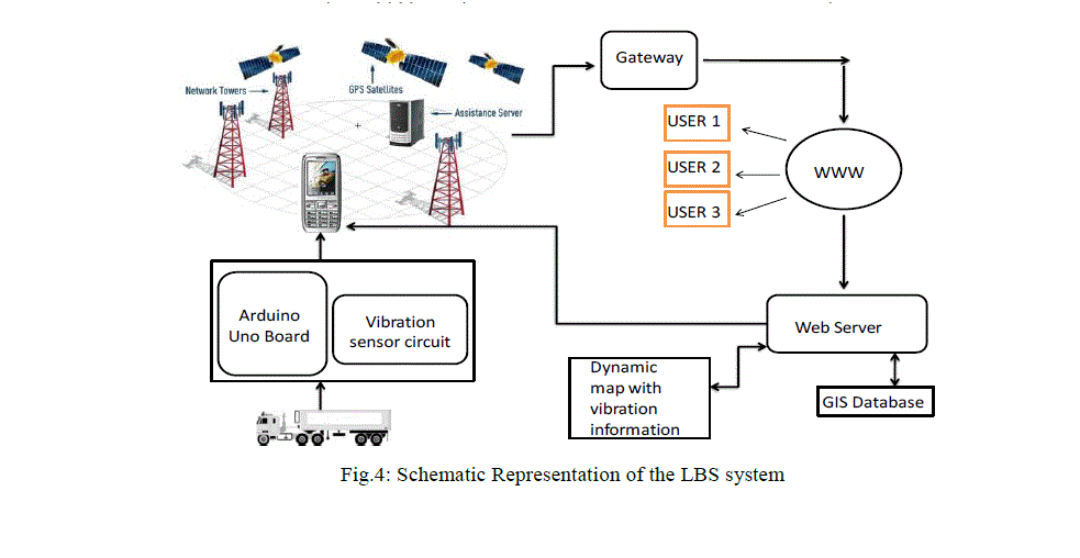
In the present study we propose the implementation of Location Based Service for real-time vibration monitoring of a moving vehicle. The purpose of this study is to prevent damage to delicate payload being carried by trucks or trailers which occurs due to vibrations during transportation. We have first designed a vibration detector circuit by connecting a vibration detector to an Arduino-Uno printed circuit board. This board was then interfaced to an Android smart phone with the help of a Bluetooth module. The sensor reading displayed on the Android smart-phone was sent over mobile GPRS to a web-GIS server. The data stored in the GIS database was then dynamically plotted as a line-graph on a web page and also overlaid on Google Earth’s satellite image in the form of a KML (Keyhole Markup Language) file
Keywords |
| Android Mobile Operating System, Arduino board, A-GPS, GIS, GPRS, KML, Location Based Services, Web Services. |
INTRODUCTION |
| Location-based services or LBS refer to a set of applications that exploit the knowledge of the geographical position of a mobile device in order to provide services based on that information. The basic components of LBS are service provider's software application, a mobile network to transmit data and requests for service, a content provider to supply the end user with geo-specific information, a positioning component (GPS), and the end user's mobile device. Location Based Service provides the users information services which originate from the geographic location of the end user mobile device. Using these services it is possible for the users to find current location and locate other persons, vehicle, resources etc. It is also used to provide location-sensitive services, in addition to tracking their own location. The request for location can originate in the mobile device or network operator. There are two methodologies to implement LBS - ïÃâ÷ To process location data in a server and to forward the generated response to the clients. ïÃâ÷ To find location data for a mobile device-based application that can use it directly. Android platform is a new generation of smart mobile phone platform launched by Google. Android provides the support of mobile map and Location Based Service. The most fascinating feature of Android smart phone is that, the phone’s hardware functionality is not only limited to the manufacturer’s interest, but also can be extended by the user. Hence external components such as sensors, robots and other remotely sensed objects may be connected to the Android smart phone which exploits the phone’s hardware and value-added services. The conception of the Android platform is attracting more and more programmers in mobile computing fields. Android is a package of software for mobile devices, including an operating system, middleware and core applications. The Android SDK provides powerful tools and APIs necessary to develop applications on the Android platform using the Java programming language. Android platform is of open system architecture, with versatile development and debugging environment, but also supports a variety of scalable user experience, which has optimized graphics systems, rich media support and a very powerful browser. It enables reuse and replacement of components and an efficient database support and support various wireless communication means. It uses a Dalvik virtual machine heavily optimized for mobile devices. Android also supports GPS, Video Camera, compass, and 3d-accelerometer and provides rich APIs for map and location functions. Users can flexibly access, control and process the free Google map and implement location based mobile service in his mobile systems at low cost. Android platform will not only promote the technology (including the platform itself) of innovation, but also help to reduce development costs, and enable developers to form their mobile systems with unique characteristics. A LBS application was developed by Manav et al. [1] to track vehicle location using A-GPS, Google web services, GPRS and walk-score transit APIs on Android phones to provide multiple services to user based on location. A similar application was developed by Radhika et al. [2] to provide location based services to find the route between two locations. Map overlays were created with annotations which responded to user clicks. The authors obtained a KML route file from Google and then created a document builder to pass the KML file. Muthumurugesan et al. [3] have used query processing and distance calculator to determine the distance between two locations, so as to select the shortest path to reach the destination. The authors in [4] have presented a new protocol that is focused on using cryptographic techniques to provide anonymity for LBSs users in the smart phone environment. The design of Spring-damper mechanical models based on different subjects for vibration data analysis and its effect on health proposed by the authors in [5] was a promising approach to obtain real-time vibrations with the help of sensors and data logger which were interfaced to the Arduino mega board. The work in this paper is divided into the following stages. 1) Develop a Location Based Service application on Android Operating System. 2) Design and interface of a vibration sensor circuit to the Android smart phone.3) Develop a server side application to receive the vibration information and store in it a Web GIS database.4) Display and serve the information using dynamic mapping technique. |
II.MATERIALS AND METHODS |
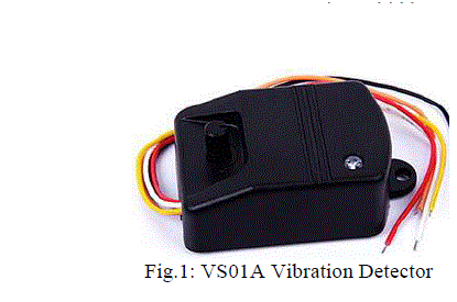
| The hardwares used in this study include an Arduino-Uno board, VS01A vibration detector, HC05 Bluetooth module, Breadboard, Wires, Resistors, Android smart phone. These were used along with standard web development softwares, Arduino IDE, and Android development platform. Each of these components and their role in our study are explained as follows. A. Vibration Detector: (VS01A): A vibration detector/sensor is used to receive real time vibrations sustained by the moving vehicle and convert it into electrical pulses (Fig.1). These electrical pulses are then sent to the Android smart phone by interfacing the vibration sensor circuit using an Arduino board. The vibration sensor has been tested in laboratory by tapping on or near it. The sensitivity of the sensor can be adjusted by turning the knob on the sensor. |
 |
| Mega2560 has many facilities for communicating with a computer, another Arduino, or other microcontrollers. The ATmega2560 provides four hardware UARTs for serial communication. The Arduino software includes a serial monitor which allows simple textual data to be sent to and from the board. The RX and TX LEDs on the board will flash when data is being transmitted. The Arduino Mega2560 can be programmed with the Arduino software and it is pre-burned with a boot loader that allows uploading new code to it without the use of an external hardware programmer. Once the unzipped Arduino IDE is downloaded, the Arduino board can be plugged in to the PC. Arduino senses the vehicle’s vibration environment by receiving input from vibration detector and then displays it on PC. |
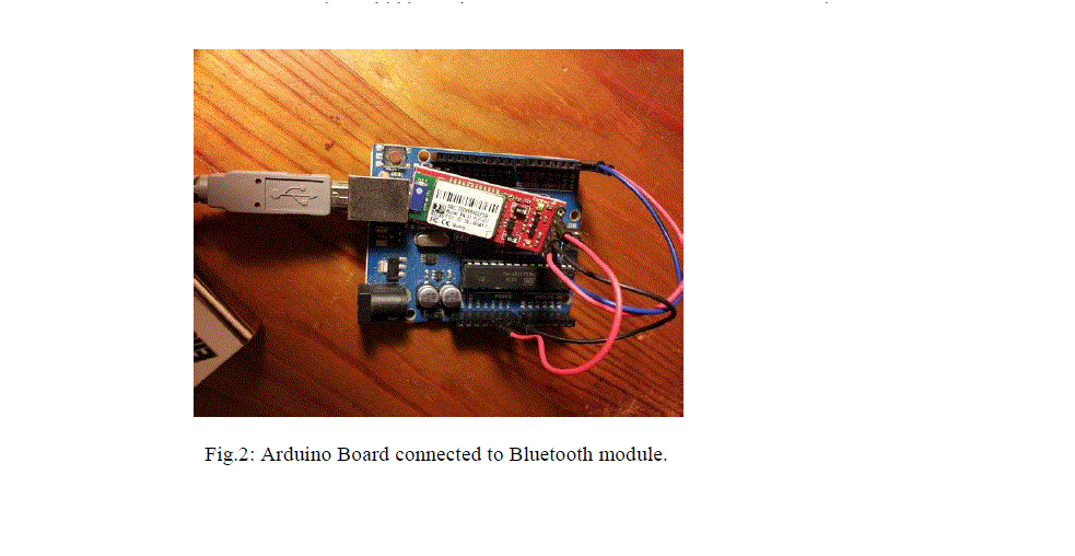 |
| C. Bluetooth Module: To connect the Arduino Board to the Android smart phone we connect a Bluetooth module to the Arduino board (Fig.2). Then the Bluetooth module has to be configured using AT commands to change the baud rate from default value to the value required for our application. Also the mode of the Bluetooth module is changed to Master from the default Slave mode using AT commands. |
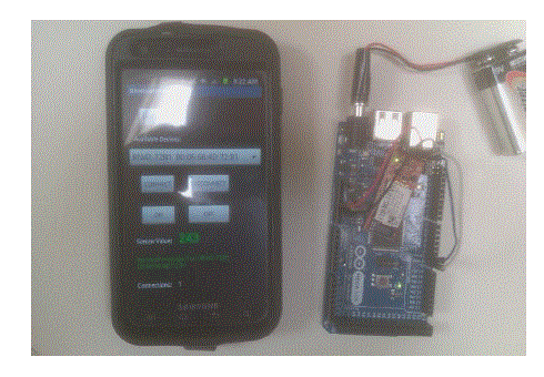 |
| Fig.3: Android smart phone connected to Arduino Board via Bluetooth |
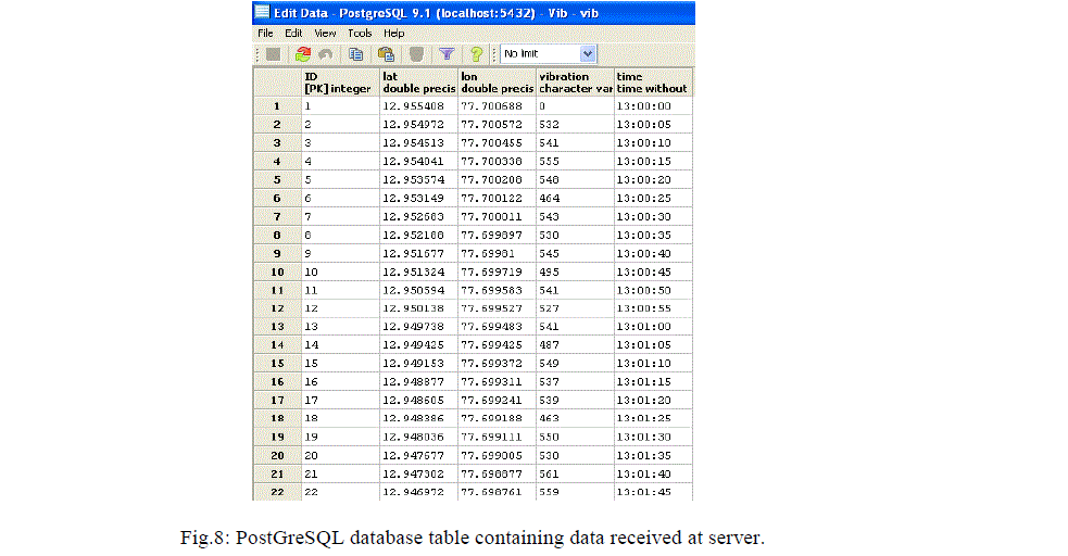
| D. Android Smart phone: The Android application running on the smart phone receives the values from the Arduino board through Bluetooth connection (Fig.3). A location provider is used to provide location coordinates of spatial entities, with the help of the phone’s built-in GPS. Then the combined information comprising of the sensor readings and location coordinates is sent through mobile GPRS to the Web server. E. GIS database: The information obtained is stored in a Web GIS database. The database we have used is PostGreSQL. The database stores latitude, longitude, vibration and time information for data retrieval or access in future (Fig.8). F. Internet Access: Once the information is available on the World Wide Web authorized users may access the information. |
 |
III.RESULTS AND DISCUSSIONS |
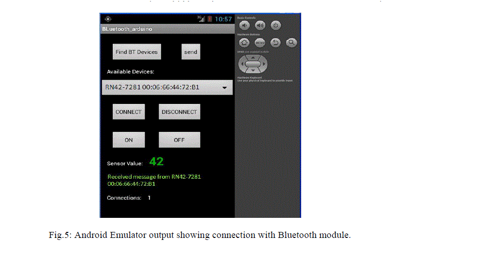
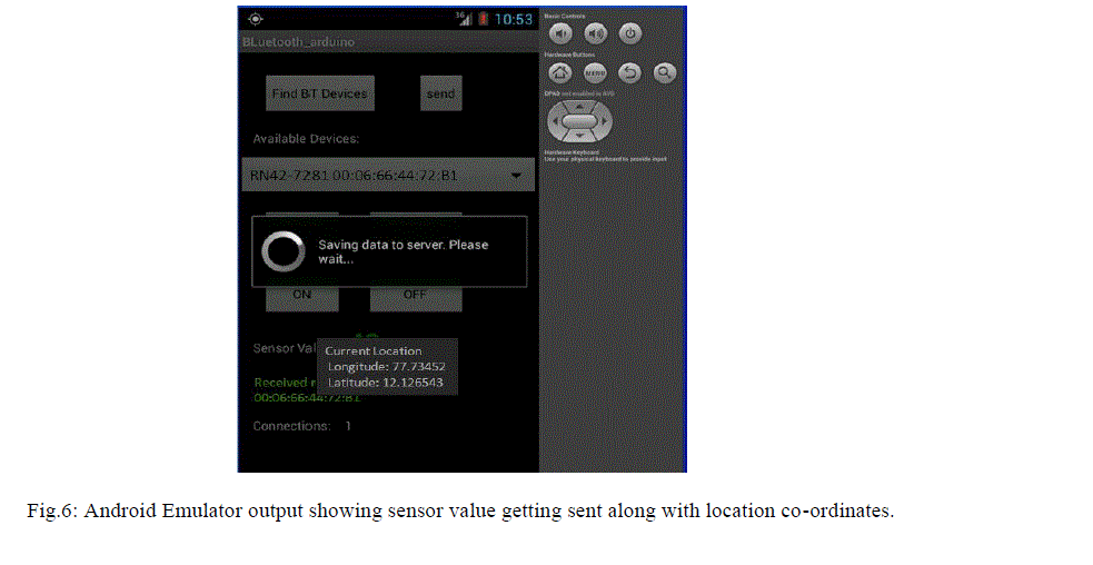
| Once the application is started the Bluetooth is switched ON in the Android smart phone. Then “Find BT Devices” button is clicked to detect Bluetooth devices in range. Once the Arduino board’s Bluetooth device is detected “CONNECT” button is clicked. The message below the sensor value turns green indicating the device is connected. Then “ON” button is clicked to start receiving the sensor value from the vibration detector connected to the Arduino board, and display it on the Android application (Fig.5). To start sending the stream of data received from the vibration detector (connected to the Arduino board), “Send” button is clicked. This starts the Alarm-Manager and the Location Manager in the Android application. The Location Manager retrieves the current location co-ordinates using the built-in GPS in the Android smart phone. The Alarm-Manager starts a timer for periodically executing a task. The task in our application is to post data to the server. Thus the vibration data is sent along with the location coordinates, over the mobile GPRS Internet to the web server (Fig.6). To stop receiving the stream of data from the vibration detector the “OFF” button is clicked. This also cancels the Alarm-Manager thereby preventing further posting of data to server. A threshold value was set in the Arduino side coding to make a LED glow and start a buzzer when the vibration exceeds the threshold value. This may serve as an alert to the Vehicle driver to prevent further damage to delicate equipment. |
 |
 |
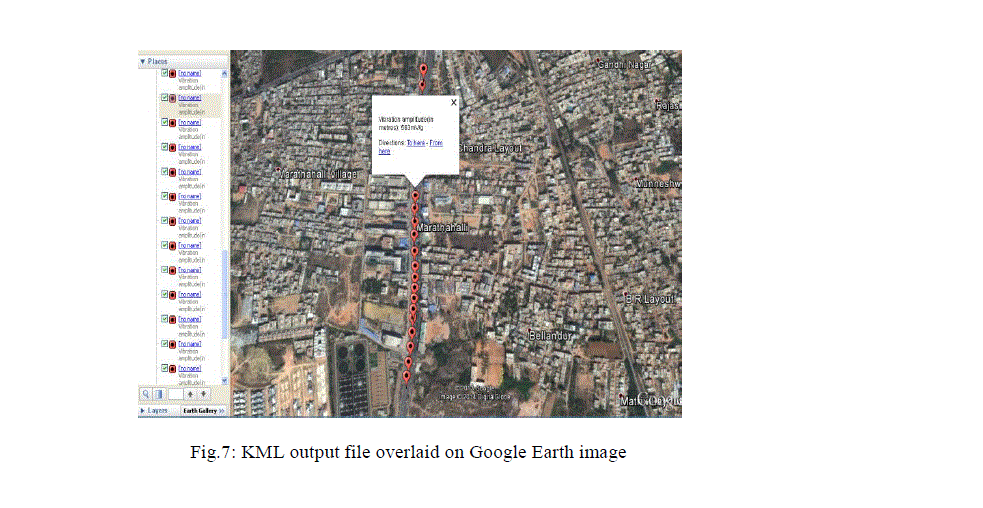 |
| The entries in the PostGreSQL database (Fig.8) on server side are then plotted on Google Earth Satellite Image by creating a KML (Keyhole Markup Language) file. The KML fetches the data from database and suitably plots it at corresponding location on the Google satellite Image with the help of a place mark. On clicking the place mark the description shows the vibration data sustained by the vehicle at that point (Fig.7). |
 |
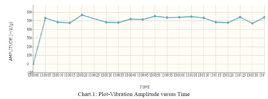
| Finally the amplitude of vibrations and the time at which it was received are plotted on a web page using jqplot (Chart- 1). This graph gets re-plotted every 5 seconds with new data from the database. |
 |
IV.CONCLUSION |
| The major outcome of the study includes the development of a Location Based Service application on Android smart phones and interfacing it to a vibration detector using an Arduino board for obtaining real-time vibrations. It is concluded that the vibrations are uniform with slight variations, indicating that the road is in good condition without any pot holes, and will not cause much damage to equipment being carried by the vehicle. The study gives useful information regarding selection of suitable routes to carry delicate equipment and also highlights the usefulness of Web-GIS in real time monitoring and vibration control of vehicle during transportation. |
ACKNOWLEDGEMENT |
| The authors are thankful to Dr. Uday Raj, Scientist/General Manager (RRSSC, ISRO) for his support in providing facilities and suggestions for improving this paper. |
References |
|