International Journal of Innovative Research in Science, Engineering and Technology
ISSN ONLINE(2319-8753)PRINT(2347-6710)
ISSN ONLINE(2319-8753)PRINT(2347-6710)
V.LakshmanaRao1, P.Satish2
|
| Related article at Pubmed, Scholar Google |
Visit for more related articles at International Journal of Innovative Research in Science, Engineering and Technology
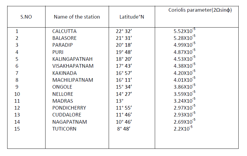
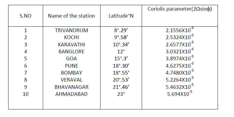
Sea breeze circulation very much dependent on only solenoidal term which accounts for differential heating between land and sea .The Coriolis force which always acts for perpendicular to the direction of motion is reflective force its changes the direction but not the magnitude. The Coriolis parameter is given by the expression 2Ω Sinф, here Ω is the angular velocity of the earth (7.2×10⁻⁵/s), and ф in the above expression denotes latitude. The Coriolis force is zero at equator and maximum (2Ω) at poles. For the three typical stations on the East coast of India Coriolis parameter is 4.38×10⁻⁵ Visakhapatnam 3.324 ×10⁻⁵ Madras and 2.2 × 10⁻⁵ for Tuticorin .The penetration will be more as we move south toward equator. A similar estimation of f (2Ω sinф) can be done for West coast the typical value for the stations Trivandrum 2.076×10- 5, Goa 3.799×10⁻⁵, and Bombay is 4.581×10⁻⁵. Theoretically speaking the peninsular India can be considering hypothetically as a triangle whose area reduce as one moves to the south .A situation arises at southern regions that two sea breeze fronts from west as well as East come in the opposite direction and both can be meeting on which case there will be more convection and this may be lead to thunderstorm activity are well known in the southern part of Tamilnadu and Kerala.
Keywords |
| solenoidal, Coriolis force, land and sea breeze, Thunder Storm activity. |
I. INTRODUCTION |
| Many of the investigators e.g., Jefferys (1922) had ignored the effects of Coriolis force, claiming that, the circulation is too small to be affected by earth´s rotation. However, in mid – latitude observational studies, has been shown that as the sea breeze circulation grows horizontally from the coast throughout the day, the sea breeze does turn to flow approximately parallel to the coast ,usually by late afternoon. This means that air particles within the circulation must be subject to the Coriolis acceleration of several hours. Bearing in mind typical sea breeze velocities of 5-10 ms-1 over a horizontal range of about 100km, an air would be in the sea breeze part of the circulation for only about 3 hours, probably not sufficient to account for the full veering effect on the wind. However, if the air particles rose at the sea breeze front and formed part of the return current they would still be under the influence of the Coriolis within the sea breeze circulation and thus promote further veering of both the surface sea breeze and the upper return currents. Ficher (1960) reported such veering of both the currents. Studies of Angel and Pack (1965), Hsu (1970) and Mizunia and Kakuta (1974) do reveal a closed circulation system of air flow in the vicinity of the coast.If there is sufficient moisture and instability available, the land breeze can cause showers or even thunderstorms, over the water. Overnight thunderstorm development offshore due to the land breeze can be a good predictor for the activity on land the following day, as long as there are no expected changes to the weather pattern over the following 12–24 hours. |
| If air particle in mid-latitudes originated from well outside the sea breeze circulation at sea, took part in the circulation for (say) 6 hours and then left the circulation inland , it is difficult to see how the circulation could turn through 90°to give a wind parallel to the coast. As we observe that the breeze does indeed veer this must mean that in latitudes 30°-60° at least it must be affected by the Coriolis force for about 6-12 hours. As most of sea breeze usually extends not more than 50 km land ward and seaward (land breeze).If the particle continues to be affected by the Coriolis force, it must remain within the circulation. Consequently evidence suggests that the sea breeze circulation is largely closed and that it is thus very closure that attributes significance to Coriolis .Greater Coriolis acceleration being reflective turn the sea breeze to the right in the Northern Hemisphere which means the sea breeze will not be able to penetrate deep in to the inland if the Coriolis acceleration is strong. The Coriolis parameter 2Ω Sinф varies with altitude Ω the angular velocity of the earth is constant and is equal to 7.2 x 10⁻⁵S-1. |
| The onset of the sea breeze and land breeze vary greatly from month to month and even to day to day, especially during the winter season. But in summer, it is easy and clear to identify the onset times. The sea breeze’s theoretical study is of practical interest and importance. The sea breeze circulation can be better explained by using circulation theorem developed by Bjerknes.V, in 1898 and later refined by Kelvin.Circulation is a parameter which measures the rotational tendency of a sample of fluid. Circulation is a parameter which measures the rational tendency of a sample of fluid. The rate of change with time of the circulation is important since it is involved in prognostication.In India several observational studies of sea breeze have been made in the past .The sea breeze on the west coast is known to penetrate as far as 180 km inland from sea (Ramanathan 1931) .Benerjee,et al (1975) have studied the sea breeze at Jagadalpur and pointed out that the sea breeze on the east coast could extend 150 km inland from shoreline.At Visakhapatnam the prevailing winds during the period February to September are predominant from southwest or west as a result of parallel isobaric pattern to the coastline with low pressure over land and high pressure over seaside .Due to the differential heating of land and sea surface in the midmorning hours,the pressure gradient will further be strengthened. During the period of Ocober to January and some days in the month of February,the low pressure over the sea and high pressure inland result in a wind from northeast quadrant. |
II. DATA AND METHODOLOGY |
| The Coriolis force is calculated using the relation: |
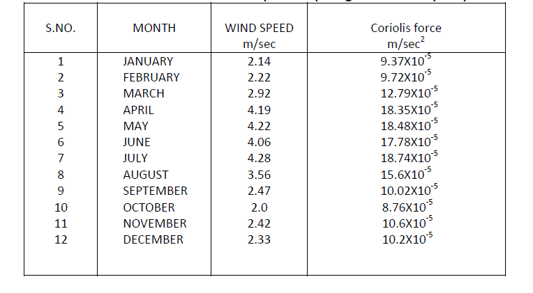
| D= v f, where D= Coriolis force, v = wind speed, f= Coriolis parameter =2ΩSinф, the angular velocity of the earth= 7.2 X10⁻⁵ s-1, ф is the latitude of the place of the study. In our case, it is Visakhapatnam. Therefore, the latitude of the Visakhapatnam city is 17° 43¹N.Coriolis parameter for Visakhapatnam=2Ω Sinф =2 x 7.2 x10-5 xSin17° 43’= 4.38 x10- 5 .Similarly we can find the Coriolis parameters of east coast and west coast stations. Here we calculate the Coriolis force using mean wind speed and maximum wind speeds of all the months of the Visakhapatnam during the year 2012. And here we are studying about thunder storm activity related to sea and land breezes close and continuous monitoring of lightning activity may be considered as a need of present day scientific studies.The cold air from the sea meets the warmer air from the land and creates a boundary like a shallow cold front. When powerful this front creates cumulus clouds, and if the air is humid and unstable, cumulonimbus clouds, the front can sometimes trigger thunderstorms.The thunder storms mainly originate over the heated island masses that heats up the air mass above it and initiates convection and occur mainly in the tropical belt. If the wind is relative calm then the sea breeze can move will inland but with only scattered thunderstorms occurring about 1/3rd of the way across the peninsula |
| Light west wind (5-10 mph) keeps the sea breeze front confined to the eastern coast but also makes for more widespread thunderstorms along the boundary. Stronger west winds prevent can the sea breeze front from moving onshore, or forming at all, so no thunderstorms will occur. With prevailing east winds, they actually help push the sea breeze front and thunderstorms as much as half way across the peninsula. Air flowing toward the land creates a boundary called a sea breeze front, which frequently results in heavy rains and thunderstorm activity. Sea breezes are most significant during the spring and summer when daily heating is at a maximum. |
III. RESULTS AND DISCUSSIONS |
| The table No.I gives the values of Coriolis parameter at different stations on the East Coast of India. The stations were arranged from north to south, i.e., from high latitude to low latitude .From the table it can be easily seen that the Coriolis parameter varies directly with latitude. It is high at the Northern most point on the East coast of India namely Calcutta. The Coriolis parameter is minimum at Tuticorn.From the table, it is also evident that the sea breeze front can penetrate more inland at Tuticorn compared to all the other station North of it. The penetration decreases as the Coriolis parameter increases. The Coriolis parameter at selected stations on the entire west coast was calculated. It is high at the northern most point on the west coast of India namely Ahmadabad. The Coriolis parameter is minium at Trivandrum. The sea breeze can penetrate more in land at Trinvandrum compared to all others stations north of it. |
| It is observed that Coriolis force is maximum in the month of July and minimum in the month of October, when the mean climatologically wind speeds are taken into consideration. However Coriolis force is maximum in the month of April and minimum in the month of October when only maximum in the month of October when only maximum wind speeds are considered. The Coriolis force is calculated for Visakhapatnam using both mean wind speed and maximum wind speed and the tables 3. and 4 show these values respectively. |
IV.SUMMARY AND CONCLUSIONS |
| The effect of Coriolis parameter discussed for the entire East and West coast of India. The effect of Coriolis force is discussed in detail for Visakhapatnam. The urbanization also plays its own significant role not only in the development of local circulation but also in the air quality. Synoptically speaking, the NE monsoon synoptic winds which blow from NE to SW oppose the local sea breeze circulation. It is interesting note that the SBI is low in winter months. This clearly indicates that sea breeze is strong and flushing action is strong in winter. During the monsoon months the land sea breeze thermal contrast is less, which results in a mild sea breeze that is reflected in the high values of sea breeze index in July |
 |
 |
 |
References |
|