International Journal of Innovative Research in Science, Engineering and Technology
ISSN ONLINE(2319-8753)PRINT(2347-6710)
ISSN ONLINE(2319-8753)PRINT(2347-6710)
Arockia Prince J1, Madhan Kumar2, Vanitha L3
|
| Related article at Pubmed, Scholar Google |
Visit for more related articles at International Journal of Innovative Research in Science, Engineering and Technology
With the construction of mobile communication network system, the need of building an integrated network management system based on specialized network management using GIS technologies become more and more necessary. By analyzing the current status of mobile communication network management system, this paper proposes that using ArcGIS, Java, Flex and other technologies to implement the integrated network management system. Then it explains key technical issues in the system implementation. Finally, this paper summarizes the practical application to Sichuan Branch of China Mobile Communications Group Co, and offers a prospect of the developing direction
Keywords |
| GIS, MMS, SSL Encryption; Wireless Mobile Solution |
INTRODUCTION |
| In recent years, with the rapid development of mobile communication, a large number of communication facilities have been put into operation. The variety of mobile communications appears, amount of data comes from resource management, network maintenance, communications, construction, management decisionmaking and a variety of application fields. With the development of business, some issues related with the spatial location is often encountered [1].With the expansion of network scale and the severe market competition, Supporting capacity requirements of network management system (hereinafter referred to as NMS) are increasing due to various demands. Based on centralized maintenance requirements, timely and intuitive support tools which can reflect the status of the network is needed. Geographic Information System (hereinafter referred to as GIS) as an important tool for acquisition, processing, management and analysis of geospatial data has been widely used [2]. GIS meets the needs of management level by achieving full control of the network: achieving the precise location of network resources, clearly marking sphere of influence of the network failures, managing and analyzing the customer complaints, analyzing network optimization regionalization, and presenting the network quality cloud map. The implement of GIS technology, not only can visualize the management of traditional resource, but also can work as the infrastructure for the development of the application of the on-upper application. With it, the entire network can provide real-time operational status of the management, including: network performance, alarm, complaints, etc., and can. |
NETWORK COLLABORATIVE TRANSMISSION MODEL |
| This paper puts forward the network collaborative transmission model which consists of GPS, data center (also as JabberIXMPP Server), differential base station, PDA combined together with GPRS (General Packet Radio Service), |
Bluetooth and other network. |
| 1) PDA and AutoPC: Several PDA constitutes a PDA group in the network collaborative transmission model. In the PDA group, every PDA can communicate and collaborate with each other. So it can improve work efficiency. In addition, PDA group can achieve different functions by initializing different software in them. In addition, AutoPC has the similar situation to PDA in the network collaborative model |
| 2) GPS network: GPS network is a worldwide spacebased global navigation satellite system formed from a constellation of 24 satellites and their ground stations. It is maintained by the United States government, and it can provide reliable location and time information in all weather and at all times. GPS network is freely accessible by anyone with a GPS receiver. In this paper, GPS network is used to provide reliable location service through the differential analysis. |
| 3) JabberlXMPP Server: An Jabber/XMPP server provides basic messaging, presence, and XML routing features [1]. There are several selections to construct Jabber/XMPP server, such as EJabberd, Prosody, Jabberd, Tigase, DJabberd, Openfire etc. Through comparative analysis, we select Openfire to construct JabberIXMPP server and run Jabber/XMPP service either over the Internet or on a local |
A. GIS and WebGIS |
| The geographic information system is a technical system of geography information science, using the theories and methods of system engineering and information sciences to gain, store, manage, analysis and utilize spatial information with the support of computer software and hardware [1]. GIS is widely used and has become a tool of city information management, urban planning, city infrastructure management, traffic control and so on. Meanwhile GIS has entered into some areas such as the military strategy analyzing, commerce people's daily life, thus its social position has been obviously improved. GIS is recognized as the pillar industries of 21st century. Now WebGIS is the mainstream development and application of GIS technology. WebGIS is used as the provider of spatial data browse, inquiry and analysis. The application structures of WebGIS mainly have C/S and B/S: for the C/S structure, part of application software must be deployed in the client side, and the request of client is completed by the cooperation of the client side and server side, while for the B/S structure, the requests of user is processed in the server side, and there is no need to deploy system software in the browser side. Currently, the applications of WebGIS are mainly concentrated in network (Internet or Intranet). Along with the development of wireless communication technology as well as the increasing needs of space information, the insufficiencies of WebGIS based on Internet or Intranet gradually emerge, mainly in the following several aspects: |
| • The flexibility in applications is bad: Traditional WebGIS applications must rely on network, once customers are unable to access network, they may not be able to enjoy the services of WebGIS; |
| • Mobility is bad: Users of traditional WebGIS cannot move at will in using of WebGIS; |
| • Limited applications areas: Traditional WebGIS is mainly used to spatial information gather, memory, management and analysis and so on. How to make GIS provide more convenience for the populace is a question with which GIS research always pondered. In view of these insufficiencies, we use wireless technologies and equipments as well as WebGIS technology, realize the integration of wireless communication equipment, wireless communication network, Internet technology as well as WebGIS technology, and make GIS application more widely and nimbler. |
B. The Integration of Wireless Network and GIS |
| In mobile GIS, information transmission between mobile terminals and GIS is completed through the wireless method. Information sent by mobile terminals is transferred by wireless network, while data information transmission of GIS is through Internet. How to realize the integration of GIS and mobile terminals, the connection of wireless network and Internet is a key factor. Now the wireless network mainly uses the WAP model and WWW model [2] in doing so. WAP, namely wireless application protocol, is a group of protocols for realizing the connection of the mobile equipments and Internet. The WAP technology has realized the connection of mobile communication systems and data communication systems perfectly, and users can connect the mobile equipments with Internet perfectly anytime and anywhere, without considering the type of network, network architectures, operation business services as well as terminal devices [3]. How to take advantage of WAP and make connection with GIS is one key technology in realization the integration of GIS and wireless network. In WAP model, we always make protocol transformation between WAP and TCP/IP, and there is also decoding and encoding processing of information in order to reduce the size of information. This model is mainly used in modern 4-G wireless topology secure mobile telephones. The WWW model is mainly used in PDA (Personal Digital Assistant). This mode uses the same technology as that of Internet. The WWW model has no protocol transformation since TCP/IP protocol is used in terminals. Now with the enhancing of the hardware of PDA and the ability of wireless network, applications of this model are widespread [3]. WAP network is mainly composed of three parts, namely WAP gateway, WAP mobile telephone and WAP content server. WAP gateway is the information translator and bridge of GSM network and World Wide Web; there is massive information stored in WAP content server, and the information can be inquired, browsed and so on by users. In WebGIS integrated with wireless communication networks, we fully take advantage of GIS and wireless network. In WAP model, a WebGIS server is connected with WAP server of wireless network. Requests of users are transformed into TCP/IP-based information, and then the information is transferred from WAP server to GIS server. The WebGIS server processes the requests and sends the procession results to WAP server, and the protocol is transformed from TCP/IP to WAP by WAP gateway before sending to users. As to WWW wireless model there is no need to transform the protocol, and GIS server can be viewed as a node of wireless network. |
C. The Integration of GPRS and GIS |
| GPRS is a new kind of data service of GSM, providing a connection between mobile users and data network, and also providing high speed wireless IP and X.25 connection service as well for users. GPRS network is based on the existing GSM network. That is to say, adding such functional node as GGSN (Gateway GPRS Supporting Node), SGSN (Serving GSN) to GSM network. GSN is the most important node in GPRS network. GSN has a mobile route management function, and can connect any type of the data network, and may connect to GPRS register. GSN can complete data format transformation and data transfer between mobile terminals and any kind of network. GSN has two kinds of types: One kind is SGSN (Serving GSN), another is GGSN (Gateway GSN or the GPRS router). The main function of SGSN is recording the position information of mobile terminals and transferring and receiving packet data information between mobile terminals and GGSN. GGSN mainly functions as network gateway, can connect with many kinds of different data network, such as ISDN, PSPDN and LAN and so on. GGSN can make protocol transformation of packet data packages of GPRS in GSM, in order to transmit these data packages to farend of TCP/IP or X.25 network. In the transmission of GIS spatial information through the using of GPRS, the information sent by mobile users is firstly carried on conversion of protocol before sent into Internet, and then the information is sent to GIS server for processing through Internet. |
DESIGN AND IMPLEMENTATION |
| In theory, for the terminal in mobile GIS has no fixed public network IP address, and the current communication links of mobile GIS is mainly GPRS network, so we first should resolve problems of firewall traversal and NAT traversal to establish and maintain TCPIIP network and/or UDP connections traversing network address translation gateways. Furthermore, as cooperativity in Mobile GIS needs to be achieved through network communications, so it should have to construct a good platform for data transmission. According to the work flow and functions mentioned above, we have firstly designed and implemented a network collaborative transmission platform as follows: |
A. Software Developing Environment |
| According to the work flow and functions above, we have firstly developed data transmlSSlOn platform in PC environment based on the open-source C++ libjingle library and ACE (Adaptive Communication Environment), using Microsoft Visual studio 2005. Then we transplanted it into the WinCE embedded platform. Libjignle library is a collection of open-source C++ code and sample applications that enables one to build a peertopeer application [2]. Libjignle library was launched by Google company in 2006. And the famous instant messaging software, Gtalk, is just developed based on it. It is worth mentioning that libjingle library has not only achieved most functionality of the Jabber/XMPP protocol, but also has good extensions to better support network transmission applications. ACE is a freely available, open-source object-oriented (00) framework that implements many core patterns for concurrent communication software [3, 4]. ACE is targeted for developers of high-performance and real-time communication services and applications. It simplifies the development of 00 network applications and services. |
B. Design and Implementation of the Network Collaborative Transmission Model |
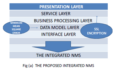 |
| • Interfaces between integrated NMS and specialized NMS. |
| • Data model layer implements the Unified Modeling of NMS data and GIS data is in fig a. |
| • Business processing layer implements the business logic functions, such as system security management, service scheduling, etc .. |
| • Service layer provides services for the calling of client side. |
| • Presentation layer presents Geographic Information Locator, information aggregation and real-time information presentation for the NMS using presentation technology, including GIS visualization technology. |
| • Secure Socket Layer(SSL) Encryption The client sends the server the client's SSL version number, cipher settings, other information for communication using SSL. |
| • The server responds the client the server's SSL, session-specific data, and other information that the client needs to communicate with the server over SSL. The server requests the client's certificate. |
| • The client uses the information sent by the server to authenticate the server (see Server Authentication for details). If the server cannot be authenticated, the user is warned of the problem and informed that an encrypted and authenticated connection cannot be established. If the server can be successfully authenticated, the client proceeds itself. |
| Using all data generated in the handshake thus far, the client (with the cooperation of the server, depending on the cipher being used) creates the pre-master secret for the session, encrypts it with the server's public key (obtained from the server's certificate, sent in step 2), and then sends the encrypted pre-master secret to the server. |
| • If the server has requested client authentication (an optional step in the handshake), the client also signs another piece of data that is unique to this handshake and known by both the client and server. In this case, the client sends both the signed data and the client's own certificate to the server along with the encrypted pre-master secret. |
| • If the server has requested client authentication, the server attempts to authenticate the client (see Client Authentication for details). If the client cannot be authenticated, the session ends. If the client can be successfully authenticated, the server uses its private key to decrypt the premaster secret, and then performs a series of steps (which the client also performs, starting from the same pre-master secret) to generate the master secret. |
| • Both the client and the server use the master secret to generate the session keys, which are symmetric keys used to encrypt and decrypt information exchanged during the SSL session and to verify its integrity (that is, to detect any changes in the data time it is received over the SSL connection). |
| The client sends a message to the server informing it that future messages from the client will be encrypted with the session key. It then sends a separate (encrypted) message indicating that the client portion of the handshake is finished. |
 |
 |
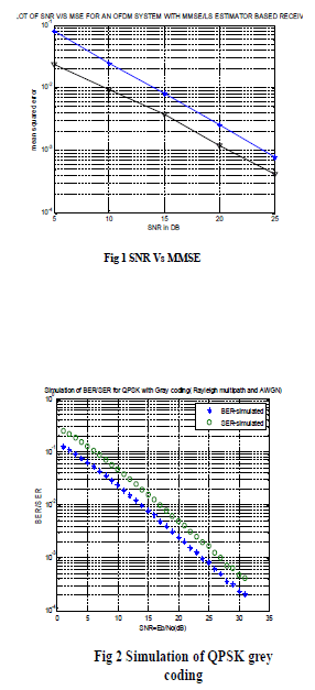
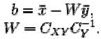
| This regards the error reduction techniques Under some weak regularity assumptions,[1] the MMSE estimator is uniquely defined, and is given by Fig1 |
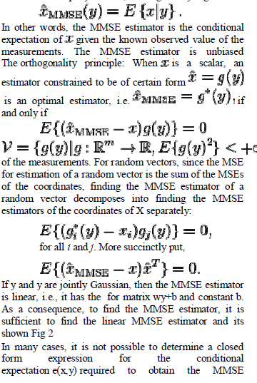 |
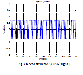
| estimator. Direct numerical evaluation of the conditional expectation is computationally expensive, since they often require multidimensional integration usually done using Monte Carlo methods. In such cases, one possibility is to abandon the full optimality requirements and seek a technique minimizing the MSE within a particular class of estimators, such as the class of linear estimators. Thus we postulate that the conditional expectation of x given y is a simple linear function of y, e(x,y)=wx+t, where the measurement y is a random vector,w is a matrix and b is a vector and is implemented by QPSK in fig3. The linear MMSE estimator is the estimator achieving minimum MSE among all estimators of such form. Such linear estimator only depends on the first two moments of the probability density function. So although it may be convenient to assume that x and y are jointly Gaussian, it is not necessarily to make this assumption, so long as the assumed distribution has well defined first and second moments.The expression for optimal b and w is given by |
 |
| Three essential components are needed to fully take advantage of mobile GIS: Global Positioning System (GPS), rugged handheld computers (e.g. PDA), and GIS software. In my mobile GIS system, several key modules are designed as follows: |
| 1) Data Structure: Due to limited resources of mobile devices, for example, the memory capacity of contemporary PDA is in range of 128 MB, the processing capability is in the range of 600 MHz, so data structure needs to be specially designed to support effectively mobile GIS applications. In this paper, based on OpenGIS Simple Features Specification, we have designed the spatial data structures according to specific applications of land verification in mobile GIS platform. 2) SeriallBluetooth communication module between GPS receiver and PDA: Currently, most GPS receiver and PDA have supported SeriallBluetooth communication. In essence, serial communication and Bluetooth communication can be unified to serial communication for they have the same communication mechanism. In our research, we adopt the ACE Task class to construct SeriaVBluetooth communication module between GPS receiver and PDA. The ACE_Task class is often used to implement multithreaded processing in ACE applications. In the end, this module can be designed to achieve bilateral communication between PDA and GPS receiver. |
| 3) Spatial information acquisition module: Acquisition of spatial information is its basic function of this module. In our research, we use a C++ open source library OGR (OpenGIS Simple Features Reference Implementation), which is part of the GDAL (Geospatial Data Abstraction Library) library, to realize the function. It is worth mentioning that spatial information acquisition module is one of the most important modules in our research because acquisition of spatial information is the prerequisite to realize network collaborative transmission. In the implementation of the module, we have used several classes and functions of OGR, such as function OGRDataSource::GetLayerO which is to get pointer of target layer OGRLayer needed to be created, function OGRFeature::SetGeometryDirectlyO assigning geographic coordinates to the newly created polygons, and function OGRFeature::SetFieldO assigning attribute informations to the newly created polygons, etc. JabberlXMPP server and clients: It can be shown as follows: |
| 1) Installing and configuring JabberlXMPP server: In this paper, we select Openfire to construct JabberIXMPP serverand run Jabber/XMPP service either over the Internet or on a local area network. |
| 2) Configure Jabber/XMPP server: Once you have installed Openfire, you can start the task launcher and click on the Start button, then Openfire will display admin console listening at http://127.0.0.1:9090. So one can use the Launch Admin button in admin console interface to start the web interface.Then Openfire will be automatically configured and you can use the web-based admin console to administer the server. |
| 3) Jabber/XMPP client development using Gloox: Gloox is a stable, extensible library for the development of modern using Jabber/XMPP clients and components, written in clean ANSI C++. In my research, we use Gloox library to develop and realize communication among PDAs. |
| 4) Data transmission channel: In this paper, we adopt ICE mechanism based on libjingle library to establish links between peers and apply sig/slot mechanism to send and receive messages between peers. In order to provide as much as possible potential links for other computers, three kinds of local candidate links (i.e. LAN IP address, public network IP address, Relay IP address) can be generated based on libjingle library. Libjingle can maintain writability of the channel by sending STUN (Simple Transversal of UDP through NATs) packets from time to time, and ensures the firewall and NAT addresses effective binding. |
| System integration: In my present study, system integration is divided into three parts of data integration, hareware integration and software integration. |
| 1) Data integration: XMPP uses streaming XML over a long lived TCP connection for communication. While XMPP provides a generalized, extensible framework for exchanging XML data, various data in the field of land verification, such as raster data, vector data etc., should be unified into highlevel structured XML statements for communication. To start communicating, a client would send opening XML tags, then parses them into original format to meet the demand. |
| 2) Hardware integration: A variety of harewares (i.e. XMPP server, PDA, SIM card, GPS receiver) are organically integrated into a whole through physical hardware interface and cable/wireless network. The goal is to implement organic coordination and achieve overall optimization of the system. |
| 3) Software integration: Software integration [6] is the process of enabling two or more software systems to talk to each other by making common data available to each system and facilitating the exchange of this data between the systems. Using software component technologies in this paper, we package network collaborative transmission platform into DLL (Dynamic Link Library), which is developed as a separate component to provide interface for the field data acquisition of land verification in the process of software integration. This method has the advantage of reducing the coupling of software and improving software reusability. |
APPLICATION OF COLLABORATIVETRANSMISSION |
| The land verification process is an essential step to determine the land attribute of occupancy. During the course of field operation for land verification, it will often meet complex terrain or have large workload, and then it will cause low efficiency in traditional stand-alone mode of operation. In view of this, we adopt collaborative working mode and select a land verification system using mobile GIS technology as an example to test efficiency of collaborative transmission. In the application, a 2 kilometers long river which has the drainage area of about 10000 square meters is adopted as the test object [7]. The river locates in Beichen district, Tianjin city of China. Obviously, verifying the river area must be a time-consuming task if one applies traditional stand-alone mode of operation. So we arrange people on both sides of the river to carry out collaborative work using Mobile GIS system. |
| 1) GPS points collected on bank A: Due to the contour line of bank A is relatively straight, then only five GPS points are collected based on feature point of bank A. |
| 2) GPS points collected on bank B: For the reason of the contour line of bank B is full of twists and turns, there are of a more GPS points needed to be collected. In the application, it has collected more than seventeen GPS points of bank B to meet the demand |
| 3) GPS points on bank A and B: GPS points of bank A are transmitted to PDA which contains GPS points of bank B by Jabber/XMPP network collaborative transmission platform. Then GPS points of bank A and B are all shown in a same PDA. It can be seen in figure 2(c). |
| 4) Construction of polygons: After the three steps, all the GPS points of bank A and B can be linked to construct a polygon using a Mobile GIS system, and then can calculate the river area. |
IMGIS (INTEGRATED MOBILE GIS) |
| A. System Structure |
| IMGIS contains all the current wireless communication protocols in order to meet the need of multi-purpose applications of users. IMGIS makes an extension of the applications of WebGIS to wirelesscommunication technology- based applications. Users can enjoy spatial information services of GIS anytime and anywhere by using IMGIS. |
| The application structure of IMGIS adopts maturer B/S (Browser-Server) pattern. Using the SQL Server software as database software to manage the information of spatial and users in IMGIS. The GIS server mainly processes spatial information; and the application server mainly matches and processes users information. As shown in the Fig.1, IMGIS is mainly composed of Session Manager, Content Manager, Device Awareness, Manager, GIS Server, Database Engine and the spatial database. Session Manager, Content Manager, Device Awareness and the Manager are mainly deployed in the application server, and GIS Server and Database Engine are deployed in the GIS server. Session Manager: Mainly completes the connection and disconnection of communication between users and the system. Manager: The Manager works under the condition of the establishment of connection of the communication. Manager mainly completes the management of the system business log, the authentication, the authorization, the accounting and other tasks such as the management of DNS, NMS and Billing system and so on. |
| Device Awareness: This part mainly realizes the wireless equipment recognition and matches the information with the registered devices according to the information sent by user. Content Manager: This part translates user information into invoking request, sends this request to GIS Server and transmits back the processing result. GIS Server: This part carries on the processing work of spatial information according to user's request, including data information processing (such as editing), map display control, information inquiry, information analysis and statistics. This is the core service of overall system. Database Engine: This part realizes the connection of GIS Server and the spatial database. The processing and operation of spatial information need accessing to the spatial data information stored in spatial database, and all the work is mainly completed through this part (Database Engine) of IMGIS. Spatial Database: All the spatial data information of IMGIS is stored in the spatial database, spatial data information mainly including attribute information, position information and spatial relation information. |
DEVELOPING AND REALIZATION OF IMGIS |
| A. Developing Description of the IMGIS |
| The developing of IMGIS follows the basic principle of software engineering and is managed with staged life cycle projection. All the development activities observe the RUP unification software developing. We use the Rose software of Rational Software Corporation to carry on the demand analyzing and modeling. And the code programming and managing are done through the Integrated Development Environment (IDE) of Microsoft Corporation. The development of IMGIS uses the objectoriented method to consider and to solve all questions from beginning to end, the object-oriented method manifests in such important stages as demand analyzing, designation, coding and testing of the system. All the parts of the IMGIS are completed through the use of COM technology of Microsoft Corporation. |
| B. System Realization |
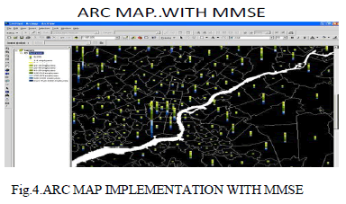 |
| IMGIS is completed in the programming platform of dot net of Microsoft Corporation in the windows serials operation with the Arc Map is shown in above fig 4 system. IMGIS integrated wireless communication technology and WebGIS technology, mainly realize the following functions: |
| • Location based service: A system user can use wireless equipments to inquire the position of his own. In the inquiring procession position information of the user is accessed through GPS of wireless equipments, and equipments send a request (the position of the user is included in) of digital map to system server, the server carries on processing, sending the result (surrounding digital map center at the position of user) to the user in the form of JPG image, this JPG image can be shown in wireless equipments; |
| • Alarming: A system user can use wireless equipments to alarm. The position information of the person who sends the alarm can be shown in a digital map in the system server. And the location information can beIII. IMGIS (INTEGRATED MOBILE GIS) |
| A. System Structure |
| IMGIS contains all the current wireless communication protocols in order to meet the need of multi-purpose applications of users. IMGIS makes an extension of the applications of WebGIS to wirelesscommunication technology- based applications. Users can enjoy spatial information services of GIS anytime and anywhere by using IMGIS. The application structure of IMGIS adopts maturer B/S (Browser-Server) pattern. Using the SQL Server software as database software to manage the information of spatial and users in IMGIS. The GIS server mainly processes spatial information; and the application server mainly matches and processes users information. Session Manager, Content Manager, Device Awareness, Manager, GIS Server, Database Engine and the spatial database. Session Manager, Content Manager, Device Awareness and the Manager are mainly deployed in the application server, and GIS Server and Database Engine are deployed in the GIS server. |
| Session Manager: Mainly completes the connection and disconnection of communication between users and the system. |
| Manager: The Manager works under the condition of the establishment of connection of the communication. Manager mainly completes the management of the system business log, the authentication, the authorization, the accounting and other tasks such as the management of DNS, NMS and Billing system and so on. |
| Device Awareness: This part mainly realizes the wireless equipment recognition and matches the information with the registered devices according to the information sent by user. |
| Content Manager: This part translates user information into invoking request, sends this request to GIS Server and transmits back the processing result. |
| GIS Server: This part carries on the processing work of spatial information according to user's request, including data information processing (such as editing), map display control, information inquiry, information analysis and statistics. This is the core service of overall system. Database Engine: This part realizes the connection of GIS Server and the spatial database. The processing and operation of spatial information need accessing to the spatial data information stored in spatial database, and all the work is mainly completed through this part (Database Engine) of IMGIS. |
| Spatial Database: All the spatial data information of IMGIS is stored in the spatial database, spatial data information mainly including attribute information, position information and spatial relation information. |
DEVELOPING AND REALIZATION OF IMGIS |
| A. Developing Description of the IMGIS |
| The developing of IMGIS follows the basic principle of software engineering and is managed with staged life cycle projection. All the development activities observe the RUP unification software developing. We use the Rose software of Rational Software Corporation to carry on the demand analyzing and modeling. And the code programming and managing are done through the Integrated Development Environment (IDE) of Microsoft Corporation. The development of IMGIS uses the objectoriented method to consider and to solve all questions from beginning to end, the object-oriented method manifests in such important stages as demand analyzing, designation, coding and testing of the system. All the parts of the IMGIS are completed through the use of COM technology of Microsoft Corporation. |
| B. System Realization |
| IMGIS is completed in the programming platform of dot net of Microsoft Corporation in the windows serials operation system. IMGIS integrated wireless communication technology and WebGIS technology, mainly realize the following functions: |
| • Location based service: A system user can use wireless equipments to inquire the position of his own. In the inquiring procession position information of the user is accessed through GPS of wireless equipments, and equipments send a request (the position of the user is included in) of digital map to system server, the server carries on processing, sending the result (surrounding digital map center at the position of user) to the user in the form of JPG image, this JPG image can be shown in wireless equipments; |
| • Alarming: A system user can use wireless equipments to alarm. The position information of the person who sends the alarm can be shown in a digital map in the system server. And the location information can be sent to police in the form of short messages or JPG images; |
| • Route analysis: A system user can carry on route inquiries and analyses, the server processes user's requests, and then sends the result in form of JPG image to the user. |
ACKNOWLEDGMENT |
| I wish to thank to our beloved Principal Dr. V.Srinivasa Raghavan M.E, Ph.D., for the facilities made available for progress and completion of this project. I express my sincere thanks to ourProject Coordinator Mrs.L.Vanitha B.E, M.Sc,M.Phil, M.E,M.C.A (Ph.D), also Dr.L.Madhan Kumar M.E.,Ph.D for her constant encouragement and valuable suggestions during the project review.. |
References |
|