International Journal of Innovative Research in Science, Engineering and Technology
ISSN ONLINE(2319-8753)PRINT(2347-6710)
ISSN ONLINE(2319-8753)PRINT(2347-6710)
P. Senthilkumar1, J.Nithya2, S.Suresh Babu3
|
| Related article at Pubmed, Scholar Google |
Visit for more related articles at International Journal of Innovative Research in Science, Engineering and Technology
Assessment of groundwater vulnerability using DRASTIC model in GIS environment has become more widespread for effective groundwater resource management. A study was carried out in Krishnagiri district, Tamil Nadu, India to develop an empirical DRASTIC model to identify the vulnerability owing to groundwater contamination with increasing population, industrialization and agricultural activities. The most important factors that control the groundwater potential are depth of water, rainfall, aquifer media, soil media, topography, impact of vadose zone and hydraulic conductivity of the aquifer. Estimation of DRASTIC Index involves multiplying each parameter weight by its rating corresponding to its study area and summing the total. Based on DRASTIC index values it was observed that the vulnerability in the study area falls between low vulnerability to high vulnerability. The results provide important information for the local authorities and decision making personals for effective management of groundwater resources.
Keywords |
| Groundwater, vulnerability, DRASTIC model, GIS, Remote Sensing |
INTRODUCTION |
| Water is the basic element of social and economic infrastructure and is essential for healthy society and sustainable development. 97% of Earth’s water is in the form of saline water and only 3% of fresh water is available [1]. It is scientifically proved that 68.7% of fresh water is found to be stored in the form of glaciers and icecaps and 30.1% is available in the form of groundwater. Groundwater is one of the valuable earth’s renewable resources for human life and economic development, which occur as a part of hydrologic cycle. Amongst the natural water resources, groundwater forms an invisible component of the system. In last 50 years it is observed that development of groundwater resources is unpredictable. An estimated 2 billion people worldwide rely on aquifers for drinking water supply. The annual utilizable groundwater resources in India are estimated as 428 km2 per year [2]. This accounts for about 80% of domestic water requirement and more than 45 % of the total irrigation requirements of the country. In recent years, the utilization of groundwater is increasingly at a faster rate which leads to the depletion of groundwater. On the other hand contamination of groundwater due to various anthropogenic sources is growing at a faster rate, so that it is no longer fit for use. This resulted in increasing pressures on available groundwater resources in terms of both quality and quantity. The quality of groundwater depends on a large number of individual hydrological, physical, chemical and biological factors. Prevention of contamination is therefore critical for effective groundwater management. To properly manage and protect the resource, it is therefore important to determine areas with more aspects of vulnerable to contamination. Groundwater vulnerability is considered an intrinsic property of groundwater that depends on its sensitivity to humans and natural impacts and can be defined as the possibility of percolation and diffusion of contaminants from surface of the earth into the groundwater system [4]. Vulnerability zone maps have become an essential tool for groundwater protection and environmental management [5]. Several methods have been proposed for vulnerability assessment of aquifers. Hence, in this paper presents a standardized system called DRASTIC approach is used, which incorporates physical characteristics of any area into a methodology which can be used to evaluate the groundwater vulnerability of any hydrogeologic setting. |
STUDY AREA |
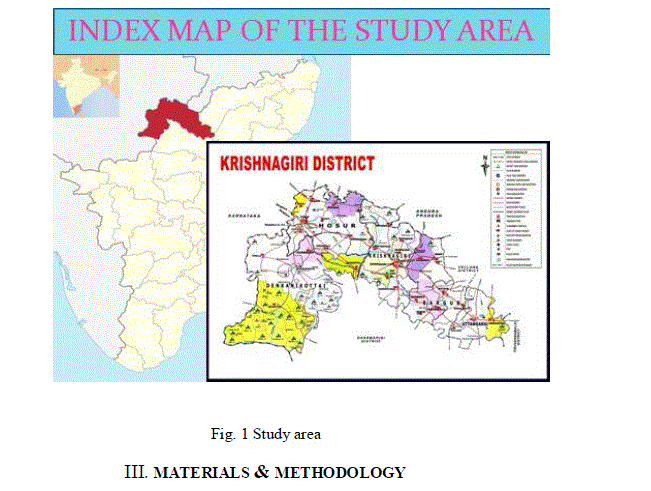
| Krishnagiri is an important district in the part of Tamilnadu. The study area falls between North latitudes 12° 16' N & 12° 88' N and East longitude 77° 50' E & 78° 55' E (Fig. 1) and covers an area about 5143 km2. Krishnagiri district is having administrative divisions of 5 taluks, 10 blocks and 626 villages. Ponnaiyar is the major river draining the district. The chief irrigation sources in the district are dug wells, tanks, canals and bore wells. Dug well irrigation is highest in Uthangarai block followed by KaveriPattanam. Highest canal and tank irrigation are seen in Kaveripattinam and Krishnagiri respectively. Ground water exploration through drilling was first taken up by Central Ground Water Board in Krishnagiri district between 1988 and 1990. Sites for drilling were selected based on hydrogeological, geophysical and Remote Sensing Studies. A total of 17 exploratory bore wells and 11 observation wells, ranging in depth from 107 to 300 m bgl were drilled in the district. Further, 10 bore wells were drilled in the district during 2003- 05 through out sourcing as part of the nation wide initiative of CGWB for drought mitigation. A number of bore wells have also been drilled in the district various state Govt. agencies [11]. |
 |
MATERIALS & METHODOLOGY |
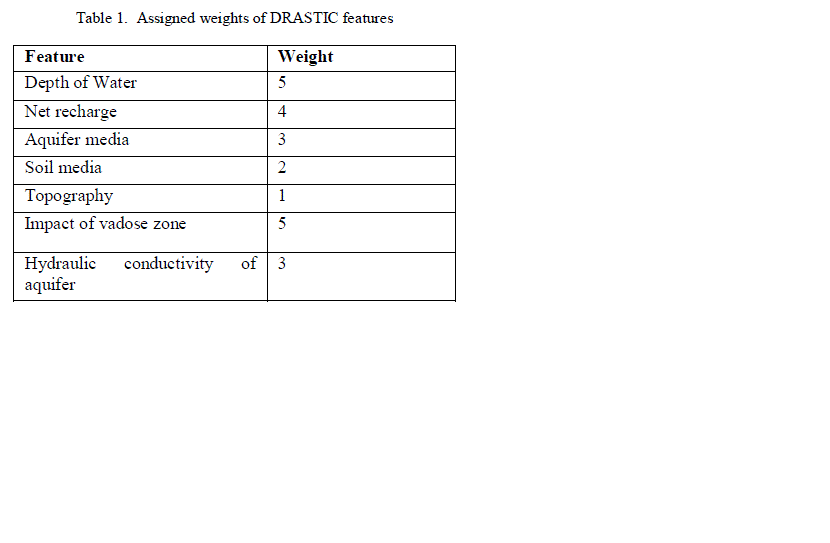
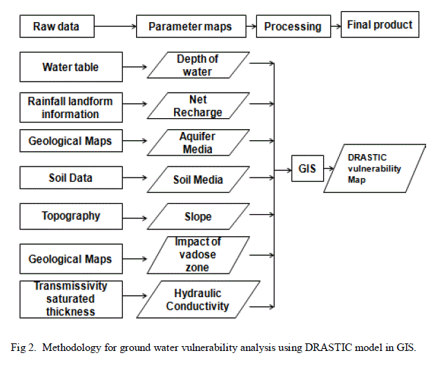
| DRASTIC is a methodology which allows the pollution potential of any area to be systematically evaluated. The physical characteristics are inherent in each hydrogeologic setting which affects the groundwater pollution potential. The most important factors that control the groundwater potential are D-Depth of water, R-Net recharge, AAquifer media, S-Soil media, T-Topography, I-Impact of Vadose zone and C-Hydraulic conductivity of the aquifer. These factors have been arranged to form the acronym, DRASTIC for ease of reference. In determining DRASTIC INDEX (DI) each factor has been assigned a relative weight ranging from 1 to 5, the most significant factors have weights of 5 and the least significant factor with a weight of 1 as shown in Table 1. Further, factor has been divided into either ranges or significant media types which have an impact on pollution potential. The range for each DRASTIC factor has been assigned a rating which varies between 1 (least pollution potential) and 10 (Highest pollution potential). The equation for determining the DRASTIC index (DI) is: |
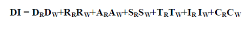 |
| Where D, R, A, S, T, I and C are the parameters, R is the rating of each parameter for the study area and W is importance weight parameter [3]. |
| D: Depth of Groundwater : |
| It is depth from ground to water table, deeper the water table lesser will be the chances of pollutants to interact with ground water. |
| R: Net Recharge: |
| It is the amount of water/unit area of land that penetrates the ground surface and reaches the water table, it is the reporting agents for pollutants to the groundwater. |
| A: Aquifer Media : |
| It is the potential area for water storage, the contaminant attenuation of aquifer depends on the amount and sorting of fine grains, lower the grain size higher the attenuation capacity of aquifer Media. |
| S: Soil Media : |
| Soil media is the uppermost and weathered part of the ground, soil cover characteristics influence the surface and downward movement of contaminants. |
| T: General Topography or Slope : |
| It refers to slope or steepness, areas with low slope tend to retain water for longer, this allows a greater infiltration of recharge of water and a greater potential for contaminant migration and vulnerable to ground water contamination and vice versa. |
| I: Vadose Zone: |
| It is the ground portion found between the aquifer and the soil cover in which pores or joints are unsaturated, its influence on aquifer pollution potential similar to that of soil cover, depending on its permeability, and on the attenuation characteristics of the media. |
| C: Hydraulic Conductivity of the Aquifer: |
| It refers to the ability of the aquifer formation to transmit water; an aquifer with high conductivity is vulnerable to substantial contamination as a plume of contamination can move easily through the aquifer. |
 |
| Software used: |
| 1. Arc GIS 10 |
| 2. ERDAS 9.1 |
| 3. Microsoft Excel. |
 |
RESULTS AND DISCUSSION |
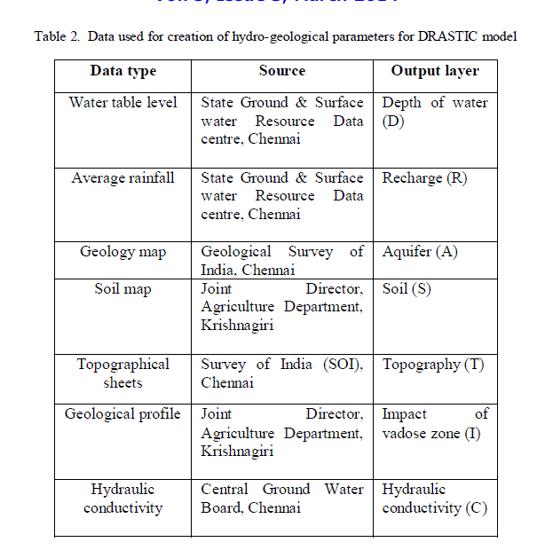
| A numerical ranking system to assess ground water pollution potential in hydro geologic settings has been devised using the DRASTIC factor. The system contains three significant parts: weights, ranges and ratings. The weight and ratings of different hydro geological parameters of Krishnagiri district has been calculated based on the pumping test data, rainfall and using various thematic maps. |
| A. Depth of groundwater (D) |
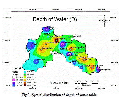
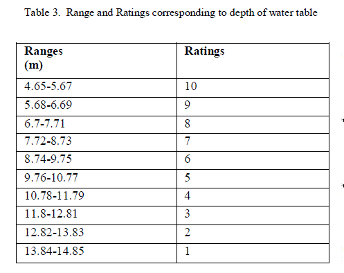
| The value of the variable D (Depth of water table) was obtained using pumping test data. The depth of water in the study area varies between 4.65 m to 14.85 m below the ground surface. In general, the deeper the water levels are, the longer the pollutant takes to reach the groundwater table [6]. The rating scores ranges between 1 and 10 on the basis of DRASTIC classification. The ratings assigned in the study area were presented in Table 3 and the spatial variation is shown in Fig.3 respectively. |
 |
 |
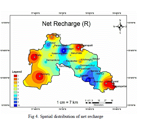
| B. Net Recharge (R) |
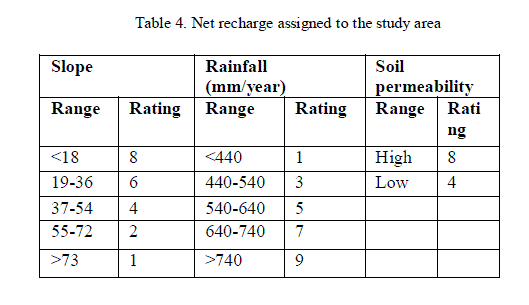
| Net recharge represents the amount of water that infiltrates into the ground and reaches the water table. The map incorporates available features like slope, soil permeability and rainfall, which are important for the calculation of recharge component [7]. A digital elevation model (DEM) of the study area was used to identify the slope % and soil permeability was calculated from soil type, average rainfall of the study area was used as a recharge index and the finalized recharge value was calculated and the ratings were assigned as presented in Table 4. |
 |
| The net recharge is the amount of water from precipitation and artificial sources available to migrate down to the GW. Recharge water is, therefore, a significant vehicle for percolating and transporting contaminants within the vadose zone to the saturated zone. It carries the solid and liquid contaminants to the water table and also increases the water table. Urban and built-up areas, open plots, and barren land were assigned a rating of 1 (Table 4) because it is the zone of highest runoff due to impervious surface areas. Water bodies and wetlands were assigned a rating of 8. An area with high Ground water recharge is at high risk because of the permeable pathway from the surface to the water table. So high recharge rates were assigned to these areas. Net recharge was then calculated using the following equation: |
| Net recharge = (Rainfall - Evaporation) × Recharge rate. |
| The recharge values observed in the study area ranges from 1 to 10. The ratings assigned to net recharge in the study area were presented in Table 5 and the spatial variation is shown in Fig. 4 respectively. |
 |
 |
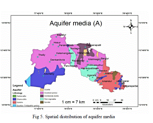
| C. Aquifer media: |
| Movement of groundwater in the aquifer medium is important in determining the time for attenuation processes, such as sorption, reactivity and dispersion to occur along with the amount of effective surface area of materials with which the contaminant may come in contact within the aquifer. The migration of contaminants is strongly influenced by fracturing, porosity, or by interconnected series of openings. Based on the geological description of the study area, the aquifer media was classified as Carbonatite, Syenite, Epidote, Granite, Pink migmatite, Granitoid-gneiss, Homblende-biotite, Quartzo Feldspathic gneiss, Charnockite, which has a rating of 1 to 9. The ratings assigned in the study area were presented in Table 6 and the spatial distribution of aquifer media is shown in Fig.5 respectively. The aquifer is defined as a rock formation which will yield sufficient quantities of water for use. The shallow aquifers occur within a depth of 50m from the earth’s surface. An aquifer media map was prepared from the well log data and topographical maps. In general, larger the grain-size and the more fractures or openings within the aquifers, the higher the permeability and lower the attenuation capacity; consequently the greater the pollution potential . So the coarse (saturated or unsaturated) media was assigned a high rating value compared to the fine media [3]. |
 |
 |
| D. Soil media: |
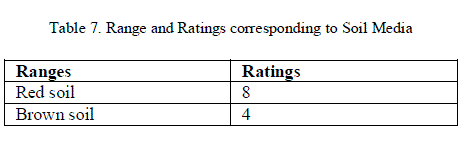
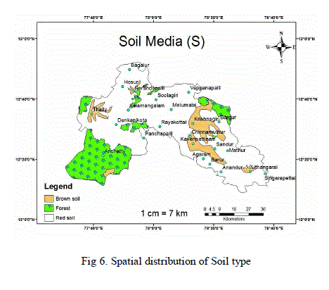
| Soil is commonly considered the upper weathered zone of the earth which average 1.8 m or less. Soil has a significant impact on the amount of recharge allowing infiltration to the water table and hence contaminant movement. The study area is characterized by Red soil and Brown soil, which corresponds to ratings of 8 and 4 respectively as presented in Table 7 and the spatial variation of soil media in the study area is shown in Fig.6 respectively. |
 |
| E. Topography: |
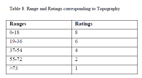
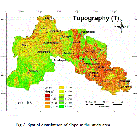
| Topography is considered as the slope and slope variability of the land surface. Topography helps to control pollutants runoff or retention on the surface. Slopes that provide a greater opportunity for contaminants to infiltrate will be associated with higher groundwater pollution potential. The slope index, which was derived from the DEM to find the ratings for recharge, was reclassified on the basis of DRASTIC classification. The ratings assigned in the study area and spatial distributions of slope were presented in Table 8 and Fig. 7 respectively. |
 |
 |
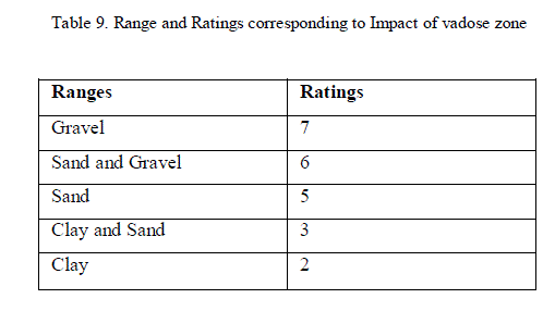
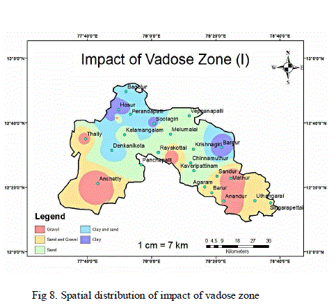
| F. Impact of Vadose Zone : |
| The vadose zone refers to the zone above the water table, which is unsaturated and its type determines the attenuation characteristics of the material including the typical soil horizon and rock above the water table gravel, gravel-sand, clay-sand and clay are considered the vadose zone of the study area. According to the DRASTIC ratings the value for impact of vadose zone is shown in Table 9 and spatial variations were presented in Fig.8 respectively. |
 |
 |
| G. Hydraulic Conductivity : |
| Hydraulic conductivity is defined as the ability of aquifer materials to transmit water and it is controlled by the amount and interconnection of void spaces within the aquifer that may occur as a consequence of inter-granular porosity, fracturing and/or bedding planes. For the purposes of the present study, hydraulic conductivity has been calculated from the pumping test data and spatial hydraulic conductivity map obtained from geological survey of India. The hydraulic conductivity ranges between 1.17 m2/day to 186.77 m2/day in the study area. The ratings based on hydraulic conductivity are shown in table 10. The spatial distribution is shown in Fig.9 respectively. |
 |
| DRASTIC Index: |
| The DRASTIC index, a measure of the pollution potential, is computed by summation of the products of rating and weights of all seven parameters as discussed above. From the computed DRASTIC index it is possible to identify areas which are more likely to be pollution potential. The vulnerability index ranges from 74 to 151 and is classified into three groups i.e. 74-90, 90 to 135 and 135 to 151 corresponding to low, medium and high vulnerability zones respectively. Using this classification a groundwater vulnerability potential map (Fig.10) was generated which shows that 17.39% area falls in low vulnerability zone and 60.87% falls in medium vulnerability zone. About 21.74% of the study area falls in high vulnerability zones. The vulnerability map thus generated helps in identifying areas which are more likely to be susceptible to groundwater contamination relative to one another. |
 |
CONCLUSION |
| An attempt has been made to assess the aquifer vulnerability of Krishnagiri district employing the empirical index DRASTIC model of the U.S. Environmental Protection Agency (EPA). Seven environmental parameters were used to represent the natural hydrogeological settings of the aquifer, Depth of groundwater, Net recharge, Aquifer media, Soil media, Topography, Impact of vadose zone and Hydraulic conductivity. The results shows that vulnerability index ranges from 74 to 151 and is classified into three classes i.e., 74-90, 90 to 135 and 135 to 151 corresponding to low, medium and high vulnerability zones respectively. The vulnerability map thus generated helps in identifying areas which are more likely to be susceptible to groundwater contamination relative to one another. |
References |
|