International Journal of Innovative Research in Science, Engineering and Technology
ISSN ONLINE(2319-8753)PRINT(2347-6710)
ISSN ONLINE(2319-8753)PRINT(2347-6710)
| Jagdish B. Sapkale Assistant Professor, Department of Geography, Shivaji University, Kolhapur, Maharashtra, India. |
| Related article at Pubmed, Scholar Google |
Visit for more related articles at International Journal of Innovative Research in Science, Engineering and Technology
Sea waves are the powerful agent of seashore erosion. Once waves attacked on coasts; beaches and headlands are the landforms which faces first and finally influenced by wave energy in terms of erosion. In the coastal areas; beaches, sand bars, sand spits and sand dunes are the depositional landforms which continuously interact with tidal waves. Among these, sand dunes are the coastal feature which also significantly protects the landward ecosystem and settlements by the disastrous effects of tidal waves, storms, cyclone, tsunamis etc. The present research work attempted to study the sand dunes of Mithmumbari and Kunkeshwar- the coastal areas of Devgad, Maharashtra. The study also focussed on degradation of sand dunes in the study area.
Keywords |
| Sand dune, Degradation, Sand mining, Human intervention,SRTM data, Casuarina Plantation. |
INTRODUCTION |
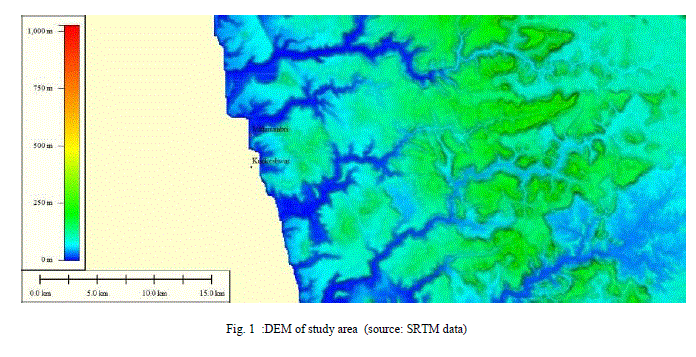
| The coast is a zone with innumerable erosional and depositional features like beaches, sand bars, sand spits, sand dunes, cliffs, rocky platforms that contemporary a part between land and sea. Sea waves are the dominant agent of erosion and deposition in coastal areas. Wave energy and shoreline currentsare responsible to develop erosional and depositional features in the coastal zones. Coastal sand dunes are the depositional landforms formed by wind action on the landward side of the beaches. Generally sand dunes are halted by vegetation that traps the sand [1].Sand dunes also support plant and animal species. Coastal sand dunes indicatevariability in its form in terms of its sediment property, climatic factor and ecological factors. The basic requirement for the formation of sand dunes is abundant sediment in terms of sand supply and the wind to transport it [2].According to Abramowitz,“Dunes, barrier islands, mangrove forests, and coastal wetlands are natural shock absorbers that protect against coastal storms. Nature provides these valuable services for free, and we should take advantage of them rather than undermining them” [3]. The quoted words of Abramowitz are very much sensitive; Most of the regions along the coasts are under the pressure of increasing population. Unplanned use of available resources leads many serious problems. Degradation of coastal wetlands, mangrove forests, beaches, sand spits, sand dunes have also observed in the coastal areas of Maharashtra.These dunes are protecting the coastal settlements and their agricultural lands from the storm and sea surges. According to the Gomez-Pina et.al [4], the dune systems are the most capable and least expensive defence against shoreline erosion. However, the loss of vegetation that traps and holds sand makes the dunes and beach more vulnerable to wind and water erosion. According to Healy and de Lange [5], degradation of sand dune occurs due to erosion and effectively influenced by wind velocities. Sand moves in another place through long-shore drift, or littoral drift. Human activities also effects on sand dunes with tourism activities, road constructions, cropping-agricultural activities and grazing of animals[4].Now a days increasing pressure of population in coastal areas; increasing demands of housing, recreations, and excavation activities are also resulting for degradation of sand dunes. Land reclamation for road construction and hotel/resort construction are also the major threats to sand dune degradation.Therefore, it has attempted to study the coastal sand dunes in the coastal tracts of Mithmumbari and Kunkeshwar of Devgad, Maharashtra (fig 1). |
MATERIALS AND METHODS |
| The present research work is related to study the coastal sand dunes and their destruction in the study area. Besides this, the study requires the contouring of some sand dune sites and to generate some profiles. Therefore, the information and primary data have been collected through conducting field work. Intensive field work and field surveying was the base for research work. Surveying was carried out using Transit Theodolite, electronic Theodolite and GPS. On the basis of surveying data contour map and profiles were prepared for the present study. Prior to conduct field work and Surveying, the topographical maps and images from Google earth have been used for identification of sand dunes in coastal area. Change detection in terms of sand dune disturbance for past years have analysed by using Remote Sensing data and Google earth images. Profiles of Mithmumbari and Kunkeshwar duneswere also prepared by using SRTM data and global mapper software. |
 |
RESULTS AND DISCUSSIONS |
| Dunes are the mounds of drifted sand on the beach. The formation of the dunes and beaches varies constantly because of their dynamic nature. Most beaches of study area are supported by uneven heights of sand dunes ( fig.2-a). The main requirements for the formation of sand dunes are sand in terms of deposition on the beaches, wind and vegetation. Therefore the dune vegetation i.e. Kevada (fig. 2-b) and casuarina (fig. 2-c) plays an important role for reducing the wind speed and also reduces the movement of sand from the dune. The area of developing dune at initial stage is nearest towards the sea and frequently free from vegetation towards the sea. It is immediately above the high tide level with its steeper face inland. The plants growing on these dunes are Ipomoea and small grasses. These dunes are backed by mid shore dunes with shrubs and uneven vegetation species. At the backshore zone the sand dunes are more stable with Casuarinas and Kevada plantation. Such vegetation holds the sand dunes and supporting for its growth in the areas where there is an abundant supply of sand. Figure 2-c shows the dense vegetation of casuarina at Mithmumbri, from this site newly constructed road dissected the sand dunes for tourism activities, which will be the future threat to this vegetation and sand dunes. The erosionand deposition of the dunes are taking place simultaneously, depends on the type of material and its size and also depends on the climatic conditions. Figure 2-d shows the embryo dune, fore dune and back dune. Diverse particle size of the sand and the processes of dune formation are responsible for showing uneven distribution of dunes here. According to Blott and Pye [6] in 2001,Grain size is the most important property of sediment particles, affecting their entrainment, transport and deposition. The sediment transported beyond the berm line of the beach is composed predominately of fine to medium grained,well-sorted sand; this is due to the aerodynamics of grains of this particular size, i.e. entrainment of sand-size |
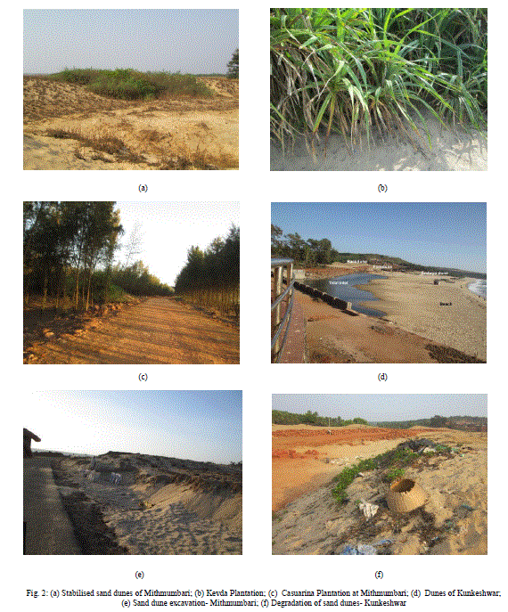 |
| grain requiresa lower shear stress [7]. Shell fragments are often preferentially moved by wind, as they are less dense than the quartz sand grains; where it is abundant this can lead to an accumulation of shell material. Morphological development of embryo dunes (fig.2-d) depends on wind velocity, rates of sand transport and plant density, distribution, height and cover. Tall, dense species such as Ammophila arenaria tend to produce higher hummocky dunes whereas lower, spreading plants such as Ipomoea tend to produce lower less hummocky dunes [8]. Foredunes develop from embryo dunes and are commonly distinguished by the growth of intermediate, often woody plant species, and by their greater morphological complexity, height, width, age and geographical position. Typically they attain heights up to 5m [9]. Hesplists the factors determining the morphological evolution of fore dunes to include: sand supply; the degree of vegetation cover; the rate of aeolian sand accretion and erosion; and extent of human impact [8]. Dunes are out of the influence of regular waves, they are susceptible to only uncertain storm surges and cyclones. In these conditions embryo dunes can be destroyed and sand easily removed from the seaward edge. Dunes may also be eroded internally by the formation of blowouts. Blowouts are large depressions that develop as sand is eroded from the windward slope [8, 10]. In view of this, it is necessary to minimise the natural and man-made erosion of dunes.In the coastal tracts of Maharashtra mudflat, salt marshes, coastal rice farms, kharland etc. are protected by sand spits, sand dunes and sand bars [11, 12]. |
| PROFILES |
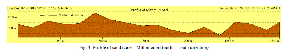
| Figure no. 3 and 4 are the Profiles of Mithmumbri and Kunkeshwar’s sand dunes from North to South direction along the coastline [13]. Mithmumbri’s profile – (North- south directions-dissection along the sand dune) shows 5-6 depressions and 6-7 mounds with an average height of 7-8 metres. This profile is drawn in the western side of this site;Length of this sand dune extends up to 1500-1550 metres. Northern part of dune is more elevated and well stabilised due to casuarina plantation. Somewhere, the height ranges up to 12-13 metres. In the southern portion some depressions occurs due to sand mining and excavation activities (fig 2-e). |
 |
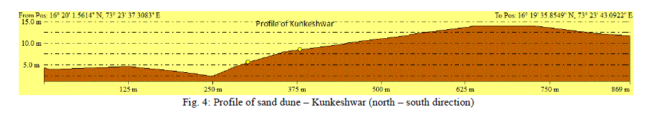
| Consequently, Length of the Kunkeshwar’s sand dune extends up to 850-900 metres. Towards its North western side the height of the sand dunes ranges from 2-4 metres andshows the increase in height towards its south eastern side for 12 metres. Figure 4 shows the erosion of the sand dune by a small tidal inlet of Kunkeshwar. At this site a road with bridge over the tidal inlet has constructed and passes through the well-developed stabilised sand dune, the activity resulting for the degradation of the sand dunes.The southern side dune represents old and stable dune. Behind the back dune of this site, the new construction of resorts is going on, may be disturb the dune. Most of the dune is without grass cover, degradation due to human activities is increasing at this site (fig 2-f). |
 |
| For change detection, google images of two different periods i.e. 31/12/2003 and 15/01/2014 have been used (fig 5-(a) to (d). Mostly Sand dune of Mithmumbari was exposed during 2003 (fig 5-a) and was more prone to wind erosion. Nearly after 10 years, some northern side, half portion of this dune site is covered by casuarina plantation during 2014 (shown with encircled red coloured oval in fig 5-b). There is a need to conserve this sand dune site with such type of plantation and vegetation cover, but southern side of this dune is nearly exposed and under the threat of degradation. In the same figure(5-b) newly constructed road is seen here, that has indicated by encircled yellow oval. This newly constructed road is joined to Kunkeshwar to its south. The road is parallel to the sea and very close to the berm line of the beach, small bridge has also constructed at the southern tip of this site. This gives initial signs of dune degradation. In near future, this stable dune of Mithmumbari will rapidly decline due to tourism activities. Same situation occurs at the Kunkeshwar site also. Kunkeshwar is a pilgrimage tourist place, number of tourists and pilgrim visitors are visited in all seasons to this site. It has seen that, recreational facilities and constructions of road and hotels lead to sand dune degradation. Small bridge has constructed over tidal inlet during 2013-2014 and road has extended towards southern side of this site connected to the location of resorts. This new road has passes through the sand dune, shown by encircled yellow oval in figure 5-d. At some locations, mining of sand from the stabilised dunes have also observed at these sites. At these sites, there is a need to protect the sand dunes by applying some conservative methods. Initially at the degraded sites, wooden fencing can be use. Such wooden fencing may trap the sand coming towards the landward side and supports for sand deposition. At some extent this could be work as a protective obstacle and reduces the natural erosion.There is an urgent need to grow casuarina type plantation at this site also. Continuous monitoring is required for these and similar sites of sand dunes in the study area, as this natural landform protects the landward side settlement. |
CONCLUSION AND SUGGESTIONS |
| On the basis of the study it has concluded that, Sand dunes are more prone to degradation in future. It has identified that coastline of the study area is specifically marked with a variety of geomorphological features with differentiate coastal landforms. Coastal landforms are produced due to stability of erosional and depositional processes which are influenced by the sea waves and tidal energy. Primarily the sand dunes, bars, spits and beaches are associated with the depositional landforms of the coastline. Coastal erosion and deposition are composite processes that must be examined from the viewpoint of sand and silt movement due to wave. Construction of houses, hotels and industrial plants should be strictly banned near the beaches and coastal landforms. There should be complete ban on the roads and paths of the vehicles that passes across the dunes. Destruction of dunes by human activities has been seen in the study area. Violation of coastal regulation zone must be identified and strict ban should be implemented for sand quarrying and sand excavationin the coastal area. |
ACKNOWLEDGEMENT |
| The Author would like to express his sincere thanks to Shivaji University, Kolhapur for providing the financial assistance to conduct field work for this research work under the scheme of UGC- SAP. The author is also thankful to the M.A. /M.Sc. Students- Ashwini Mane, Rohini Mane, Rohit Mane, Satish Maske and Rohit Mohite for their help during the field Surveys. |
References |
|