ISSN ONLINE(2319-8753)PRINT(2347-6710)
ISSN ONLINE(2319-8753)PRINT(2347-6710)
Poornima.K.V1 and Sravan Chinthaparthi2
|
| Related article at Pubmed, Scholar Google |
Visit for more related articles at International Journal of Innovative Research in Science, Engineering and Technology
Coastal change detection is critical in coastal zone application. Occurrence of tsunami on December 2004 had a drastic impact on the Tamil Nadu coast leading to changes in coastal features. Therefore accurate detection and proper monitoring of the coast is very essential to understand the coastal process and dynamics of various coastal features which will be helpful in accessing the dynamic nature of coast .This study deals with the coastal change detection of the Chennai coast few years before and after occurrence of the Tsunami using satellite imagery for effective environmental monitoring and assessment. The use of satellite imagery is advantageous over aerial photography and field survey which was previously in use as the satellite imagery provides wide coverage and multi spectral information and is cost effective which is not possible with aerial photography and field survey. In this study, LANDSAT data between 2000 and 2012 were used and change detection was performed through image processing techniques and classification algorithms. Future predictions were made using CA_Markov analysis. Results of this study showed a significant effect of Tsunami in coastal changes.
Keywords |
| Coastal change, Chennai coast, LANDSAT data, Change detection, Prediction, CA_ Markov. |
INTRODUCTION |
| Coastal zone is very dynamic and its monitoring is an important task in sustainable development and environmental protection. It is the place where the land and water meet. Development of infrastructure along the coastal area and also climate, tectonic change and other natural calamities have given rise to problems like erosion and accretion, salt water intrusion , degradation of natural resources. This study analysis the coastal changes along the coast of Chennai, which is a small portion of Tamil Nadu. Long term shoreline assessment has been carried out by making use of aerial photographs (George L. Smith, Gary A. Zarillo,1990).[1] and using satellite images(A.A.Alisheikh, A.Ghorbanali,N,Nouri,2007). [2] and by many other researchers. The synoptic viewing capability , the multispectral observations and the cost effectiveness of the remotely sensed data has made it a sought after option for analysing the coastal changes and to know the evolution of coastal and near shore areas. Coastal studies have been carried out by many researchers such as Richa Choudhary, R. Gowthaman and V. Sanil Kumar(2013).[3]; Manik Mahapatra, Ratheesh.R and Rajawat A.S(2013).[4]. |
II. RELATED WORK |
| There are various methods available for coastal change detection. (S.Kaliraj et al.,2013).[5] made use of the Landsat TM and ETM+ images which was classified into two classes to extract the coastline and ArcGIS software was used to detect the changes , rate of erosion and accretion were analysed. (Valerio baiocchi et al.,2010).[6] used water automatic detection technique and single band analysis to demarcate the boundary between land and water. Band ratio techniques were implemented in analysing the coastal change as carried out by (Philipi Neri Jason Quashigah et al., 2013).[7].Histogram equalization method was performed on Landsat ETM and LISS III images to distinguish between the different land cover features and mapping of these landcover features were done through the ArcGIS 9.1 software and change detection was performed by (Krishnakumar.P et al., 2011).[8].Landsat TM data was used for the study and Markov cellular automata technique was implemented to predict the future land use by (Shahidul Islam et al.,2011).[9].(Kumaravel.S et al., 2013).[10] had used the IRS data and edge detection techniques to demarcate the shoreline and digitisation was done using the Arc GIS software to determine the changes. |
III. STUDY AREA |
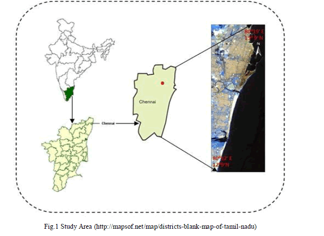
| Chennai is situated to the south eastern coast of India on a flat coastal plain. The district is surrounded by other district in the state like the Kancheepuram and Thiruvallur districts, while the Bay of Bengal lies to the east of the city. The coast stretches around 25.60 kms. The city district lies between 1209' and 1309' N and 800 12' and 800 19' E. |
 |
Data source |
| LANDSAT data have been used in this study which has been acquired from United States Geological Survey(USGS) Data from the years 2000 to 2012 maintaining a gap of 2 years were acquired. Also the digital elevation models of the study area was acquired from USGS. |
Methodology |
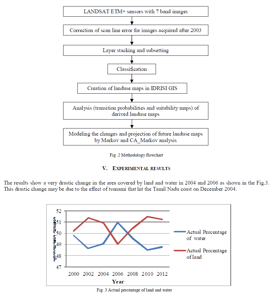
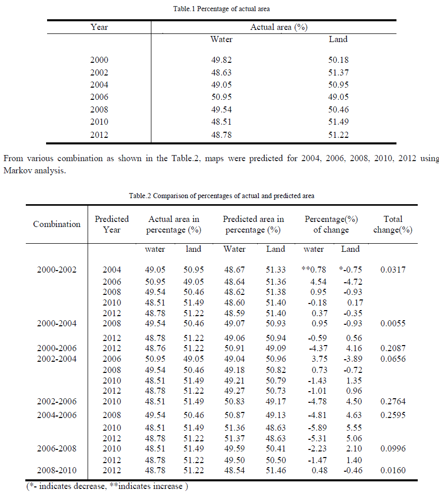
| In this present study, multi temporal LANDSAT ETM+ images acquired from 2000 to 2012 were used as the primary data source. The missing scan lines present in the images from 2003 onwards were corrected using interpolation technique through MATLAB . S. Kaliraj & N. Chandrasekar and N. S. Mageshhave (2013).[11]; Pal NR and Pal SK (1993).[12]; White and El Asmar (1999).[13]; Lillisand and Kiefer (2000).[14]; Hegde AV (2010).[15]; Dewidar KM and Frihy OE (2010).[16]; Charatkar et al., (2004).[17] used LANDSAT images acquired at different times to analyse the coastal changes based on spectral signatures of land and water. Based on this principle the images were classified into two classes namely land and water using maximum likelihood classification based on the accuracy assessment tests performed on each image as carried out by Usha and Subramanian (1993).[18]; Braud and Feng (1998).[19]; Liu and Jezek (2004).[20]; Guariglia et al. (2006).[21]; Kaliraj and Chandrasekar (2012).[22]. These classified images were imported into IDRISI GIS through which the changes in the coastal area (land and water) for various years from 2000 to 2012 with an interval of two years were found out and compared as given in Table.1 .Using various combinations of maps from 2000 to 2012,transition probability matrices were generated as carried out by Takada T, Miyamoto A and Hasegawa SF (2010).[23]; Sravan Kumar CV (2013).[24]; and predictions were made using Markov and CA_Markov analysis as shown in Table.2 and based on the combination with least change, the future maps were predicted for the year 2016 and 2020. |
 |
 |
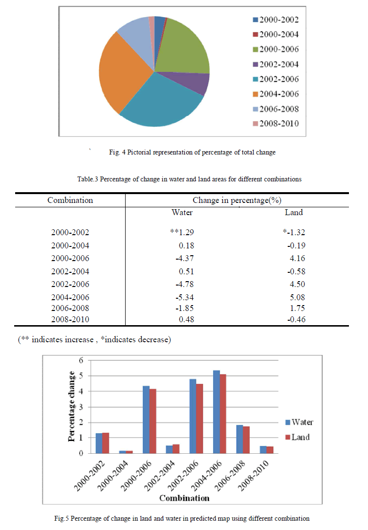 |
| In order to find the combination with least change, two analysis were performed as shown in Table.2 and Table.3. The first analysis as shown in Table.2 was calculated by taking the average of percentages changes in all predicted maps in each particular combination.The second analysis as shown in Table.3 is performed by determining the percentage changes in water and land area for various combinations. From the two analysis, the combination 2000-2004 was found to have least change when compared to other combinations. This combination was therefore used to predict the future coastal map. Thus maps of 2016 an 2020 were predicted using the combination of 2000-2004.The Fig.4 and Fig.5 shows the graphical representations of the results of the first and second analysis as represented in Table.2 and Table.3 |
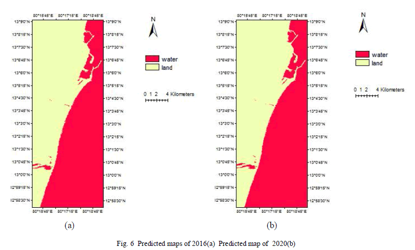 |
| The predicted map of 2016 and 2020 as represented in Fig.6 indicates that the percentage of area covered by water and land were 49.088 % , 49.078% and 50.912% , 51.387% respectively. The percentage of change expected by comparing 2016 map to 2020 map showed a 0.022% increase in water, and 0.021% decrease in land. |
VI. DISCUSSION AND CONCLUSION |
| Based on the above study it has been noted that, the Markov and Cellular Automata analysis are more or less providing accurate predictions based on the immediate changes but there are few draw backs such as it is a must that all the study years should have exactly same areas, otherwise Markov analysis cannot be applied and also land use classes must be same to perform the CA_Markov analysis as we assumed uniform gap between the study years and the predicted years, this methodology seems to be giving good predictions almost equal to the original areas. But if the uniform gap is not maintained then predictions may not be accurate. So there is a need to check for any other methodology which can account for the same. Here a gap of 2 years between the study areas have been taken and analysis has been carried out. A comparision between 2 year and 1 year or monthly differences of the study area can be attempted. Thus the analysis of coastal changes along the study area using multitemporal LANDSAT images reveal that the rates of change in the coastal zones are fluctuating. Moreover, it is observed that the maximum change in the area during 2004–2006 as shown in Fig.3 is due to the impacts of the 2004 tsunami and also the comparison between the 2016 and 2020 map showed a increase in area covered by water and decrease in area covered by land thus indicating erosion of the coast to an extent in the near future. The results of the predicted maps of 2016 and 2020 were found to be in accordance with the results obtained from the combination of 2000-2004. |
VII. ACKNOWLEDGEMENT |
| The authors would like to thank Hakim Abdi from Geoinformatic Organization for providing his support via emails. Also I Poornima.K.V, one of the authors would like to thank my co-author Mr.Sravan Chinthaparthi who has been my guide too throughout this endeavour to make this a successful one. |
References |
|