International Journal of Innovative Research in Science, Engineering and Technology
ISSN ONLINE(2319-8753)PRINT(2347-6710)
ISSN ONLINE(2319-8753)PRINT(2347-6710)
S. A. Kadam1, S. D. Gorantiwar2, S. N. Das3 and A. K. Joshi4
|
| Related article at Pubmed, Scholar Google |
Visit for more related articles at International Journal of Innovative Research in Science, Engineering and Technology
As evapotranspiration is one of the main components of hydrologic cycle, its estimation is very important. Remote sensing technologies can assist to improve the estimation accuracy also providing means for computing evapotranspiration geographical distribution. In the present study, the daily actual evapotranspiration was calculated for wheat crop in Rabi season during the crop growth cycle uniformly. FAO Penman-Monteith method adapted to satellite data was used for the estimation of actual crop evapotranspiration for wheat crop using satellite data together with ground meteorological measurements. Satellite data, following the necessary processing, were used in conjunction with surface data from the nearest meteorological station. The IRS LISS-III satellite images were used to calculate, albedo NDVI and LAI required for the estimation of actual crop evapotranspiration (ETc) for wheat crop. The actual crop evapotranspiration for wheat crop varied from 0.95 to 3.43 mm/day during the crop growth period. The ETc values estimated from satellite data by direct application of FAO Penman Monteith method are on an average 16.54% lower than ETc values estimated as multiplication of Kc from lysimeter data and ETr from meteorological data. It is obvious that ETc sourcing from IRS LISS-III and meteorological data is always less than that of the FAO. The reason for this could be the low resolution of IRS LISS-III pixel. The difference is insignificant, when both the values were compared with t-test for paired two sample means.
Keywords |
| Remote sensing, crop evapotranspiration, wheat, FAO Penman-Monteith method |
INTRODUCTION |
| For a sustainable water resources management, the accurate estimation of actual evapotranspiration is necessary, mostly in the agriculture, especially now a days that there is increasing demand and decreasing availability of the water resources for agriculture. However, it is very difficult to estimate actual crop evapotranspiration as it depends on various parameters which vary in time and space. Several empirical conventional methods have been developed over the last 50 years by numerous scientists to estimate evapotranspiration from different climatic variables. The analysis of the performance of the various calculation methods revealed the need of a standard method for the calculation of the reference crop evapotranspiration. The FAO (Food and Agriculture Organization of the United Nations) Penman- Monteith method has recently been recommended as the standard method. Recently, the estimation of actual evapotranspiration at regional scale has been widely studied using combining meteorological data with remotely-sensed data. Estimation of evapotranspiration combining conventional meteorological ground measurements with remotelysensed data have been also widely investigated [1]. Low resolution NOAA images were used for ETc estimation [4], medium resolution Landsat/ETM+ satellite images were used for ETc estimation [7, 8, 10] and ASTER satellite images for estimation of ETc were used by [3]. The methods of estimating ETc is generally classified as: (a) energy balance methods, (b) aerodynamic or mass transfer methods, (c) empirical or semi-empirical methods, (d) water depletion methods and (e) numerical or modeling methods [6]. The analysis of the performance of these models revealed the need for formulating a standard method for the computation of ETc [5]. The FAO-56 method, which was derived from the Penman-Monteith equation, has recently been recommended as the sole standard method [11]; this a method predicts ETc in a wide range of locations and climates [2]. By using remotely-sensed data the estimation of regional evapotranspiration is technically and economically feasible, since the remotely-sensed data provide estimations of high spatial and temporal resolution. Therefore, in this study the FAO Penman-Monteith method adapted to satellite data was used for the estimation of ETc for wheat crop. |
DATA AND METHODOLOGY |
| A. Resources |
| In order to estimate evapotranspiration using FAO Penman- Monteith method adapted to satellite data, the meteorological data from Indian Meteorological Department (IMD) station located at 19024’0’’N to 74039’00’’E at Water Management Project at Mahatma Phule Krishi Vidyapeeth, Rahuri was used. The data include air temperature, relative humidity, atmospheric pressure, wind speed, and sunshine hours. Nine, IRS LISS-III were used, dating from November, 2012 and harvested in March, 2013. These data were used to retrieve the surface albedo, NDVI, LAI and Kc from surface reflectance bands of IRS LISS-III data. |
| B. Study area |
| The data required for this study were collected from Wheat field at D-Block of Mahatma Phule Krishi Vidyapeeth, located at 19019’58.779’’N and 74040’23.348’’E during 2012-2013. The field was the seed plot. The seed plot was selected for the study because all the standard cultivation practices are adopted during the crop growth cycle and the crop is maintained in unstressed condition. The wheat field was border-irrigated. The crop was sown in November, 2012 and harvested in March, 2013 and the data were recorded during this period. |
| C. Methodology |
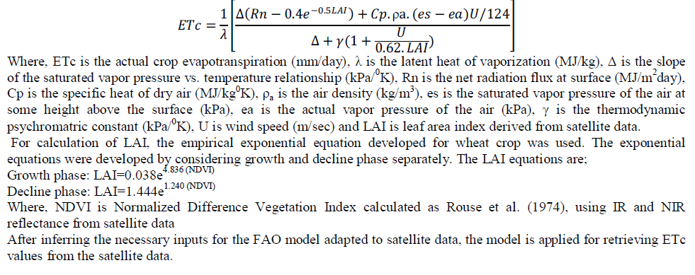
| FAO method adapted to satellite data was used to estimate ETc. The use of both satellite and meteorological data are required to use the method. The specific equation which is used to estimate ETc, under certain conditions is based on the direct application of the Penman-Monteith equation with canopy parameters estimated from satellite imagery. Air temperature, atmospheric pressure, wind speed and other data were collected from meteorological stations located near the study area. The following equation is used for estimation of ETc based on satellite data and meteorological data. |
 |
RESULTS AND DISCUSSIONS |
| A. ETc of wheat crop |
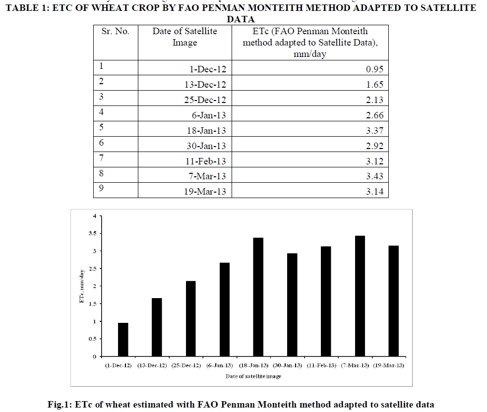
| The crop evapotranspiration was obtained by applying FAO Penman Monteith adapted to satellite data and traditional for wheat crop derived from the reflectance data. Table 1 shows ETc values for wheat crop for all the dates of satellite images during the crop growth period. The wheat plot used in this study is greater than 120 x120 meters (5 x 5 IRS LISS-III pixels) so as to have the opportunity to exclude the pixels which are the edge of plot. This procedure allows for avoiding mixed pixels (non-vegetated-vegetated) that could provide the misleading results regarding ETc. 4 x 4 IRS LISS-III pure pixels were selected for the estimation of ETc for wheat crop. It is observed from Table 1, that the ETc estimated with Penman Monteith adapted for satellite data varied from 0.95 to 3.43 mm/day. Figure 1, graphically represents the results of the direct application FAO Penman Monteith method. Y- axis represents the ETc in mm/day and X-axis the dates or days after sowing of wheat crop for which there are satellite images. |
 |
| B. ETc comparison |
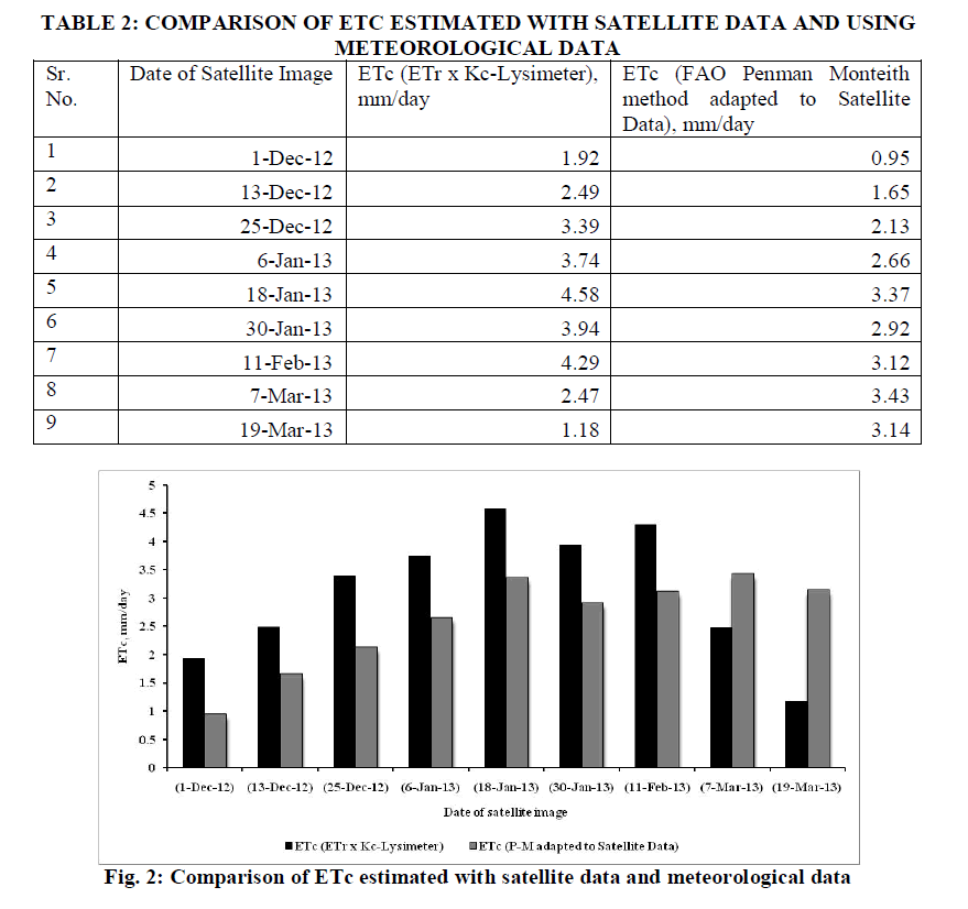
| FAO Penman-Monteith method for estimating crop evapotranspiration (ETc) has been applied using IRS LISS-III satellite data and meteorological records. The final results have been tabulated and shown in Fig. 1. These results were compared to the FAO-56 method using only meteorological data and using a single crop coefficient for wheat (Kc) calculated using lysimeter data. It is observed from Table 2 that, the ETc values estimated from satellite data by direct application of FAO Penman Monteith method are on an average 16.54% lower than ETc values estimated as multiplication of Kc from lysimeter data and ETr from meteorological data. It is obvious that ETc sourcing from IRS LISS-III and meteorological data is always less than that of the FAO. The reason for this could be the low resolution of IRS LISS-III pixel. The difference is insignificant, when both the values were compared with t-test for paired two sample means. |
 |
CONCLUSIONS |
| FAO Penman-Monteith method adapted to satellite data was used for the estimation of actual crop evapotranspiration for wheat crop using satellite data together with ground meteorological measurements. The actual crop evapotranspiration for wheat crop varied from 0.95 to 3.43 mm/day during the crop growth period. The ETc values estimated from satellite data by direct application of FAO Penman Monteith method are on an average 16.54% lower than ETc values estimated as multiplication of Kc from lysimeter data and ETr from meteorological data. The difference is insignificant, when both the values were compared with t-test for paired two sample means. |
References |
|