International Journal of Innovative Research in Science, Engineering and Technology
ISSN ONLINE(2319-8753)PRINT(2347-6710)
ISSN ONLINE(2319-8753)PRINT(2347-6710)
Eric Alain TCHIBOZO*1 Etienne DOMINGO2 Enagnon Brice SOHOU3
|
| Corresponding Author: Eric Alain TCHIBOZO, |
| Related article at Pubmed, Scholar Google |
Visit for more related articles at International Journal of Innovative Research in Science, Engineering and Technology
This article aims to assess the fragmentation level of Ouémé - Boukouclassified forest and analyze the vulnerability of itsvegetationplants. The methods used are made up of a multidisciplinary approach, based on the photo - interpretation by visual enhancement and image assisted classification, lineaments photo - interpretation, spatial analysis and digital mapping. The results obtained show that Ouémé - Boukou classified forest is covered by a 46.35% of the wet vegetation (20.75% water), unevenly distributed and under the pressure of natural factors (27.08% for flooding, 21.43% for the differential soil erosion, 17.89% for the weathering of rocks, 17.24% for the network of fractures and lineaments) and anthropogenic factors (16.36% for mosaic crops and fallow). The vulnerability of vegetation plant is varied and depends on factors considered. For all factors, the grassland is the most affected (37.31% for the flood, 33.43% differential soil erosion, 39.69% for the weathering of rocks, 35.00% for the network of fractures and lineaments and 34.64% for the mosaic of cultures and fallow). A portion of all vegetation (44.45% or 1,012.94 hectares) is fragmented islands with less than 25 hectares. Savanna and gallery forest are the most fragmented below this threshold habitats. This situation indicate that the forest structure and biodiversity are fast, deep and lasting affected.
Keywords |
| fragmentation, Oueme-Boukouclassified forest, vulnerability, vegetation plants. |
INTRODUCTION |
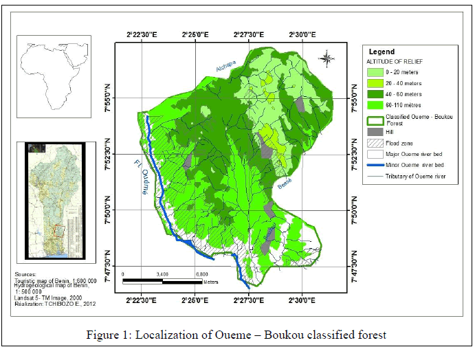
| The world's forests are increasingly vulnerable to human activities (FAO, 2011). Natural or artificial forest fragmentation has become one of the greatest threats to forest biodiversity in Europe (EEA, 2011). Fragmentation changes the tropical forests dynamics and alters the reproductive cycles of species (Aguilar et al., 2006, Lindenmayer et al., 2006). It can help to change the microclimate in forest fragments (Heithecker et al., 2007, Laurance et al., 2008). In Benin, the vegetation plants fragmentation is little studied.The forestry sector is currently facing many problems including poor management of wildlife resources and their habitat. The degradation rate of plant cover is estimated at 70 000 ha / year (FAO, 2007). National Remote Sensing Center of Benin (CENATEL) reports that from 1978 to 1998, the main courses fell by 3 million hectare, whether 160,000 hectare per year. Studies suggest a reduction of almost half the forest cover by half a century if nothing is done (National Strategy and Action Plan for the Conservation of Biodiversity in Benin, 1998).According Sinsin and Kampmann (2010), Benin forests are fragmented by the adverse of human activities such as bush fires, uneven logging and slash with burn shifting cultivation. The most visible position at the east - Center of Benin is characterized by deforestation of several forest reserves. Indeed, in this part of the country (which begins beyond 7° north latitude), large areas of natural forests is available (Report of the National Program for Sustainable Management of Natural Resources, 2008). It is a transition zone not only geographically, but also demographically and vegetation cover. There are several forest reserves and state protected areas of that are under anthropogenic pressure and used for the supply of timber, and energy service (Economic and Social Council of Benin, 2011). The forests are the main supply of fuel wood pool surrounding cities and therefore a source of income for the population.That of Oueme - Boukou, despite its status as classified forest, currently has a degradation fragmentation must be assessed in order to save (FAO / EC, 2000). The Oueme – Boukou classified forest, target of this study, is located in center of Benin, in the Municipality of Save (The hills department), between the geographic coordinates 7° 47' 00 '' and 7° 57' 00'' north latitude, 2° 22’ 00’’ and 2° 31' 30'' east longitude. A total area covers is 20,763 hectare and is bounded to the north by Atchakpa river, about 7.20 kilometers of Gobi (riverside village of Inter - State National’s road of Cotonou - Parakou (Benin ) - Gaya (Niger ), the South by Boukou river to the east by Besse river and west by Oueme river (figure 1). |
 |
| The objective is to assess the fragmentation level of Oueme - Boukouclassified forest and analyze the vulnerability ofitsplants vegetation. |
| To do this, several specific objectives had been identified: |
| - Mapping the land occupation of the forest study; |
| - Identify the factors of plants vegetation fragmentation and mappingits spatial distribution; |
| - Analyze the vulnerability of plants vegetation. |
| To achieve these objectives, the following assumptions are made: |
| - Oueme - Boukou classified forest is occupied by a wet vegetation in agricultural way; |
| - Factors of plants vegetation fragmentation are not only human but also natural; |
| - The vulnerability of vegetation fragmentation factors is varied. |
MATERIAL AND METHODS |
| The data used is from the results of previous work on the study area, satellite images and thematic maps. The main features of these thematic maps and satellite images are presented in table 1. |
 |
 |
| The material consists of field tools (GPS, planimeter, scanner, electronic book, etc.) and software 10.0 Arc Map, Arc View 3.3, ERDAS Imagine 9.1, ENVI 4.7, ENVI EX, Word, and Excel 2010. The methods used are made up of a multidisciplinary approach, based on photo - interpretation by visual enhancement and assisted image classification, lineaments photo-interpretation, spatial analysis and digital mapping. Satellite images collected have been preliminary treatment which helped enhance by visual expression of vegetation. Photo - interpretation by supervised image classification is carried out by the maximum likelihood algorithm. The results are evaluated by the confusion matrix and kappa index (Chalifoux, 2006 Defourny et al., 2006). Lineaments photo - interpretation is performed to study the tectonic structure of the classified forest study from field surveys, existing geological maps and satellite images (Padovani and Mering, 1997). After that, identified lineaments on satellite images were analyzed with the known fractures on the geological map for its update to identify the natural factors of the vegetation fragmentation. Spatial analysis has created anattributive database on the classified forest study. The creation of a set of geographic layers, related to vegetation, topography, hydrography and tectonics lineaments was used to achieve a variety of spatial queries of overlay operations, selection and intersection to identify fragmentation factors and vulnerability analysis of plants vegetation of Oueme - Boukou classified forest. Areas of vegetation are obtained by automatic mapping using Arc View 3.3 software. The harmonization of the legend with existing data is performed by the technique of “Minimum Mapping Unit “with the same software (Saura, 2002). |
SIMULATION&RESULTS |
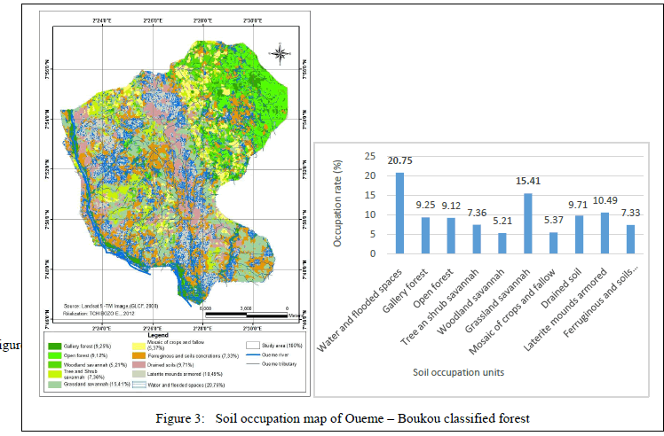
| III.1 MAPPING THE LAND OCCUPATION OF OUÉMÉ - BOUKOU CLASSIFIED FOREST (20,763 HECTARES) |
| III.1.1 IMAGE ENHANCEMENT AND VISUAL PHOTO - INTERPRETATION |
| The raw images obtained from the study area have undergone several treatments visual improvement to enhance the expression of vegetation. The results of color compositions, neo channel NDVI and their optimization are shown in figure 2. |
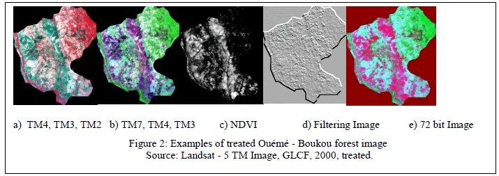 |
| Its analysis shows a varied information level on the processed images. In figure 2a, all wet vegetation is shown in red graduation with little distinction of vegetation. The image in figure 2b provides better visualization of vegetation plants formations that are drawn in several graduations of green. Figure 2c representing the vegetation index, tones sink areas covered and the clear bare soil are remarkable. Figure 2d shows the different strata herbaceous, shrub and tree vegetation. In figure 2e (72 bit images), we can easily distinguish different plants vegetation formations like the image in figure 2b (24 bits), but the importance of contrast, the limitations are more obvious. It is therefore more suitable for this study because the representation of vegetation are made in green and levels rose bare soil. |
| III.1.2 MAPPING OCCUPATION THE LAND BY ASSISTED IMAGE CLASSIFICATION |
| The map of occupation land shows the vegetation unevenly distributed in a humid environment with high presence of water (20.75%) and underthe pressure of desertification (27.53%). Theestimation of Oueme - Boukou classified forest cover is 46.35%. According the forest inventory of Benin (1978), many species are identified. It consists of 9.25% of gallery forest (Pterocarpussantalinoides, Cola laurifolia, Cynometramegalophyllamespiliformis and Diospyros), 9.12 % of woodland (leiocarpusAnogeissus, Combretumcollinum, IsoberliniadokaandPterocarpuserinaceus), 7, 36% of savannah and bush (Combretumcollinum and Lophiralanceolata), 5.21% savannah woodland (Combretumcollinum and Vitellariaparadoxa) and 15.41% of grassland (post group - cultural andBrachiariadeflexaSecurinegavirosa). This latter is the dominant formation of the vegetation. Areas not covered gather ferruginous soil concretions (7.93%), well-drained soils (9.71%) and laterite mounds armored(10.49%). In the middle part, bare corridor drained soils, ferruginous soil concretions and laterite mounds armored divides the classified forest into two unequal parts: In the West, the relatively wet vegetation is represented by relics contrast with large bare surfaces. In the East, the floristic diversity is under by influence of crops and fallow. North - west, vast floodplains are occupied by water. They are shelter a strip of gallery forest, clear forest, tree and shrub savannah, savannah woodland and grassland. On the east bank of Oueme River, a major of desertification area is remarkable. South - west, pressure of fallow and crop has already begun islands gallery forest, savanna tree, shrub and grassland. In North – east, the most abundant woodland is imbued with gallery forest and grassland also under crops and fallow pressure. South - east, grassland and tree with shrub savannah are inundated. On the way, in Oueme - Boukouforest, wet vegetation is dominated by grassland. It is characterized by human and fallow crops pressure with the relatively largest natural flooding. Significant deforestation exposes vegetation plants to fragmentation (figure 3). |
 |
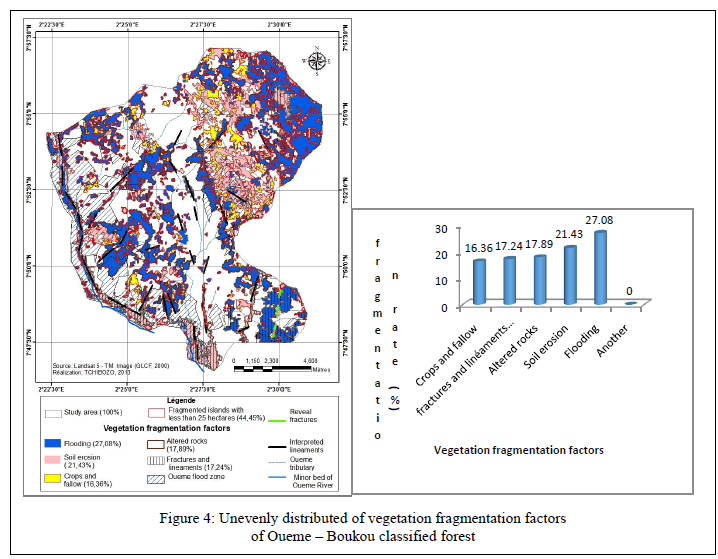
| 3.2 Identification of vegetation factors fragmentation |
| Factors of vegetation fragmentation occupy different space. In Oueme - Boukou classified forest, we distinguish flood (27.08%), differential soil erosion (21.43%), altered rocks (17.89%), fractures and lineaments network (17.24%) and the mosaic of crops with fallow (16.36%). Flooding is the dominant factor of vegetation fragmentation. It is relatively important at large North - west in the riverbed and on the banks of OuemeRiver often inundated during floods period. This phenomenon it’s also noted in center, fractures and lineaments depressions, as well as in North - east of the classified forest. The differential soil erosion is noticed in Oueme valley and North - east of the study area. In South - west, we notice eroded soils of Ouemevalley, wish is particularly strongly distinguished in North –east,onthe flooded areas ofCenter and the South –east, in flooded areas of the main depression fracture, revealed by geological map. Fragmentation by crops and fallow land is in North - east and south - east of the study area. In this part of Oueme- Boukou classified forest,unevenly distributed of vegetation fragmentation factors is shown in figure 4. |
 |
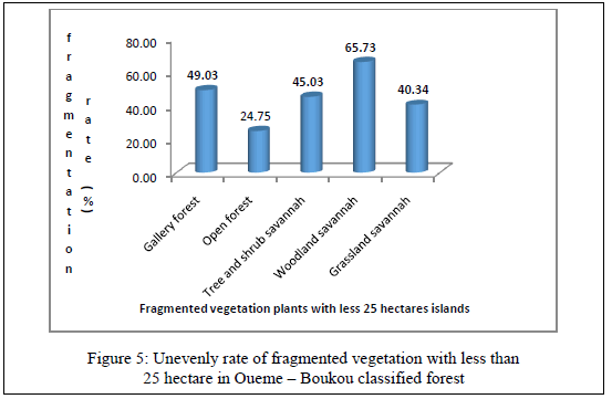
| A portion of vegetation (44.45% or 1,012.94 hectares) is fragmented by islands with less than 25 hectares particularly in North – east (figure 4 and figure 5). Several natural habitats are fragmented at various levels: gallery forest (49.03%), clear forest (24.75%), tree and shrub savannah (45.03%), wooded savannah (65.73%) and grassland (40.34%). Woodland, gallery forest, tree and shrub savanna and grassland habitat are the most affected. The woodland has less fragmented islands (figure 5).To understand this, we must analyze the vulnerability of vegetation factors fragmentation. |
 |
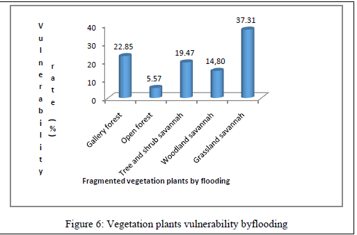
| III.2ANALYSIS OF VEGETATION PLANTS VULNERABILITY |
| In the Oueme - Boukouclassified forest, vulnerability of vegetation is varied and depend of considered factors: - Flooding present important vulnerability levels for grassland (37.31%), gallery forest (22.85%), tree and shrub savannah (19.47%) and woodland (14.80%). Grassland is most vulnerable while the woodland is less sensitive to this natural factor fragmentation (figure 6). |
 |
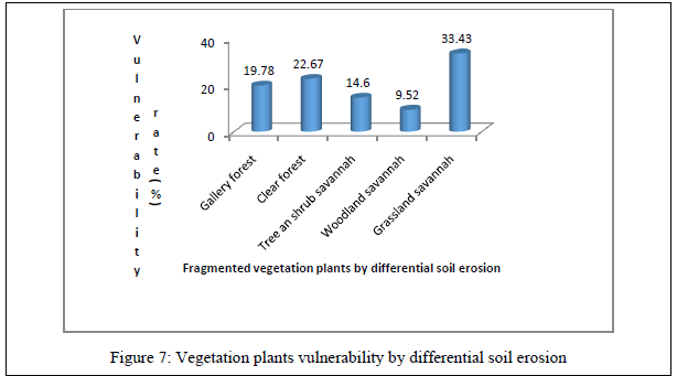
| Differential soil erosion demonstrates high levels of vulnerability for grassland (33.43%), medium to clear forest (22.67%) and gallery forest (19.78%). Grassland is more fragmented while the woodland is less fragmented (figure 7). |
 |
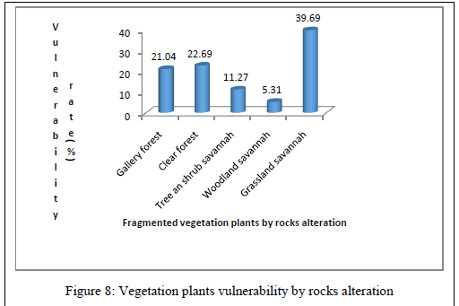
| Rocks alteration fragmented grassland (39.69%), open forest (22.69%) and gallery forest (21.04%). Grassland is more fragmented while the woodland is relatively less fragmented by this natural factor (figure 8). |
 |
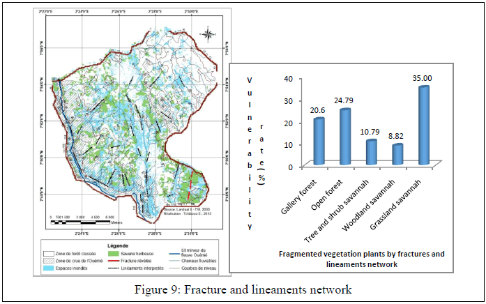
| Fractures and lineaments network realize a high level of vulnerability for grassland (35.00%), open forest (24.79%) and gallery forest (20.60%). The other teams are not vulnerable to this type of fragmentation (figure 9).This figure of fractures and lineaments network map shows a correlation between tectonics fractures and lineaments, water system, flooded areas and grassland (fragmented training) of Oueme - Boukou forest. Indeed, these elements are oriented in the same direction (North West – South East and North East – South West) as flooded fractures and lineaments. This network is relatively dense in west – Center, where we distinguish Oueme River flood areas and flooded vast areas. Flooding is lower in the northwest where the slope of relief is higher. The fractures and lineaments network is less dense at the place, where we notice fragmented islands of vegetation plants less than 25 hectares and grassland not cover soil. |
 |
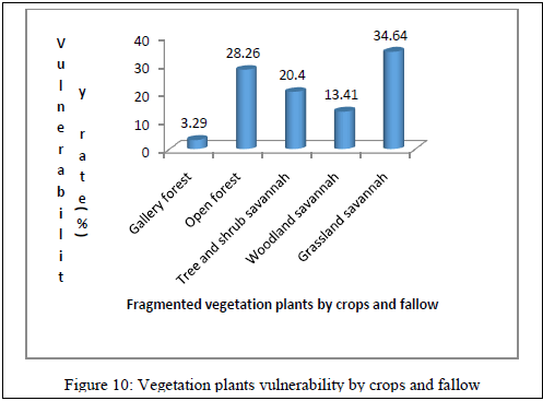
| Mosaic of crops and fallow fragments grassland (34.64%), open forest (28.26%), tree and shrub savannah (20.40%) with woodland (13.41%). Grassland is more fragmented while gallery forest (3.29%) is less vulnerable to anthropogenic factor of fragmentation (figure 10). |
 |
DISCUSSIONS |
| The obtained results show the importance of image visual quality in made mapping of land cover by image classification. The confusion matrix (94.41 %) and kappa index (0.93) used to assess the latter meet the criteria for validation (Chalifoux et al., 2006). According to FAO (2010),the estimation world global deforestation over the period 1990 to 2005 is 13 million hectares per year without significant change, and 70 000 hectares per year for Benin. At the national level, forests are fragmented due by human factors (Sinsin and Kampmann, 2010).But this study showed that in Oueme - Boukou classified forest, anthropogenic fragmentation is associated with the natural factors to fragment vegetation plants. Indeed, we notice a unevenly distribution of vegetation which is characterized by a strong presence of water, with essential element for flood risk, soil erosion and rocks weathering. These factors of fragmentation are dominant in the current study area with significant deforestation, especially for grassland. A portion of vegetation (44.45% or 1,012.94 hectares) is fragmented by islands with less than 25 hectares. Savannas and forests are more fragmented. According Pütz et al. (2011), in tropical areas, below the threshold of 25 hectares, forest structure and biodiversity are fast, deep and lasting affected: mature forest can reappear, only the early stages of the sylvogenetic cycle are maintained. This statement corroborates the results of this study and confirm the various levels of vegetation fragmentation in the classify forest of Oueme -Boukou. |
CONCLUSION |
| In Oueme - Boukou classified forest, wet vegetation is in the under pressure of natural fragmentation factors (flood, differential erosion, rocks weathering, fractures and lineaments network) and anthropogenic factor (mosaic crops and fallow). Large desertification areas are identified, especially at the grassland which is the most fragmented. Part of the whole vegetation classified forest study presents a fragmented habitat with islands less than 25 hectares. Savanna and gallery forest are the most affected. Thus, the vegetation of study forest has varying levels of fragmentation. To control the spectral behavior of the fragmented vegetation, it is a useful information for better management of the Benin classified forests dynamics. More recent data should measure the real dynamics and sense of fragmentation (based on the results of this study), in order to limit its impact on the ecosystem. It would be interest to study the dynamic of grassland savannah which is the most fragmented vegetation plant. This opportunity offers the perspective for the analysis of economic and cultural potential of this classified forest to create metadata and spatial data infrastructure forests.To this end, control of water could help to reduce flooding impact, weathering and differential soil erosion. Measures stricter protection of classified forests are implemented to reduce human pressure. Threatened by tectonic fractures and lineaments areas could be a partial decommissioning study forests and recommended for geological and mining surveys. |
THANKS |
| At the end of this research, we would like to sincerely thank: |
| Brice SINSIN, Rector of Abomey - CalaviUniversity and his team for the financial support that has allowed us to travel to Morocco to present the results of this study. |
| • The Moroccan Association for Youth Geomatics Meeting where this study was presented and approved. |
References |
|