ISSN ONLINE(2319-8753)PRINT(2347-6710)
ISSN ONLINE(2319-8753)PRINT(2347-6710)
R.Gopi1, K.Priyanka2, R.Reshmabegum2, N.Sangeetha2
|
| Related article at Pubmed, Scholar Google |
Visit for more related articles at International Journal of Innovative Research in Science, Engineering and Technology
In a Vehicular Ad-hoc Network (VANET), vehicles communicate with each other and possibly with road-side infrastructure nodes. Node connectivity and the amount of data that can be exchanged are limited by the duration and quality of the communication links established among nodes, which are determined by the space and time dynamics of moving vehicles. We analyze the connectivity dynamics of vehicular ad-hoc networks in a generic signalized urban route. Given the velocity profile of an urban route as a function of space and time, we utilize a fluid model to characterize the general vehicular traffic flow, and a stochastic model to capture the randomness of individual vehicle which is determined by Mesoscopic,and Microscopic mobility model.Mesoscopic is a technique which is used to find time headway between two vehicles and microscopic technique is used to find a distance headway between the two vehicles.
Keywords |
| VANET, Mesoscopic, Microscopic. |
INTRODUCTION |
| To satisfy increasing requirement of enhancing transportation safety and efficiency, vehicular ad hoc network (VANET) emerges.VANETs are expected to enhance the intelligent transportation systems and support not only public safety applications but also a wide range of infotainment applications. It is a special kind of mobile ad hoc networksconsisting of entities including the vehicles, also known as on-board units (OBUs), and the roadside units (RSUs). In a vehicular ad hoc network, the OBUs and RSUs, equippedwith on-board sensory, processing, and wireless communication modules, can form a self-organized networks.A Onboard Unit is a device which is fitted in vehicle to provide any traffic information. Fixed RSUs, which are connected to the backbone network, must be in place to facilitate communication. Dedicated Short Range Communications (DSRC) is a short to medium range communications service that was developed to support vehicle-to-vehicle and vehicle-to-roadside communications. Such communications cover a wide rangeof applications, including vehicle-to-vehicle safety messages and provide a traffic information. In VANET, each vehicle can not only communicate with each other, i.e,vehicle-to-vehicle (V-2-V) communication, but also communicate with roadside unit,i.e., vehicle-to-infrastructure (V-2-I) communication. Therefore, compared with the traditional pure infrastructure-based network, the hybrid of V-2-V and V-2-I communications ispromising since it can not only overcome the disadvantages of infrastructure-based network, but also overcome the disadvantage of non-infrastructure –base network. For example, in VANETs, vehicles move within specific road directions, and the importance of transmission power and message storage space constraints is not limited. Moreover, the geographic location of a vehicle can be determined by using a global positioning system (GPS) receiver, when applicable. |
II.RELATED WORK |
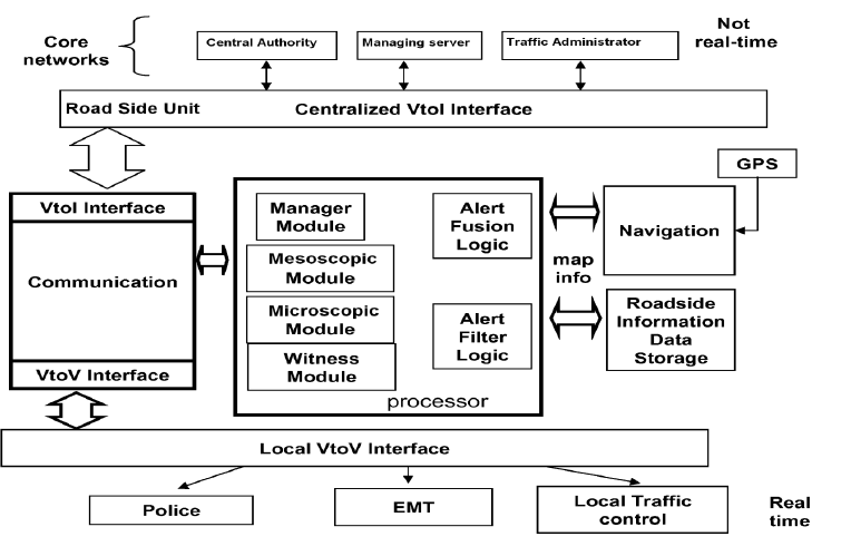
| Traffic incidents and road conditions impact the safety of drivers, passengers, and vehicles. It is desired to disseminate such road related information to using a multi-hop wireless broadcast network to ensure the safety of the vehicles. This can alleviate traffic congestion, speed up medical rescue and provide real-time data acquisition for law enforcement and insurance purposes and also for weather forecasting. The automotive information providing system to vehicles can be done by some steps like, 1.A method for broadcasting witness information related to a vehicular environment using a multi-hop broadcast network of nodes which include a source and a set of relay nodes with transceiver and processor vehicles which is equipped with sensing,broadcasting,receiving and rebroadcasting. 2.The Accident information system providing for an automotive vehicle comprising vehicle position and direction, accident data storing and extracting, drive condition detecting, accident occurrence, alarming. |
| 3.. The accident information providing system of step 2, which comprises detecting vehicle speed; and a radar unit for detecting a distance between the vehicle and another vehicle, said accident occurrence discriminating the possibility of occurrence of a collision accident when the detected distance between the two vehicles is less than a predetermined value according to the vehicle speed detected by speed detecting. |
| 4.The accident information providing system of step 2, which further comprises a wiper switch for detecting rainy weather, said accident occurrence discriminating , when a current driving condition either one of exceeds or is less than a predetermined value of a like driving condition, and by using a predetermined value wiper switch detects rainy weather. |
| 5.A method of providing accident information to a driver, comprising the steps of: (a) calculating current vehicle position and current vehicle travel route on the basis of map data and travel position and direction sensor outputs by mesoscopic, microscopic mobility model. |
| Mesoscopic model: Time headway, which is the elapsed time of the passage of identical points on two consecutive vehicles. In this concept, VANET uses as car a mobile node to communicate with each other. We find the time headway between the two nodes. There are three flow conditions: uncongested flow, congested flow and Near-capacity flow. The uncongested flow condition defines low vehicles density. This defines there is no traffic between vehicles and exponential probability distribution is used. The congested flow condition defines high vehicles density. This defines there is many traffic between vehicles and Gaussian distribution is used. The near-capacity flow condition defines intermediate vehicles density. This defines there is medium traffic between vehicles and Pearson distribution is used. By finding this flow densities i.e., ranges we will estimate the link and improve link life time between the nodes. |
 |
| (b) Estimating vehicle travel direction; (c) Referring to accident data related to the estimated vehicle travel direction to check whether a frequent accident occurrence point exists ahead of the current vehicle position; (d) if the frequent accident occurrence point exists, referring to the accident data to check a type of past accident which occurs at the frequent accident occurrence point; (e) Detecting vehicle driving conditions; (f) Checking whether the detected vehicle driving conditions are dangerous by comparing the detected conditions with the checked type of past accident; and (g) if the detected conditions are dangerous, outputting an accident alarm. |
| 6. The method of providing accident information of step 5, wherein: (a) if the checked type of past accident is a right/left accident in step (d) of step 5, detecting whether a flasher lamp is turned on; (b) if the flasher lamp is turned on, checking whether the turned-on flasher lamp direction matches a turn-accident direction of the checked type of past accident; and (c) if the turned-on flasher lamp direction matches the turn-accident direction, outputting a turn-accident alarm. |
III. PROPOSED METHODOLOGY AND DISCUSSIONS |
| Information related to a vehicular environment is disseminated in a multi-hop broadcast network of nodes. An event is sensed at a location by a source node. In response, zones are associated with respect to the location of the source node. An alert message is broadcast, received, and then rebroadcast by other vehicles according to the locations of the vehicles in the zones. The nodes can also disseminate witness information. |
| Its major contributions accident information system Convey the alert message or call to police station, ambulances when accident is occured.This system can also intimate about the live formations of weather forecasting. |
IV.SYSTEM ARCHITECTURE |
 |
V.EXPERIMENTAL RESULTS |
 |
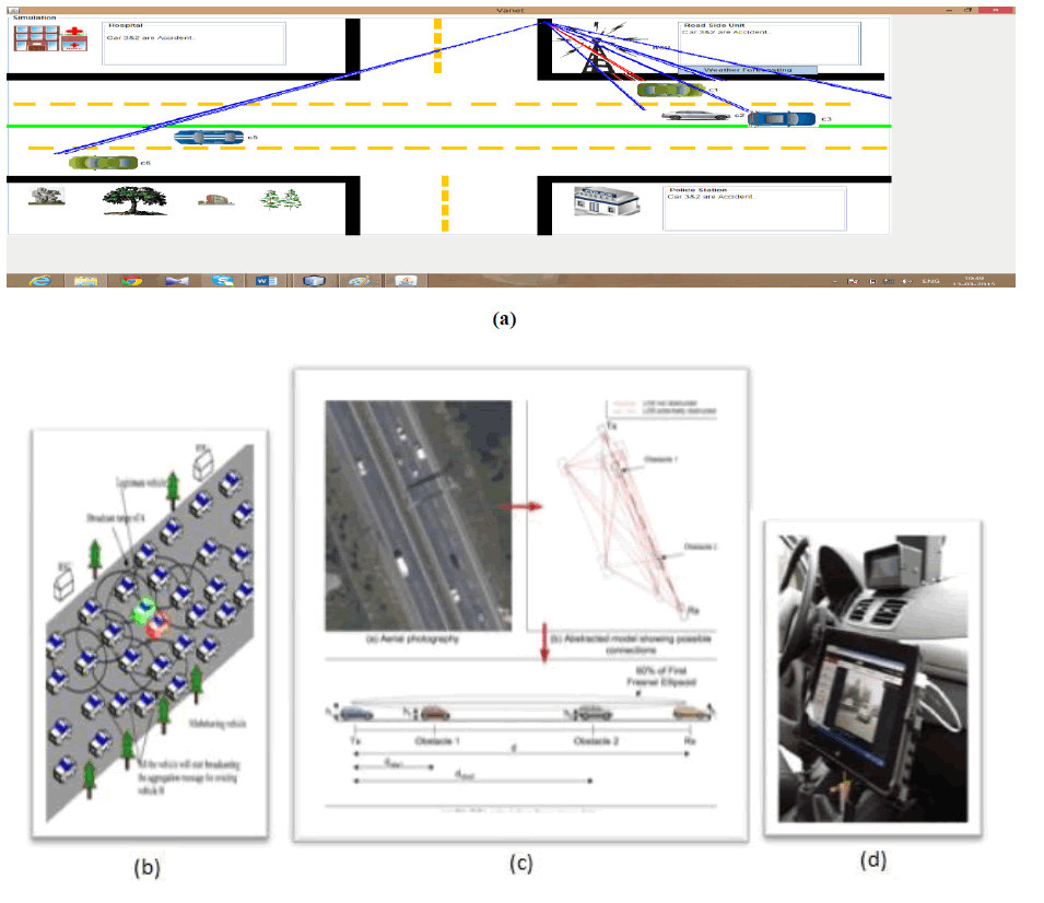
| figure shows the automotive accident information system which can be broadcasted using multi-hop .network and fig (a) represents the overall information system of an automotive vehicle which provides the accident information and witness information about the weather. The blue line represents the rainy detected zone which intimated to all cars. Fig(b) and (c) represents the multi-hop broadcast network and the inter-vehicle distance can be calculated. Fig(d) represents the car equipped with VANET device |
VI.PERFORMANCE ANALYSIS |
| Performance evaluation shows that this scheme is more efficient in terms of link life time. To analyze the average the communication link length with different number of vehicles in the communication range.The mobility models are used to evaluate the performance of automotive model, in terms of the average multi-hop delay, multi-hop message progress, and dissemination speed. In addition to the analytical models, we also conduct simulations to further evaluate the performance of 3P3B in terms of the average hop count, end-to-end delay. |
 |
VII.CONCLUSION |
| This paper presents a probability detection of multi-hop communication link using vehicle mobility model. The vehicle mobility model which is used to find the distance headway and time headway between two nodes. Mesoscopic is used to find the time headway between two nodes. Microscopic model is used to find the distance headway between two nodes. A DSR(dynamic source routing) which is used to find discover the route and maintain the route between the two nodes. A steady state is used to send any traffic information at a constant time to any node in order to avoid any accidents. Microscopic model does explicitly describe changes occur describe impacts of lane changes on the time variations of distance headways. Communication link lifetime is at least equal communication hop length increases. |
References |
|