International Journal of Innovative Research in Science, Engineering and Technology
ISSN ONLINE(2319-8753)PRINT(2347-6710)
ISSN ONLINE(2319-8753)PRINT(2347-6710)
Magda M. Abdellatif 1, Nadia. M.Sirag2
|
| Related article at Pubmed, Scholar Google |
Visit for more related articles at International Journal of Innovative Research in Science, Engineering and Technology
The present study uses Geographic Information System(s) (GIS) as a spatial decision support tool to select potential sites in Egypt for deep geological disposal for spent radioactive fuel. A specific weight is given to each criterion according to its relative influence on the process of decision making. The results from the application of the presented methodology determine the relative suitability of sites for deep disposal of radioactive wastes. These sites are ranked in descending order to help decision-makers in Egypt. The present study aims to provide a baseline for more detailed technical analyses for the selected sites
Keywords |
| Deep Geological Disposal, GIS, Spent Fuel Disposal, Western Desert of Egypt. |
INTRODUCTION |
| There exists today an international consensus on the appropriateness and capability of deep geologic disposal to provide long-term isolation of used fuel and HLW from the biosphere. This consensus has emerged from more than five decades of scientific study and peer-review, technical and regulatory developments, and site selection and characterization. |
| International efforts over the last half-century toward disposal of high-level waste and spent nuclear fuel have primarily focused on mined repositories. Nonetheless, evaluations of deep borehole disposal have periodically continued in several countries [OâÃâ¬ÃŸBrien et al., 1979; Woodward and Clyde Consultants, 1983; Juhlin and Sandstedt, 1989; Heiken et al., 1996; NIREX, 2004; Anderson, 2004; Gibb et al., 2008]. After many researches in different countries it was concluded that geological disposal remains the only scientifically and technically credible long-term solution available to meet safety needs without reliance on active management and there is overwhelming international consensus on geological disposal as preferred option. Egypt has recently initiated plans to build nuclear power reactors. This program will eventually have to deal with spent fuel and high level waste disposal, as will be seen, deep borehole disposal is a promising approach. On the other hand spent fuel from the research reactor in Egypt stored near the reactor waiting for final solution. As well as the high-level wastes generated from RPF (Radioisotopes Production Facility). At the present early stage of the deep geological repository programme in Egypt, no repository site has been selected, nor has any particular kind of sites been specified as a preferable repository host rock. Therefore, this paper aims to specify generic sites in Egypt by using the previous field studies and GIS program. The potential geological formation properly characterized elsewhere in the world; salt, clay, volcanic tuff, granite and crystalline rocks; most of them are present in Egypt. |
| The present work demonstrated the available data, well logging data and subsurface borehole geological cross sections from the technical research papers. In this work we start to identify geological environments that illustrated all the main hydrogeological settings, large-scale geological structural features (such as sedimentary basins, areas of high relief and so on) and lithological variations occurring in Egypt. The initial list was then checked against the list of possible radioactive waste repository sites and geological environments considered by overseas waste disposal agencies. To ensure that coverage was comprehensive, geological, seismic, hydrogeological and tectonic/structural maps of Egypt were then reviewed. The list was then screened to remove environments where all of the examples in Egypt would definitely be excluded by the general safety criteria [8]. This would be the first step as the potential sites chosen will be need technical and detailed investigation to insure the safety requirements. The main goal of the present study is an attempt to determine the potential sites for spent fuel disposal in Egypt. |
| Egypt is situated in the northeast of the African. It has an area about 1001449 km2 and occupies nearly one-thirtieth of the total area of Africa. Without the Nile Valley and Delta, Egypt is mainly a desert country [9]. |
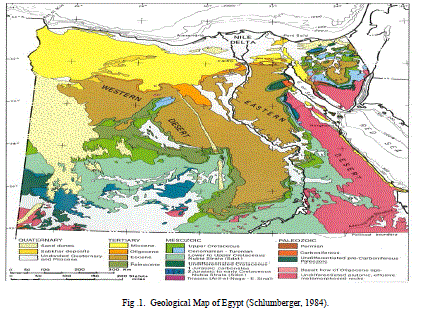 |
| Geographically, the country is composed of several distinct regions; The Sinai Peninsula covers an area of some 61,000 km². The Gulf of Suez covers an area of about 25,000 km². It extends along a northwest trend from latitude 27°30‘N to 30°N. The Eastern Desert embraces the area is about 22% of the total area of Egypt. The Nile Valley and Delta form the alluvial system that stretches for 1530 km². It contains the rich agricultural and industrial area of Egypt and is also the most densely populated part of the country. The Western Desert, with its 680,000 sq km covers more than 65% of entire Egypt. Geomorphologically, it is stone desert plateau with numerous large and deep, closed topographic depression. [Sestini, 1995] Figure [1] shows the geological map of Egypt representing wide range of different geological depositions from the Quaternary deposits to the Precambrian intrusions. These deposits varied from unconsolidated sand dunes to hard igneous rocks. The western desert represents generally wide area of plain plateau with five depressions. |
II. GENERAL GEOLOGICAL SETTING OF EGYPT |
| Structurally, Egypt can be divided into two main divisions: the Arabo-Nubian massif and the so-called shelf areas [Said, 1962; Schlumberger, 1984; Said, 1990] The Arabo-Nubian massif is a stable tectonic unit consisting of the exposed basement rocks in the Eastern Desert, in the southern part of the Sinai Peninsula and in isolated outcrops of southern Egypt [Said, 1962; Schlumberger, 1984; Said, 1990]. The Stable Shelf is a belt extending from southern Egypt to a northern limit arriving as far as the central Sinai. It is characterized by low structural relief and a sedimentary cover of fluvio-continental and marine deposits mainly of Mesozoic to Early Tertiary age, deformed by several sets of regional folds [Said 1962; Dorre et al.,1979; Said, 1990].The Unstable Shelf occupies almost all of northern Egypt (the Nile Delta area is part of the unstable shelf), characterized by a northward-thickening sedimentary section underlain by high basement relief due to block faulting. According to review of topographic maps, structural maps, hydrological maps and the previous researches in technical papers Egypt can be classified as follow; - Areas with low relief; Nile and delta |
| Areas with high relief as; Eastern Desert, south of Sinai and part of the southern west of Western Desert. - Areas with fresh water resources; Nile and Delta region and Egyptian Depression (El-Kharge, El- Dakhla, Elfrafra, Siwa, Qattara) - Under ground water source (Nubian Sandstone Aquifer); this great aquifer expand in four countries (Egypt, Libya, Chat and Sudan) - Areas with relatively high seismic activities; area near and around the Suez Gulf area. - Areas with high population density; Nile and Delta region |
| According to the hydrological setting as an important criterion the depth of the water table must be taken into consideration as a highly important factor, since we consider deep disposal for spent fuel. The aquifers system in Egypt is classified into two types. The first type is the granular aquifers system, which includes the Nile Valley and Delta aquifer, coastal aquifer, Nubian Sandstone aquifer, and Moghra aquifer [15]. The second type is the fissured aquifer system, which includes the Fissured Carbonate aquifer. It is considered to be one of the poorest aquifers in Egypt. It belongs to different geological ages and consists of shale and sandstone layers. [15]. |
| Nubian Sandstone aquifer has a thickness varying from less than 500 m to more than 3000 m and rests directly on Precambrian basement. [16, 17] The thickness of the Nubian Sandstone is very important factor affecting the choice of a disposal site in Egypt, since this formation is the main source of the underground water source which would be great contribution in the future development in our country. There was a proposal for future development in some locations depending on the water resources represented in Nubian sandstone aquifer [17] since the Nubian sandstone covers the area near the surface in some locations. A large area of about 3.5 million Fadden is able to be developed [18-21]. Figure [2] shows the Nubian Aquifer and the main features of hydrogeology in Egypt; where the water flows of the main aquifer from south to north direction. The direction of water flow is an important factor in the evaluation of waste disposal site. As we see the Nubian deposit thickness decreased from the north to the south and the Nubian Aquifer cover four countries (Egypt Libya, Chad and Sudan). |
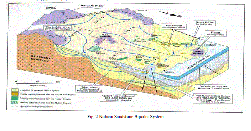 |
| The main western system, which extends into Libya and Sudan, comprises a multi-layered artesian basin where huge groundwater storage reserves were accumulated, principally during the fluvial of the Quaternary. [17] |
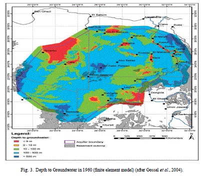 |
| Figure [3] represented the depth to ground water; accordingly the water presents at different depths which increases southward, where the desert is hyper arid environment especially the south west region. The Nubian Sandstone formation lies directly on basement rock formation. The depth of the ground water, increases greatly in Gulf el-Kabir area; south west of the western desert. In some location the ground water presents near the surface as in the Depressions. Seismic activity is an important criterion; the more stable area is the safer site for disposal. Earthquakes are the most evident manifestations of the currently occurring bedrock deformation; the seismic activity is very low and is concentrated offshore near and around the Suez Gulf area [23]. On this respect and as the most economically oil field is situated there, Suez Gulf area in eliminated from consideration. So the same will be for Sinai area as it is highly affected by the regional forces related to the Gulf of Suez, and Red Sea tectonics. |
III. APPROACH TO IDENTIFYING GEOLOGICAL ENVIRONMRNTS |
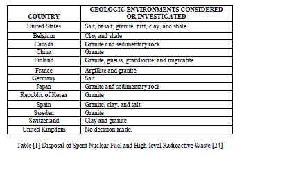
| Despite widely varying territorial area, geology and long-term tectonic stability, implementers of geologic repository programs in all countries reviewed are confident of identifying one or more locations suitable for geologic disposal. Egypt as a continental nation has a diverse set of rock formations, including most of those under consideration by programs in other nations (Table 1): ‘crystalline rock’ (igneous and metamorphic rock), salt formations, and impermeable argillaceous (clay/shale/argillite basins-containing) sedimentary formations. Table [1] show the geological environments considered in thirteen countries started their disposal program in deep disposal. |
 |
IV. METHODOLOGY |
| Acceptable Generic Sites: A generic site is one that is well-suited to the task at hand and also widely available geographically and geologically. In general, granitic bedrock overlain by an average (but highly variable) two km or so of sedimentary rock is widely present in Egypt. This suggests consideration of sites having about one kilometer of sedimentary overburden. Furthermore, we adopt the common practice of designating igneous continental bedrock as “granitic,” even though it may be in its metamorphosed form of gneiss or in its glassy version of a rapidly-cooled rhyolite. The key attribute of all is their exceptionally low permeability with regard to water transport. On-land basalts however should be considered as an alternative host rock. |
| In Shales and Argillaceous media potential host formations, a repository site could readily be located with attributes such as those identified by Shurr [1977]: |
| - Shale thickness – Maximum thickness of the isolation medium is desired, while a minimum thickness of 150 m is preferred. - Overburden thickness – Minimal thickness of overlying geologic units is preferred. - Lithography and mineralogy – The potential repository interval should be reasonably uniform clay or shale. - Penetrations (boreholes) – Boreholes of any kind are undesirable, particularly if they penetrate to rocks beneath the disposal horizon. It is recognized that some holes, either preexisting or bored during detailed search for isolation sites, are necessary to provide geologic information at depth. - Structure – The disposal zone should have nearly horizontal bedding, with no significant faulting or folding in the vicinity of the isolation site. - Seismicity – Preference would be given to regions known to be inactive from recorded - Topography – Minimal topographic relief is desirable to limit subsurface hydraulic gradients. - Mineral and water resources – It is undesirable to consider a potential site near exploitable mineral or water resources, either at or below the surface. |
| The selection of potential disposal site according to different criteria and previous experience with different rock types need an overview of the regional geology of the country as a first step followed by weight value method. The Open Decision Maker [ODM] is designed to support a user in a decision making process. For this process ODM uses the Analytic Hierarchy Process [AHP] method. This method is similar to the value benefit method, but it also compares the rating quality for all comparisons and shows the consistency of the decisions which have been made. In this study Egypt is classified in terms of zonal areas; which are evaluated according to the primary criteria for radioactive waste disposal. The ranking of these zonal areas is done moving the control in the wanted direction. It is possible to choose between 9 different weightings (the Saaty Rating Scale) table [2]: |
 |
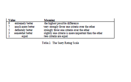 |
| The highest value means the highest possible favor choice; the low number means the two criteria are equal importance. A number of input criteria are used that influence the choice of waste disposal sites. The first step in the methodology requires the development of a digital GIS database containing spatial information. A number of thematic maps are prepared from topographic maps, hydrologic maps (aquifer depth), seismic map, structural map, population density map, natural resources map, climatic map and previous reports. The thematic maps represent topography, structural, aridity, climatic changes, earthquakes, hydrology (aquifer depth), population density, natural resources… The weight of each factor was based on its estimated significance. Based on the weight of each factor and its class, the input rasters are weighted by importance and added together to produce an output raster. The steps are summarized below: 1. A numeric evaluation scale of 1–10. 2. The cell values for each input raster in the analysis are assigned values from the evaluation scale and reclassified to these values. This makes it possible to perform arithmetic operations on the rasters that originally held dissimilar types of values. 3. Each input raster is weighted, or assigned a percent influence, based on its importance to the model. The total influence for all rasters equals 100%. 4. The cell values of each input raster’s are multiplies by the raster’s weights. 5. The resulting cell values are added together to produce the output raster. In this study number of criteria are used; seismic activities (frequencies, magnitude), hydrology (aquifer depth), rock formations (type, depth), climatic change (aridity index), population density (human activities'), natural resources (future activities). These input criteria are used that influence the choice of sites. AHP (Analytical Hierarchy Process) is a structured technique that helps decision-makers to find a site that best suits their goal and their understanding of the problem. |
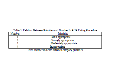
| In this paper, ODM based on simple additive weighting criteria were used to support spatial decision making. AHP assists the decision makers to simplify the decision problem by creating a hierarchy of decision criteria that best suits their goal and their understanding of the problem, table [3]. Number one represents the most appropriate choice while number 4 means the choice inappropriate. We arranged the proposed sites according to these numbers. The procedure for using ODM can be summarized as follows: model the problem as a hierarchy containing the decision goal, the options for reaching it, and the criteria for evaluating the options; establish priorities among the elements of the hierarchy; synthesize these judgments to yield a set of overall priorities for the hierarchy; check the consistency of the judgments; come to a final decision based on the results of this process [25]. |
 |
V. RESULTTS |
| Rock types in Egypt: From the review of the previous technical science paper concerning the stratigraphic cross section and tectonic structural in Egypt and according to the suitability of certain rock formation for radioactive waste disposal (salt, clay formation, tuff and granite) and the acceptable generic site we found that: |
| Salt deposits are found in different formations, major occurrences of salt dome in different countries are found along the gulf coast, these formations are not found in our land. Usually salts in Egypt are formed as sheets on surfaces of land near the coastal areas. |
| Tuff rocks; the volcanic and volcaniclastic rocks covering vast areas in the Eastern Desert of Egypt are represented by metavolcanics and Dokhan volcanics. The Dokhan volcanics are most abundantly occurring in the Northern part of the Eastern Desert of Egypt and related to Late Proterozoic products of the Pan-African volcanism in the Nubian Shield. These Dokhan volcanic rocks constitute agroup of calc-alkaline extrusion and well developed in various parts of the Eastern Desert. [26,27] |
| Clay mineral deposits are widely distributed in Egypt, covering all geologic ages span from the early Paleozoic up to the present. Shale is often used as a very general term of all kinds of clay rich sedimentary rocks. Shale are accounting for around 60% of the stratigraphic column. Clay minerals account 50-60% of most shale. In Egypt shale are usually deposited in wide area and various thicknesses. Their thickness range from few centimeters to few hundred meters in different formation (e.g.Khatataba formation, Alam El-Bueib formation, Abu Roash formation). Most shale formation as the Khatatba Formation comprises sandstone and organic-rich shales that show source rock potential for hydrocarbon generation (Alsharhan and Abd El-Gawad, 2008; Shalaby et al., 2011) |
| Granitic rock, granitoid rocks are widely distributed all over the Egyptian Shield, constituting approximately 60% of its plutonic assemblage. They range in composition from quartz diorite and tonalite, through granodiorite and quartz monzonite to normal granites and alkaline–peralkaline granites [30]. |
| Finally attention has been focus into granitic type rock because of its widespread continental presence (especially if several hundred meters of sedimentary overburden is tolerable) and its superior physical properties: low porosity and permeability, in particular. |
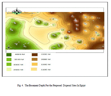
| In Egypt the most appropriate area for radioactive waste disposal according to this study would be the south part of the western desert (the most hyper-arid environment) generally between 22âÃÂð and 26âÃÂð N Latitude and 26âÃÂð and 30âÃÂð E Longitude. In this are there are four potential sites ranking as the following in table [4]. |
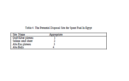 |
| The four potential sites are located in the western desert of Egypt figure [4]; in the south west part. The depth decreased towards the east and north. The four proposal site located in the south west area in the western desert where the Granitic rocks (basement complex) found in depths between 1100-4000 km. These sites represent one type of rock (granitic rocks). The present study could be considered as a baseline for more detailed technical analyses for the selected sites. As well as we recommended more investigation for the clay formation in Egypt, since it need more investigation as a second choice for radioactive wastes disposal. |
VI. CONCOLUSION |
| The present study uses Geographic Information System(s) (GIS) as a spatial decision support tool to select potential sites in Egypt for deep geological disposal for spent radioactive fuel. The research demonstrated all the geological information in most of the scientific research papers, the geological maps, and the available stratigraphic cross section for different areas all over the country. Aridity, deep aquifers, earthquakes, population density, topography and natural resources are criteria that have been taken into consideration in the process of analysis. A specific weight is given to each criterion according to its relative influence on the process of decision making. The results from the application of the presented methodology determine the relative suitability of sites for deep disposal of radioactive wastes. These sites are ranked in descending order to help decision-makers in Egypt. The present study aims to provide a baseline for more detailed technical analyses for the selected sites. |
References |
|