International Journal of Innovative Research in Science, Engineering and Technology
ISSN ONLINE(2319-8753)PRINT(2347-6710)
ISSN ONLINE(2319-8753)PRINT(2347-6710)
| V.S. Pawar-Patil 1, Sagar P. Mali 2 Assistant Professor, The New College, Kolhapur, India 1 Project Fellow, UGC Major Research Project, Dept. of Geography, Shivaji University, Kolhapur, India 2 |
| Related article at Pubmed, Scholar Google |
Visit for more related articles at International Journal of Innovative Research in Science, Engineering and Technology
It is proficiently important to conserve the limited and precarious natural resources vis land, water and soil which should be categorically studied at watershed level. Due to improper land, soil and water management practices, land and water resources getting degraded and eroded, water getting polluted. In this regard present study is profoundly concerned to characterization and prioritization of Tulasi sub watershed which is small tributary of Bhogavati River in mega Panchganga river basin of Kolhapur district, Maharashtra. The prioritization of this small watershed has been carried out on the basis of morphometric analysis for land reclamation and soil erosion prevention. Database has been prepared in ArcGIS 9.3 desktop application, ARCSWAT extension tool for sub-watershed demarcation and other analysis carried out for certain significant areal, linear morphometric parameters vis stream length, stream frequency, bifurcation ratio, Length of overland flow, perimeter of basin, drainage density etc. have been assessed. Cartosat data used for preparation DEM and delineation of watershed. Above said parameters obtained by using Arc Gis ver.9.3 software and appropriate weightage assigned to them in order to assess the priority of sub watershed. The result reveals that, sub-basin TB-2, TB-3 and TB-4 has comes under the high risk for soil erosion and need to give a high priority for land conservation practices. These studies are significant for soil erosion prevention and surface rainwater harvesting.
Keywords |
| Watershed, GIS, Morphometric Analysis, Prioritization |
INTRODUCTION |
| It is proficiently needed to maintain the precarious natural land and water resource which should be prominently done at micro watershed level. The importance of the morphometric analysis of drainage basin is pivotal concerned to understand the geological and geomorphic behavior of drainage basin which influences the soil erosion characteristics in the basin. The future of human being is closely attached with the proper development and conservation of natural resource like Soil and water; hence natural resources have prime importance (Panhalkar, et al 2012). In this regard prioritization of watershed on the basis of quantitative analysis of morphometric parameters are crucial one in order to decide sustainable watershed development strategy. The quantitative analysis of morphomertic parameters is of immense utility in river basin evolution and watershed prioritization for soil and water conservation at micro level watershed (Kanth and Zahoor 2012). The predominant drainage lines originated in certain watershed which influenced by climate, geology and anthropogenic behavior, have become the major issue of discussion among the scholars. In view of the above remote sensing and Gis techniques got paramount importance in sustainable micro watershed management. Morphomertic analysis of basin incorporates a quantitative description of drainage network which is important for prioritization of watershed (Strahler, 1964). The remote sensing technique is a convenient method for morphomertic analysis as the satellite images provide synoptic view of the large area and is very useful in the analysis of drainage basin morphometry (Javed et. al. 2009). Concrete work on drainage basin morphometry and characterization of watershed has methodologically attempted by Strahler (1957), Nag (1998), Thomas et al (2010) and Mishra and Nagrajan (2010). Gis techniques are now days used for assessing various terrain and morphometric parameters of the basin, as they provide a flexible and powerful tool for the manipulation and analysis of spatial information (Pareta and Pareta 2011). Concerned to this several scholars have attempted to work out this study with geospatial approach. Pareta Kuladip et al (2011) have studied the quantitative morphometric assessment of Yamuna watershed by using Aster Dem data and Gis techniques. Dutta shymal et al (2012) evaluated the erosion surfaces and stages of evolution of Sangra drainage basin in Giridhi district of Jharkhand. The objective of the present study is to characterize and prioritize the Tulasi micro watershed on the basis of morphometric characteristics. |
II. STUDY AREA |
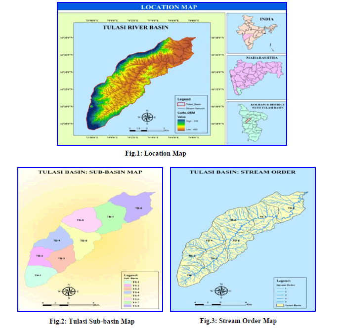
| The Tulsi basin, a main tributary of River Bhogawati in Panchganga mega river basin occupying part of Karvir & Radhanagari talukas of Kolhapur district, Maharashtra which extends from 16° 27âÃâ¬ÃŸto 160 39 North latitude and 73° 57âÃâ¬ÃŸ to 740 08âÃâ¬ÃŸ East longitudes is selected as study area for present paper. It covers about 165 Km2 areas and flowing from southwest to north east direction. It is one of the fertile and well-watered parts of south Maharashtra. |
 |
III. DATABASE AND METHODOLOGY |
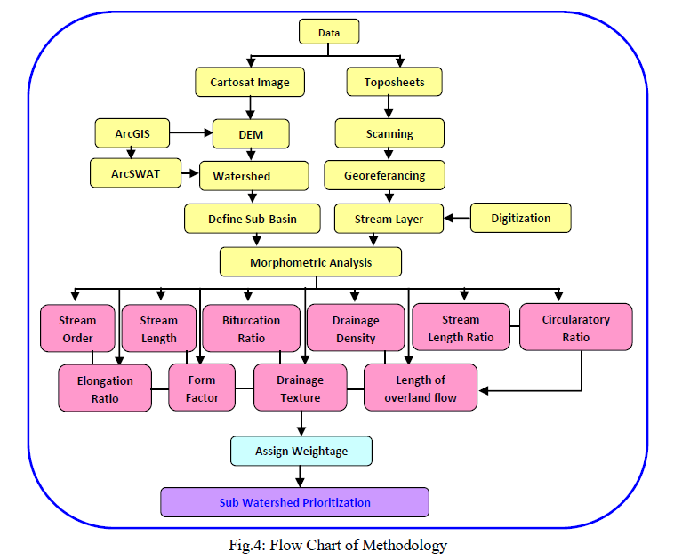
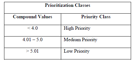
| The present study mainly concerned to evaluate morphometric characteristics of river basin at sub watershed level in order to assess the prioritization of Tulasi micro watershed with geospatial techniques. To do the same both SOI (Survey of India) Toposheets (47 H/14 & 15, 47L/2 & 3) and Cartosat DEM data (30 m resolution) were used in Gis environment. At the outset, Cartosat data used as input in ArcSWAT and delineate main watershed as well as eight sub watersheds. Georeferancing of toposheets were done in Arc Gis 9.3 ver. Software and mosaic the same in order to subset the study region. The rectification method has been employed to obtain geometrically corrected subset image. Certain morphometric characteristics like as area, perimeter and length, stream orders and numbers of the streams were directly calculated in software. Standard methods of StrahlerâÃâ¬ÃŸs, HortonâÃâ¬ÃŸs, MillerâÃâ¬ÃŸs and SchummâÃâ¬ÃŸs were applied to examine morphometric characteristics. Each single morphometric element is considered in prioritization of watershed and weightage has assigned. Avery single parameter has assigned the weight as per morphometric results. For linear aspect, high weightage has assigned for high values and aerial aspect low weightage assigned for high values (Panhalkar, Pawar 2012). The compound values of all parameters at sub watershed level were calculated and highest priority has assigned to sub watershed having lowest average compound weightage and vice versa. Here the priority shows the necessity of land resource conservation and need to be implementing appropriate reclamation methods |
 |
IV. RESULT AND DISCUSSION |
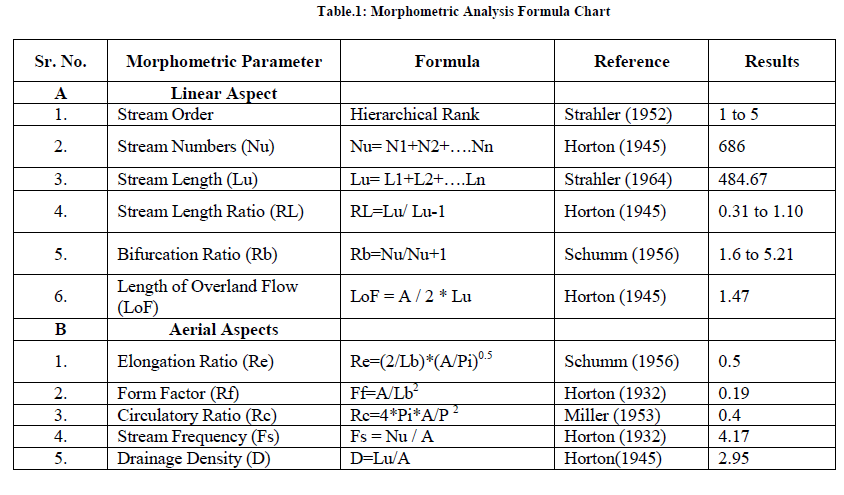
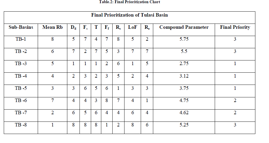
| The prioritization of Tulasi watershed at sub basin level has carried out on the basis of morphometric characteristics. 8 sub watersheds have been generated in ArcSWAT software having geographical area of about 13 Km2 to 27 Km2. Fluvial work of drainage network greatly control the evolution of erosion land forms in basin. Details of morphometric analysis of Tulasi watershed has enumerated in table 1. |
| I) Linear Parameters |
| Linear parameters of river network include Stream order (U), Stream numbers (Nu), Stream length (Lu), Stream length ratio (RL), Bifurcation Ratio (Rb) and Length of overland flow (Lof) |
| The first and most important parameter in drainage basin analysis is ordering, whereby the hierarchical position of the streams is designated (Kanth et al 2012). The consept of stream ordering has firstly put forwarded by Horton (1945), but Strahler (1952) had made some modifications and proposed it latter. The Stream ordering is a measure of stream branching in watershed. A first order stream is an unbranched tributary, a second order stream is a tributary formed by two or more first order streams. A third order stream is a tributary formed by two or more second order tributary. In general, an Nth order streams is a tributary formed by two or more streams of order (N-1) and streams of lower order. Tulasi River has 5th order stream and highest number of first order streams observed in sub basin TB-5. The sub basin wise analysis indicates that TB-4, TB-5, TB-6, TB-7 and TB-8 have 5th order stream so these are considered for further analysis. |
| Stream Length (Lu): |
| Stream order wise stream length has computed in Gis environment and HortonâÃâ¬ÃŸs stream length law has employed for the same. Stream order wise stream length exhibits that total stream length decreases with increasing order. The total stream length of all order segments in Tulasi Watershed is 484.67 km. and highest length of first order stream observed in TB-5 sub watershed i.e. 45.92Km. the 5th order i.e. highest order stream length is maximum in TB-8 i.e. 12.59Km. |
| Stream Length Ratio (RL): |
| The stream length ratio is the ratio of mean of segments of order (Lu) to mean of segments of next lower order (Lu-1) (Horton 1945). The stream length ratio of Tulasi basin ranges in 032 to 1.10 and changes of stream length ratio from one order to another indicating their late youth stage of geomorphic development (Sing and Sing, 1997). The 5th order stream length ratio observed in TB-5 and TB-6 i.e. 1.07 and 1.20 respectively. |
| Bifurcation Ratio (Rb): |
| The bifurcation ratio is the ratio of the number of the stream segments of given order „NuâÃâ¬ÃŸ to the number of streams in the next higher order (Nu+1) (Schumm, 1965). Bifurcation shows a small range of variation for different regions or for different environment except where the powerful geological control dominates (Srtahler, 1957). The Bifurcation ratio (Rb) at basin level and sub watershed level has been carried out in Gis environment. In Tulasi basin Rb ranges from 1.6 to 5.21 and the mean Rb in sub watersheds fluctuates from 2.87 to 4.94. The TB-7 and TB-8 are having highest Rb which exhibits low permeability and structural control over it. |
| II) Aerial Aspects |
| Form Factor (Ff): |
| Horton (1932), stated that form factor is the ratio of basin area to square of the basin length. This is an important dimensionless property which enumerates the shape of the basin. Form factor of Tulasi basin is 0.19 and it ranges from 0.41 to 1.05 in sub basins. TB-1 with highest form factor i.e. 1.05 showing high peak flow of shorter duration. Lowest form factor observed in TB-8. In short the shape of the watershed is quite elongated. |
| Elongation Ratio (Re): |
| „Elongation ratioâÃâ¬ÃŸ (Re) is the ratio of diameter of a circle of the same area as the basin to the maximum basin length (Schumm, 1965). According to Strahler this ratio ranges from 0.6 to 1.0 over varied climatic and geologic types. The elongation ratio runs between 0.42 and 1.16 in all sub basins. The lowest and highest elongation ratio reveals in TB-2 and Tb-6 respectively. It reveals that Tulasi basin is having high relief and steep valley sides. |
| Circulatory Ratio (Rc): |
| Circulatory ratio is dimensionless quantity which defined as the ratio of watershed area to the area of a circle having the same perimeter as the watershed and it is pretentious by the lithological character of the watershed. According to Miller (1953) the circulatory ratio having basin ranges 0.4 to 0.5 indicates basin is strongly elongated and highly permeable homogeneous geologic material. The circulatory ratio of Tulasi watershed is 0.4 and in sub watershed level it fluctuates from 0.42 to 0.83, which shows that Basin is highly elongated, low discharge of runoff and highly permeability of sub soil. |
| Stream Frequency (Sf): |
| The stream frequency is defined as the total number of stream segment of all order per unit area (Horton, 1932). Generally high stream frequency is related to impermeable sub surface material, sparse vegetation, high relief and low infiltration capacity of the region. Tulasi basin has 4.17 stream frequency and it varies from sub basin to sub basin. The highest and lowest stream frequency occurred in TB-3 and TB-8 sub basins respectively. |
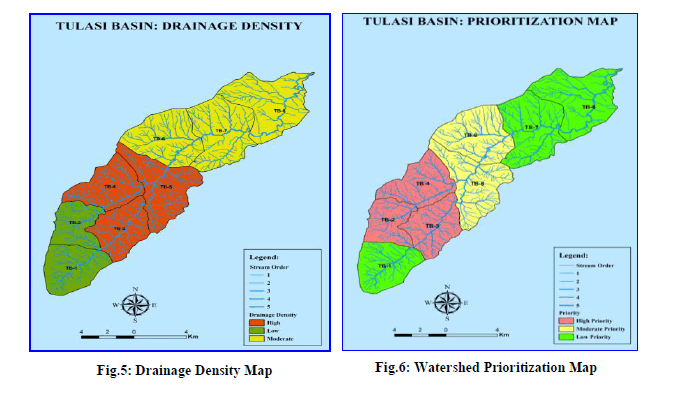
| Drainage Density (Dd): |
| Drainage density is the stream length per unit area in a region (Horton, 1945, Strahler, 1952). It is vital element of drainage morphometry to study the landscape dissection, runoff potential, infiltration capcity of the land, climatic condition and vegetation cover of the basin. |
| The authors have calculated drainage density of whole Tulasi basin, indicating moderate density, which is 2.95 Km/Km2 In the sub watershed level study drainage density ranges between 2.26 to 3.4 Km/ Km2. Sub basins of TB-3, TB-4 and TB-5 are having high drainage density resultant of weak or impermeable subsurface material, sparse vegetation and mountainous relief, despite of this low drainage density in TB-2 and TB-7 leads to course drainage texture and high permeable sub soil material. Taking in to account of relationship with soil erosion and drainage density weightage has assigned to each sub basins. |
| Prioritization of watershed: |
| The morphometric parameters i.e. stream order (U), Stream frequency (Fs), length of overland flow(Lof), drainage density(Dd), elongation ratio(Re), Form factor(Ff) etc are termed as erosion risk assessment parameters and have been used for prioritization of sub watersheds (Biswas et al, 1999). The linear parameters have a direct association with erodibility, hence for prioritization of sub watersheds, the highest value of linear parameters have assigned Ist rank, second highest value given IInd and so on, the lowest value. It seems that higher the value of linear parameters, more susceptibility of soil erosion. The areal aspects such as form factor, elongation ratio and circulatory ratio have an inverse connection with erodibility (Nooka et al, 2005), it means lower the value more the erodibility and vice versa. Hence the lowest value of aerial parameters has assigned as Ist rank, next lower value as IInd and so on. After the ranking of all linear and aerial parameters in all sub watersheds the values of each watershed are summing up in order to obtain compound value and its average. Based on the average value the priority criteria have decided i.e. High Priority, Medium priority and low priority. The sub watershed having lowest average weitage belongs to High priority and the watershed having lowest average weightage concerned to low priority. In this regards the study reveals that Subbasin number TB-2, TB-3 and TB-4 has high vulnerability for soil erosion and hence these three sub-basin need to give a highest priority for land conservation and soil erosion prevention practices. Sub-basin number TB-5 and TB-6 need to give second priority for reclamation and conservation process. TB-1, TB-7 and TB-8 sub-basins have a low risk of land degradation hence it should be given lowest priority in sub-basin conservation practices. |
 |
 |
 |
| Table.3: Prioritization Classes |
 |
References |
|