Keywords
|
| Satellite image, 2D-DWT (discrete wavelet transform), bicubic interpolation, IDWT (inverse DWT). |
INTRODUCTION
|
| Satellite imagery includes photographs of the earth taken through an artificial satellite revolving around the earth. The process of correcting these satellite images for haze, cloud and sensor induced defects within satellite image and overlaying the 2D satellite image on 3D surface of the earth is called satellite image processing. Processed satellite images have different scientific and need based applications in the field of agriculture, geology, forestry, biodiversity conservation, regional planning, education, intelligence and warfare. |
| Interpolation is used to increase no of pixels in digital image. There are several interpolation techniques namely nearest neighbor, bilinear, bicubic have been used to improve the resolution of image. Bicubic interpolation is more sophisticated than other two and also produces smooth edges than bilinear interpolation. |
| As a mathematical tool, wavelets can be used to extract the information from audio signals and images. Wavelet transforms are broadly classified into classes namely continuous wavelet, discrete wavelet and multi resolution based transforms. Satellite image resolution improvement has been done in wavelet domain, the wavelet coefficients can be estimated in order to improve sharpness of the image. The 2D wavelet filter bank is shown in Fig1. |
| The DWT decomposes input image into four sub bands a) LL band b) LH band c) HL band d) HH band is shown in Fig.2. The frequency components of those sub bands cover the full frequency spectrum of the original image. |
| In this paper, we propose a resolution-enhancement technique using interpolated DWT high-frequency subband images and the input low-resolution image. Inverse DWT (IDWT) has been applied to combine all these images to generate the final resolution-enhanced image. In order to achieve a sharper image, we propose to use an intermediate stage for estimating the high frequency subbands by utilizing the difference image obtained by subtracting the input image and its interpolated LL subband. The proposed technique has been compared with existing techniques namely Bicubic interpolation, wavelet zero padding (WZP) and cycle spinning (CS). |
PREVIOUS WORK
|
| There are several methods have been used to improve the resolution of satellite image. In this paper we have used two state of art techniques for comparison purpose. |
A. Bicubic Interpolation:
|
| Bicubic Interpolation determines the grey level value from the weighted average of the 16 closest pixels to the specified input coordinates, and assigns that value to the output coordinates. The image is slightly sharper than that produced by Bilinear Interpolation, and it does not have the disjointed appearance produced by Nearest Neighbor Interpolation. The one-dimension bicubic interpolation kernel is: |
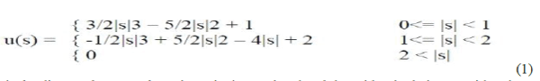 |
| Where s is the distance between the point to be interpolated and the grid point being considered. |
B.CS Based Image Resolution Enhancement
|
| This method adopts the CS methodology in the wavelet domain. The algorithm consists of two main steps as follows: |
| 1) An initial approximation to the unknown high resolution image is generated using wavelet domain zero padding (WZP). |
| 2) The cycle-spinning methodology is adopted to operate the following tasks: |
| a) A number of low resolution images are generated from the obtained estimated high resolution image in part (1) by spatial shifting, wavelet transforming, and discarding the high frequency subbands. |
| b) The WZP processing is applied to all those low resolution images yielding N high resolution images. |
| c) These intermediated high resolution images are realigned and averaged to give the final high resolution reconstructed image. Fig. 3 shows the block diagram of the WZP- and CS-based image super resolution. |
| PROPOSED METHOD |
| We have proposed a novel method to enhance the resolution of Satellite image using DWT and interpolation processes. |
A.DWT-based Resolution Enhancement:
|
| Resolution is important feature in satellite images. As increasing the resolution of these images will effects on performance of the system while using these images as input. The main loss of an image after being resolution enhanced by applying interpolation is on its high-frequency components, which is due to the smoothing caused by interpolation. Hence, in order to increase the quality of the enhanced image, preserving the edges is essential. DWT has been employed in order to preserve the high-frequency components of the image. The proposed DWT based satellite image resolution enhancement method is shown in Fig.4. |
| DWT separates the image into different sub band images, namely, LL, LH, HL, and HH. High-frequency sub bands contain the high frequency component of the image. The interpolation can be applied to these four subband images. In the wavelet domain, the low-resolution image is obtained by low-pass filtering of the high-resolution image. The lower solution image (LL subband), without quantization is used as the input for the proposed resolution enhancement process. In other words, low frequency subband images are the low resolution of the original image. |
| Therefore, instead of using low-frequency subband images, which contains less information than the original input image, we are using this input image through the interpolation process. The number of adjacent pixels to be interpolated is defined by interpolation factor α. Hence, the input low resolution image is interpolated with the half of the interpolation factor, α/2, used to interpolate the high-frequency subbands, In order to preserve more edge information, i.e., obtaining a sharper enhanced image, an intermediate stage in high frequency subband interpolation process is proposed. |
| The low-resolution input satellite image and the interpolated LL image with factor 2 are highly correlated. The difference between the LL subband image and the low-resolution input image are in their high-frequency components. Hence, this difference image can be used in the intermediate process to correct the estimated high-frequency components. This estimation is performed by interpolating the high-frequency subbands by factor 2 and then including the difference image (which is high-frequency components on low-resolution input image) into the estimated high-frequency images, followed by another interpolation with factor α/2 in order to reach the required size for IDWT process. The intermediate process of adding the difference image, containing high-frequency Components, generates significantly sharper and clearer final image. This sharpness is boosted by the fact that, the interpolation of isolated high-frequency components in HH, HL, and LH will preserve more high-frequency components than interpolating the low-resolution image directly. |
RESULTS AND DISCUSSIONS
|
| The proposed method has been tested on low resolution images of earth captured from artificial satellite namely Himalaya, coloba-mumbai, NE cost are shown in Fig.5. |
| The visual results of conventional and proposed methods are shown in Fig 6 and Fig 7 for comparison. Peak signal-to-noise ratio (PSNR in dB) and root mean square error (RMSE) have been implemented in order to obtain some quantitative results for comparison. PSNR and RMSE can be obtained by using the following equations (2)-(4). |
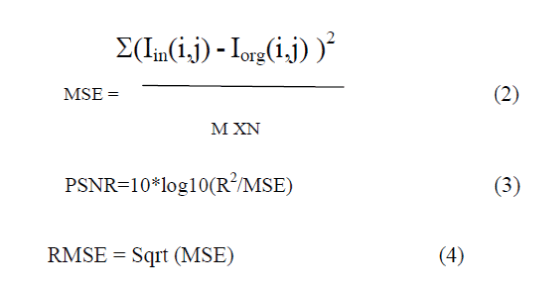 |
| Where R is the maximum fluctuation in the input image. MSE is representing the MSE between the given input image Iin and the original image Iorg, M and N are the size of the images. |
| The quantitative results of conventional method and proposed method are listed in Table 1 and Table 2. |
CONCLUSIONS
|
| This paper has proposed a novel method to improve the resolution of low resolution satellite images based on the interpolation of the high-frequency subband images obtained by DWT and the input low resolution image. The proposed method has been tested on earth images taken from satellite, where their PSNR and RMSE and visual results show the superiority of the proposed method over the conventional and state-of-art image resolution improvement techniques. The PSNR improvement of the proposed technique is up to 8 dB compared with the standard bicubic interpolation. |
Tables at a glance
|
 |
|
| Table 1 |
Table 2 |
|
| |
Figures at a glance
|
 |
 |
 |
 |
| Figure 1 |
Figure 2 |
Figure 3 |
Figure 4 |
 |
 |
 |
| Figure 5 |
Figure 6 |
Figure 7 |
|
| |
References
|
- H. Demirel and G. Anbarjafari, “Satellite image resolution enhancement using complex wavelet transform,” IEEE Geosci. Remote Sens. Lett.,vol. 7, no. 1, pp. 123–126, Jan. 2010.
- G. Anbarjafari and H. Demirel, “Image super resolution based on interpolation of wavelet domain high frequency subbands and the spatial domain input image,” ETRI J., vol. 32, no. 3, pp. 390–394,Jun. 2010.
- A. Temizel and T. Vlachos, “Wavelet domain image resolution enhancement using cycle-spinning,” Electron. Lett., vol. 41, no. 3, pp. 119–121,Feb. 3, 2005.
- Wavelet Filter Bank Series, “Matlab Tutorial”.
- K. Kinebuchi, D. D. Muresan, and T. W. Parks, “Image interpolation using wavelet based hidden Markov trees,” in Proc. IEEE ICASSP, 2001, vol. 3, pp. 7–11.
- M. S. Crouse, R. D. Nowak, and R. G. Baraniuk, “Wavelet-based statisti- cal signal processing using hidden Markov models,” IEEE Trans. Signal Process., vol. 46, no. 4, pp. 886–902, Apr. 1998.
|