Keywords
|
| Robotics, mechanism, actuator, navigation, motion etc. |
INTRODUCTION
|
| Environment mapping is considered an essential skill for a mobile robot in order to actually reach autonomy [1]. The robotic mapping can be defined as the process of acquiring a spatial model of the environment through sensory information. The environment map allows mobile robots to interact coherently with objects and people in this environment. The robot can safely navigate, identify surrounding objects and have flexibility to dealing with unexpected situations. Without a map some important operations could be complex as the determination of objects position in the surroundings of the robot and the definition of the motion to be followed. These issues involve the importance of the mapping task be performed correctly, since the acquisition of inaccurate maps can lead to errors in the inference of correct positioning of the robot, resulting in an imperfect implementation of these operations. Therefore there is a mutual dependence between inferring the exact localization of the robot and building an accurate map [2]. There are several researches done in robotics mapping proposing ways to represent a mapped environment, all of them concerned in dealing with high dimensional mapped environment. The metric representations store geometric properties of the environment, whereas the topological representations describe connectivity between different places. Within the metric representations, the occupancy grid stands out by providing a relatively accurate reproduction of the mapped environment. |
RESEARCH OBJECTIVES
|
| The important objective of the research is to provide a computer base solution to control robotics which is based on different sensors, software programs and hardware. We will inspect the robotic control in advance with the help of actuator and sensor which will help the mobile robot to navigate its different direction of the wall while avoiding different obstacle due to structure of building. This is achieved through developing a Robotics control model. |
LITERATURE SURVEY
|
| Robots are composed of movable physical structures, a power system (hydraulic, electrical or pneumatic), sensor system, a motor and a “brain” that tells its parts what to do. They may have an “arm,” called an end effect or that can use tools or be grippers. They will usually have a sensor which enables them to receive information about what is happening around them. This Thesis is contribute with the feature of robotic that is based on the control system .As how we can contribute the develop architecture and hierarchical representation of the command and manage a swarm mobile robot. This Model Contain topological and geometrical representation with the help of control system based on various control path planning, Electronic sensor, Digital components mechanics, Coordination, Actuation, Learning and adaptation. The topology of the space to be inspected is known in advance and the robot is able to navigate along different direction of the wall while avoiding the different obstacle due to structure of building. |
| As the research in robotics continues and has become more involved in the past decade, the need for an intelligent navigation system has been realized. Many students and researchers around the world have devoted great amounts of time in developing new ways for an artificial agent to navigate both locally and globally. It has become essential for an agent to be able to navigate unknown environments autonomously. Hence when we talk about navigation we imply three things, |
| • Mapping (the new environment) |
| • Path Finding |
| • Actuation |
| The problem of dynamic collision free path planning is vital to mobile robots and robots used in homeland applications. An attempt was made to create more versatile information systems by using adaptive distributed sensor networks [3]. Hundreds of small sensors, equipped with limited memory and multiple sensing capabilities which autonomously organize and reorganize themselves as ad hoc networks in response to task requirements and to triggers from the environment. A collection of active sensor networks can follow the movement of a source to be tracked, for example, a moving vehicle. It can guide the movement of an object on the ground, for example, a surveillance robot. Or it can focus attention over a specific area, for example, a fire in order to localize its source and track its spread. Path finding techniques can be grouped into local methods and global methods [4]. |
| The following assumptions are made about the robot and its environment: |
| 1. The robot is surrounded by an environment consisting of known pathways and pathway intersections. |
| 2. The robot may only travel along a defined set of pathways. |
| 3. The robot's origin and destination are both defined intersections of multiple pathways. |
| 4. The robot's movements are stochastic in that environmental variables, such as traffic and flooring surfaces, can alter the robot's actual location. |
| 5. The robot maintains a belief state about its location, but cannot ensure the validity of this belief state due to a limited array of sensors. |
| 6. Various aspects of the environment can be sensed and recognized as landmarks unique to a particular location |
| To represent the robot's known environment as a graph, each pathway is represented by a graph edge and each pathway intersection represented by a graph vertex. The robot's origin and destination must both be elements of the set of graph vertices. The path finding algorithm must return a sequence of vertices that are visited to reach the destination. The path finding algorithm is not designed to include real-time navigation, such as navigation around unexpected obstacles. As stated above, it is assumed that the robot's movements are stochastic. This is a result of environmental factors, such as variations in the friction between the robot's wheels and multiple flooring surfaces that can create discrepancies between the robot's belief state and its actual location. Additionally, factors such as the traffic of a pathway can impact both the efficiency and accuracy of the robot's movement, as a pathway with higher traffic can introduce additional environmental forces furthermore adjusting the robot's position while potentially slowing the robot's movement. |
| Robotics is an extremely dynamic field with thriving advancement in technology Along with other emerging technologies such as information technology, biotechnology, and nanotechnology robotics will contribute to increase opportunities for economic growth and greatly affect future generation with substantial social and economic impact [5]. Robots are composed of movable physical structures, a power system (hydraulic, electrical or pneumatic), sensor system, a motor and a “brain” that tells its parts what to do. They may have an “arm,” called an end effect or that can use tools or be grippers. They will usually have a sensor which enables them to receive information about what is happening around them. This Thesis is contributed with the feature of robotic that is based on the control system. As how we can contribute the develop architecture and hierarchical representation of the command and manage a swarm mobile robot using the autonomous control. An autonomous control robot is a robot that performs behaviors or tasks with a high degree of autonomy, which is particularly desirable in fields such as space exploration, cleaning floors, mowing lawns, and waste water treatment [6]. Autonomous robots are intelligent machines capable of performing tasks in the world by themselves, without explicit human control. This Model contain topological and geometrical representation with the help of control system based on various control motion planning, Electronic sensor, Digital components mechanics, Coordination, Actuation, Learning and adaptation. The topology of the space to be inspected is known in advance and the robot is able to navigate along different direction of the wall while avoiding the different obstacle due to structure of building. Making systems of various kinds perform well is what automatic control is all about. The interplay between robotics and control theory has a rich history extending back over half a century. |
| We begin this section of the report by briefly reviewing the history of this interplay, focusing on fundamentals, how control theory has enabled solutions to fundamental problems in robotics and how problems in robotics have motivated the development of new control theory. |
RELATED WORK
|
| Robotic control architecture the robot first plans a solution for the task by reasoning about the outcome of its actions and then executes it. Control process goes through a sequence of sensing, model update, and planning steps. Motion planning, sometimes called "Motion Planning", is the act of finding a motion to go from location A to B. A global motion planner usually generates a low-resolution high-level motion from A to B, avoiding large obstacles and dealing with navigation around the area. Local motion planning usually gives a high-resolution low-level motion only over a segment from global motion A to B, avoiding small obstacles and dealing with motion planning: angles of turn, appropriate velocities, etc. The planning module is also in charge of sending the goals of the problem that is being solved to the monitoring in order to supervise the execution of the proposed solution. In case of replanting, the planning module (that already knows the domain) will receive the high level state from the execution module. Then the entire process will begin again using this state as the new initial state, electronic sensor device which provides information about the physical world. Digital Computation which gives computationally any type of calculation that is the robotic motion detected analog or digital method. Mechanics is the part which gives the robot to move forward or backward in the location. Here we describe the nature of the robot how the robot co-ordinate with the obstacle with the help of actuator .Co-ordinate Level receives command to perform predetermined specific control task from the control manager to the above. It provides the appropriate sequence control and identification .The actuator which used in robotic to move the muscles of the robots with the help of Beep, Motors or LED Lights which given in below fig 1. |
| The Robotic Model which gives the study us for Robot Most of the papers on the control of rigid robots start with the well-known Large model and attempt to apply standard techniques to this model, be they in the nature of adaptive control, feedback linearization etc. This area is by now saturated, and there is not much left to be done in contrast. The problem of designing robot in such a way that they are easy to control has received relatively little attention one of the recent trends in robotics is the use of direct drive motors. “Direct drive” refers to the fact that the links of the robot are coupled directly to the respective motor shafts without going through any gearing. The advantage of such a scheme is that one immediately eliminates the effects of backlash, joint flexibility, etc. Which arise from the use of gears, and can therefore aspire to more accurate and repeatable performance from the robot? |
Nature of Navigation and Motion-planning problem
|
| In this section we define various terms that are used in mobile robot navigation and motion planning. We can define a robot as a programmable, multifunction manipulator designed to assigned tasks such as moving tools or specific devices through variable program motions to perform different tasks. The robot must exist in the physical world. The second point is the environment. Environment is the physical world surrounding the robot. Therefore the robots must have effectors with which it can interact with the environment. Intelligence may be interpreted in many ways. It may be considered as the ability to learn or comprehend or to tackling a new situation and efficient use of reasoning. It also deals with the application of knowledge to change the environment. It also includes grasping, learning, understanding, reasoning and thinking. Intelligence also deals with rationality. |
b. Architecture of Motion Planning
|
| Motion-planning is an important primitive for autonomous mobile robots that lets robots find the shortest motion or optimal motion between two points. Optimal motions could be motions that minimize the amount of turning. Algorithms to find a shortest motion are important not only in robotics, but also in network routing. |
| Robotic model is first based on the motion planning in which we have to plan his motion to navigate its different direction of the wall while avoiding different obstacles due to structure of building the robot. Motion-planning requires a map of the environment and the robot to be aware of its location with respect to the map. We will assume for now that the robot is able to localize itself is equipped with a map and capable of avoiding temporary obstacles on its way. Control process goes through a sequence of sensing, model update, and planning steps. Motion planning, sometimes called "Motion Planning", is the act of finding a motion to go from location A to B. A global motion planner usually generates a low-resolution high-level motion from A to B, avoiding large obstacles and dealing with navigation around the area. Local motion planning usually gives a high-resolution low-level motion only over a segment from global motion A to B, avoiding small obstacles and dealing with motion planning: angles of turn, appropriate velocities etc. The planning module is also in charge of sending the goals of the problem that is being solved to the monitoring in order to supervise the execution of the proposed solution. In case of replanting the planning module (that already knows the domain) will receive the high level state from the execution module. The hierarchical representation enables the mobile robot to travel from a user defined starting point A to a destination Point B through avoiding undefined obstacle on its route. A basic motion planning problem is to produce a continuous motion that connects a start configuration S and a goal configuration G, while avoiding collision with known obstacles. The robot and obstacle geometry is described in a 2D or 3D workspace, while the motion is represented as a motion in (possibly higherdimensional) configuration space. Accurate maps of the environment are essential for many mobile robot navigation tasks such as motion planning, surveillance, or coverage. Although real-world environments generally are dynamic, most existing mapping approaches assume the environment to be static. |
PROPOSED ALGORITHM
|
| Occupancy grids, as they were introduced by Moravec and Elfes (1985), are based upon a regular tessellation of the space into a number of rectangular cells. They store in each cell c of this grid the probability T(c) that the corresponding area in the environment is occupied by an obstacle. One particular assumption in the context of occupancy grids is that the environment is static. Accordingly, there is no explicit model about how the occupancy changes over time in this approach. The approach described in this paper overcomes this limitation. It applies HMMs (see Rabiner (1989)) to explicitly represent both the belief about the occupancy state and state transition probabilities of each grid cell. While occupancy grids regard the state of a cell as static, our representation explicitly models state changes, which makes it particularly suited for changing environments. Our method applies cell-specific hidden Markov models (HMM) to represent the belief about the occupancy state and state transition probabilities of each grid cell. The goal of an occupancy mapping algorithm is to estimate the posterior probability over maps given the data: |
| Occupancy Grid Cells Cij |
| • The proposition occ (i,j) means: – The cell Cij is occupied. |
| • Probability: T (occ (i, j)) has range [0,1]. |
| • Odds: o (occ (i, j)) has range [0, +∞). o(A) = P(A) / P(?A) |
| Log odds: log o (occ (i, j)) has range (−∞, +∞) |
| • Each cell Cij holds the value log o (occ (i, j)) – Cij = 0 corresponds to T (occ (i, j)) = 0.5 |
| As motions are randomly sampled, they will be most likely shakey and not optimal. Results can be drastically improved by running an additional algorithm that smoothes the motion. |
| a. Probabilistic Occupancy Grids |
| In these cases, the robotic system can consider such changes as inconsistent measurements taken at a given time. Think about the case where, in a given moment, a robot maps a table in your environment. Then, for some reason, this table is moved to another location at a later time, and this change of location, which should be changed also on a robot map, does not occur. With this, when the robot go through the place where the table was previously may seem that the robot is in a new location not yet mapped, because the object that should be detected, it is not. |
| We will apply Bayes Law |
 |
| Where A is occ(i,j) |
| And B is an observation r=D |
| We can simplify this by using the log odds representation. |
Easy Update Using Bayes Law
|
| The contribution of this work is a mapping approach for changing environments that represents the occupancy of the space and explicitly characterizes how this occupancy changes over time. We describe our model, how the representation can be updated as new observations become available, and how to predict future occupancy states. Furthermore, we present two techniques, one offline and one online, to estimate the state transition probabilities of the model from observed data. We evaluate our approach in simulation and using real-world data. The results demonstrate that our model yields highly accurate maps for changing environments. Furthermore, we describe how the explicit representation of the dynamics in the environment can be used to improve the motion planning performance of a robot. The update of the occupancy state of the cells follows a Bayesian approach. |
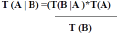
| • Bayes’ Law can be written: o (A |B) =?(B | A)*o(A) |
| • Take log odds to make multiplication into addition. Log o (A |B) =log ?(B | A) +log o (A) |
| • Easy update for cell contents. |
PSEUDO CODE
|
Occupancy Grid Cell Update
|
| • Cell Cij holds log o (occ (i, j)). |
| • Evidence r=D means sensor r returns D. |
| • For each cell Cij accumulate evidence from Each sensor reading. |
| Step1:Log o (A | B) = log ?(B |A) + log o(A) |
| Step2:Log o (occ (i, j)) + log? (r = D | occ (i, j))= log o (occ (i, j) | r = D) |
| Once a possible motion is found, this space can be reduced to the ellipsoid that bounds the maximal motion-length. This ellipsoid can be constructed by mounting a wire of the maximum motion length between start and goal and pushing it outward with a pen. All the area that can be reached with the pen constrained by the wire can contain a point that can possibly lead to a shorter motion. |
SIMULATION RESULTS
|
| In order to plan a motion, we somehow need to represent the environment in the computer. We differentiate between two complementary approaches discrete and continuous approximations. In a discrete approximation, a map is subdivided into chunks of equal (e.g., a grid or hexagonal map) or differing sizes (e.g., rooms in a building). Discrete maps are the dominant representation in robotics. A continuous approximation requires the definition of inner (obstacles) and outer boundaries, typically in the form of a polygon, whereas motions can be encoded as sequences of real numbers. |
| Currently the most common map is the occupancy grid map. In a grid map, the environment is discredited into squares of arbitrary resolution, e.g. 1cm x 1cm, on which obstacles are marked. In a probabilistic occupancy grid, grid cells can also be marked with the probability that they contain an obstacle. This is particularly important when the position of the robot that senses an obstacle is uncertain. The contribution of this work is a mapping approach for changing environments that represents the occupancy of the space and explicitly characterizes how this occupancy changes over time. |
| The model based on occupancy grid proposed is one of the most used metric approaches. The environment is represented as a regular grid of cells, where the value of each cell encodes its state that can be free, occupied, or not mapped (undefined). The occupancy value of a cell is determined using a probabilistic approach that has as input estimated distances to objects calculated from data given by the sensors. Through a Bayesian approach, it is possible to update the cell values at every time that a measure is performed. Note that a subset of the whole grid is updated each time. The resulting model can be used directly as a map of the environment in navigation tasks as path planning, obstacle avoidance, and pose estimation. Figure ilustrates the representation of a depth sensor measure in a 2D occupancy grid. Grey cells have unknown occupancy values, white cells are free and black cells are occupied. The main advantages of this method are: it is easy to construct and it can be as accurate as necessary. |
| All cells of the grid are initialized with gray color meaning that the occupancy value is not known at start. From the readings inside the field of view of the sonar, white cells (free) and black cells (occupied) can be determined. |
CONCLUSIONS
|
| In this paper we present a generalization of occupancy grids (Moravec and Elfes 1985), one of the most popular mapping approaches in mobile robotics. This Paper Presented the architecture of the Motion Planning robotic control and the reconfigurable autonomous control robotic system which suggesting navigating mobile robotic along different direction of the wall while avoiding different the obstacle due to structure of building. Various techniques have emerged to develop the science of robotics and robots robot that is “autonomous” does not need a person to operate it more importantly, it must also have the human ability to actually “learn” from its experiences and mistakes. This is an important goal for many designers. Motion planning is an ongoing research problem. Finding collision free motions for mechanisms with high degrees of freedom such as multiple arms operating in a common space, multi-robot systems, or systems involving dynamics (and therefore adding the derivatives of the state variables to the planning problem) might take unacceptably long to solve. We are currently working on the modules of autonomous control improving the control process to navigate the mobile robotics with its direction avoiding obstacle is also a part of our future work. Our medium terms goals including aspects of improving the control architecture and navigate along different direction of the wall while avoiding the different obstacle due to structure of building. |
Figures at a glance
|
 |
 |
 |
 |
| Figure 1 |
Figure 2 |
Figure 3 |
Figure 4 |
|
References
|
- S. Thrun (2002). Robotic mapping: A survey. In Lakemeyer, G. and Nebel, B., editors, Exploring Artificial Intelligence in the New Millenium.Morgan Kaufmann
- G. Grisetti, C. Stachniss, W. Burgard (2007) Improved Techniques for Grid Mappin With Rao-Blackwellized Particle Filter, IEEE Trans on Robotics, Vol. 23.
- ACM Transactions on Sensor Networks (TOSN) Volume 1 , Issue 1 (August 2005) table of contents Pages: 3 - 35 Year of Publication: 2005 ISSN:1550- 4859
- Robotics: State of the Art and Future challenges.
- En.wikipedia.org/wiki/Autonomous robot
- Mark W. Spong and Masayuki Fujita Control in Robotics.
|