Keywords
|
| GNSS, GPS, GSM, LBS, SAS |
INTRODUCTION
|
| Since every human activity is geo oriented, there is a requirement of incorporating this geographic aspect with information solutions. This can be done by integrating GNSS, Navigation, PNT, IT, GIS etc. This is a challenging task and can be achieved by using services like LBS, SAS can be provided easily. This new field will take human activity to that level which ICT has taken form the manual level. Hence world over research is being done in this sunrise sector[1].Today, Global Navigation Satellite Systems (GNSS) is more interesting in positioning techniques such as Global Positioning System (GPS). |
A. GLOBAL NAVIGATION SATELLITE SYSTEM (GNSS)
|
| Global Navigation Satellite System (GNSS) is playing a vital role in positioning and tracking techniques. The latest developments in GNSS have increased accuracy and other advantages of these systems. In near future there will be about 150 satellites providing more than 10 different services free of cost. The Indian subcontinent stands to gain as it will have more than 50 GNSS satellites visible at any time, the most possible coverage. Hence, this technology can be used gainfully in India. Indian governmental agencies have gone on an over drive to adopt this technology and the central government has pledged support for this technology in a major way. |
B. GNSS BASED MONITORING OF OPERATIONS
|
| Geographically locating, moving and monitoring of vehicle is an important activity in transportation. At present most of this work is done manually. GNSS present an easy way to locate vehicle over a geographic area accurately [1]. This location is mapped to accurate timing based on atomic clocks and hence will help in monitoring resources. GNSS finds application in Location Based Service (LBS) sector, Road Transport, Maritime Transport, Aviation, Agriculture, Disaster Management and Defense. |
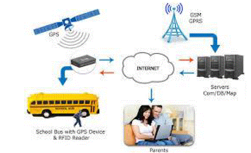
| Generally, the buses are consistently late by several reasons like heavy traffic, it become very impressive to develop a web application for monitoring bus in real time. Bus monitoring is using manual methods to monitor the position of bus like signals are manually operated by level crossing and staff on instructions by telephone from the nearest bus stop. The information about bus to public waiting on platform or home is dependent on manual process [2]. The current system only gives the position of a bus in between two stopping but can’t detect the real time position of the bus where it is right now. To overcome the above situation a GNSS based web application is developed which provide real time location of bus on Google Maps along with bus speed. Integration of GNSS and web technologies like Google Maps, web browser and internet offer a low cost bus monitoring solution, user’s computer require only a web browser. |
Overview
|
| Nowadays bus is very important mode of transport for the people to move from one place to other place. During the time of travel passengers face many problems such as arriving time of bus and travelling time [4]. The important objectives to be satisfied by the project are: |
| ? To send information about the location of buses to the parents via SMS. |
| ? To create a user friendly transportation system using GSM. |
| ? In order to reduce the waiting time of the parents. |
| GSM modem is used to transmit and receive information to the parents mobile. Mobile is used to get the information about bus.Global Positioning System is one of the widely used mobile standards. It enables the mobile users to interact all over the world at any time. GSM was actually designed to be platform independent [5]. GSM is a universal standard for cellular subscribers. The GSM is also provides a high-speeddata communication and Short Message Service (SMS) [10]. According to this paper the information about the location of the vehicle which is trapped is received by the GPS receiver then it is send to the user by using GSM technology [3]. |
| In the daily operation of a bus system, the movement of vehicles is affected by uncertain conditions such as traffic congestion and unexpected delays. Many passengers are often late to work, students are late for classes because they decide to wait for the bus [6]. Due to over waiting time and the uncertainty in bus arrival make an unpleasant for parents. |
| So the main objectives of this paper are: |
| 1. Developing Automatic vehicle location system using GPS for positioning information and GSM for information transmission. |
| 2. To send information about the location of vehicles (buses) to the parents by SMS. |
II. ARCHITECTURE
|
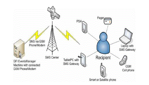
| Generally, there are two ways to send SMS from a computer to a mobile phone: |
| 1. Connect a GSM modem to a computer. By using AT commands the GSM modem can send SMS. |
| 2. Connect the computer to the SMS center (SMSC) to send SMS by using a protocol. |
| A GSM modem is a wireless modem similar to dial-up modem that works with GSM wireless networks. The major difference between wireless modem and dial up modem is way of transmitting the data. A wireless modem can transmit the data via a wireless network and a dial-up modem transmits data by using a copper telephone line. Generally, mobile phones can act as a wireless modem but they have certain limitations when compare to the GSM modem [9]. |
| To send SMS in this applications, first insert a SIM card in the GSM modem, which is connected to a computer. The computer can have the database to store the details of the passengers [5]. |
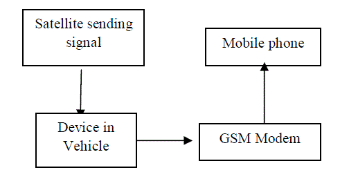
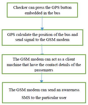
| When the checker or driver has pressed the GPS button which is embedded in the school bus, the GPS can calculate the position of the bus and time to reach the next stop. Before the bus reaching to their next stop, the GSM modem can send the information as SMS to the parents manually. |
| A GNSS based web application is developed which provide real time location of buses on Google Maps along with bus speed for monitoring buses.GNSS provide navigation and positioning information of a bus. |
| Steps following in this system |
| 1. The checker send the SMS to the GSM modem which is act as a client machine. |
| 2. The GSM modem having database that can store the details (contact number) of the passengers for a particular stop. |
| 3. It give attentiveness to the parents by passing the message before coming to their bus stop. |
| 4. The GSM modem is connected to a computer for communication over the mobile network. |
| 5. A GSM modem is act as interface in the applications to send and receive SMS. |
| Flow diagram of the system |
| The main advantage of this system is: |
| ? Useful for passengers waiting in the bus stand to know the bus position. |
| ? The data transformation will be effective since GSM is used as medium. |
| ? It may be implement to all types of vehicles and easy to install [7]. |
III. CONCLUSION
|
| School buses are generally reaching late to the stop due to heavy traffic so that the parents are waiting for a long time with their kids. By using this transportation system the parents can get correct time of the bus to reach the stop on their computers or mobile phones [8]. So it can reduce the waiting time of parents in the bus stop. In this system, the checker has to press the button manually and predict time to reach the next stop. But in future based on the location and speed of the bus automatically can calculate the time and send SMS to the passengers. |
Figures at a glance
|
 |
 |
 |
 |
| Figure 1 |
Figure 2 |
Figure 3 |
Figure 4 |
|
| |
References
|
- International Journal of Computer Applications (0975 – 8887) Volume 73– No.14, July 2013“GNSS Based Real Time Train Monitoring: AWebApproach”.
- Journal of Theoretical and Applied Information Technology 15th April 2012. Vol. 38 No.1 “public transport ticketing and monitoring system”.
- IRACST – Engineering Science and Technology: An International Journal (ESTIJ), ISSN: 2250-3498, Vol.2, No. 3, June 2012 “Real Time BusMonitoring System Using GPS “Dr. (Mrs.) SayleeGharge, ManalChhaya, Gaurav Chheda ,Jitesh Deshpande , NiketGajraDepartment of Electronics and telecommunication, V.E.S. Institute of Technology, Mumbai University, India.
- Tactful management research journal vol. 1 , issue. 12 ,sept 2013 “a model of gps based vehicle information system: a new invention for vehiclecontrol in india”.
- International Journal of Scientific and Research Publications, Volume 3, Issue 5, May 2013, “Implementation of Real Time Bus MonitoringandPassenger Information System” Mrs.SwatiChandurkar, SnehaMugade, Sanjana Sinha, MegharaniMisal, PoojaBorekar,Computer Department, MAEER’S MIT AOE, Alandi (D) University of Pune 411015,Maharastra,India.
- Ganesh K and Thrivikraman M, Net Logic Semiconductors Pvt. Ltd., Banglore “Implementation of a real time passenger information system”.
- Lin, W.-H. and J. Zeng. “Experimental Study on Real-Time Bus Arrival Time Prediction with GPS Data”. In Transportation Research Record: Journalof the Tranportation Research Board,No. 1666, TRB, National Research Council, Washington, D.C., 1999, pp1019.
- International Journal of Communications and Engineering Volume 01– No.1, Issue: 01 March2012 “GPS AND GSM BASED VEHICLE INFORMATIONSYSTEM “.
- Umar Farooq, TanveerulHaq, Senior Member IEEE, Muhammad Amar, Muhammad UsmanAsad, Asim Iqbal.” GPS-GSM Integration forEnhancingPublic Transportation ManagementServices “.© IEEE 2010.
- Md. FoisalMahediHasan, GolamTangim, Md. Kafiul Islam, Md. RezwanulHaqueKhandokar, ArifUl. “RFID-based Ticketing forPublic Transport System: Perspective MegacityDhakaAlam”©IEEE 2010.
|