Keywords
|
| Urban Heat, Chennai, Surface Temperature, Gaussian Surface, Climate change. |
INTRODUCTION
|
| Climate change is a significant and lasting change in the statistical distribution of weather patterns over periods ranging from decades to millions of years. It may be a change in average weather conditions, or in the distribution of weather around the average conditions. Climate change is caused by factors that include oceanic processes such as oceanic circulation, biotic processes, variations in solar radiation received by Earth, plate tectonics and volcanic eruptions, and human-induced alterations of the natural world; these latter effects are currently causing global warming, and "climate change" is often used to describe human-specific impacts. More recent data are provided by the instrumental record. Physically based general circulation models are often used in theoretical approaches to match past climate data, make future projections, and link causes and effects in climate change and increase in temperature. |
| The most common form of anthropogenic climate change is urban heating. Any change or alteration in the urban areas will cause the local air and the surface temperature to increase greatly. This cause an increase in the temperature to several degrees than the surrounding areas. In the past few years many studies have been made regarding this phenomenon in various parts of the world like Spain, Iceland etc. This change or increase in temperature of a particular area is an effect which is often known as Urban Heat Island (UHI). |
| Urban Heat Island studies are done in two ways as one is measuring the air temperature using some automobile transects or weather station networks. These type of study gives data that have a high temporal resolution that is the data with respect to time and it also provide us with a long data record as the sensors or the measuring instrument will reside on the same place of experiment for longer period of time. This data will not provide spatial resolution. The other way of studying the UHI is through airborne or satellite remote sensing. This method measures the surface (or skin) temperature. The data obtained from this type of measurement will have very high spatial resolution the resolution of smaller object will be more clearly visible in these types of data. But it provides less temporal resolution that is data with respect to time. These types of data will provide only shorter record as the satellite or the measuring instrument will be moving all the time and cannot provide clear temporal resolution. Majority of climatology studies of UHI are done using remotely sensed data. The purpose of this paper is to study and measure the growth or surface temperature UHI of Chennai, India for the past ten years. |
II. AREA OF STUDY
|
| Chennai, sometimes referred to as the "Gateway to South India,"[1][2] is located on the south–eastern coast of India in the north–eastern part of Tamil Nadu on a flat coastal plain known as the Eastern Coastal Plains. Its average elevation is around 6.7meters (ft) [3] and its highest point is 60 m ( ft).[4]Latitude : 11° 00' N. Longitude : 78° 00'E Chennai [5][6] unofficially known by its former name, Madras is the capital city of the Indian state of Tamil Nadu. Located on the Coromandel Coast off the Bay of Bengal, it is a major commercial, cultural, economic and educational center in South India. It is also known as the "Cultural Capital of South India"[7] and was declared as the most livable city in India by the Institute of Competitiveness [8][9][10] on account of economic, social, security and medical conditions as parameters. According to the provisional results of 2011 census, the city had 4.68 million residents making it the sixth most populous city in India; the urban agglomeration, which comprises the city and its suburbs, was home to approximately 8.9 million, making it the fourth most populous metropolitan area in the country and 31st largest urban area in the world. This urbanization paved us the interest to find the increase in temperature in the past few years in this area. |
III. DATA SOURCE
|
| The temperature growth is determined from the surface temperature maps of the Chennai, TamilNadu region. The data are obtained from the numerous scenes obtained using the airborne satellite. The images taken over two discrete intervals need to be used for this measurement. Approximately intervals of two year. The cloud free images can be taken as it has less error correction. If the images contain cloud the cloud can absorb heat and that will also be reflected. This clouds parameter will alter the temperature measurement. Hence cloud free images are taken for the experiment. The monthly distributions of images are needed for better results. All the images taken for the experiments are taken during the descending pass of the satellite. And all the images at a particular time in the later afternoon are taken as it has the reflection and refraction in a moderate quality. Images with zenith angle less than 20 degree is only considered as the images taken with angle greater than 20 degree will be taken from a lengthened atmospheric path of the satellite and may produce higher degree of uncertainties. |
IV. PROPOSED METHODOLOGY
|
| Much of the energy from the Sun arrives on Earth in the form of infrared radiation. Sunlight at zenith provides an irradiance of just over 1 kilowatt per square meter at sea level. Of this energy, 527 watts is infrared radiation, 445 watts is visible light, and 32 watts is ultraviolet radiation.[11] The balance between absorbed and emitted infrared |
| Radiation has a critical effect on the Earth's climate. Based on this infrared radiation the temperature needs to be measured. Most of the satellite have multichannel of image acquit ion process. Each satellite its own process of acquiring the images. The fig 2 shows a brief flow of the entire process of measuring the temperature of the Chennai city. |
| A. Radiance Value Calculation |
| Each satellite has different split window channels. The split-window method corrects for atmospheric effects based on the differential absorption in adjacent infrared bands [12]-[16]. Radiance values of the channels used need to be calculated. This calculation is done using calibration coefficient. This calibration coefficient may be accurate or some time needs correction |
| B. Radiance Correction |
| The calibration coefficient obtained for each channel is not accurate. This needs to be corrected to get the accurate temperature measurement. The formula (1) is used to find the radiance correlation coefficient between the various channels used in the experiment. This will correct linearity of the channels and will produce the corrected radiance value Ri |
 |
| C. Plank’s Equation of Radiation |
| The corrected radiance values (Ri) are then converted into the brightness temperature. The Plank function is used to compute the radiance emitted from objects that radiate like a perfect “Black Body”. Planck's law describes the electromagnetic radiation emitted by a black body in thermal equilibrium at a definite temperature. A black body is an idealized physical body that absorbs all incident electromagnetic radiation, regardless of frequency or angle of incidence. We observe a certain radiance coming from an object. We invert the Planck Function to find its temperature from the radiance. A temperature found in this way is called the “brightness temperature”. The Plank?s equation of radiance is given as Ri. |
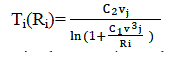 |
| Where the C1 and C2 are the constants in the equation. The values of these constants are C1 = 1.1910659×10⁻⁵m Wm-2 sr-1 cm4 and the value of the constant C2=1,438833 cm K, and vj depends on the channel it is the central wave number of each channel. |
| D. Surface Temperature |
| Land surface temperature is how hot the “surface” of the Earth would feel to the touch in a particular location. From a satellite?s point of view, the “surface” is whatever it sees when it looks through the atmosphere to the ground. It could be snow and ice, the grass on a lawn, the roof of a building, or the leaves in the canopy of a forest. Thus, land surface temperature is not the same as the air temperature that is included in the daily weather report. The brightness temperature data from the split window channels obtained using Plank?s equation is then used to calculate the surface temperature. The surface temperature is calculated using the technique of Price [19]. |
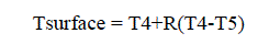 |
| Where T4 and T5 are the brightness temperature of channel 4 and 5. The channel selection is purely based on the satellite. Different satellite works with different channels to image the land. Channel 4 and channel 5 are the channels that work well for the IR images. For the purpose of measuring the temperature these IR images are only suitable hence in most cases these imaging channels are only used. In equation 3 the R= 1/(β5/β4-1)]= 3.33 the value 3.33 is the constant value that deals with the atmospheric absorption coefficients for the channel 4 and 5. These surface temperature maps helps in calculating the individual UHI measurements. This is done to the method used in measuring the temperature of a particular image [17] [20]. |
| E. Gaussian surface temperature measurement |
| The method of Gaussian surface temperature is used to measure the growth of the temperature for the continuous couple of years. This is done by using least square fit of the entire island to a Gaussian surface. The square is fit to a surface of the form |
 |
| This method provides us with not only a measure of the UHI magnitude representative of the entire city (ao), but also gives us the spatial extent (ax and ay), orientation (Ø), and central location (xo and yo) of the heat island as well. This method is also used to determine the spatial gradients (a1 and a2) and mean value (To) of the surface temperature of the surrounding rural area. |
| 1) Preprocessing before Fit: |
| The above values orientation spatial extent and all are obtained by performing the fit to the images. The fit is done by fitting the rural image to the planar surface. For this we need just the rural pixels in the image and not the whole image which consists of clouds water body and the urban pixels. For getting the rural pixels alone a land temperature image is created by masking out all areas of clouds and open water. The region of the land temperature image that contains the urban area is then temporarily masked out, producing an image consisting entirely of rural pixels in which we are working with. As the exact spatial extent of the UHI is unknown prior to measurement, the urban mask must be large enough that it completely covers the urban pixels. It is unavoidable that some of the urban area is also masked out as well. The urban mask does not change from image to image, resulting in all cloud free rural images having the same number of rural pixels. |
| 2) Performing Fit: |
| The rural pixel image is obtained after preprocessing by removing the unwanted pixels. This rural temperature image is fit to a planar surface, resulting in the determination of To, a1, and a2. The rural temperature components (the first three terms on the right-hand side of Eq. (3)) are then subtracted from the land temperature image; this is done to find out the temperature gradient leaving only the heat island signature. The temperature image of the UHI is then fit to a pure Gaussian surface (the exponential term on the right-hand side of Eq. (3)), which determines the UHI measurements. The UHI magnitude is the height of the Gaussian (ao), and the longitudinal and latitudinal extents of the UHI are the Gaussian width parameters (ax and ay). The orientation (/) and central location (xo and yo) of the UHI are also found out. This latitudinal and longitudinal extend gives us the exact growth of the temperature for the give set of image data. |
V. CONCLUSION
|
| UHI magnitude depends on environmental variables such as wind speed, cloud cover, and atmospheric aerosol and water vapour content. The UHI spatial extent likely also depends on many spatial variables, such as surface moisture and vegetation cover. UHI should be viewed as a dynamic meteorological phenomenon and not as a constant, uniform feature. The Population density of Chennai is 26903, which is currently largest in the state of Tamil Nadu. Chennai has witnessed a tremendous growth in its manufacturing, retail, health care and IT sector in the last 10 years. Because of this the spatial extent of the city for the give set of data will definitely show the growth rate. Change or alteration in the urban areas will cause the local air and the surface temperature to increase greatly. This causes an increase in temperature of several degrees than the surrounding areas. Hence this methodology helps us to determine the increase in the temperature growth if the Chennai city for the give set of period. |
Figures at a glance
|
 |
 |
| Figure 1 |
Figure 2 |
|
| |
References
|
- Chennai activities”, (http:/ / www. nasscom. org/ chennai-activities), NASSCOM, Retrieved 2012-12-28.
- Chandramouli; and Rajesh; ”Chennai emerging as India's Silicon Valley?”, (http:/ / economictimes. indiatimes. com/ Infotech/Software/Chennai_emerging_as_Indias_Silicon_Valley/ articleshow/ 3000410. cms), The Economic Times, Retrieved 2012-12-28, May 2008.
- Chris Devonshire-Ellis, “Doing Business in India”, (http:/ / books. google. co. in/ books?id=aIx9E5I9LB8C& pg=PA218& lpg=PA218&dq="detroit+ of+ India"& source=bl& ots=vGpyGlNKoJ& sig=GSsUbokkCn_L_pmWqC9f0CU7cK4& hl=en& sa=X&ei=IM5OUKi IYnJrQfcoYHgBQ& ved=0CD0Q6AEwAw#v=onepage& q="detroit of India"& f=false), Springer. p. 218, ISBN 9783642276170,.Retrieved 2012-12-28.
- “Competitive Conditions for Foreign Direct Investment in India”, Staff Research Study #30 (http:/ / books. google. co. in/books?id=hMIo-FZXCYEC& pg=SA2-PA10& lpg=SA2-PA10& dq="detroit+ of+ India"& source=bl& ots=zzQgYonnem&sig=XN_vU0VThij2mka78NH5Ae2Nruc& hl=en& sa=X& ei=YNxOUOL1F4vqrQfpzIGoDw&ved=0CC8Q6AEwAA#v=onepage&q="detroit of India"& f=false), U.S. International Trade Commission, DIANE Publishing, ISBN 9781457818295, pp. 2–10,Retrieved2012-12-28, 2007.
- Dictionary Reference: Chennai (http:/ / dictionary. reference. com/ browse/ Chennai)
- The Free Dictionary: Chennai (http:/ / www. thefreedictionary. com/ Chennai)
- Rina Kamath; Chennai (http:/ / books. google. co. in/ books?id=bw2vDg2fTrMC& pg=PA66& lpg=PA66& dq=chennai+ cultural+capital& source=bl& ots=sDz-Lx6Zes& sig=d454fbF34q2iWKjKLHSLRoBTfUE& hl=en& sa=X& ei=mGtOUKWGGq6yiQe5ooCwBA& ved=0CC8Q6AEwAA#v=onepage& q=chennai cultural capital& f=false), Orient Blackswan, ISBN 9788125013785, p.66, Retrieved 2012-12-28, 2000.
- http:/ / competitiveness. in/ 2012/ 12/ 26/ liveability-index-2012/
- http:/ / competitiveness. in/ wp-content/ uploads/ 2012/ 01/ Liveability-Index-2012. Pdf
- http:/ / www. reuters. com/ article/ 2012/ 12/ 26/ idUSnPreLpJjda+ 128+ PRN20121226
- “Reference Solar Spectral Irradiance: Air Mass 1.5” (http:/ / rredc. nrel. gov/ solar/ spectra/ am1. 5/ ), Retrieved 2009-11-12.
- J. C. Price; “Land surface temperature measurements from the split window channels of the NOAA-7 AVHRR”, J. Geophys. Res., vol. 79, pp. 5039-5044, 1984.
- F. Becker, “The impact of spectral emissivity on the measurement of land surface temperature from a satellite”, Int. J. Remote Sensing, vol. 8, no. 10, pp. 1509-1522, 1987.
- Z. Wan; and J. Dozier; “Land-surface temperature measurement from space: physical principles and inverse modelling”, IEEE Trans. Geosci. Remote Sensing, vol. 27, no. 3, pp. 268-278, 1989.
- F. Becker; and Z.-L. Li; “Toward a local split window method over land surface”, Int. J. Remote Sensing, vol. 3, pp. 369-393, 1990.
- J. A. Sobrino; C. Coll; and V. Caselles; “Atmospheric corrections for land surface temperature using AVHRR channel 4 and 5”, Remote Sensing Environ., vol. 38, no. 1, pp. 19-34, 1991.
- David R. Streutker*; “Satellite-measured growth of the urban heat island of Houston”, Texas.
- Department of Physics and Astronomy, Rice University, Houston, TX 77005, USA.
- fig1:https://www.google.co.in/search?hl=en&q=chennai+district+map&tbm=isch&tbs=simg
:CAQSWRpXCxCo1NgEGgIICgw
LELCMpwgaMAouCAESCPgFywaGB6YHGiClWhyI3O
BahtClx4pveyloyFSxYwo1dZWrMIfWt8USSAwLEI6u_1ggaCgoI
CAESBLYR684M&sa=X&ei=lNB4UeeiEoL_rAf7YHoCA&ved=0CCgQwg4&biw=1280&bih=881
- Price, J. C; “Land surface temperature measurements from the split window channels of the NOAA 7 Advanced Very High Resolution Radiometer”, Journal of Geophysical Research, 89, 7231–7237, 1984.
- Streutker, D. R; “A remote sensing study of the urban heat island of Houston, Texas”, International Journal of Remote Sensing, 23, 2595– 2608, 2002.
|