Keywords
|
| Wireless networks, Vehicular ad-hoc networks, location-based routing protocol, geographic routing. |
INTRODUCTION
|
| A wireless ad hoc network is a decentralized type of wireless network. The network is ad-hoc because it does not rely on a pre-existing infrastructure, such as routers in wired networks or access points in managed (infrastructure) wireless networks. Instead, each node participates in routing by forwarding data for other nodes, so the determination of which nodes forward data is made dynamically on the basis of network connectivity. In addition to the classic routing, ad hoc networks can use flooding for forwarding the data. |
| The next generation of wireless communication systems, there will be a need for the rapid deployment of independent mobile users. Significant examples include establishing survivable, efficient, dynamic communication for emergency/rescue operations, disaster relief efforts, and military networks. Vehicular Ad-hoc Networks (VANETs) can be considered as a subset of Mobile Ad hoc Networks (MANETs) with unique characteristics. A typical VANET consists of vehicles and access points along the road. Vehicles move on the roads sharing information between themselves and with the Internet through the access points. Vehicles often move at high speed but their mobility is rather regular and Predictable. High speed movement creates scenarios characterized by a very dynamic network topology. Vehicles can always rely on recharging batteries. An accurate estimate of vehicles position can be made available through GPS systems or on-board sensors. VANETs are used for short range, high-speed communication among nearby vehicles, and between vehicles and roadside infrastructure units. |
| In VANET, or Intelligent Vehicular Ad-Hoc Networking, defines an intelligent way of using Vehicular Networking. In VANET integrates on multiple ad-hoc networking technologies such as Wi-Fi IEEE 802.11p, WAVE IEEE 1609, WiMAX IEEE 802.16, Bluetooth, IRA, ZigBee for easy, accurate, effective and simple communication between vehicles on dynamic mobility. Effective measures such as media communication between vehicles can be enabled as well as methods to track the automotive vehicles. In VANET helps in defining safety measures in vehicles, streaming communication between vehicles, infotainment and telematics. |
RELATED WORK
|
| [1] A Routing Strategy for Vehicular Ad Hoc Networks in City Environments Routing of data in a vehicular ad hoc network is a challenging task due to the high dynamics of such a network. Recently, it was shown for the case of highway traffic that position-based routing approaches can very well deal with the high mobility of network nodes. However, baseline position-based routing has difficulties to handle two-dimensional scenarios with obstacles (buildings) and voids as it is the case for city scenarios. In this paper it analyse a position-based routing approach that makes use of the navigational systems of vehicle. While DSR's performance is limited due to problems with scalability and handling mobility, both AODV and the position-based approach show good performances with the position-based approach outperforming AODV. |
| [2] Rapid generation of Realistic Mobility model for VANETs is one emerging, new type of ad-hoc network is the vehicular ad-hoc network (VANET), in which vehicles constitute the mobile nodes in the network. Due to the prohibitive cost of deploying and implementing such a system in real world, most research in VANET relies on simulations for evaluation. A key component for VANET simulations is a realistic vehicular mobility model that ensures conclusions drawn from simulation experiments will carry through to real deployments. In this work, a new tool MOVE is introduced that allows users to rapidly generate realistic mobility models for VANET simulations. MOVE is built on top of an open source micro-traffic simulator SUMO. The output of MOVE is a realistic mobility model and can be immediately used by popular network simulators such as ns-2 and qual-net. |
| [3] Survey of routing protocols in vehicular ad hoc networks deals with a survey of routing protocols in vehicular ad hoc networks. The routing protocols fall into two major categories of topology-based and position-based routing. [4] discusses the advantages and disadvantages of these routing protocols, explores the motivation behind their design and trace the evolution of these routing protocols. Finally, it concludes the chapter by pointing out some open issues and possible direction of future research related to VANET routing. |
| [5] An Evaluation of Inter-Vehicle Ad Hoc Networks Based on Realistic Vehicular ad hoc networks (VANETs) using WLAN technology have recently received considerable attention. The evaluation of VANET routing protocols often involves simulators since management and operation of a large number of real vehicular nodes is expensive. The performance of AODV and GPSR is significantly influenced by the choice of mobility model, and it observe a significantly reduced packet delivery ratio when employing the realistic traffic simulator to control mobility of nodes. |
PROPOSED ALGORITHM
|
| A. HLAR Protocol: |
| A hybrid location-based ad hoc routing (HLAR) protocol, which was particularly designed with optimal scalability performance. It combines a modified AODV protocol with a greedy-forwarding geographic routing protocol. HLAR have features of reactive routing with location-based geographic routing. Our proposed protocol is to efficiently make use of all the location information available, to minimize the routing overhead, and to gracefully exit to reactive routing as the location information degrades. In proposed system each node will have the following two separate tables, which were locally constructed from the beacon packets: |
| 1) a neighbour table, which will be used to perform geographic routing, |
| 2) an “ETX” table, which will be used to construct the AODV route (the AODV routing table) upon request to obtain optimal scalability performance. |
| B. HLAR Architecture: |
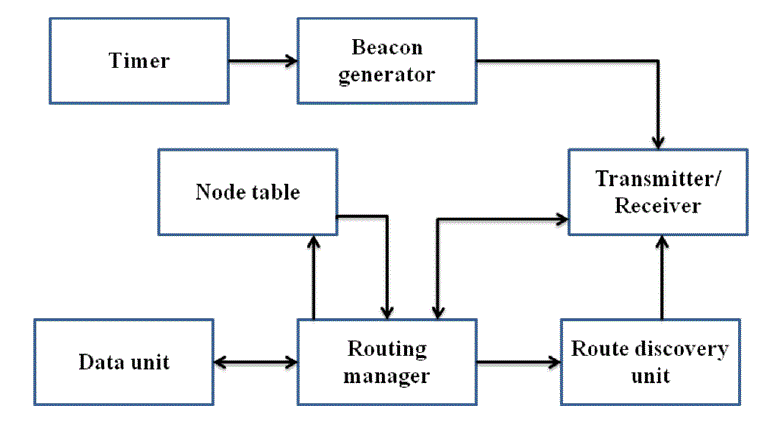
| In the above Figure 3.1 the timer is a specialized type of clock for measuring time intervals. Each nodes transmits data packets which are generated in a particular time interval. The timer is set for a certain time period so that the periodic update of the vehicle or node’s location parameters are done. Beacon generator is one of the management frames in IEEE. After receiving the beacon frame all the stations change their local clocks to this time. This helps with synchronization. This is the time interval between beacon transmissions. The time at which a node (AP or station when in Ad-hoc) must send a beacon is known as Target Beacon Transmission Time (TBTT). Beacon interval expressed in Time Unit (TU). It is a configurable parameter in the AP and typically configured as 100 TU. Capability information field spans to 16 bits and contain information about capability of the device/network. Type of network such as Ad-Hoc or Infrastructure network is signalled in this field. Apart from this information, it announce the support for polling, encryption details also. |
| An Omni direction antenna is used both for transmitting and receiving. Since the mobility of the nodes is in all directions and the transmission of the data packets will be in all direction. Since the main characteristics of Omni directional antenna is that the transmission and reception does not have any particular angle so it is used. The transmission range used is 150-250 meters. The node table have the information about the neighboring vehicles such as, |
| 1. Neighbor vehicle ID |
| 2. Current location of the vehicle |
| 3. Destination vehicle ID |
| The data unit have the data that is to be transmitted from the source vehicle or node to the destination vehicle or node. The data packets that are transmitted from the transmitter reaches the routing manager and it does the operation of comparing the node table and the data packet transmitted. It compares and gives the information to the Route discovery unit. |
| C. Modules: |
| (a) Creating Neighbor Vehicle Information: |
| Vehicles need to locally broadcast small beacon packets periodically. These periodic beacon packets include the vehicle’s ID and the current location coordinates. These beacon packets also allow vehicles to build their neighbor information table. |
| (b) Route Discovery: |
| If the source vehicle has no route to the destination vehicle, then source vehicle initiates the route discovery in an on-demand fashion. After generating RREQ, node looks up its own neighbor table to find if it has any closer neighbor vehicle toward the destination vehicle. If a closer neighbor vehicle is available, the RREQ packet is forwarded to that vehicle. If no closer neighbor vehicle is present, then the RREQ packet is flooded to all neighbor vehicles. A destination vehicle replies to a received RREQ packet with a route reply (RREP) packet in only the following three cases: |
| ? If the RREQ packet is the first to be received from this source vehicle. |
| ? If the RREQ packet contains a higher source sequence number than the RREQ packet previously responded to by the destination vehicle. |
| ? If the RREQ packet contains the same source sequence number as the RREQ packet previously responded to by the destination vehicle, but the new packet indicates that a better quality route is available |
| (c) Local Repair |
| Vehicle mobility will cause the communication links between vehicles to frequently be broken. A local repair will, in general, also cost less power consumption relative to re establishing a new source-todestination route. Intermediate vehicles that participate in exchanging data traffic are allowed to locally repair broken routes through a route repair (RRP) packet instead of just reporting a broken route to its source vehicle. |
SIMULATION RESULTS
|
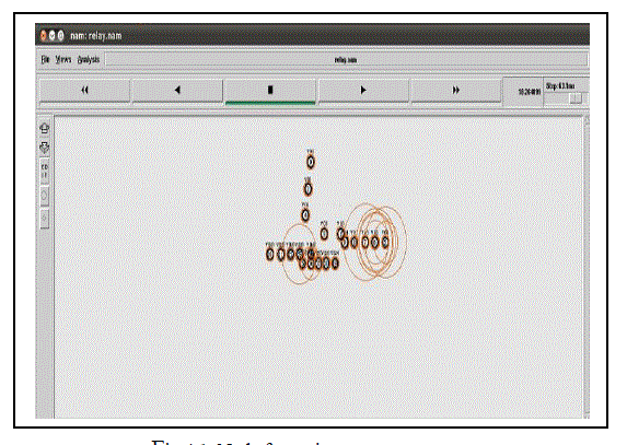
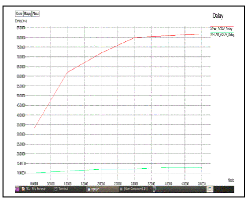
| The simulation studies involve the deterministic small network topology with 20 nodes as shown in Figure4.1. The proposed HLAR protocol is implemented with Network Simulator-2. The data of same size of data packets is transmitted within this 20 nodes and the performance analysis is done for different parameters and the comparison is done among the existing AODV protocol and the HLAR protocol. End-to-end delay refers to the time taken for a packet to be transmitted across a network from source to destination. Figure 4.2 shows the end to end delay comparison between the normal AODV and HLAR protocol. For the 2nd node the delay is 12 ms in HLAR protocol whereas in AODV it is 73ms. |
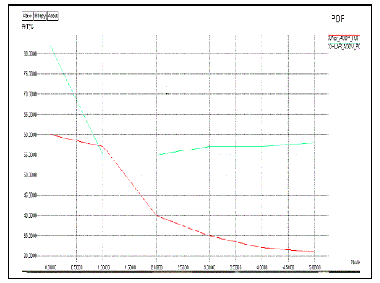
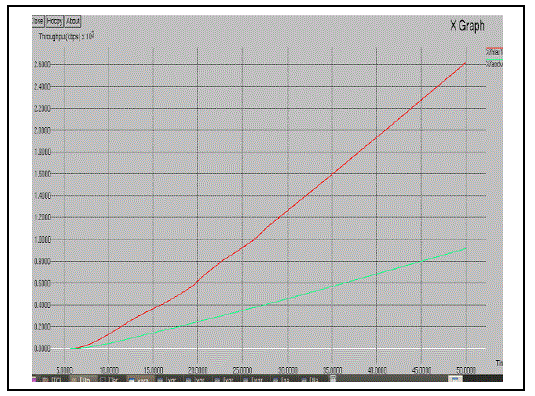
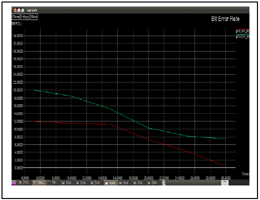
| Figure 4.3 shows the packet delivery ratio of HLAR and normal AODV protocol. In AODV protocol as the number of nodes increases the number of packets generated gets lost at the time of transmission. The data loss also occurs in the HLAR protocol but when compared with the AODV protocol the data loss is less. During the time of transmission as the number of nodes increases in AODV protocol nearly 30% of the packets are lost whereas in HLAR protocol 20% of the packets are lost. Figure 4.4 shows the throughput comparison between HLAR and normal AODV protocol. In HLAR protocol the number of packets delivered is more 1.7 kbps more than the normal AODV protocol. At time 25ms the packets delivered is 0.38 kbps for AODV and in HLAR it is 0.98 kbps. The bit error rate or bit error ratio (BER) is the number of bit errors divided by the total number of transferred bits during a studied time interval. BER is a unit less performance measure, often expressed as a percentage. |
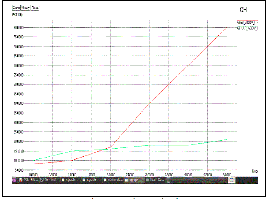
| Generally in VANETs, nodes often change their location within network. So, some stale routes are generated in the routing table which leads to unnecessary routing overhead. Figure 4.6 shows the routing overhead is more in normal AODV protocol and in HLAR protocol it is comparatively low. The HLAR protocol have 20 kb when there are 5 nodes whereas the normal AODV have 73 kb. This comparison is done among 5 nodes. |
CONCLUSION AND FUTURE WORK
|
| To conclude, a new hybrid location-based ad hoc routing protocol, HLAR, which combines features of reactive routing with location-based geographic routing, through simulations that a significant reduction in the routing overhead can be achieved in HLAR compared to standard reactive and geographic routing protocols. A demonstration is made how such a performance improvement leads to a scalable routing solution in the context of VANET environments. Finally the main conclusions hold, even in the presence of location errors. HLAR is simple to deploy and yet effectively obtains optimal scalability performance, making it an ideal candidate for the routing protocol in emerging VANETs. The simulated result shows the bit error rate and throughput and shown better performance when compared with AODV protocol. The multi-source multicast and geo-cast routing are worth to develop since the multimedia services are welcome today. |
Figures at a glance
|
 |
 |
 |
 |
| Figure 1 |
Figure 2 |
Figure 3 |
Figure 4 |
|
 |
 |
 |
| Figure 5 |
Figure 6 |
Figure 7 |
|
References
|
- R. La and E. Seo, “Expected routing overhead for location service in MANETs under flat geographic routing,” IEEE Trans. Mobile Comput.,vol. 10, no. 3, pp. 434–448, Mar. 2011.
- Al-Rabayah and R. Malaney, “Scalable hybrid location-based routing in vehicular ad hoc networks,” in Proc. IEEE Veh. Technol. Conf., Fall 2011, pp. 1–5.
- M. Al-Rabayah and R. Malaney, “A high-capacity scalable routing protocol for VoIP in wireless ad hoc networks,” in Proc. IEEE WCNC, Sydney, Australia, 2010, pp. 1–6.
- Saleet, O. Basir, R. Langar, and R. Boutaba, “Region-based location service-management protocol for VANETs,” IEEE Trans. Veh.Technol.,vol. 59, no. 2, pp. 917–931, Feb. 2010.
- R. A. Malaney, “Nuisance parameters and location accuracy in log-normal fading models,” IEEE Trans. Wireless Commun., vol. 6, no. 3, pp. 937–947, Mar. 2007.
|