International Journal of Innovative Research in Computer and Communication Engineering
ISSN ONLINE(2320-9801) PRINT (2320-9798)
ISSN ONLINE(2320-9801) PRINT (2320-9798)
Shweta Shandilya1, S.R.Idate2
|
| Related article at Pubmed, Scholar Google |
Visit for more related articles at International Journal of Innovative Research in Computer and Communication Engineering
GPS (geo-graphical positioning system) technology is used for navigation and positioning of the user. It helps users to navigate through maps but this concept faces problem when there are obstructions due to buildings and is almost useless for navigating in an indoor environment. Many other techniques involve the use of external sensors and RFID’s that can be installed or can be carried around along with the user. But all this techniques involve devices which are either not cost effective or creates problem in case of device failure. . By using the concept of WI-FI triangulation method for the purpose of localization of a user inside a building like mall, campus, hospital etc. this problem can be overcome. WIFI are nowadays already installed, for example in a shopping mall there are various outlets and all these consist of WIFI inside them. By developing a system that uses these WIFI routers for localization of user and guiding them through the premises by downloading a map from server via a shortest path. Users can save location, browse offers and events of various outlets through a smartphone.
KEYWORDS |
| Smartphone, WI-FI, Navigation and Indoor localization. |
I. INTRODUCTION |
| Whenever a user visits a new site (place) which has a large perimeter a proper guidance system is needed. When the user is outdoors technology like GPS can easily be utilize but when inside a premises like a hospital, college, mall etc., it doesn’t work so it is very difficult for the user to navigate through the place and reach their destination. Various technologies have been used over time for the purpose of navigation like RFID, sensors, Bluetooth, WIFI etc.; while on one hand technologies like RFIDs and external sensors need to be carried around by the user all the time. There is also the issue of cost effectiveness in such devices and on the other hand devices like Bluetooth which is already available in smartphones cannot be used because of their short range. |
| So the most efficient way for navigation is through a WIFI in such conditions. This system works on the same principle where WIFI technology is being utilized to help user to navigate in an indoor environment. Here already available WIFI in the user’s smartphone and those inside the different outlets (in case of shopping malls) or departments (in case of college and hospital) are used for the purpose of navigation and tracking on site. Here already made available map (by administrator) are downloaded from the server to user’s smartphone. Then this map is plotted with various locations of outlets and then this map is saved to the users’ mobile unit. WIFI routers are used to localize (to find the exact position of the user) user through a concept called triangulation method (it requires signals from three or more Wi-Fi routers). |
| Signal strength is an important factor for finding the exact an accurate location of smartphone user because if the strength is weak of even one of the routers then the position would be wrong by some meters. Though it is not a big issue in outdoor environment it is problematic in indoor environment as the user will be standing outside an outlet and the application will show another one. This is highly inefficient and the application won’t be of much use. So we need three routers with good signal strength. |
| Navigation requires maps which are already plotted and stored by the administrator in the database. These maps can be used to locate various outlets and turn by turn navigate through the building to the required user destination. Shortest path is calculated and displayed for user to choose from. While navigating user can access the information about any offers and deals from various shops. If the user wants he can save the location like the location of parking spot to exactly return to it easily. The user can even view calendar for upcoming events organized in the premises. User can also find their friends if they have the same application in their system and track them easily if they are inside the premises. |
II. RELATED WORK |
| IAlexeyKashevnik [1], Based on technology smartphone is used where all the features like its design, architecture and properties can be carried out. Technology like Wi-Fi, GSM and Bluetooth are inbuilt in the phone. Here comparative analysis of all the various techniques is done. The main concept is to provide user the functionality through which it can position as well as locate them. Here they provide solution for indoor positioning and navigation. By using algorithms like fingerprinting and triangulation they locate the user; maps are created for floor plans to position the user. As using Wi-Fi fingerprinting technology it will give accurate position of the users. It also provides information on special offers for outlets and contextual information to the user. |
| Amir Nakib [2] refers to indoor location which is static, as for outdoor system GPS is used which works accurately while designing mobile terminals for location tracking GPS is introduced but for obstructed area like inside the building where GPS signal are not found this system will not work and find the path. Now to overcome this different prediction method is used such as linear prediction, kalman prediction and particle prediction. It enhances the mobile phone user accuracy by predicting the trajectory using Digital fractional integration. To improve the performance we use the prediction methods like kalman filter and other existing linear filters. |
| According to Takamasa Higuchi [3] for indoor positioning it is a big challenge for mobile user to provide exact position to the user. As in indoor, sometimes there is accuracy problem in positioning the user due to mobility errors. “Stop and go” behavior of the pedestrian is evaluated here using cooperative localization. The concept behind this is that to find the movement of the nodes i.e. static or moving. Now static nodes are used to reduce the battery power, the tracking should be done accurately and with energy efficiency. Cooperative localization is a method which is used to ensure the distance between the nodes for evaluating the location of the user. |
| Lyu-Han Chen [4] concerns with indoor positioning system where the pedestrian dead reckoning PDR system is used which is based on mobile sensors. As mobile sensors are gyroscopes, magnetometer, digital compass and accelerometer. For indoor tracking these sensors are used to locate and estimate the user movement. In this WIFI system makes use of pedestrian dead reckoning system because the disadvantage of WIFI is overcome using PDR system. Using algorithms and methods like intelligent fusion algorithm the user location and its orientation should be determined. Nowadays Smartphones are equipped with a rich set of sensors i.e. inertial sensors. For indoor positioning system this sensors are important to recognize the real time user movement. For accuracy and stability of positing recognition the algorithm called fusion algorithm is used. |
| Li Geng [5] addresses the indoor tracking using RFID i.e. radio frequency identification system as this system is previously used which is very cost effective here tag ID is used in premises and through the detection of tag Id, the location of user is recognized. |
| Nicholas D. Lane [6] focuses on Smartphones changes the life style of people, anywhere in location around us people become interactive with mobile device. Mobile phones and smartphones are the center of attraction and people used this phone as their part, Therefore in this paper we conclude the survey of smartphone sensing. Many applications using smartphone for e.g. in corporate world, hospitals, transportation, security etc. in today’s world of technology people don’t have time therefore the mobile device is used for interaction. Smartphones are highly equipped with sensors like GPS, accelerometer, digital compass, microphone, Wi-Fi etc. thus mobile phone sensing is rapidly increasing. Already we know that all people carry mobile phone through which they interact with applications, games, social networking sites and other resources they use to download files and data in mobile phone only. Through smartphones all these actions are possible. We can view the map, also localization and navigation is done through GPS system. |
| In this growing age of technology many features and applications are deployed which provide location based services. Many sensors like Wi-Fi, GPS accelerometer gyroscopes, orientation sensors and digital compass is used. For outdoor location tracking GPS geo positioning system is used and still it is very limited in some areas due to the signal strength. GPS is not used for indoors therefore for indoor tracking other application and methods are used i.e. Bluetooth, WI-FI, RFID and other proprietary systems. |
| Lei Zhang [7] Sens-Track it’s a service for location tracking where sensors are used. GPS is used when user is outside the building and WIFI is used for indoor environment. Here android smartphone is used which is equipped with sensors to collect the data from the user. This reduces the use of GPS and increase accuracy. As smartphone faces the problem in battery consumption due to its low battery life processing and other features affect. Here solution for battery consumption is implemented. Using GPS user cannot be tracked under indoor environment therefore location sensing techniques is used to obtain the exact position. Using various sensors at a time makes the system accurate and it increases the energy efficiency cost. |
III. PROPOSED WORK |
| Starting of the localization includes the triangulation method through which user location is tracked and user navigates turn by turn to the destination. |
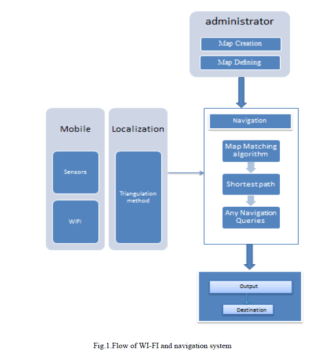 |
| Steps for developing WI-FI Navigation system are as follows:- |
| Step 1: In the first step the user needs to find all the Wi-Fi signals within the range of smartphone. This can be accomplished by scanning functionality of the system which provides a list of all the available sensors as its output. |
| Step 2: Administrator of the system builds the map for site and makes it available for the user to download it from the server. |
| Step 3: By employing the triangulation method using the Wi-Fi the system finds the current location of the user. |
| Step 4: When the user needs to go to a certain destination on the site, they have to specify the destination and automatically the system plots the path from the current location to the destination and gives back the best possible path back as feedback to the user. |
| Step 5: User can easily save the position for future use and navigate back to that position later. |
| Step 6: The user can access all the events and offers provided onsite. |
| Step 7: The user can also communicate with the other users of the same system and can easily locate them. |
| Various functionalities are used to develop and integrate the application. These functionalities are:- |
| A. Admin android application: |
| • Site creation |
| • Site definition |
| B. User android application: |
| • Site download |
| • Site download |
| • Wi-Fi tracking |
| • Navigation |
| • Offers and events |
| • Track friends |
| 1. Site creation: This functionality is used by the administrator of the system who is responsible for creation and uploading of maps if they are not already available. In site creation admin creates a custom canvas to render user image map. Also it creates a tracking site which consists of plotting of all points and connecting them with the most efficient and shortest path available. |
| 2. Site definition: here the administrator defines the various functionalities such as specifying the north of the map; define the rooms in the map and the path between these locations, the scale for image to map (i.e. mapping meters against pixels) and the plotted image or map is uploaded to the server so that it can be easily downloaded by user. Site download: This functionality is provided to the user when he requires visiting a site or place (example mall, hospital etc.).It allows user to download selected site details subsequently creating canvas to load the require image on it. |
| 3. Sensor calibration: It helps the user to perform the function of tracking using sensor. |
| 4. Wi-Fi tracking: It allows the user to use Wi-Fi for the purpose of finding all the Wi-Fi signals and reading them. It also allows the user to find the current location and this location is plotted on the canvas. |
| 5. Navigation: whenever the user wants to navigate the site user defines the current and destination locations and accordingly user is provided with a path according to his needs. The system fulfils this request by first plotting the path and then providing the user the best possible path to his destination. |
| 6.Offers and events: The user can easily get the information about any sales and upcoming events onsite and accordingly participate and utilize them. |
| 7. Track friends: this is a utility of the system which allows the user to find and track any other people who use the same application in their handsets and ultimately contacting and communicating with them. |
IV. APPLICATION |
| • Indoor navigation in premises such as mall, museum, hospitals etc. |
| • Tracking the various outlets or departments according to user’s choice. |
| • Easily allows for the creation and mapping on the site plans. |
| • Offers the best possible path automatically for user’s convenience. |
V. CONCLUSION AND FUTURE WORK |
| A Wi-Fi based technology is being used in the system here to provide a user with the facility of indoor navigation using a smartphone. First of all the maps of the floor plans which are already present on the server at the premises are downloaded by users. These maps or floor plans are further plotted and stored by the system we are using. These helps the user in efficiently using there smartphones to navigate through the structure very easily. As this application also provides the feature of saving the location helps users in finding back the place very easily and accurately once it is saved. For example a person can easily return back to the parking space where they parked there vehicle without any difficulty. This application uses triangulation method which requires the signal strength from at least three Wi-Fi routes in the building strong enough to pin point the exact location of the user’s position and also of those outlets that user wants to visit. User can also find out about any current and upcoming events held in the campus by looking at the calendar provided in the application. Furthermore using the contact list this application enables the user to find if any of their contacts are present in the same area that they are in if the other users have the same application installed in their respective handsets. |
References |
|