International Journal of Advanced Research in Electrical, Electronics and Instrumentation Engineering
ISSN ONLINE(2278-8875) PRINT (2320-3765)
ISSN ONLINE(2278-8875) PRINT (2320-3765)
| Srikanth K P, Kamali C, Abhay Pashilkar FMCD, CSIR-National Aerospace Laboratories, Bangalore, India |
| Related article at Pubmed, Scholar Google |
Visit for more related articles at International Journal of Advanced Research in Electrical, Electronics and Instrumentation Engineering
An important component of Synthetic Vision System is the terrain database. As the pilot relies on the terrain database, the integrity of database has to be monitored continuously. The integrity monitor checks for consistency between sensed terrain profile from DGPS and radar altimeter data and the terrain profile provided by static elevation data. This paper discusses integrity check of the information derived from terrain databases using DGPS and radar altimeter. Kalman filtering is used to bias errors in vertical domain.
Keywords |
| Synthetic Vision Systems, Terrain Database Integrity Monitoring, Kalman Filter |
INTRODUCTION |
| Studies have found that majority of flight accidents occur due to Controlled Flight Into Terrain (CFIT) [1]. Accidents where pilot flies the aircraft into terrain or unseen obstacles while he is in complete control of the aircraft is termed as CFIT. Inability of the pilot to monitor the surrounding environment due to poor visibility conditions is one the main reasons. This can be due to inclement weather like fog, rain or during night. In such scenarios, the pilot must rely on the instruments and other navigation aids for flight operations. The situational awareness (SA) provided by these instruments can be enhanced by Synthetic Vision Systems. A “Synthetic Vision System” is an aircraft cockpit display technology that presents visual environment external to the aircraft using computer-generated imagery in a manner analogous to how it would appear to the pilot if forward visibility were not restricted. |
MOTIVATION |
| Synthetic Vision Systems (SVS) provide a clear, daylight view of the outside environment during all phases of flight, even in poor visibility conditions [2]. The basic idea of SVS displays is to provide synthetic computer-generated moving images to the pilot which is an accurate depiction of the outside world. SVS uses static terrain databases to generate the outside view to the pilot. The terrain information is available as Digital Terrain Elevation Data (DTED) sets released by Aster, Shuttle Radar Topography Mission (SRTM), National Remote Sensing Centre (NRSC), India etc. Each elevation data has its own defined area of coverage and error characteristics. |
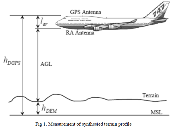
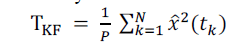
| Display of hazardous misleading information must be avoided if the terrain elevation databases are to be utilized for flight-critical applications. The block schematic of sensed elevation measurement is shown in Fig 1. Data from Differential Global Positioning System (DGPS) and radar altimeter is used to generate synthesised elevation profile. |
| Terrain database integrity refers to the capability to detect errors in the terrain database that could cause or contribute to the failure of a system function [1]. A database integrity check is required to reduce the probability of such undetected database errors being displayed to the pilot. The integrity monitor checks the consistency between the sensed terrain profile as computed from GPS and radar altimeter data and the terrain elevation profile as given by the DTED. Probability of agreement between these two profiles is computed and used to monitor the DTED integrity. Warnings are provided to the pilot when an error is detected that results in the display of hazardous misleading terrain information (HMTI) on the SVS display. An SV System consists of various components such as SVS display, SVS computer, terrain elevation database to generate the terrain, obstacle database, navigation systems etc. An undetected failure in each one of these components can lead to a failure of the overall SVS [3]. |
A. Previous Work |
| Much work has been done on terrain database integrity monitoring using both downward looking and forward looking sensors. Forward looking sensors like LiDAR, X-band weather radars have been used along with GPS inputs to implement terrain feature detection algorithms to monitor DEM integrity [2]. This paper discusses the implementation of a downward looking integrity monitoring using Radar Altimeter and DGPS. |
| SV systems can be used as Advisory, Strategic or tactical applications depending on the risk of operation due to probability of an undetected failure [3]. The integrity levels required for these three types of applications are determined by their probability of an undetected failure. This is greater than 10-5, between 10-5 and 10-9 and smaller than 10-9 respectively for the above three systems respectively. |
| In the absence of visual cues due to bad weather, a pilot primarily relies on the aircraft's external sensors for situational awareness. Differential GPS, Inertial Reference System (IRS) and AHRS provide spatial position and orientation information. GPS receivers are typically capable of providing position information with reference to various coordinate frames such as ECEF coordinate frame and the WGS 84 reference frame. The height information could be with respect to the WGS84 reference ellipsoid. Radar altimeter measures the height of aircraft above ground level (AGL). |
 |
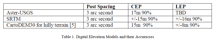
B. Digital Elevation Models |
| Elevation databases used to generate external view to the pilot are known as digital elevation models (DEMs). DEMs are defined based on post-spacing, horizontal and vertical datums and circular and linear errors. The horizontal accuracy on the post spacing is represented by circular error whereas vertical accuracy is defined by vertical error. An overview of DEMs with their accuracies available for Indian sub-continent as listed in Table 1. The horizontal datum is WGS84 and vertical datum is mean-sea level. The segment size of DTED is 1 deg x 1 deg. |
 |
| The digital elevation database can by either DTED 0 or DTED 1. As this method uses DGPS and radar altimeter inputs, failure of any one of these will result in failure of integrity monitoring capability. The concept of this system is depicted in Fig 1. |
| Ideally, a DEM must represent the height of terrain at corresponding horizontal coordinates. Due to systematic faults and randomly distributed errors introduced during formulation of database, elevations deviate from the true value. The terrain database errors can be in the form of biases, ramps in vertical and horizontal domains and randomly distributed errors in vertical domain and circularly distributed random errors in horizontal domain [4]. Bias errors in vertical domain are studied in this paper. Biases in a DEM larger than a nominal level are considered DEM failures. As DEMs have inbuilt sensor measurement noise and random errors, it is difficult to detect these errors in absolute sense, but only in the statistical manner. |
| Absolute and successive disparities are used to express the degree of agreement between the synthesised and database terrain [2]. The absolute disparity concept is explained in the next section. Terrain Integrity monitoring can be carried out in Spatial, Horizontal and Vertical domains. Vertical integrity monitoring is studied in this paper. DTED integrity monitor algorithm’s performance is verified based on data collected from flight test of a fighter aircraft. |
TERRAIN DATABASE INTEGRITY MONITORING IN VERTICAL DOMAIN |
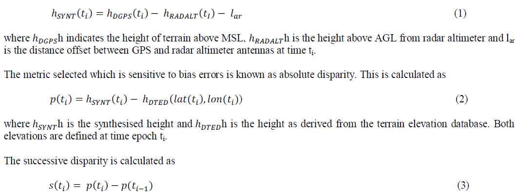
| This concept proposed in [1], compares the terrain elevation data with terrain data synthesized using a downwardlooking sensor. Radar Altimeter and DGPS sensors are used for this purpose. Radar altimeter measures Height Above Ground Level (AGL). DGPS sensor measures the height of aircraft above Mean Sea Level (MSL). Failure of one or both of these sensors means the integrity monitoring has failed. Ideally the difference between these sensor measurements must be equal to height of terrain above the mean sea level. |
| The synthesied height is calculated as |
 |
| Although successive disparity removes radar altimeter biases, but can miss bias-like errors in the elevation database which is undesirable. For the integrity monitoring, absolute disparity is used to derive test statistics. Since the absolute disparities (AD) are normally distributed, their squares are chi-squared. The sum-of-squares of N consecutive absolute disparities are used as test statistic in the hypothesis testing. Test statistics indicate agreement based on systems’ nominal performance. An integrity alarm is raised when the test statistic exceeds a pre-defined threshold. The meansquared difference (MSD) is used to calculate the test statistics. |
| The absolute disparity is defined as |
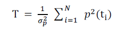 |
| where T represent the Test statistic, 2 indicates the variance and p indicates the disparity value wrt time ti. |
| The summations are over N absolute or (N-1) successive disparities and N is interpreted as integration time. For the case study presented here, degrees of freedom N is chosen as 50 consecutive measurements. For these error values, the statistic threshold is found to be 96 [2]. For DTED level 1, studies have shown that absolute disparities are distributed according to N(0,(18.9)2) and successive disparities are distributed according to N(0,(13.0)2) for DTED level 1. For a type I error, the fault free detection error is chosen as 10-4. |
A. Test Statistic Using Kalman Filtering |
| The use of sensors for measurement of a physical quantity never yields its exact value. There always exists an error, some deviation from the actual value. If the measurement deviates from the actual value by a constant amount, then there is a bias present. Errors whose magnitudes do not exhibit a regular trend, i.e. which are random but seem to be clustered together are called noise. This noise is considered in this study. This study investigates the use of Kalman filter [4] for terrain database check monitoring. |
| As explained earlier, the T-statistic is a ratio of the sample variance to the population variance, scaled by the number of samples. When the filter is run for the absolute disparities, the statistical variance of the estimates, given by the P matrix in the Kalman recursion, would be variance of the complete population of filtered estimates over the terrain database area. P matrix is only a theoretical value computed by the filter and represents the true value for correctly modeled linear systems. The T-value using the filtered estimates can be computed as follows: |
 |
| Where values are the Kalman filter estimates of the sample disparities and P is their steady state variance. |
VERTICAL TERRAIN DATABASE INTEGRITY MONITOR RESULTS |
| From flight tests conducted on a fighter aircraft, the aircraft position in terms of latitude, longitude, its attitude, DGPS altitude, radar altitude and other data were collected for a few flights. For the area of flight, SRTM elevation data has been considered. The integrity check algorithms are implemented using Matlab. |
| As explained in section 3.0, the results of integrity monitoring of absolute disparity with and without using Kalman filter is presented below. |
| Fig 3 shows the computed values of the T statistic using DGPS measurements of aircraft position and radar altimeter height for a particular aircraft during an approach to runway. The data segment considered has minimum pitch and roll which does not contribute much to the T statistic value. |
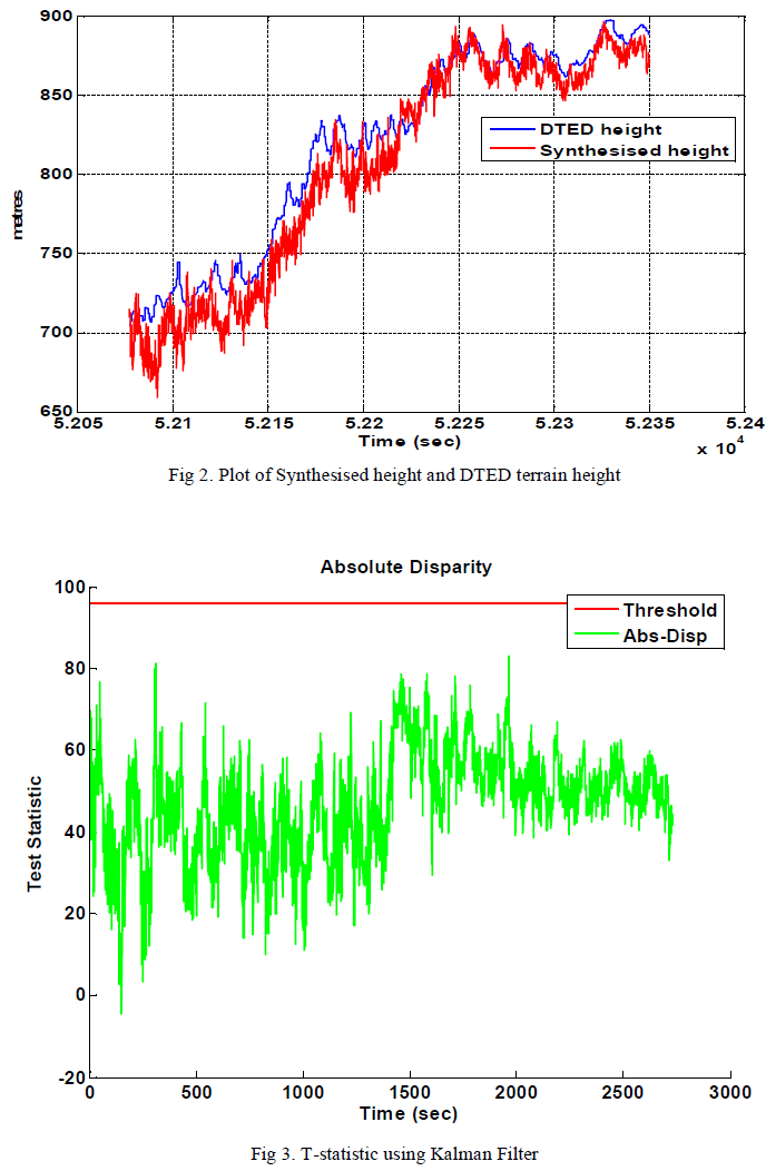 |
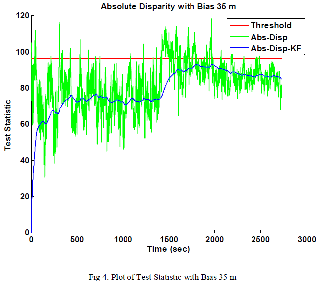
| The plots of Fig 3 shows bias present in absolute disparity is reduced when passed through a Kalman filter. Fig 4 shows that even with a bias of 35 m, some points cross the threshold but are filtered out so that no false alarm is raised due to presence of bias upto 35m. |
 |
CONCLUSION |
| Terrain database integrity monitors are necessary for an SVS system as this guarantees the reliability of the system. In this report, vertical domain integrity monitoring for terrain databases for a downward looking sensor is explained. Real data of a high performance aircraft has been used to validate the algorithms. Due to presence of noise on the sensors and terrain databases that affect the performance of the integrity monitor, Kalman filtering technique is implemented. From the plots is it seen that using a Kalman filter improves the noise filtering and thus reducing false alarms to the pilot. |
References |
|