Keywords
|
| Shape file, Geoserver, digital assistant ( mobile ,pda) , .NET, wireless technology. |
INTRODUCTION
|
| M-GIS is the expansion of GIS technology from the office into the field. A mobile GIS enables field-based personnel to capture, store, update, manipulate, analyze, and display geographic information directly in the field. The spectacular growth of the use of digital Geo information in parallel with the advances in Information Technology (IT), collecting in-situ data have been dramatically improved using handheld devices. Due to recent developments in files of internet and Mobile GIS technology, spatial data collection, processing and dissemination of large amount of spatial data are easily possible. Attributes, which describe qualities associated with features, are stored in tables. Data attribute type and field properties, such as precision, scale, or length, must be specified when creating fields for the attribute table of a new shapefile or when adding a new field to the attribute table for an existing shapefile. The choice of attribute data type and associated settings affect storage and display and can have serious consequences for the accuracy and efficiency of the underlying database.Attribute data in shapefiles are in the dBase (.dbf) file, and all you need to do is t o edit that file and add more data fields. There is a one-to-one correspondence between the rows in this table and the shape records in the .Shp file. A typical attribute field that you may find in a dBase table is a field that identifies the name of the corresponding shape. |
BASIC ASPECT OF SHAPEFILE
|
| The ESRI Shape file or simply a shape file is a popular geospatial vector data format for geographic information systems software. A "shape file" commonly refers to a collection of files with ".shp", ".shx", ".dbf"[2]. |
| A.The Shape file Format |
| ESRI (Environmental Systems Research Institute) is a leading developer of GIS software and the Shape file format used by their products is one of the most popular mediums for storing vector map data. An ESRI shape file is actually composed of three separate files: a main file with a .SHP extension, an index file with a .SHX extension, and a dBase file with a .DBF extension that contains the associated attribute data. The main file (with a .SHP extension) is the primary component and its structure begins with a fixed-length, 100-byte header containing information about the total length of the file, the file version, and the type of shapes it contains. This file header is then followed by a list of variable-length records, with each record defining the geometry for a single ESRI shape[3]. An ESRI shape might be a polygon that represents the political boundary of a country, a polyline that represents the path of a city street, or a point object that indicates the location of a city. The figure below illustrates the format of a .SHP file The other supporting file which are required are to collect information about File number, File version, File code, File length and Shape type. The application run on the user mobile phone and change or add the required data to a database server on the wireless toolkit.The dBase file associated with a shape file contains the attribute data and essentially represents a single database table. |
| The three files must have the same base name and follow 8.3 naming conventions as shown in the figure below A Web Map Service (WMS) is a standard protocol for serving geo referenced map images over the Internet that are generated by a map server using data from a GIS database WMS specifies a number of different request types, two of which are required by any WMS server: |
| ? Get Capabilities - returns parameters about the WMS and the available layers |
| ? Get Map - with parameters provided, returns a map image. |
| In ArcGIS, you can store a value for a feature attribute as one of seven data types—short integer, long integer, float, double, text, date, and binary large object |
| (BLOB). Attribute tables also contain predefined fields that hold data on geometry and the object ID. Float and double data types contain real numeric values and are used for continuous data that is measured or calculated[4]. Short and long integer data types store data that represents numeric values that can be counted or that designate a coded value used for classification. Temporal aspects of a feature, such as when a valve was last tested, are stored as a date type. GIS applications are software applications that process large amounts of geospatial data, involving heavy computations. |
CLIENT COMPONENTS
|
| Technological advances in the field of mobile computerized devices have resulted in a large variety of such products entering the markets during the past decade (Graham et al. 2003). This is very advantageous to M-GIS applications since it brings about a high degree of diversity to the range of devices that would allow for M-GIS applications to be run on. These devices are also allowing for an increasing degree of interoperability between the devices and communication infrastructures[5]. Mobile cellular phones (“cell phones”) must surely be the most popular mobile device in the market today, however not all cell phones are compatible with all promised features of M-GIS applications (Informa Telecoms Group 2002a). The five main classifications are discussed below In 1999 Sun Microsystems announced a redefined architecture for the Java platform, aimed to make it simpler for software developers, service providers and device manufacturers to decide what aspects of technology they need (Alexander 2001). The revised structure consists of three editions of the Java platform. |
METHODOLOGY
|
| Detailed planning |
| ? Creation of Geo Database |
| ArcGIS is built around the geo database, which uses an object-relational database approach for storing spatial data. A geo database is a "container" for holding datasets, tying together the spatial features with attributes. The geo database can also contain topology information, and can model behavior of features, such as road intersections, with rules on how features relate to one another. When working with geo databases, it is important to understand about feature classes which are a set of features, represented with points, lines, or polygons[6]. With shape files, each file can only handle one type of feature. A geo database can store multiple feature classes or type of features within one file. |
| The integrated geographic database of MNNIT campus has been created in GIS and consists of spatial database and non spatial database. These two databases have been linked together by common identifiers. The spatial database consists of various thematic maps consisting of point, line and polygon features. The point features have control points. The line features have the road network classes and the polygon features have the buildings, ground and parks. Thematic layers that are required to be incorporated in the MNNIT GIS were identified for the creation of spatial database of MNNIT Campus. |
| The approach is defined by the above flowchart in section. This flowchart indicates the process of work been carried out. Basis for the work comprises of the literature review which is done to develop a methodology[8]. This literature review helps to find out the objectives of the work and further far. The Web Feature Service defines interface for describing data manipulation operations of geographic features. Data Manipulation operations include the ability to |
| ? Query feature based on spatial and non spatial constraints. |
| ? Create a new feature instance |
| ? Delete a new feature instance. |
| ? Update a new feature instance |
INTEGRATING GEOSPATIAL AND MOBILE GIS
|
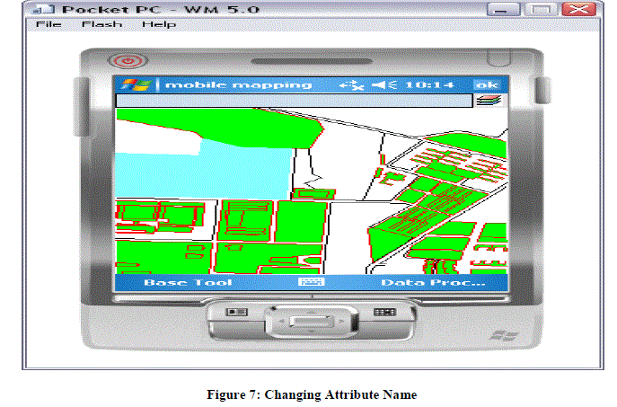
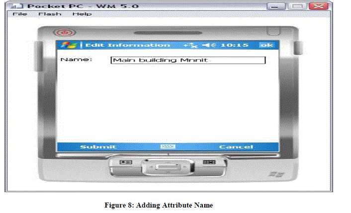
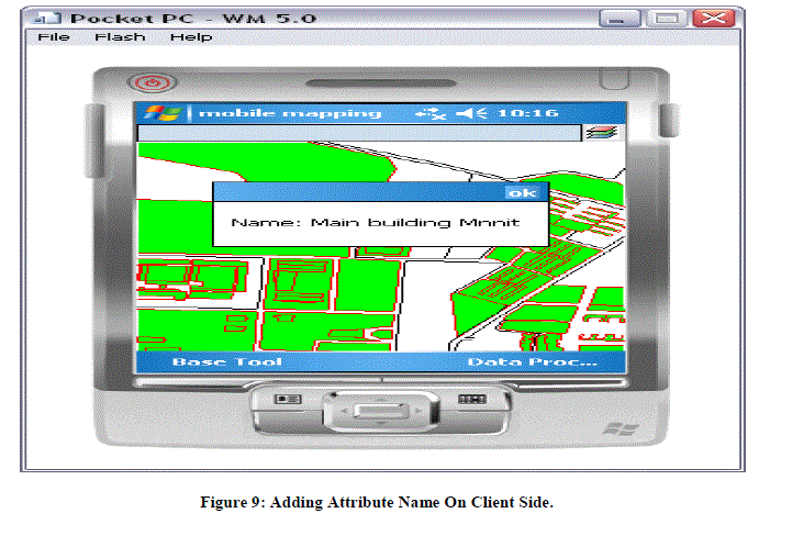
| The mobile web services are designed and geospatial database are created. If we already have imported shape files in the distributed environment then we have to work only on the IIS server where we store the geospatial information. We work on IIS server as a database for fetching the geospatial information. The IIS server deploys and defines all the functionalities of M-GIS such as changing attribute name, adding attribute and adding layers in hand-held device or in a distributed environment on the client side innovation. |
| Spatial data have been created in the form of shape files. Each individual layer of the map has initially converted to shape files. When a layer is converted to shape file, the three numbers of flat files are generated with extensions .dbf, .shx and .shp, each feature id and name have been added to the layer itself, apart from the automatically generated default shape-id, for easy linking across spatial and non-spatial data [9]. |
| Once the WAP Gateway receives WAP requests from the client, it translates the requests to HTTP requests, and then sends them to the Web Server. Once the WAP Gateway receives HTTP responses (web contents) from the Web Server, it translates the web contents to compact encoded binary formats for reducing the size and number of packets traveling over the wireless network to the client for displaying and/or processing. |
| Moreover, it can work on a wide range of mobile devices with a WAP micro browser only, from Personal Digital Assistants (PDAs), mobile phones, and in-car computers to other small mobile devices, and keeps the standard browsing style. WAPbased Mobile GIS can be described as mobile users (with a WAP mobile terminal only) can perform the almost same functionality as of Internet GIS but in a mobile environment at any time, any place and without the limitation of operating system and wired link. Altogether, it is because of the advantages of WAP that we believe WAP-based Mobile GIS will play a leading role in our mobile information services markets. |
CONCLUSION
|
| A mobile GIS enables field-based personnel to capture, store, update, manipulate, analyze, and display geographic information directly in the field. The whole work is done on maps or shapefiles. An extension of Geographical Information System so as to deploy map and data on the Mobile Devices is known as M-GIS. This paper describes a spatial data set for mobile GIS and correspondingly a dyanamic database. In mobile GIS the focus is only on to a particular scene or particular location at a particular time. The main purpose of this paper is to develop a mobile application which supports a functionality such as changing the attribute name in shapefile or adding the attribute in shapefile by the help of handheld device (mobile) in a distributed environment. The application and test were developed using a wireless web environment. The overall application is deployed using wireless toolkit. |
ACKNOWLEDGMENT
|
| The satisfaction that accompanies that the successful completion of any task would be incomplete without the mention of people whose ceaseless cooperation made it possible, whose constant guidance and encouragement crown all efforts with success. We are grateful to our project guide Mr. Manish Srivastava for the guidance, inspiration and constructive suggestions that helpful us in the preparation of this project. |
Figures at a glance
|
 |
 |
 |
 |
 |
| Figure 1 |
Figure 2 |
Figure 3 |
Figure 4 |
Figure 5 |
 |
 |
 |
 |
| Figure 6 |
Figure 7 |
Figure 8 |
Figure 9 |
|
References
|
- MarutoMasserieSardadi, "Quadtree Spatial Indexing Use to Make Faster Showing Geographical Map in Mobile Geographical Information SystemTechnology Using an Oracle 10g Application Server and Map Viewer Applications,", IJCSNS International Journal of Computer Science and NetworkSecurity, 2008.
- E.Poorazizi, "Developing a Mobile GIS for Field Geospatial data Acquisition,".A.A.Alesheikh and S.Behzadi, Ed. Asian Network for ScientificInformation: Journal of Applied Sciences, 2008.
- E. Mensah, "Designing a Prototype Mobile GIS to Support Cadastral Data Collection in Ghana," 2007.
- Vckovski, “Interoperability and spacial information theory. Interoperating Geographic Information Systems." 1999.
- M. J. Kraak,"Current trends in visualization of geographic data with special reference to cartography. Invited paper: In Proceedings of the XXIIthINCA Congress Indian National Cartographic Association:" Convergence of Imagery Information and Maps, vol. 22, pp. 319-324, 2002.
- Huajun Chen, Keyan Xiao "The Design and Implementation of the Geological Data Acquisition System Based on Mobile GIS"School of GeoscienceYangtze University, Jingzhou, China,2011.
- Chen Feixiang , Zhao Ming, Qi Jiandong , Jiang Xiaoru "Research on Mobile GIS Based for Information Collection"2009 International Forum onInformation Technology and Applications,2009.
- Justin Deoliveira "GeoServer: Uniting the “GeoWeb” and Spatial Data Infrastructures",2009.
- E.Poorazizi, "Developing a Mobile GIS for Field Geospatial data Acquisition,".A.A.Alesheikh and S.Behzadi, Ed. Asian Network for ScientificInformation: Journal of Applied Sciences, 2008.
|