International Journal of Innovative Research in Computer and Communication Engineering
ISSN ONLINE(2320-9801) PRINT (2320-9798)
ISSN ONLINE(2320-9801) PRINT (2320-9798)
Kishan Malaviya, Mihir Vyas, Ashish Vara
|
| Related article at Pubmed, Scholar Google |
Visit for more related articles at International Journal of Innovative Research in Computer and Communication Engineering
The land mine crisis is globally alarming since there are presently 500 millions unexploded, buried mines in about 70 countries. Governments are looking into this situation seriously since land mines are claiming the limb sandlives of civilians every day. The purpose of this project is to design a robot which is capable of detecting buried land mines and marking their locations, while enabling the operator to control the robot wirelessly from a distance. The project was start from the brain storming phase together with the research phase and then preceded into the conceptualization or designing phase. The ideas and concepts from the theoretical stages are shaped into the physical hardware components by fabrication of a prototype and then software programs are integrated intothe system so as to tes tand experiment the concepts that had been developed.
Keywords |
| Landmine, Mapping, Mine Detection, sensors, Global Positioning System (GPS), Global System for Mobile (GSM), Autonomous Robot |
INTRODUCTION |
| This Project Contains Multiple Sensors For Detecting The Landmines. A Land Mine Detection Robot Is Needed To Employ In Peace Support Operations And In The Clearance Of Contaminated Areas. Also The Robot Shall Be Able To Detect 50-90% Of Landmines (Anti-Personnel Mines) And Mark The Locations Of The Mines Within A Tolerance Of 5cm And It Is Able To Send The Location To The Operator Via Gsm. For The Safety Of The Operator, The Designed Robot Must Be Able To Operate Remotely. Moreover, It Must Be Equipped With Wireless Data Transmitting Capabilities .Landmines Are Easy-To-Make, Cheap And Effective Weapons That Can Be Deployed Easily Over Large Areas To Prevent Enemy Movements. Mines Are Often Laid In Groups, Called Mine Fields, And Are Designed To Prevent The Enemy From Passing Through A Certain Area, Or Sometimes To Force An Enemy Through A Particular Area. While More Than 350 Varieties Of Mines Exist, They Can Be Broken Into Two Categories, Namely, Anti- Personnel Mines And Anti-Tank Mines. Anti-Personnel Mines Are Designed To Kill Or Injure Enemy Combatants. They Are Usually Buried 10mm To 40mm Beneath The Soil And It Requires About 9 Kg Minimum Pressures To Detonate Them. The Face Diameter Of Most The Anti-Personal Mines Ranges From 5.6cm To 13.3 Cm. Hence To Prevent From These Mines We Designed This System Which Is Light Weighted And Will Detect The Mine. |
II. RELATED WORK |
| In [1] The authors used to optimised the problem of landmine detection has been studied for decades. Mine detection systems have typically been developed by first identifying a sensor technology, then testing on particular manmade test beds, then deploying the sensor on a vehicle or man portable device. Despite much effort, current systems still exhibit gaps between existing and desired capability, e.g., in terms of rate of advance, detection rate, and false alarm rate within demonstration test beds.In [2]this paper presents a design of a holonomic mobile robot for rough terrain that can replace the human role in the demining applications. A suspension system based on the bogie mechanism was adopted in order to overcome rough terrains. The flexible design of the robot enables it to move in any direction at any instant without changing the orientation of the body. In [3] the all-terrain navigation used by the mobile robots is attained by a novel embodied reactive obstacle avoidance method. Control mission software has been developed to plan, configure and supervise the operations. Highly compliant legged and wheeled platforms have been developed accomplishing lowcost all-terrain robots. Digital signal processing algorithms have been applied for landmine detection using the payload sensors. In [4] we have presented a GPS and sonar based area mapping and navigation scheme for a mobile robot. A mapping is achieved between the GPS space and the world coordinates of the mobilerobot which enables us to generate direct motion commands for it. This mapping enables the robot to navigate among different GPS locations within the mapped area. The GPS data is extracted online to get the latitude and longitude information of a particular location. In the training phase, a 2-D axis transformation is used to relate local robot frame with the robot world coordinates and then the actual world coordinates are mapped from the GPS data using a RBFN (radial basis function network) based Neural Network. In the second phase, direct GPS data is used to get the mapping into the world coordinates of mobile robot using the trained network and the motion commands are generated accordingly. [5] Metal detectors are considered as the most reliable sensors for mine detection work. However, landminedetection performance of the metal detectors is highlydependent on the distance between the sensor heads andthe buried landmines |
III. PROPOSED ALGORITHM |
| A. Design Considerations: |
| Step 1. Design of Power supply with appropriate Characteristics |
| Step 2. Develop the Interfacing board using AVR Controller |
| Step 3. Connect Servo Motor for controlling the metal sensor. |
| Step 4. Connect the Metal sensor and gas sensor |
| Step 5. Implement all Peripheral to one body |
B. Description of the Proposed Algorithm: |
| Aim of the proposed algorithm is to minimize the Robot’s weight by using of light weighted components or materials and to maximize the robot’s reliability by use of simple but effective interfacing. |
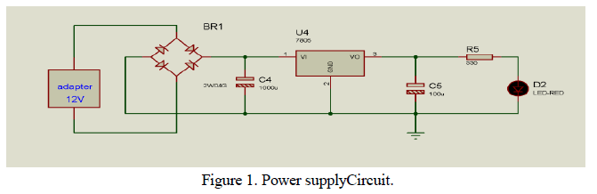
| Step 1: Design the power supply circuit Summary of circuit features |
| • Brief description of operation: Gives out well regulated +5V output, output current capability of 100 mA |
| • Circuit protection: Built-in overheating protection shuts down output when regulator IC gets too hot |
| • Circuit complexity: Very simple and easy to build |
| • Circuit performance: Very stable +5V output voltage, reliable operation |
| • Design testing: Based on datasheets of all components, We have used this circuit successfully as part of many electronics projects |
| • Applications: Part of electronics devices, small laboratory power supply |
| • Power supply current: Needed output current + 5mA |
Circuit description |
| This circuit is a small +5V power supply, which is useful when experimenting with digital electronics, and easy to build. Small inexpensive wall transformers with variable output voltage are available from any electronics shop and supermarket. Those transformers are easily available, but usually their voltage regulation is very poor, which makes themless useful for digital circuit experimenter unless a better regulation can be achieved in some way. The following circuit is the answer to the problem.This circuit can give +5V output at about 150 mA current, but it can be increased to 1 A when good cooling is added to 7805 regulator chip. The circuit has over overload and therminal protection. |
 |
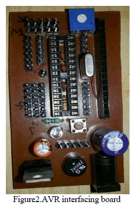
| Step 2: Development of interfacing board |
| This circuit contains the power supply circuit, AVR microcontroller, LCD Interfacing Connector, and Digital as well as Analog I/O pins. The circuit operates on 5V as well as 12V as per necessity. Using Microcontroller as per our requirements, we can use this board to interface lots of modules (i.e. GPS, GSM, Bluetooth, etc) and sensors (i.e. Metal sensor, Methane Gas sensor, Infrared sensor, Ultrasonic sensor, etc).With the help of this Interfacing board we can connect all the peripherals that are needed for this prototype to detect mines. |
 |
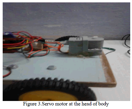
| Step 3: Connect Servo Motor for controlling the metal sensor |
| As shown in fig.3, we have attached Servo motor at the front side of robot. This servo motor can rotate from0 to 180 degree angle. Due to its position at the head of this robot we can attach the metal sensor with this servo motor. Hence this Servo will rotate from 0 to 180 degree, Meanwhile Metal sensor will sense the peripheral are and will detect the metal on or beneath the soil. |
 |
| Step 4: Connect the Metal detector and gas sensor |
Metal Detector |
| This circuit is most useful for security checking. Metal Detectors available in the market are quite expensive. This metal detector can be used to detect slightly big size metallic objects. It used a sensing coil. This coil should be kept near metallic objects for detection. Input of circuit is a weak colpitt’s R.F. range Oscillator. Sensing coil forms parts of tunes oscillator. When coil is brought near a metallic object magnetic energy is absorbed and oscillator fails to work. Then final transistor conducts and buzzer is activated. |
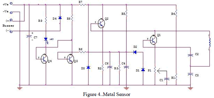 |
| The heart of this sensor is the inductive oscillator circuit which monitors high frequency current loss in coil. The circuit is designed for any metallic body detection by detecting the variations in the high frequency Eddy current losses. With an external tuned circuit they act as oscillators. Output signal level is altered by an approaching metallic object. |
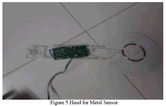 |
| Output signal is determined by supply current changes. Independent of supply voltage, this current is high or low according to the presence or the absence of a close metallic object. This hand can easily attach on the Servo motor, hence it will detect the metallic objects in land. |
Gas Sensor |
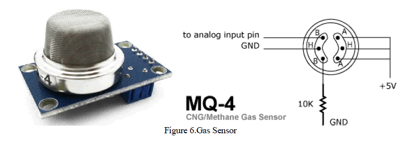
| MQ-4 gas sensor has high sensitivity to Methane, also to Propane and Butane.When the target combustible gas exist, the sensor’s conductivity is higher along with the gas concentration rising. The sensor could be used to detect different combustible gas, especially Methane; it is with low cost and suitable for different application. |
| (A) Characteristics |
| Good sensitivity to Combustible gas in wide range, High sensitivity to Natural gas, Long life and low cost, simple drive circuit |
| Application |
| Domestic gas leakage detector, Industrial Combustible gas detector, Portable gas detector |
(C) Features |
| Wide detecting scope Fast response and High sensitivity, Stable and long life Simple drive circuit |
| Structure and configuration of MQ-4 gas sensor is as shown in Fig. 7. Here sensor is composed by micro AL2O3 ceramic tube, Tin Dioxide (SnO2) sensitive layer, measuring electrode and heater are fixed into a crust made by plastic and stainless steel net. The heater provides necessary work conditions for work of sensitive components. The Sensitive material of MQ-4 gas sensor is SnO2, which with lower conductivity in clean air.Enveloped MQ-4 has 6 pin, 4 of them are used to fetch signals, and other 2 are used to provide heating. |
Sensitivity Adjustment: |
| Resistance value of MQ-4 is difference to various kinds and various concentration gases. So,when usingthese components, sensitivity adjustment is very necessary. To calibrate the detector for5000ppm ofCH4 concentration in air and use value of Load resistance (RL) about 20KΩ(10KΩ to 47KΩ).When accurately measuring, the proper alarm point for the gas detector should be determined afterconsidering the temperature and humidity influence. |
 |
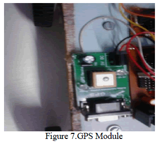
GPS Module |
| The Global Positioning System (GPS) is a space-based satellite navigation system that provides location and time information in all weather conditions, anywhere on or near the Earth where there is an unobstructed line of sight to four or more GPS satellites. The system provides critical capabilities to military, civil and commercial users around the world. It is maintained by the United States government and is freely accessible to anyone with a GPS receiver. |
| The GPS module contains SR-91 IC which receives data from the satellites with the help of antenna. The GPS module receives data in the form of NMEA (National Marine Electronics Association) standards. GPS receiver communication is defined within this specification. Most computer programs that provide real time position information understand and expect data to be in NMEA format. |
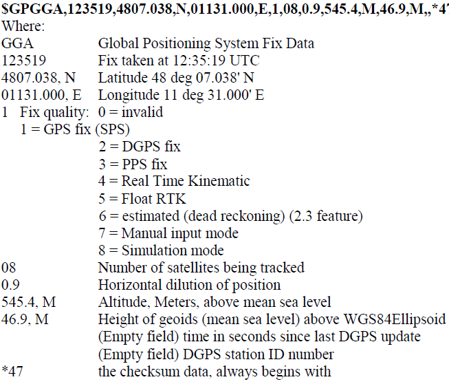
| This data includes the complete PVT (position, velocity, time) solution computed by the GPS receiver. The idea of NMEA is to send a line of data called a sentence that is totally self-contained and independent from other sentences. There are standard sentences for each device category and there is also the ability to define proprietary sentences for use by the individual company. All of the standard sentences have a two letter prefix that defines the device that uses that sentence type. (For GPS receivers the prefix is GP). |
 |
NMEA sentences |
| NMEA consists of sentences, the first word of which, called a data type, defines the interpretation of the rest of the sentence. Each Data type would have its own unique interpretation and is defined in the NMEA standard. The GGA sentence shows an example that provides essential fix data. Other sentences may repeat some of the same information but will also supply new data. Whatever device or program that reads the data can watch for the data sentence that it is interested in and simply ignore other sentences that is doesn't care about. In the NMEA standard there are no commands to indicate that the GPS should do something different. Instead each receiver just sends all of the data and expects much of it to be ignored. Some receivers have commands inside the unit that can select a subset of all the sentences or, in some cases, even the individual sentences to send |
Example of NMEA string |
 |
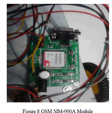
GSM Module |
| AT+CIPSPRT=0 GSM-900 uses 890 - 915 MHz to send information from the Mobile Station to the Base Transceiver Station (uplink) and 935 - 960 MHz for the other direction (downlink), providing 124 RF channels (channel numbers 1 to 124) spaced at 200 kHz. Duplex spacing of 45 MHz is used. In some countries the GSM-900 band has been extended to cover a larger frequency range. This 'extended GSM', E-GSM, uses frequency range 880 - 915 MHz (uplink) and 925 - 960 MHz (downlink), adding 50 channels (channel numbers 975 to 1023 and 0) to the original GSM-900 band. The GSM specifications also describe 'railways GSM', GSM-R, which uses frequency range 876 - 915 MHz (uplink) and 921 - 960 MHz (downlink). Channel numbers 955 to 1023. GSM-R provides additional channels and specialized services for use by railway personnel. All these variants are included in the GSM-900 specification. |
 |
| Step 5:Implement All Peripherals to One Body |
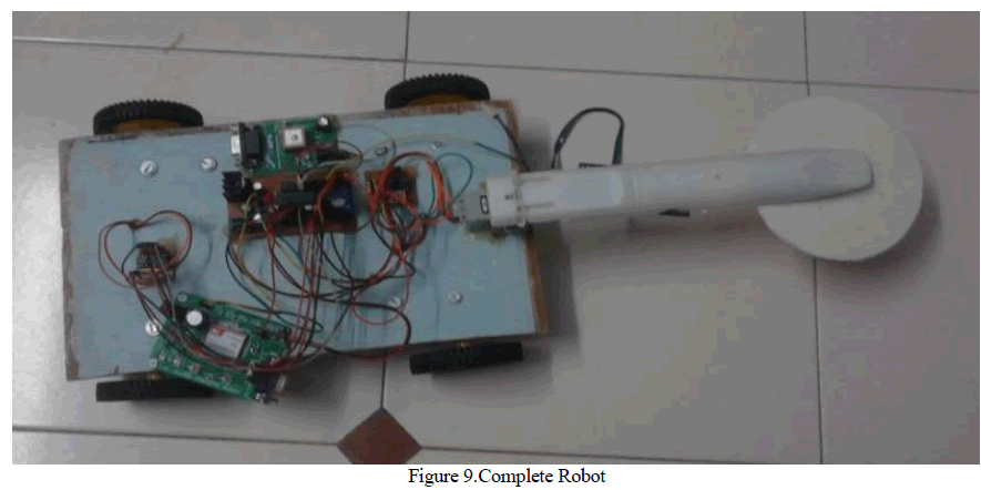 |
| All Peripherals like GSM, GPS, Controller, Metal Sensor, servo motor etc. Implement in one body as shown in figure 9.Body should be strong enough to bare the unexpected explosion. The connections are shown in design simulation. Make sure that any connection is not loose or shorted. |
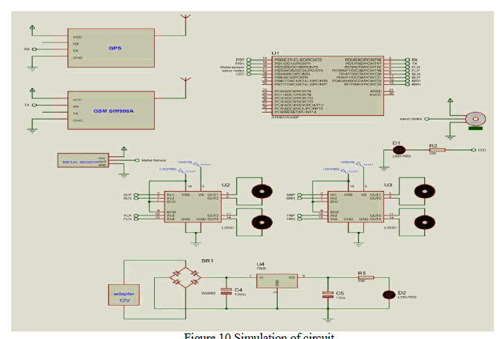
IV. CIRCUIT SIMULATION AND WORKING OF SYSTEM |
| Combining all the circuits we are able to get final circuit of this working prototype. This circuit is as shown in Fig.10. |
 |
 |
V. EXPERIMENTAL RESULTS |
| By performing experiments several times on field we are able to get high accuracy in detection. Also we tried to detect mines for varies ranges under the soil. |
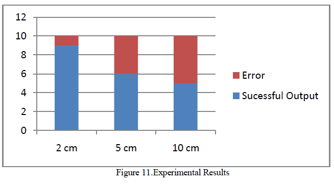 |
| As per above fig., we placed metal object at 2cm beneath the soil and then we tried to detect that object. We performed this task for 10 times and we were able to get 90% accuracy at this range. Then we placed the metal object at 5cm under the soil. At this time we got 60% successful result in detecting the metal. At the end we put the metal object deeper inside the soil (Approx. 10cm). For this range we were able to get only 50% accuracy in the detection. By averaging all these results we found that this prototype can detect maximum numbers of mines at the range from 2-5cm beneath the soil. All these experimental results for various ranges are as shown in the fig 11. |
VI. CONCLUSION AND FUTURE WORK |
| It has been successfully proven through this proposed theory and concepts for a landmine exploring platform works perfectly. It will able to clear the path with 1m width at one go. The greatest advantage that this robot offers is the safety for the soldiers on war field. It will send the location of buried mine to the operators by using GSM module. This means that if the operator or the soldiers follow the tire tracks, they are perfectly safe since the robot has already rolled over it. Thus, the proposed design for landmine detection and marking module had opened up a new area for the researchers to explore. Saving the lives and limbs of innocent civilians becomes one step closer. In future we can also use the camera for better images of buried mines. |