International Journal of Advanced Research in Electrical, Electronics and Instrumentation Engineering
ISSN ONLINE(2278-8875) PRINT (2320-3765)
ISSN ONLINE(2278-8875) PRINT (2320-3765)
Pratik K. Gaikwad1, Sushant J. Pawar2
|
| Related article at Pubmed, Scholar Google |
Visit for more related articles at International Journal of Advanced Research in Electrical, Electronics and Instrumentation Engineering
This paper describes a novel method to design a simple real time GPS (Global Positioning System) receiver system for navigation, positioning and tracking applications. This system is developed to provide various positioning and navigational parameters like latitude, longitude, velocity, altitude, the name of the current location etc. This system also provides information regarding the satellites which are in view in terms of the number of satellites being tracked, satellite ID/PRN (Pseudo Random Noise) number and parameters like SNR (Signal to Noise Ratio) of the satellite signal, azimuth and elevation. All the information is displayed on Graphical User Interface (GUI). The presented GPS receiver system uses a hardware GPS receiver provided with a (USB) (Universal Serial Bus connector) so that the receiver is compatible and can be easily connected to a PC (Personal Computer) or a laptop. An antenna is connected to the GPS receiver to acquire the signals from the satellites. There should be line of sight between the antenna and the satellite. The software used for this system is developed in VB.NET (visual basic.NET) programming language. VB.NET is an application oriented computer programming language which is easy to program and understand. The main feature of this system is the ease of use of the system and visual display of the results which can be seen on a PC or laptop.
Keywords |
||||||||||
| Global Positioning System (GPS), Graphical User Interface (GUI), visual basic .NET (VB.NET), Personal Computer (PC), Navigation, Position. | ||||||||||
INTRODUCTION |
||||||||||
| The determination of the position and velocity of a moving entity on land, at sea, in the air, or in space is called navigation [1]. In navigation the location or the position and its parameters are required immediately or after certain maximum delay [8]. This is called real time requirement [8]. In navigation the position information is not fixed i.e. it is variable and is time dependant [8]. In the olden days, before the existence of modern technologies, one was dependant on landmarks and distances estimated from travel times for navigation [8]. Nowadays, airplanes, missiles, spacecraft, large sea vessels, ships, vehicles that move on dry land and even pedestrians make use of modern technology for navigation. This technology is called GPS (Global Positioning System). There are many technologies available for navigation but since GPS provides global coverage and better accuracy compared to other systems, it is mostly used for navigation. There are other GNSS (Global Navigation Satellite Systems) like Russian GLONASS (Global Navigation Satellite System), which also provide global coverage and real time results. But GPS provides better accuracy as compared to other GNSS. | ||||||||||
| There are many GPS receiver systems available in the market. But many of them are expensive, bulky and require internet connection. The GPS applications available on mobile phones show tracking on maps but they too require internet availability for navigation. Hence, it is necessary to design and build a real time GPS receiver system which is of compact size, cheap, does not require internet connection for navigation and is compatible to a PC or a laptop. In this paper, a real time GPS receiver system is discussed. The system consists of a GPS antenna, GPS receiver with a USB connector, GPS software which is developed in VB.NET and a personal computer or a laptop for GUI display. | ||||||||||
| First the GPS system is discussed in section II. Section III provides the details of related work. The system design is discussed in section IV. The system execution flow is shown in section V. Finally section VI shows the system results | ||||||||||
II.GPS OVERVIEW |
||||||||||
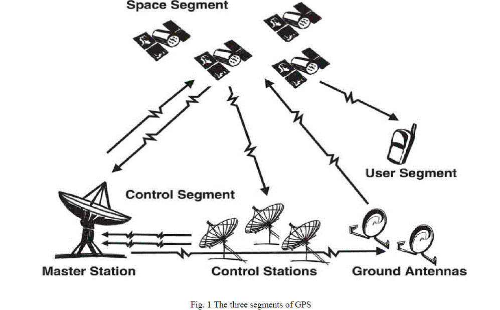
| NAVSTAR (Navigation Satellite Timing and Ranging) is a network of U.S. satellites that provide global positioning system (GPS) services. It is used for navigation by both the military and civilians. The GPS system consists of three segments: the space segment, the control segment and the user segment. The segments of GPS are shown in the fig. 1. | ||||||||||
 |
||||||||||
| All the three segments are described in detail as follow | ||||||||||
| The space segment: The GPS space segment consists of constellation of minimum 24 operational satellites. This 24 satellites core constellation ensures that the GPS receivers can view at least 4 satellites from any point on the planet. The satellites in the GPS constellation are arranged in six orbital planes which are equally spaced. Each orbital plane consists of four satellites. All these satellites fly in the MEO (Medium Earth Orbit) at an altitude of about 20,200 km from the surface of the earth. Presently there are 27 operational satellites. The extra three satellites improve the GPS performance but are not considered part of the core constellation. The satellite signal received by the GPS receiver consist of satellite orbital and clock information, information and status concerning all the satellites and a global ionospheric model for ionospheric error correction. The satellite signals are timed using highly accurate atomic clocks. | ||||||||||
| Control segment: The control segment controls the satellites. The control segment consists of global network of ground facilities that track the GPS satellites, monitor their transmission, perform analysis and then provide them with corrected orbital and clock information. The current operational control segment consists of a Master Control Station (MCS), an alternate master control station, four ground antennas and six monitor stations. The monitor stations continuously receive the data from the satellites and then send that information to the master control station. The master control station receives navigation information from the monitor stations, corrects the satellite data and sends this information to the GPS satellites using the ground antennas. | ||||||||||
| User segment: The user segment consists of military and civilian GPS receivers. The GPS receiver can be held in hand or can be mounted on the vehicle. The receiver processes the GPS satellite signal to obtain precise position and navigation parameters. | ||||||||||
III.RELATED WORKS |
||||||||||
| Many researchers have designed and developed GPS receiver systems using various hardware and software technologies. Many scientists have done research on GPS satellite signals tracking, acquisition and processing and have suggested improved techniques. Many researchers have designed and build numerous applications in number of fields like agriculture, mining, banking etc. by interfacing GPS with other hardware or software technologies. A GPS receiver system having a software radio approach is proposed in [2]. The GPS satellites signals are digitized as soon as possible near the antenna and then digital signal processing is used to obtain the necessary information [2]. A handheld GPS receiver designed using microcontroller 89C51 and a GPS hardware module used to provide location based emergency services information is also developed [3]. Implementation of a complete GPS receiver simulation and implementation on C6713 DSP (Digital Signal Processor) using SIMULINK graphical programming language is proposed in [4]. A method for integrating Inertial Navigation System (INS) sensors with GPS measurements to estimate key vehicle states like body sideslip angle, tire sideslip angle and vehicle attitude is presented in [5]. Also another method to provide direct measurements of vehicle roll and heading which results in improved sideslip estimation is discussed in [5]. An automobile localization system which sends the position and localization of the automobile to the owner in the form of a SMS (Short Message Service) using GPS and GSM (Global System for Mobile Communication) technology is also designed [6]. An expandable GPS and GSM systems simulator allows the user to learn the advantages of wireless technology and use it in GPS navigation [7]. | ||||||||||
IV.SYSTEM DESIGN |
||||||||||
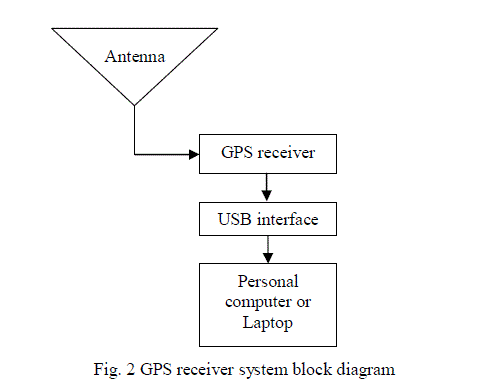
| The system is composed of hardware as well as software. The system hardware is interfaced with the system software. The results of the system are displayed in the form of visual displays on the PC or laptop screen. The fig. 2 shows the system design. | ||||||||||
 |
||||||||||
| The system hardware and the system software are described in detail as follows, | ||||||||||
| System hardware: | ||||||||||
| The system hardware consists of an antenna, GPS receiver, USB (Universal Serial Bus) interface and a PC or laptop. | ||||||||||
| 1. Antenna: The antenna used is an active antenna. The antenna receives power supply from the GPS receiver. The antenna is tuned to the frequency of about 1575.42 MHz which is the L1 (Link1) frequency component of GPS satellite signals. The L1 frequency component is available for civilian use. The antenna receives the L1 frequency satellite signals. These signals received by the antenna are given to the GPS receiver. The antenna continuously receives the satellite signals | ||||||||||
| 2. GPS receiver: The L1 frequency signals from the antenna are received by the GPS receiver. The GPS receiver generates the information strings in the NMEA-0183 (National Marine Electronics Association- 0183) protocol format. A RoyalTek REB-1315S4 GPS module is used in the GPS receiver. The GPS module continuously tracks the satellites and acquires the satellite signals. The GPS module processes the satellite signals and generates the NMEA-0183 information strings. The information strings are available at USB connector output. The receiver draws power form the PC or laptop to which it is connected. The GPS receiver provides real time GPS position, latitude, longitude, speed, altitude (above mean sea level), course over ground with respect to true north, number of those satellites whose signals are being received i.e. the number of satellites which are being tracked by the receiver, satellite ID/PRN number, information of each satellite which is being tracked in terms of parameters like azimuth, elevation and SNR in the NMEA-0183 format such as GPGGA (Global Positioning Global positioning system fixed data), GPGSA (Global Positioning GNSS DOP (Dilution of Precision) and active satellites), GPGSV (Global Positioning GNSS satellites in view), GPRMC (Global Positioning Recommended minimum specific GNSS data), GPGLL (Global Positioning Geographic position latitude/longitude), GPVTG (Course over ground and ground speed) to the PC or laptop. The GPS receiver is compact and small in size. | ||||||||||
| 3. USB interface: The USB interface consists of USB connector. The USB interface sends the NMEA-0183 information strings from the GPS receiver to the PC or laptop. The USB connector is interfaced with the GPS receiver and is compatible to any PC or laptop USB port | ||||||||||
| 4. Personal computer or laptop: The NMEA information strings from the GPS receiver are received by the personal computer or the laptop through the USB connector. These strings are processed in the PC or the laptop by the software module which is programmed in VB.NET. The in view GPS satellites information and various navigation and location based parameters are displayed in the textboxes on the GUIs. The NMEA information strings are being continuously received by the laptop and are also displayed on the GUI. Minimum required configuration of the PC or laptop is 512 MB (Mega Bytes) RAM (Random Accesses Memory), 40 GB hard disk, Pentium processor and a USB port. | ||||||||||
| System software: | ||||||||||
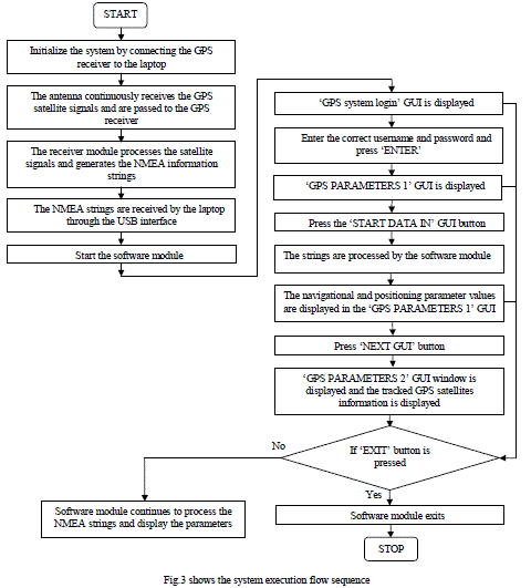
| The software module is programmed in VB.NET application oriented programming language. The NMEA-0183 information strings are processed by the software module and the GPS satellites information and various navigation and location based parameters are extracted from the strings. These extracted parameter values are then displayed in textboxes on the GUIs. Two GUIs display all the parameters. A user login GUI is also designed. This user login GUI is called ‘GPS system login’. Upon entering correct user name and password the user will be directed to the next GUI. This GUI is called ‘GPS PARAMETERS 1’. The ‘GPS PARAMETERS 1’ GUI displays the parameters like latitude, longitude, altitude (above mean sea level), speed, HDOP (Horizontal Dilution of Precision), course over ground with respect to true north, the present location names and the number of satellites used i.e. the number of satellites tracked by the GPS receiver. The ‘START DATA IN’ GUI button starts the display of parameters. The ‘NEXT GUI’ button given in the ‘GPS PARAMETERS 1’ GUI is the link to the next GUI i.e. ‘GPS PARAMETERS 2’. This GUI displays the number of satellites used i.e. the number of satellites which are being tracked by the receiver and the information of each satellite which is being tracked in terms of parameters like satellite ID/PRN number, azimuth, elevation and SNR. Upon pressing the ‘EXIT’ button in any of the GUIs the application exits. The minimum configuration for the software to run is Microsoft Visual studio 2005/08/10 and Dot net framework 2.0. The designed software module is easy to operate and is user friendly | ||||||||||
| The system requires minimum hardware and software configuration. Hence, it is easy to design and develop the system. | ||||||||||
V. SYSTEM EXECUTION METHODOLOGY |
||||||||||
| The system flow chart is shown in the fig. 3. The flow chart describes the system working in detail. All the system processes and stages from the stage of initialization till the system exit and their interlinking are presented in the flowchart | ||||||||||
 |
||||||||||
VII. RESULTS |
||||||||||
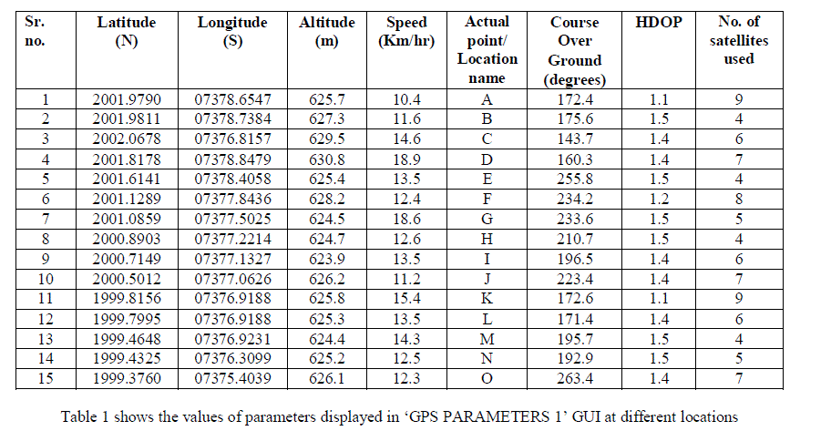
| To evaluate the performance of the developed real time GPS receiver the real time results of the system were taken. The tested results are tabulated in table 1 and 2. | ||||||||||
 |
||||||||||
| The real time values of Latitude, Longitude, Altitude (above mean sea level), speed, actual point/location name, course over ground, HDOP and number of satellites being tracked are tabulated in table 1. The real time locations are tabulated in sixth column but for brevity they are written in symbolic form. | ||||||||||
 |
||||||||||
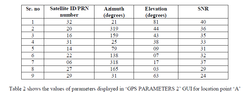
| The GPS receiver receives signals from number of satellites i.e. the receiver tracks the satellites which are in view. The information of these satellites in terms of satellite ID/PRN number, azimuth, elevation and SNR for location point ‘A’ are tabulated in table 2. The values of parameters given in table 2 are obtained from ‘GPS PARAMETERS 2’ GUI. The results of the system are as accurate as the most sophisticated systems available in the market. The system displays all the necessary positioning and navigational parameters along with satellite information. Hence, this system can be used in number of fields like transportation, oil and mining industries, agriculture, animal tracking and space applications. Number of applications can be developed using this system and can be used various fields. | ||||||||||
VIII. CONCLUSION |
||||||||||
| In this paper a real time GPS receiver is investigated. The system is studied and is developed successfully. The system is designed and developed in hardware as well as in software. Hence, the system consists of hardware module as well as software module. The system provides positioning and navigational information in terms of number of parameters. Also information regarding the satellites which are being tracked by the system is also displayed. The developed system is compact, low cost and reliable. The results obtained by the system are given in the paper in tabulated forms. Using the same system internet based applications and mobile based messaging applications can also be developed. Since this system provides global coverage, this system can be used anywhere on the planet provided that decent signals from at least four satellites are received. | ||||||||||
ACKNOWLEDGEMENT |
||||||||||
| I offer my thanks to all who have supported and helped me in any respect during the completion of the paper. I am grateful to my guide Prof. Sushant J. Pawar for giving helpful insights and suggestions during the completion of the paper | ||||||||||
Tables at a glance |
||||||||||
|
||||||||||
Figures at a glance |
||||||||||
|
||||||||||
References |
||||||||||
|


