Research & Reviews: Journal of Engineering and Technology
ISSN: 2319-9873
ISSN: 2319-9873
1 National Advance School of Engineering of Yaoundé, Electrical and Telecommunications Department, ACL Laboratory, PO BOX: 8390, Cameroon
2 University of Yaoundé I, Science Faculty, Department of Physics, PO BOX: 812, Cameroon
3 National Advance School of Engineering of Yaoundé, Mechanical and Industrial Department, 3E Laboratory, PO BOX: 8390, Cameroon
4 Mekin Hydroelectric Development Corporation (HYDRO-MEKIN) P.O. BOX: 13155 Yaoundé-Cameroon
Received: 04 April 2013 Accepted: 26 April 2013
Visit for more related articles at Research & Reviews: Journal of Engineering and Technology
This work shows the results obtained from the design of the Earth Dam for the Mekin Hydropower project. This water retaining earth dam design includes the water retaining parts of the main dam and the auxiliary dam. To begin, the basic design data which includes the class of the water retaining structures, flood standard, characteristic water level and fetch length are determined. The work continues with the presentation of the exact location, and the different structures that constitute the earth dam. The dam slope and crest which make up the dam body are also presented followed by their sizing. In addition a study of the seepage-proofing soil and filling material of the dam body is done
main dam, auxiliary dam, design.
The Mekin hydroelectric dam situated in the south region of Cameroon located after the confluence of the rivers Dja, lobo and Sabe, is constructed to produce 15MW. The main dam and auxiliary dam constitute a reservoir of approximately 11010km2 with a volume of about 2×10⁸m3.
The main dam and auxiliary dams are earth dams and their sizing, have presented a major challenge for African engineers and experts notably due to lack of documentation and sometimes experience. This work seeks to propose a simplified methodology based on international standards and a case study. It presents concrete results which are being implemented on the construction site of the dam. The earth dam is composed of principally the dam slope, dam crest and the dam body [1,6]. In this work, the basic design data necessary for the studies is presented. In this light, the class of water retaining structures, flood standard, characteristic water level, wind speed and fetch length are treated. The discussion of the dam body structures follows with the specification of its location, and arrangement of structures. In addition, the seepage-proofing soil and filling material of the dam body are treated in detail. Finally aspects of the dam body structure that include zoning of dam body, dam slope and dam crest elevation are discussed in detail.
(1) Main dam class 2
(2) Auxiliary dam class 2

Table 1-1: Characteristic water level of reservoir
(1) Average annual maximum wind speed 10.60m/s
(2) Fetch length 585.00m (main dam)
550.00m (aux.dam)
The main dam is connected to the approach road. The main dam is on the right side of the power station on the second order bottomland of Dja River. It is on the same axis of the power station, floor discharge sluicing gate, floating debris sluicing gate and overfall dam.
The total length of the main dam water retaining dam is 488.00m. See table 1-2 for parameters of control points.

Table 1-2: Parameters of main dam control points
The water retaining dam of the auxiliary dam is at the mountain massif cove on the left bank of the Dja River. The dam axis has a 137.76 angle width the axis of the main dam toward the upstream.
The total length of the water retaining dam of the auxiliary dam is 295.00m. See table 1-3 for parameters of control points.

Table 1-3: Parameters of auxiliary dam control points
The seepage – proofing soil for the main and auxiliary dams is borrowed from the gravelly soil yard near Ekon Primary school on the right bank downstream of the dam site.
See Tables 1-4 and 1-5 for the particle diameter and quality index evaluation.

Table 1-4: Particle diameter of soil unit: %

Table 1-5: Evaluation of soil quality indices
According to indoor test of compacted soil, the design values of seepage-proofing soil body of the main and auxiliary dams are shown in table 1-6 [8, 10].

Table 1-6: Physico-mechanical indices of compacted soil
The abandoned residues from the excavated main dam foundation, flood discharge sluicing gate, power station foundation pits and rain water channel are used as filling material for the main dam body. The abandoned residues from the excavated auxiliary dam foundation and link road between the main and the auxiliary dams are used as filling materials for the auxiliary dam body. If it is not sufficient, the rest is borrowed from the second order bottomland 100.00m downstream the main and auxiliary dams. The residues are mixed fillings for sand loam, silty sand, sand with gravel, medium coarse sand, gravel, chlorite schist.
See table 1-7 for composition of residues from each position and the physico-mechanical indices.

Table 1-7: Composition of residues excavated from each position and the physico-mechanical indices
See Table 1-8 for design values of soil material used for the main and auxiliary dams.

Table 1-8: Design indices of mixtures for dam body
In the principle of the using local materials and balancing filling cutting, the zoning of various materials for the main and auxiliary dam bodies are listed in table 1-9

Table 1-9: Zoning of dam body (from up to down)
In accordance with the characteristics of the type , height , structures class , dam body material and foundation of the main and the auxiliary dams and construction and application conditions , the same single slope is used for downstream of the main and the auxiliary dams. The slope ratio of the upstream dam face is 1:2.75 the slope ration of the downstream dam back is 1:2.00.
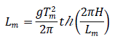
The dam crest elevation is equal to the sum of static water level of reservoir and dam crest super elevation, and it is calculated with the following application conditions, the maximum value is taken [9,10]:
(1) Dam crest superelevation of design food level plus normal application condition
(2) Dam crest superelevation of normal storage level plus normal application condition
(3) Dam crest superelevation is calculated with this formula:
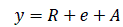 (Eq 1)
Where: y- Dam crest superelevation, m
R- Altitude of maximum wave on the dam slope, m
e- Maximum height of water surface is wind, m
A- Safety height added
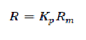 (Eq 2)
Where:Rm - Average altitude of wave, m:
Kp- Ratio of wave altitude in different accumulative frequency to average wave altitude
According to engineering order, design wave altitude value is the altitude value R1% whose cumulative frequency is 1%.
The upstream dam slope of the main dam and the auxiliary dam is 1:2.75, the side slope gradient is m=1.50-5.00, the average wave altitude is:
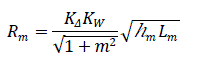 (Eq 3)
Where: m- Gradient factor for single slope
KΔ Slope coarse frequency permeability coefficient, 0.80 is used;
Kw Experience coefficient:
hm Wave element average wave height, m;
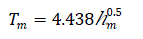
Lm Wave element, average wave length, m
Average wave height and average wave cycle are calculated with Putin Testing station formula:
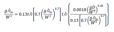 (Eq 4)
 (Eq 5)
 (Eq 6)
Where: Tm-average wave cycle, s;
W-calculated wind speed, m/s;
D-Fetch length, m;
Hm- average depth of waters, m;
g- Gravity acceleration, 9.81m/s
H- Water depth in front of dam face, m.
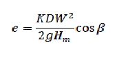
The height of water surface in wind is calculated with the following formula:
 (Eq 7)
Where: e- water surface height in wind at the calculating point, m;
K- General friction coefficient, K=3.60×10⁻⁶;
β- Calculated included angle between wind direction and dam axis normal, degree.
Parapet walls are not provided on the crests of the main and the auxiliary dams. The calculated dam crest elevation is design elevation of the dam crest .
See table 1-9 for calculated results of dam crest elevation.

Table 1-9: Calculated results of dam crest elevation unit:m
In combination with the transportation and management requirements, and in consideration of traveling convenience for the villagers in forest areas on the banks of Dja River, there is no special requirement for the width of the dam crest. Therefore, the transportation inside the area are designed as one lane road, i.e the width of both the main and auxiliary dams is 4.00m, the power station, flood discharge sluicing gate, overfall dam, masonry gravity dam, main and auxiliary dams are all connected with 4.00m wide roads to main dam and the auxiliary dam.
Pavement structure: 0.20m concrete pavement, 0.20m broken stone road bed.
Earth seepage-proofing body zoned dam is used for both the main and auxiliary dams.
Gravelly soil borrowed from Ekok Primary school is used for the seepage- proofing body.
The slant wall seepage- proofing body is thickened gradually from up to down. The width of the top is 2.00m, the upstream slope is 1:2.75, the downstream slope ration is 1:2.00. When the maximum bearing water head of the main dam slant wall is 8.05m, the bottom thickness is 3.00m; when the maximum bearing water head of the auxiliary dam is slant wall is 5.30m, the bottom thickness is 2.40m. Both the slant wall thickness and bearing water head ration must meet the specification by not less than 1/5. The elevation of the seepage- proofing body top is 614.80m. It is directly connected to the dam crest road surface.
Upstream of the seepage – proofing body is provided with 0.20m broken stone transition layer and 0.30m fine sand reverse filtration layer too.
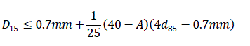
According to the table 1-4, the content of particles below 0.075mm in the seepage-proofing gravelly soil is 38.40%. Requirements for filtering soil [10]:
 (Eq 8)
Where: A-Content of particles whose diameter is less than 0.075mm, %;
D15- Weight of soil with reverse filtered particles smaller than this diameter covers 15% of the total soil weight, mm;
d85-Weight of protected soil with articles less than this diameter covers 85% of the total weight of soil, mm.
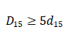 (Eq 9)
Where: d15 weight of protected soil with particles less than this diameter covers 15% of the total weight of soil, mm.
According to table 1-4, A=38.40, d15=0.0265mm, d85=diameter of fine sand particles in the reverse filtration layer in upstream and downstream of gravelly soil slant walls must meet the following requirement:
0.135mm≤D15≤1.90mm
Both upstream and downstream of the gravelly soil slant wall must be provided with 0.30m fine sand reverse filtration layer.
Dry masonry slope face drainage is adopted for both the upstream and downstream of the main and auxiliary dams.
Based on the dam seepage calculation, the dam slope escapement points at downstream of the main and the auxiliary dams are low, the drainage body is 1.00m higher than the dam flood ground, so it is built with rock blocks, the average thickness is 0.45m, and 2.00m wide banket is provided for the drainage body foot.
Rock blocks are used to protect the upstream slopes of the main and auxiliary dams while wood frame sod is used to protect the downstream slopes.
Upstream slope protection [10].
The rock mass and thickness for slope protection is calculated with the following formulas:
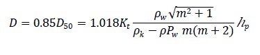 (Eq 10)
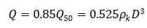 (Eq 11)
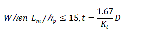 (Eq 12)
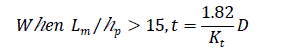 (Eq 13)
Where: D - conversed ball diameter of rock block, m;
Q- mass of rock block, t;
D50-average diameter of rock block, m;
Q50-average mass of rock block, t;
t- thickness of slope protection, m;
Kt-coefficient varying with the slope ratio;
Pk-density of rock block, t/m3;
Pw- density of water, t/m3;
hp- wave height whose accumulative frequency is 5%
Refer to table 1-10 for parameter calculation results upstream slope protection thickness.

Table 1-10: Calculation results of slope protection thickness
Through calculation, both the particle diameter and thickness of the upstream slope protection of the main and auxiliary dams are small, so the thickness of 0.30m is used for design according to the structure.
The slope protection is made from the dam foot to the dam crest. Dry masonry substrate is provided at the dam foot, the dam crest is connected to the curbs.
The downstream wood frame sod slope protection is made from the dam crest to the slope face drainage body. The frame size is 3.00m×3.00, the wood height is 0.30m, the thickness is 0.02m, the earth in the frame by 0.30m, sodding is done in the frame.
The objective of this work was to design the main dam and auxiliary dam of the Mekin hydro electric plant.
The simplified methodology used in the design of the Mekin Earth dam was based on international standards. Concrete results were obtained which are being implemented on the construction site of the dam.
Detailed studies of the basic design data and the arrangement of structures enabled us determining the dam building materials to be used and filling requirements for the seepage proofing soil and the dam body structure.
Through evaluation and calculations, it was concluded that the main dam is a gravelly soil sand- gravel dam. The dam crest elevation is 615.20m, the dam crest width is 4.00m, the maximum dam height is 9.45m, the slope ration of the upstream dam face is 1:2.75, and the slope ratio of the downstream back is 1:2.00. The type of auxiliary dam is completely the same as that of the main dam. Gravelly soil sand-gravel dam is used, the dam crest elevation is 615.20m., the dam crest width is 4.00m, the maximum dam height is 6.70m, the slope ratio of the upstream dam face is 1:2.75, the slope of the downstream back is 1:2.00. And for each dam, grating gabions are used on the upstream of the dam body for slope protection and wood frame sod is used on the downstream for slope protection. Dry masonry is used at the dam foot for drainage on the slope. Cutoff trench is provided in the dam foundation for seepage proofing, gravel earth is backfilled deep into the base rock.