Keywords |
| Wireless Sensor Networks (WSN), tracking, localization, received signal strength indicator,
triangulation |
INTRODUCTION |
| Localization has its own importance in wireless sensor network scenario. The important function of a sensor network
is to collect and forward data to destination. It is very important to know the location of the data from where it is
collected. This kind of information can be obtained using localization technique in wireless sensor networks..
Localization of sensor nodes is an interesting research area and many works have been done so far is highly desirable to
design low-cost, scalable and efficient localization mechanisms for WSNs. It is a way to determine the location of the
sensor nodes Localization is estimated through communication between localized node and unlocalized node for
determining their geometrical placement or position. Location of the sensor node is determined by means of distance
and angle between nodes. There are many concepts used in localization such as lateration, angulation, trilateration and
triangulation. Localization schemes are classified as anchor based or anchor free, centralized or distributed, GPS based
or GPS free, fine grained or coarse grained, stationary or mobile sensor nodes and range based or range |
| The two fundamental principles used in traditional localization techniques are triangulation and trilateration. The
triangulation method employs antenna arrays and tries to estimate the direction of signal from a to-be-located radio
source. At least two such estimates are required from two antenna arrays located at two different locations. The location
of the signal source can be estimated at the intersection of lines of directions from the two antenna arrays. AoA also
called as direction of arrival (DoA), is a localization approach belonging to the triangulation methods. A receiver (e.g.,
a base station) uses the angle of received signals from a mobile device to limit the location of a mobile device along a
line. Thus at least two base stations are required to locate the mobile device by taking the intersection of two lines of
directions from the two antenna arrays. The base stations have to be equipped with an antenna array or a directional
antenna for calculations of the angle of the received signals. The localization algorithm uses the measured RSS to find a
best matching location from the radio map and predicts if the MU is in the location |
RELATED WORK |
| In a target tracking application, the sensor nodes which can sense the target at a particular time are kept in active
mode while the remaining nodes are to be retained in inactive mode so as to conserve energy until the target approaches
them. To continuously monitor mobile target, a group of sensors must be turned in active mode just before target reaches to them. This group of active sensors varies depending on the velocity of moving target and schedule from
cluster head. Ultimately, target tracking in course of maintaining the balance between network resources like energy,
bandwidth, and overheads is challenging. |
| Ring Overlapping Based on Comparison of Received Signal Strength Indicator (Chong Liu et. Al. 2007) in which
every sensor node will have a series of overlapping rings to narrow down the possible area in which it resides. The
signal strength a particular sensor node receives from a specific anchor is compared with the signal strength other
anchors receive from the same anchor node are used to generate the rings. It does not map the received signal strength
to absolute point to point distances Approximate Point In Triangulation (Yong Zhou et. Al. 2009) is a range free
localization method. In this method the node chooses three anchor nodes from all other audible anchors and tests
whether it is inside the triangle formed by connecting these anchors. APIT repeats the PIT test with different audible
anchor combinations to get the required accuracy. After that it calculates the centre of gravity of all the triangles to find
where the node resides. APIT can only evaluate finite number of directions and it makes incorrect decisions when three
conditions exist. To track the pilgrim movement during Hajj (Mohamed Mohandes et. Al. 2012) a method is proposed
with a dedicated delay tolerant wireless sensor network. In this method each pilgrim is given a mobile sensor unit
which includes a GPS chip, a microcontroller and an antenna. Fixed network units are installed to receive and forward
data from the sensor nodes. These fixed nodes are connected to a central server which maps the latitude and longitude
to the geographical information system. Gateways are used to interface the WSN via internet to the central server. The
main drawback of this system is the use of GPS in the sensor node takes much amount of power from the node |
PROPOSED ALGORITHM |
| A. Triangulation Method: |
| Triangulation mechanism is an example for range based localization technique. It uses geometric properties of
triangles i.e trigonometric laws, laws of sine and cosine to estimate the location. In this method, atleast two angles of an
unlocalized node from two localized nodes are measured to estimate its location. |
| The Figure 1 depicts the traditional triangulation method by which the location of the sensor node is found using
Angle of Arrival method and Time of Arrival method |
| B. Description of the Proposed Algorithm: |
| Aim of the proposed algorithm for localization reduces the estimation error in finding the location and also the time
complexity in computation is reduces as the mapping of strongest signals is taken into consideration.The proposed
algorithm is consists of the following steps. |
| Step 1: Assumption |
| Assume a sensor node say ‘S’ wants to calculate its location. The total number of sensor nodes is given as input
and the simulation area is defined manually. |
| Step 2: Random Deployment of Sensor Nodes: |
| Inputted Sensor Nodes are randomly deployed and corresponding coordinates are found |
| Step 3: Collection of RSSI |
| Received Signal Strength from all the sensor nodes collected at unknown node ‘S’. |
| Step 4: Mapping of Signals |
| The Strongest signals from the collected signals are found and circles are mapped. |
| Step 5: Location computing |
| From step 4 only 3 values are taken to compute the location of the sensor ‘S’ |
| Step 6: Estimation of node position |
| Finally the Euclidean distance from the reported location vector of the mobile device is generally regarded as being the
correct estimate of the position of the sensor node. |
SIMULATION RESULTS |
| The wireless sensor network for pilgrim tracking has been evaluated with several different nodes. Simulations are
carried out in MATLAB In pilgrim tracking scenario, the terrain is restricted and hence the range based localization is
used. The Received Signal Strength Indicator values from several nodes are collected and the stronger signals are
mapped. From those signals again the two stronger signals are taken for triangulation method and thus the location of
the unknown node is found. The scenario dimension is taken as 500m x 500m. In this experiment sensor nodes are
varied from 50 to 250 nodes and the collected RSSI values in every experiment is analyzed according to the distance of
the sensor nodes. The position of the unknown sensor nodes are calculated from the found data. The figure below
shows the scenario for the node positioning of sensor nodes as well as the unknown sensor node location. |
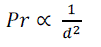
| The simulated output gives the values for received signal strength indicator with respect to the distance of the
sensor nodes. Received Signal Strength Indicator is an estimate of average received power. The strength of received power from a signal can be used to estimate distance because all electromagnetic waves have inverse-square
relationship between received power and distance as shown in the following expression: |
 --------(1) --------(1) |
| where Pr is the received power at a distance d from the transmitter. |
| The figure 3 shows the graph plotted between received signal strength received at the unknown node with respect to the
distance |
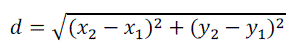
| The estimation position of the sensor node calculated using the procedure as given. For example, assume two access
points X and Y and a mobile device Z. Access point X reports mobile device Z with an RSS sample of x1. Almost
simultaneously, access point Y reports mobile device Z with an RSS sample of y1. These two RSS reports can be
represented as location vector of (x1,y1). Assume that during the calibration phase, a large population of location vectors
of the format F(x2,y2) were populated into the location server calibration database, where F represents the actual
physical coordinates of the recorded location. The location server can calculate the Euclidean distance d between the
currently reported location vector (x1,y1) and each location vector in the calibration radio map as follows: |
 -----(2) -----(2) |
| The estimation error for different nodes are tabulated below: |
| From table 1 it is clear that as the number of sensor nodes increases the estimated error also increases but by the use
of modified triangulation method the error is minimized when compared with the traditional triangulation method. Also
the computational time gets reduced by mapping the strongest signal alone for the computation purpose rather than
selecting random nodes. |
CONCLUSION AND FUTURE WORK |
| The modified triangulation algorithm (MTA) for pilgrim tracking and its working are presented in detail. The
performance of this algorithm is analyzed with the help of Received Signal Strength Indicator. It is found that MTA
performs quite better than the traditional triangulation technique. Also the average estimation error and computation
time is less when MTA is used as it is analyzed with different number of sensor nodes. The future work has to be
extended with several other parameters taken into consideration in a real time |
Tables at a glance |
 |
| Table 1 |
|
| |
Figures at a glance |
 |
 |
 |
| Figure 1 |
Figure 2 |
Figure 3 |
|
| |
References |
- Nabil Ali Alrajeh, Aryam Bashir, and Bilal Shams, "Localization Techniques in Wireless Sensor Networks", International Journal of Distributed Sensor Networks, Vol 1, pp. 1-9,June 2013.
- Mohamed Mohandes, Mohamed Haleem “Wireless Sensor Networks for Pilgrims Tracking,” IEEE Embedded System Letters, vol. 4, no.4, pp. 106-109, Dec. 2012.
- Long Cheng, Chengdong Wu, YunzhouZhang,Hao Wu “Localization in wireless sensor networks,” International Journal of Distributed Sensor Networks,Vol.2012.
- HandeAlemdar, CemErsoy, “Wireless Sensor Networks for Health care: A Survey,”International Journal of Computer and Telecommunications Networking, pp. 2688-2710, May 2010.
- MarekDoniec, Carrick Detweieler, Daniel Rus, “Autonomous gathering of livestock using a multifunctional sensor network platform,”Proceedings of the 6th workshop on Hot Topics in Embedded Networked Sensors 2010, ACM.
- JizengWang,Hongxu Jin “Improvement on APIT Localization Algorithms for Wireless Sensor Networks,” International Conference on Network Security,Wireless Communications and Trusted Computing, vol. 1, April. 2009
- ApurvaJoshi,NagaVishnuKanth I, SumitBagla and Prabhat Ranjan,“GPS-Less Animal Tracking System”,Fourth International Conference on Wireless Communic ation and Sensor Networks, 2008.
- A.Marco, R.Casas, J.Falco, H.Gracia, “Location based services for elderly and disabled people,” Computer Communications 31(2008) 1055-1066.
- Kung.H.T, Vlah.D, “Efficient Location Tracking using Sensor Networks”, IEEE Trans. Wireless Communications and Networking,pp.1954-1961, vol.3,2003
- N. Bulusu, J. Heidemann and D. Estrin, “ GPS-less Low Cost Outdoor Localization for Very Small Devices”, IEEE Personal Communications Magazine, 7(5):28-34, October 2000.
|