International Journal of Advanced Research in Electrical, Electronics and Instrumentation Engineering
ISSN ONLINE(2278-8875) PRINT (2320-3765)
ISSN ONLINE(2278-8875) PRINT (2320-3765)
Selvi C1 and Sathya S2
|
| Related article at Pubmed, Scholar Google |
Visit for more related articles at International Journal of Advanced Research in Electrical, Electronics and Instrumentation Engineering
Abstract-An automatic algorithm using high resolution synthetic aperture radar (SAR) satellite data that builds on existing methods. It includes the use of object classification before the image segmentation to cope with the very large number of pixels in these scenes. In image processing an improved classification can be achieved by segmenting an image into regions of homogeneity and then classifying them, rather than classifying each pixel independently using a per-pixel classifier. The use of segmentation techniques provides a number of advantages compared to per-pixel classification. By using morphological image processing flood can be detected from the acquired satellite map and then classifying them using a support vector machine classifier (SVM) classifier.Flood detection algorithm giving a synoptic overview of the extent of flooding in both urban and rural areas. During night time also it will be capable of working.
Keywords |
| Segmentation Techniques, Classification, image processing, Matlab simulation. |
INTRODUCTION |
| TERRASAR-X (TSX) is the first civilian space borne radar satellite with the ability to observe the Earth with a resolution on the order of approximately 1 m. With the aim of quantifying its geo-location accuracy, TSX scenes were acquired over Switzerland between February and August 2008 using the high-resolution spotlight (HS) and strip map (SM) modes, and single-look slant-range complex (SSC) products were ordered.Flood is an overflow of water. Continuous rainfall may lead to the occurrence of flood. Many of the effects occurred after flooding.A near real-time flood detection algorithm giving a synoptic overview of the extent of flooding, could thus be a useful tool for operational flood relief management. A near real-time algorithm helps to view the geo-registered flood extent at very high-resolution over the whole area overlaid on a base map a few hours after overpass. |
| A.OBJECTIVE OF THE PAPER |
| The objective of this paper is to improve the accuracy of an image using segmentation algorithm before using an classification techniques. It is well-known in image processing that an improved classification can be achieved by segmenting an image into regions of homogeneity and then classifying them, rather than classifying each pixel independently using a per-pixel classifier. The use of segmentation techniques provides a number of advantages compared to per-pixel classification. |
| B.SCOPE OF THE PROJECT |
| An automatic near real-time flood delineation algorithm has been developed that is capable of detecting flood in both areas. The time delay involved in downloading the SAR data and processing the image to extract the flood extent, the image represents the flood situation a few hours previously rather than the current situation. An alternative method of using the information in the image that avoids this limitation would be to use it in conjunction with a hydraulic model of river flood flow. |
LITERATURE SURVEY |
| In real-time flood detection using a split-based automatic thresholding procedure [3], an automatic near-real time (NRT) flood detection approach is presented, which combines histogram thresholding and segmentation based classification, specifically oriented to the analysis of single-polarized very high resolution Synthetic Aperture Radar (SAR) satellite data. The challenge of SAR-based flood detection is addressed in a completely unsupervised way, which assumes no training data and therefore no prior information about the class statistics to be available concerning the area of investigation. The main drawback of this algorithm is suitable only in rural areas. In the partly flooded Tewkesbury town, however, only some larger regions could be detected as flooded. These are areas which are not brightened by double bounce effects as well as contributions from side-lobes of strong reflectors and therefore can be detected due to their intensity value below the derived threshold. Supervised methods with a considerable amount of user interaction are necessary to perform a more accurate classification in urban areas using SAR data (Mason et al., 2008). |
| Using Rapid mapping technique [4], object-based classification approach for operational flood extent mapping in near-real time conditions for TerraSAR-X data is developed. The object-based methodology is implemented in a rule based environment. Three modules sequentially activated are distinguished in the developed rules system: Segmentation, Water mask extraction and Flood extraction and refinements. The initial (Segmentation) and final (Flood extraction and refinements) modules are automated, while the Water masks extraction process is semi-automated. The overall study demonstrates the potential of TerraSAR-X data and object oriented methods for the rapid delineation of flood extension maps in an operational environment. The drawbacks of this techniques are the requirement of pre and post event data and the validation of the mapping chain is on-going, testing it for different flood scenarios and further improving the refinement step. |
| In multi-temporal segmentation [9], monitor an inundation event using multi-temporal COSMO-SkyMed imagery. The dataset consists of five COSMO-SkyMed observations of a flood event occurred in Northern Italy in 2009. The procedure is principally based on an image segmentation technique, which allows identifying homogeneous regions in order to extract a reliable backscattering value, and on the use of an electromagnetic model to interpret the radar return from the image segments. The results demonstrate the potential and the utility of such a combined use of an electromagnetic scattering model and a segmentation algorithm for inundation monitoring. The demerits are the use of multi-temporal (five days) and multi-scale (morphological profiles for each day) features within an unsupervised clustering algorithm has allowed us to generate a reliable segmentation map consisting of a non-noisy map of homogeneous regions, thus handling the speckle noise which usually prevents per-pixels analysis. |
| Using SAR Earth Observation has proven to be a synoptic and objective source of information to derive crisis and damage maps [7]. Near real-time SAR processing service to support the mapping of flooded areas. The service exploits Grid technology to manage large volumes of data and to provide the computational resources to cope with SAR processing demanding tasks. The algorithm for the implemented ortho-rectification of the final products is presented. The validation of the derived products shows a reliable accuracy for co-registration of half a pixel. The geolocation accuracy resulted below 100 m. The service makes a significant contribution to accelerating the access and exploitation of ESA SAR data. At the present, the main effort is aimed at replacing the processing software with a more optimized version so as to reduce the overall processing time (first results on India testbed resulted in less than 1 h). |
STUDY AREA AND DATA SET |
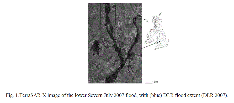
| An ideal data set exists for use in this study. A one-in-150-year flood took place on the lower Severn around Tewkesbury, U.K., in July 2007, which resulted in substantial flooding in urban areas. Flowing in from the northwest, and the Avon, flowing in from the north-east. In a single day, 12 cm of rain fall on the surrounding area. The peak of the flood occurred on July 22, when the level at Tewkesbury was measured at 5.43m Ordnance Data Newlyn , 0.13 m above the previous record from 1947 . Several people were killed, thousands were evacuated from their homes, 50 000 people were without water and electricity for over a week, and about $2.5 billion worth of damage was caused in the region as a whole. In the town of Tewkesbury itself, about 1500 homes were flooded, and floodwater entered Tewkesbury Abbey for the first time in 247 years. The river did not return to bank full until July 31. |
| Fig.1 shows the detail of TerraSAR-X acquired a 3-m resolution Strip-Map image of the region .The TerraSAR-X incidence angle was 24âÃâæ, and the image was multilook ground range spatially enhanced. The HH polarization mode chosen provided good discrimination between flooded and non-flooded regions. At the time of overpass, there was relatively low wind speed and no rain. Aerial photographs of the flooding were acquired on July 24 and 27, and these were used to validate the flood extent extracted from the TerraSAR-X image. Region B covers a larger more rural area along the Severn (with north-south extent 12.3 km, east-west extent 6 km), and the data here were used to validate the TerraSAR-X flood extent in the rural area. Landform Profile DEM generated from 1 : 10000 map contours and having 10-m spatial resolution and 2.5-m height accuracy was used as an example of a lower resolution, less accurate DEM that might be employed in rural areas. |
 |
CONVERSION OF RGB IMAGE TO BINARY IMAGE |
| Before segmentation the satellite image can be converted to binary image. For a binary image, white pixels are normally taken to represent foreground regions, while black pixels denote background. (Note that in some implementations this convention is reversed, and so it is very important to set up input images with the correct polarity for the implementation being used). Then the set of coordinates corresponding to that image is simply the set of twodimensional Euclidean coordinates of all the foreground pixels in the image, with an origin normally taken in one of the corners so that all coordinates have positive elements. |
| For a gray scale image, the intensity value is taken to represent height above a base plane, so that the grayscale image represents a surface in three-dimensional Euclidean space. Then the set of coordinates associated with this image surface is simply the set of three-dimensional Euclidean coordinates of all the points within this surface and also all points below the surface, down to the base plane. Note that even when we are only considering points with integer coordinates, this is a lot of points, so usually algorithms are employed that do not need to consider all the points. |
PROPOSED METHOD |
STEPS IN THE FLOOD DETECTION |
| Steps followed in the flood detection are Segmentation and Classification. |
IMAGE SEGMENTATION |
| Image can be segmented using image segmentation techniques. Some of the image segmentation techniques are, Point, Line, and Edge Detection, Thresholding Segmentation Region-Based Segmentation, Segmentation Using Morphological Image Processing. The context of mathematical morphology as a tool for extracting image components those are useful in the representation and description of region shape, such as boundaries, skeletons, and the convex hull. Two fundamental morphological operations, dilation and erosion, in terms of the union (or intersection) of an image with a translated shape called a structuring element. |
| The most basic morphological operations are dilation and erosion. Dilation adds pixels to the boundaries of objects in an image, while erosion removes pixels on object boundaries. The number of pixels added or removed from the objects in an image depends on the size and shape of the structuring element used to process the image. In the morphological dilation and erosion operations, the state of any given pixel in the output image is determined by applying a rule to the corresponding pixel and its neighbors in the input image. |
| Fundamental Morphological Operations are Erosion, Dilation, Opening, and Closing. Erosion anddilation work by translating the structuring element to various points in the input image and it examining the intersection between the translated kernels coordinates and the input image coordinates. The opening is the erosion followed by dilation. The closing is the dilation, followed by a erosion. |
WORKING OF DILATION |
| The dilation operator takes two pieces of data as inputs. The first is the image which is to be dilated. The second is a (usually small) set of coordinate points known as a structuring element (also known as a kernel). With A and B as sets in Z2 , the dilation of A by B, denoted A⊕B, is defined as |
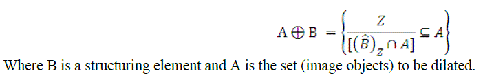 |
| The mathematical definition of dilation for binary images: Suppose that X is the set of Euclidean coordinates corresponding to the input binary image, and that K is the set of coordinates for the structuring element. Let Kx denote the translation of K so that its origin is at x. Then the dilation of X by K is simply the set of all points x such that the intersection of Kx with X is non-empty. |
| WORKING OF EROSION |
| The erosion operator takes two pieces of data as inputs. The first is the image which is to be eroded. The second is a (usually small) set of coordinate points known as a structuring element (also known as a kernel). With A and B as sets in Z2 , the erosion of A by B, denoted AÃÂôB, is defined as |
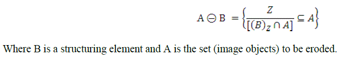 |
| The mathematical definition of erosion for binary images: Suppose that X is the set of Euclidean coordinates corresponding to the input binary image, and that K is the set of coordinates for the structuring element. LetKx denote the translation of K so that its origin is at x. Then the erosion of X by K is simply the set of all points x such that Kxis a subset of X. |
IMAGE CLASSIFICATION |
| The intent of the classification process is to categorize all pixels in a digital image into one of several land cover classes, or "themes". This categorized data may then be used to produce thematic maps of the land cover present in an image. The objective of image classification is to identify and portray, as a unique gray level (or color), the features occurring in an image in terms of the object or type of land cover these features actually represent on the ground. |
| Supervised Classification |
| With supervised classification, we identify examples of the Information classes (i.e., land cover type) of interest in the image. These are called "training sites". The image processing software system is then used to develop a statistical characterization of the reflectance for each information class. This stage is often called "signature analysis" and may involve developing a characterization as simple as the mean or the rage of reflectance on each bands, or as complex as detailed analyses of the mean, variances and covariance over all bands. Once a statistical characterization has been achieved for each information class, the image is then classified by examining the reflectance for each pixel and making a decision about which of the signatures it resembles most. |
| Unsupervised Classification |
| Unsupervised classification is a method which examines a large number of unknown pixels and divides into a number of classed based on natural groupings present in the image values. Unlike supervised classification, unsupervised classification does not require analyst-specified training data. The basic premise is that values within a given cover type should be close together in the measurement space (i.e. have similar gray levels), whereas data in different classes should be comparatively well separated (i.e. have very different gray levels) |
PROPOSED CLASSIFICATION METHOD |
SUPPORT VECTOR MACHINE (SVM) |
| In machine learning, support vector machines (SVMs, also support vector networks) are supervised learning models with associated learning algorithms that analyze data and recognize patterns, used for classification and regression analysis. The basic SVM takes a set of input data and predicts, for each given input, which of two possible classes forms the output, making it a non-probabilistic binary linear classifier. The advantages of support vector machines are high accuracy, nice theoretical guarantees regarding over fitting and with an appropriate kernel they can work well even if you're data isn't linearly separable in the base feature space. Especially popular in text classification problems where very high-dimensional spaces are the norm. |
| Various types of kernels that are used in svm are, linear kernel, Quadratic kernel, RBF kernel (Radial Basis Function), Polynomial kernel, and sigmoid kernel. |
LINEAR KERNEL |
| The Linear kernel is the simplest kernel function. It is given by the inner product <x, y> plus an optional constant c. Kernel algorithms using a linear kernel are often equivalent to their non-kernel counterparts, i.e. KPCA with linear kernel is the same as standard PCA. |
| QUADRATIC KERNEL |
| The Quadratic kernel is less computationally intensive than the Gaussian kernel and can be used as an alternative when using the Gaussian becomes too expensive. |
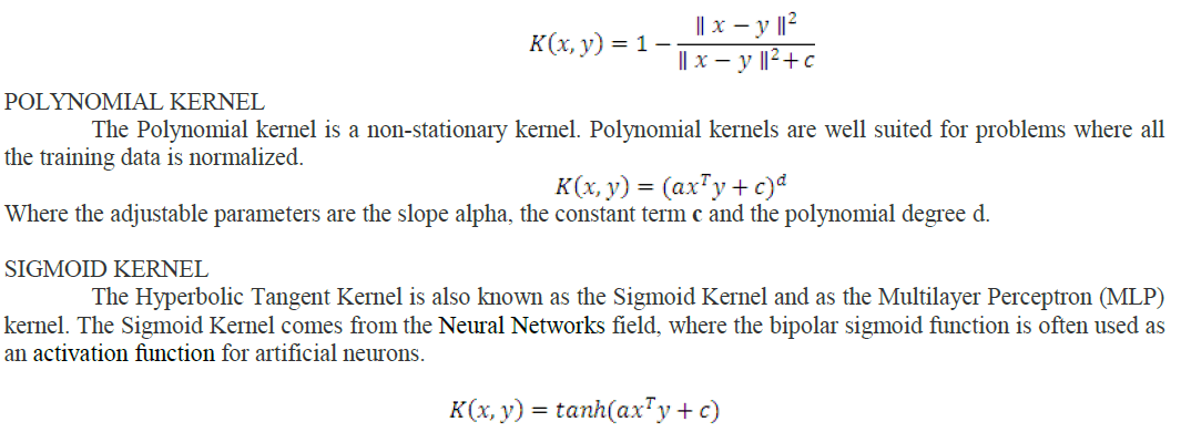 |
| It is interesting to note that a SVM model using a sigmoid kernel function is equivalent to a two-layer, Perceptron Neural network. This kernel was quite popular for support vector machines due to its origin from neural network theory. Also, despite being only conditionally positive definite, it has been found to perform well in practice. There are two adjustable parameters in the sigmoid kernel, the slope alpha and the intercept constant c. A common value for alpha is 1/N, where N is the data dimension |
RESULTS AND DISCUSSION |
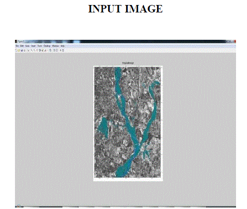 |
| This is the input image that was acquired from the Synthetic Aperture Radar and the image showed that was affected by flood. |
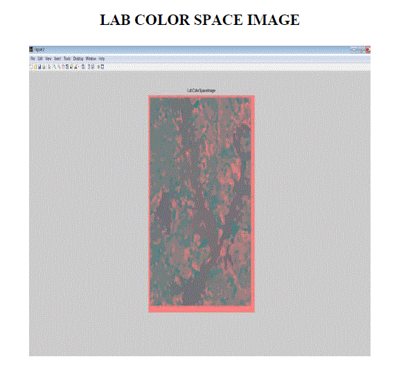 |
| The input image that was acquired from SAR was very difficult in simulation process, so that the input image was converted to lab color space image for easy processing. |
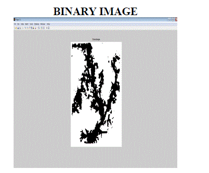 |
| In Matlab, code written of 3D image was difficult, so that the input image was converted to binary image. |
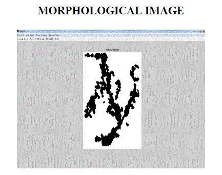 |
| In binary image noises are present. By using morphological segmentation noises are removed and finally it produced a clear morphological image. |
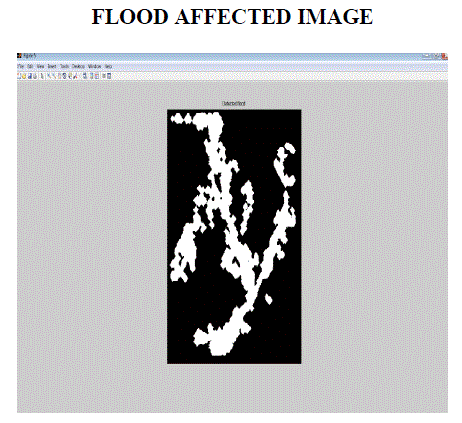 |
| From the morphological image flood affected part can be detected using morphological segmentation. |
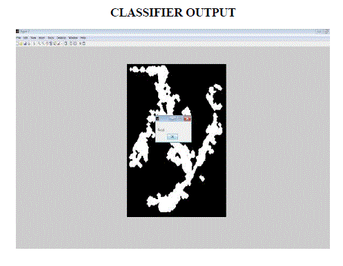 |
| By using SVM classifier flood affected image was classified whether it was flood or drought or normal water level based on threshold value. |
CONCLUSION AND FUTURE WORK |
| An automatic near real-time flood delineation algorithm has been developed that is capable of detecting flood with good accuracy in rural areas, moderate accuracy in urban areas. Because of TerraSAR-X’s poor visibility of the ground surface due to shadow and layover. From the acquired satellite image (input), it converted into binary image because of the affected flood area required. Morphological image processing is used to remove the noise and segmenting an image . From the flood detected image the affected flood area had been detected. A limitation of this work is that it is based on data from a single flood event. Flood detected in the particular area has been achieved. Extend of flooding in both urban and rural areas will be the future work. |
References |
|