ISSN ONLINE(2278-8875) PRINT (2320-3765)
ISSN ONLINE(2278-8875) PRINT (2320-3765)
V. Gopi1 and Lakshmi M.K2
|
| Related article at Pubmed, Scholar Google |
Visit for more related articles at International Journal of Advanced Research in Electrical, Electronics and Instrumentation Engineering
This paper puts into service of network namely ad hoc networks to fetch the speed and position information in real time and gather it in total on every single vehicle to make signal controlling easier at several intersections. We describe precisely the traffic signal controlling problem as job partitioning problem where a job relates to platoons of vehicles. Keeping under consideration of equal size of jobs we make use of an online algorithm to minimize the delay around traffic networks. By using fuzzy logic we can reduce the delay to a greater extent than offline algorithm scheduling where we have a prior knowledge of arrival of vehicles. Here we divide the vehicles into platoons over which we use online fuzzy programming. We represent this as two phase method where platooning acts as phase one and applying fuzzy logic acts as phase two. The simulation outcome illustrates that fuzzy logic gives its best at reducing the traffic delay while comparing with other methods such as vehicle-actuated technique.
Keywords |
| Online job scheduling method, traffic signal controlling technique, conflict graphs, vehicle-actuated method of controlling delay, simulation of vehicular ad hoc networking. |
INTRODUCTION |
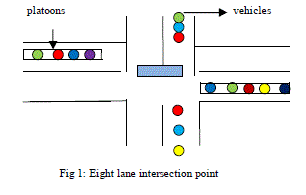
| Traffic signal controlling is nowadays in scope [3]. Now we make use of sensors such as road side sensors namely loop detectors to control the traffic signal [2],[5]. Other techniques include roads equipped with cameras to monitor traffic condition. Actually the drawback of loop detectors is that they can just identify the existence on lacking of vehicles at the intersection point. These detectors connect the traffic signal controller physically and the controller uses this gathered information to schedule the traffic while the vehicle passes through the intersection point. The controller performs scheduling of traffic by cycling of already arranged phases and increasing green time or otherwise avoiding all the phases. After the looping detectors, we use the video cameras to monitor the traffic over roads. The controller collects the data’s regarding traffic using video cameras and adjusts the red light according to that. These are effective with prior knowledge of vehicle arrival and also include human involvement. |
 |
| A. Application of VANET: |
| VANET widely spreads the fine grain vehicle information regarding speed and location of vehicles to traffic signal controller[4]. Using these information we can easily predict the vehicles arrival time at the dead line or stop line of the intersection. This technique seems to be better than the road side sensors who can only predict the presence or absence of vehicles at the intersection. Also installing road side sensors is somewhat difficult than equipping the vehicles with wireless machines[3].The examples of road side sensors include RHODES, and its advance MILOS, SCOOT and SCATS. Both SCOOT[5] and SCATS [6] utilizes loop detectors as sensors but the difference occurs in the placement, one occupies the place at the entry point of every intersection link and the later one occupies the place before the intersection stop line. RHODES and MILOS are making better use of lost times. Using vehicle-actuated method we can estimate the arrival time of upcoming vehicle to reach the stop line. These information’s help the controller to increase the green time so as to make vehicles pass the intersection. All these information’s help to detect the highway road incidents and controlling it[7],[1]. |
RELATED WORK |
| In 2008, B. Hull, R. Newton had proposed a sensor equipped vehicles to detect and report the surface conditions of roads. The pothole patrol system is used to detect the surface conditions. Here we gather data from vibration and GPS sensors and process them to access road surface conditions. The potholes are identified from accelerometer data. It is able to detect the real pothole by aggregating data’s from thousands of taxis. The drawback is that the system is very cost effective. In 2007, V. Gradinescu, C. Gorgorin, R. Diaconescu, V. Cristea, and L. Iftode, proposed data fusion technique in order to provide position information for vehicles that is accurate and robust enough to be applied in VANET critical applications. VANETs advance into critical areas and become more dependent on localization systems, GPS is starting to show some undesired problems such as not always being available or not being robust enough for some applications. For this reason , a number of other localization techniques such as Dead Reckoning, Cellular Localization, and Image /video localization have been used in VANETs to overcome the GPS limitations. Here he made use of loop detectors compute the accurate position of vehicles, creating a new paradigm for localization .These localization techniques can be combined using Data Fusion techniques to provide the robust localization system required by most critical safety applications in VANET. In 2010, Bojin Liu, B. Khorashsdi, Dipak Ghosal, Chen-Nee Chuah, Michael Zhang, proposed a technique of storage capability of VMesh uses a simulation tool that accurately model the freeway vehicular mobility. Random way point mobility model is used. The results that transmission range has high impact on storage lifetime for one way high way traffic. This occurs due to the random vehicle movement in RWP mobility model. In 2011, B. Khorashadi, F. Liu, D. Ghosal, M. Zhang and C. N Chuah, proposed an automated incident detection algorithm for heavy traffic using VGrid vehicles. Each VGrid broadcast beacon messages. The message build and maintain information about different sections of road. They use anomaly detection algorithm based on traffic density. Here voting schemes are used to reduce the robustness. It results in reducing the false rates , zero negative rates and achieves detection at 10%penetration rate. |
MAIN CONTRIBUTION OF THE PAPER |
| Paper relies on OAF algorithm which is an online algorithm dealing with real time speed and position details of each vehicles targeting at reducing the delay at intersection point. Conflict graph indicates details of nearby vehicles and reduces confusion and latency values[8]. Reducing delay is been taken as the degree of effectiveness. The online algorithm processes all vehicles at real time and thus processing each vehicle with details regarding the real time speed and position of vehicles. The online procedure deals with two phase approach. |
| 1) Platooning approach. |
| 2) Fuzzy logic. |
| NS-2 simulation is better at reducing the delay in traffic intersection.We describe the phase one “platooning phase” of OAF algorithm using some terms such as |
| 1) MAX-OUT TIME: Every vehicle is assigning a large amount of green time in the current phase. |
| 2) GAP-OUT TIME: The traffic signal goes to the next phase if and only if the vehicles are gap-out units away from the stop line of traffic intersection. |
| 3) EXTENSION: The traffic signal goes for extension if the vehicles are at a distance about less than gapout time away from the stop line of traffic intersection. |
| A. Description Of System: |
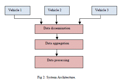
| This paper deals with three phases namely |
| 1) Dissemination phase. |
| 2) Data aggregation phase. Processing phase. |
| In the data dissemination phase, we may collect data from different vehicles and all the data’s are collected by means of some sources such as. |
| Vehicle ID: All vehicles have their own ID number and they are identified by that. |
| Location: The position results from GPS that is placed in the vehicle. Nowadays GPS equipped vehicles are available. |
| Speed: Speed data results from speedometers. Speedometers are already present in old vehicles. |
| Current time: The current time refers to the time at what the vehicles are created. It takes the format of hours, minutes and seconds. All these details are required to differentiate between old and new packets. After dissemination phase we have data aggregation phase where we collect all these details from other vehicles and proceed to processing phase where the traffic controlling is performed using OAF algorithm. The two phases are described below. |
 |
| B. Platooning Algorithm: |
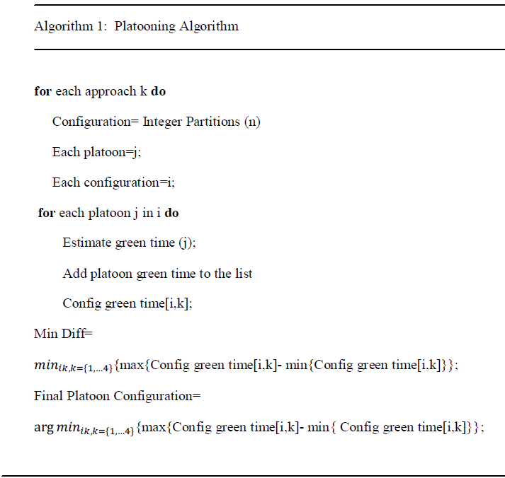
| The paper implies two different phases in controlling the traffic signal at the intersection. The first phase includes platooning method that implies dividing the vehicle into some integers. For instance dividing vehicle in integer number as 2, 3, 3.....,. If the total number of vehicles is 8, then we can divide it into 2, 3 and 3 vehicles per platoon. Then calculating green time for each vehicle in each platoons coming from different directions. After the calculation of green time, differentiate those green times. Next find the difference between the max green times to the minimum green time. There is a process of deciding the platoon size and it is been followed as |
| 1. Select the platoon size in such a way that it minimizes the time required to serve the vehicles. |
| 2. The size of the platoons can be increased for better operation at the intersection point. The green time calculation includes two cases. |
| 3. Case (I): Platoons waiting at stop line |
| Green time = start up time+ time that platoon takes to pass the intersection. |
| Case (II): Platoons reaching the stop line. |
| Green time = time that platoons take to pass the intersection. |
| The time required for a platoon to pass through the intersection is specified as 1.5+h1+...........+hn. |
 |
| C.OJF Algorithm: |
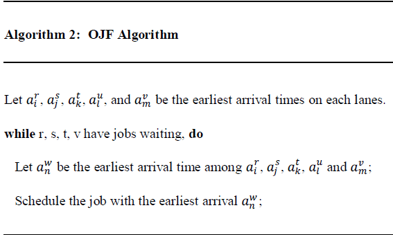
| Job scheduling algorithm depicts a four leg intersection figure that shows some movements. There are chance of some conflicts in activating some movements such as 1 and 2 movement cannot be done simultaneously. In such situations, we make use of conflict graphs which indicates all the movements that consists of conflict threats. With the shortest distance between vehicles in mind, the conflict graph is created to reduce the delay, to reduce the conflicts and increase the efficiency of all vehicles. The beneficial of online algorithm is that it is not dependent on preset speed and location details of vehicles. It does not have any prior knowledge about the arrival of vehicles at the intersection point. At first the upcoming vehicles are grouped into platoons of different sizes and green time is calculated for each vehicle and OJF algorithm is applied to each vehicle. In such an algorithm suppose we may use some vehicles coming from all four directions and some vehicles are waiting already in all the four lanes. The vehicle that reaches the stop line first is taken into consideration and the particular timing of that vehicle is used to schedule the jobs of all other vehicles in the other three directions. |
 |
PROPOSED METHODOLOGY |
| A. Fuzzy logic: |
| Fuzzy based scheduling model is developed by using fuzzy logic. The modelling procedures of fuzzy based scheduling depends on three fuzzy time factors; the numbers of parts already waiting in each machine buffer in terms of sum of processing time, how long it will take to complete the requested operation and the travelling time of part through the route. Therefore the fuzzy variables are named as Work In Queue, Processing time and Distance. These are used for the route selection purpose. The variables of queue are set as SW, MW and LW, indicating short, medium and long work in queue. The fuzzy set of processing time are indexed as SP, MP and LP, indicating short, medium and long processing time. The sets of distance are indexed as ST, MT and LT, indexed as short, medium and long travel time. There are nine distinctive route selection as MN, NL, LO, NA, AV, PA, HI, PH and MX indicating minimum, negative low, low, negative average, average, positive average, high, positive high, and maximum route selection. The route selection criterion takes some rules. They are as follows: |
| 1) If (work in queue is SW) and (processing time is SP) and (distance is ST) then (route selection is MX). |
| 2) If (work in queue is SW) and (processing time is SP) and (distance is MT) then (route selection is MX). |
| 3) If (work in queue is LW) and (processing time is LP) and (distance is LT) then (route selection is MN). |
SIMULATION RESULTS |
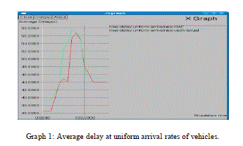
| A graph1implying the average delay experienced by the vehicles when the data sent by vehicles are in uniform manner with very slight difference. Here we compare our proposed OAF algorithm with other method known as vehicle-actuated process. |
 |
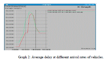
| Graph2 depicts an average delay taken by varying number of nodes. The performance is compared between OAF algorithm and vehicle-actuated method. The current algorithm sends very less delay comparing to later one. Here the data packets are sent in different rates. Therefore packets are in different arrival rates and also OAF method produces less delay in such a condition than vehicle-actuated method. |
 |
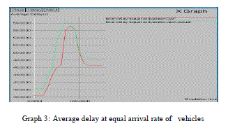
| Graph 3 indicates the comparison of OAF method and vehicle-actuated method’s average delay when data packets are arriving at equal time from different vehicles. The proposed method shows better result in reducing the delay than vehicle-actuated method. |
 |
CONCLUSION |
| In this paper, we saw how a VANET can be used in traffic signal control using an online job scheduling method. All these algorithms make use of fine information’s broadcasts by vehicles coming from different directions. Our experiments comes with a conclusion that fuzzy logic may help in reducing the delay been experienced by the vehicles while passing through the traffic intersection point as compared with other methods such as vehicle-actuated method. It may have some advantages that at low penetration point, it is much successful and during faulty occurrence the scheduling process may get go on and reduce much delay. |
References |
|