ISSN ONLINE(2320-9801) PRINT (2320-9798)
ISSN ONLINE(2320-9801) PRINT (2320-9798)
Kiran V S1/, Savitha Sthawarmath2
|
| Related article at Pubmed, Scholar Google |
Visit for more related articles at International Journal of Innovative Research in Computer and Communication Engineering
This paper proposes a novel way of providing location based-service for check-in application situated to be implemented within smart-phones integrated with the cloud platform and representing a service for cloud end users. The performance of which is independent of employed device, uses a Global positioning system (GPS) and Wi-Fi- Access points in a opportunistic way by considering the scenario of finding the user location. For indoor scenario Wi- Fi Access points are helps in finding the user location by reading the Received Signal Strength (RSS). This is employed where traditional approaches, usually GPS/HPS fails, and aimed to find a user location with room-level resolution. For example Employee check-in in office. While doing this process the cloud will be used as computational resource for collected data from smartphone and the results of it will be stores in the cloud itself, and it made available for the enduser through web application. For outdoor scenario GPS is used for finding location and Google Cloud Messaging Service is used for providing the Messaging service. These information is provided to end-user via web application. The Proposal is, practically implemented over android operating system-based smart-phones along with Cloud Computing Services like Google App Engine and Google Cloud Messaging (GCM) Service. Experimental Results have shown location recognization accuracy of about 90%, opening the door to use as location-based Service.
Keywords |
| Android, Cloud Computing Services, GPS, Wi-Fi Fingerprinting, GCM. |
INTRODUCTION |
| A Location-Based Service (LBS) is an information service, which is dependent on the location of a mobile device, such as smart-phones, palmtops and tablets, these provides the identification of people and objects location. LBS can be used in many applicative scenarios, such as health, object search, entertainment, office work and personal life. LBS applications may also include parcel and vehicle tracking services for time bound critical applications. |
| The motivation for every location based information system is: “To assist with the precise information, at right place in real time with personalized setup and high location sensitivity”. In the electronic era we are dealing with many integrated featured miniature devices which are going to replace the bulky devices, even desktops for computational purposes. We have vast number of applications and usage where a person sitting in a roadside café needs to get relevant data and information. Such needs can only be catered with the help of LBS. We have been able to create a number of different applications where we provide the user with information regarding a place he or she wants to visit. But these applications are limited to desktops only. We need to import them on mobile devices. |
| LBS services can be categorized as triggered LBS services (push services) and user-requested LBS services (pull services) [1]. In a triggered (push) LBS service, the location of user's mobile device is retrieved when a condition set in advance is fulfilled. In a user-requested (pull) LBS service, the user decides whether and when to retrieve the location of his/her mobile device and use it in the service. |
| The success of Cloud Computing (CC) offers added opportunities for LBSs, which can be exploited in the Cloud and give origin to cloud-based LBSs. CC paradigm is clearly defined in [2]. The cloud model is composed of: 1) five essential characteristics: on-demand self-service, broad network access, resource pooling, rapid elasticity, and measured service; 2) three service models: Software as a Service (SaaS), Platform as a Service (PaaS), and Infrastructure as a Service (IaaS); 3) four deployment models: private clouds, community cloud, public cloud, and hybrid cloud. The detail of service models is important to evidence the exploitation of LBS through the Cloud. From [1]: SaaS represents the capability provided to the consumer to use the provider’s applications running on a cloud infrastructure. The applications are accessible from various client devices through client interfaces, such as web browsers and/or program interfaces. PaaS focuses on the capability provided to the consumer to deploy onto the cloud infrastructure consumer-created or acquired applications developed by using programming tools supported by the provider. IaaS evidences the capability provided to the consumer concerning processing, storage, networks, and other computing resources where the consumer is able to deploy and run arbitrary software, which can include operating systems and applications. Another model, detailed in [3], is important to mention: Data as a Service (DaaS), which focuses on the capability provided to the consumer to access shared data in the Cloud. |
| The full and efficient utilization of our LBS, in particular is strictly connected with the evolution of Cloud Computing, Smartphones, GPS/HPS, Wi-Fi access points, Cloud Platform and Infrastructure and are tools used by LBS applications. |
II. RELATED WORK |
| In recent years, many indoor and outdoor location recognition methods have been developed. For indoor environments, infrared, ultrasonic, GSM, Wi-Fi and RFID are commonly used technologies while, in case of outdoor scenarios, GPS and Cell Tower Localization are the most employed [4], although Wi-Fi is used [5] at metropolitan-scale.GPS is the most popular and widely used positioning system, it is maintained by the United States government and provides location information obtained by signals sent from a group of satellites. GPS can provide users locations very accurately but its signals are often blocked and absorbed by walls or other obstacles [6]. Therefore GPS is suitable for outdoor environments. Rosum’s TV-GPS is an enhanced positioning technique, which works both indoor and outdoor. It uses the Time Difference Of Arrival (TDOA) approach applied to TV signals to estimate the position. As said in [4], it needs additional hardware for television transmitter towers to achieve precise time synchronization. The achieved positioning error is in the range 3.2–23.3 [m]. Another interesting localization approach is Japan’s Indoor Messaging System (IMES), which is an important part of the regional Quasi-Zenith Satellite System (QZSS) project. It uses GPS signals and provides precise positioning because it employs terrestrial transmitter equipments and beacons to assist the whole localization process [7]. |
| All the above mentioned localization systems are not suitable for smart-phone platforms integrated with the Cloud, which is the reference technological environment of this paper. The motivation is linked to two main factors: i) the high cost of the network infrastructure for metropolitan-scale coverage; ii) the necessity of additional modules for mobile devices, which increases Smartphone implementation costs. In the recent past, the need of localization techniques that provides good user position without requiring extra-hardware and high costs, and so that can be efficiently implemented over smart-phones by using GPS for outdoor and Wi-Fi [8] fingerprinting for the indoor location recognization are prominent. |
| Wi-Fi fingerprinting is a localization technique used for positioning with wireless access points is based on measuring the intensity of the Received Signal Strength. The accuracy depends on the number of the positions that we entered into database and the possible signal fluctuations that may occur can increase errors and inaccuracies. |
III. SYSTEM DESIGN |
| A positioning component is usually needed in a LBS application to determine the location of user's mobile device. We can refer these user locations in a two context based on where the user is presence like... When we need to find a location of user present in the Building we can call it has Indoor Location Recognization (ILR) and for outside scenario we refer that has Outside Location Recognization(OLR). |
A. Indoor Location recognization |
| Indoor Location recognization (ILR) is a network of device used to locate objects or people inside a building wirelessly. Instead of using satellites, an ILR relies on nearby anchors (nodes/wifi access point with a known position) and applies the Wi-Fi fingerprinting technique. There are two stages to carry out the Indoor Location Recognization technique. |
| a) Training mode |
| b) Location-identification mode |
Architecture |
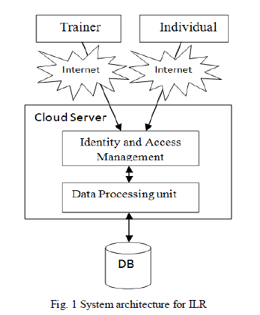
| Fig.1 shows the system architecture of indoor location recognization, The architecture mainly consists of smart-phone based API system (like Android device), cloud data Store and a internet interface. |
| By using the smart-phone-based API system, it is possible to obtain the required wi-fi scanned values from the Wi-Fi enabled android device and at the mean time scanned values will be sent to the cloud. On cloud side we need to implement algorithm such that It should store the trained values of Wi-Fi scanned results and able to compare the incoming values with the trained values during prediction mode to identify the location. |
 |
| Step1: Training Mode |
| This is the initial step of indoor location recognization performed only once. Before starting the trainer mode we need a prerequisite like Internet enabled Android smart-phone and at any point within Building the smart-phone should able to scan the minimum 4 access points RSSI values in-order to get the more accuracy in finding the location. |
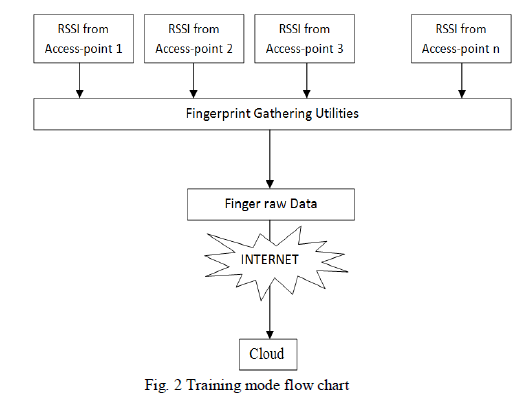 |
| Fig. 2 shows the training mode flow chart, in training mode the trainer first scan for the available number access points in particular location. If he can’t able to find the enough access points then scanning is failed for that particular location then you should changed to other location where smart-phone can able to find the enough access points, once you get the enough access points, read the RSSI values of those access points, while reading you have to take 360 degree rotation because RSSI values may vary for same location when we stand in different directions then we need to take the average RSSI value for that location along with SSID/BSSID of access points and send it to the cloud using internet. |
| Step 2 Location-Identification Mode |
| In these we are actually finding a location using the trained data and current Data. The Trained Data is the one which is uploaded by the trainer to the cloud, the current data could be the RSSI value from the user, both of these will be used in Nearest Neighbour Algorithm to find a user location. |
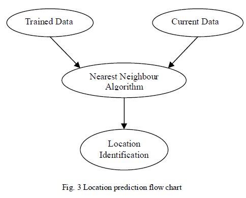 |
| Fig. 3 shows Location prediction flow chart, the nearest neighbour algorithm provides the idea of deterministic WLAN based positioning. , the current received signal strength is compared with the trained values in the database (cloud). The record that matches the current received signal strength best is picked up. The idea is to calculate the Euclidean distance between the current received signal strength and the records in the database (cloud) and choose the one minimizing the Euclidean distance. |
| Euclidean distance (Sm, Si) = (SSm0 - SSi0)2 + (SSm1 - SSi1)2 + ... + (SSmn-1 - SSin-1)2. |
| Assume Sm = {SSm0, SSm1, ..., SSmn-1} is the tuple of current received signal strength. Assume Si = {SSi0, SSi1, ... SSin-1} is the tuple of signal strength value of a trained/calibrated location. SSm0, SSi0 are signal strength from AP0, SSm1, SSi1 are signal strength from AP1, and so on. |
B. outdoor location recognization |
| In outdoor location recognization we are trying to fetch the location of user outside the building by using GPS service. Here we are developing an android app that uses GCM service. A GCM [9] implementation includes a Googleprovided connection server, a 3rd-party app server that interacts with the connection server, and a GCM-enabled client app running on an Android device: |
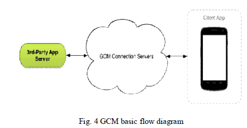 |
| GCM basic flow diagram is shown in Fig. 4. This is how these components interact: Google-provided GCM Connection Servers take messages from a 3rd-party application server and send these messages to a GCM-enabled Android application (the "client app") running on a device. |
| The 3rd-Party Application Server is a component that you implement to work with your chosen GCM connection server(s). App servers send messages to a GCM connection server; the connection server en-queues and stores the message and then sends it to the device when the device is online. The Client App is a GCM-enabled Android application running on a device. To receive GCM messages, this app must register with GCM and get a registration ID. |
RESULTS |
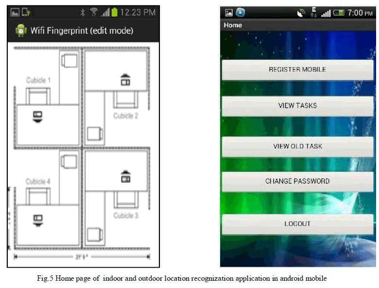
| In this section, results are presented and discussed for the indoor and outdoor location recognization. Fig. 5 shows the indoor and outdoor recognization home page in android mobile. In indoor location recognization a office/floor is divided in to four cubes with enough Wi-Fi access points which is required to carry out the Wi-Fi fingerprinting, their RSSI values will be used in training and during location identification. To evaluate the performance of the ILR employee scenario is considered, at user/Employee side has to login with his employee id and password then for a successive time interval it will send the RSSI values needed for the computation, by using these we can predict the employee location within a office, and save it as an info in the cloud for manager/admin/supervisor purpose as server side app which is deployed in cloud. |
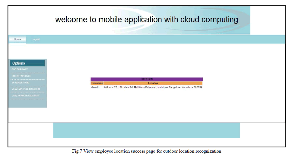
| For evaluating the performance of OLR we are taking the marketing domain employees so that at user side we have registered mobile, view tasks, view old tasks, send acknowledgement, and change password options. At server side the admin/Manager can add/delete employee, schedule task, view employee location and acknowledgement |
 |
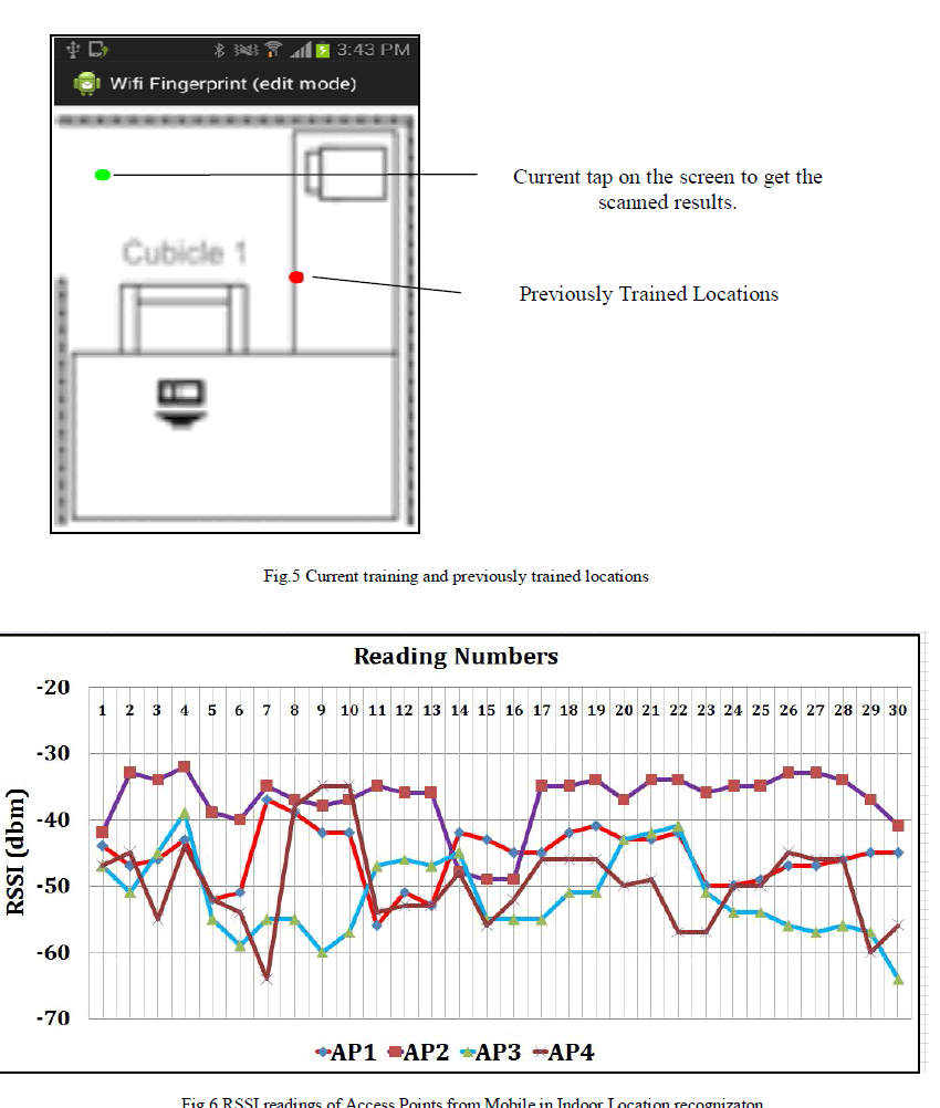 |
| Fig 5 shows scanning and sending of the RSSI values during the training mode, at fixed interval of time. RSSI values were collected from four Wi-Fi Access Points (AP) sequentially and plotted as shown in Fig 6. Fig 7 shows the marketing employees location identification for the outdoor recognizaton |
 |
V. CONCLUSION |
| In near future all the mobile devices will have internet access. This way it is possible to develop mobile applications that can take advantage of both internet and cloud computing. The main contributions of this paper is making use of google cloud infrastructure to deploy server application and manage android application users through it for Indoor and outdoor location recognization using WiFi finger printing and GPS. The application provides features like locating employees indoor and outdoor, scheduling task, viewing employee response etc. which are day to day activities, automation of the same eases once life. |
References |
|