International Journal of Advanced Research in Electrical, Electronics and Instrumentation Engineering
ISSN ONLINE(2278-8875) PRINT (2320-3765)
ISSN ONLINE(2278-8875) PRINT (2320-3765)
M.Alzoubi1, A.MaungThan Oo2, A.Stojcevski3
|
| Related article at Pubmed, Scholar Google |
Visit for more related articles at International Journal of Advanced Research in Electrical, Electronics and Instrumentation Engineering
The McArthur Forest Fire Danger Indices (FFDI) have been used in Australia since was developed in 1960s and used by fire authority to measure the level of fire danger. Its value depend on the drought factor which is based on dryness of the fuel and other weather variable factors such as temperature, relative humidity, rainfall, wind speed and wind directions. The accuracy measurement of FFDI output depends on the accuracy of the input variables, inaccuracy and uncertainty of these inputs may result in incorrect of the FFDI value. As the value of the FFDI increased the more effected from the inaccuracy of the wind speed, temperature and humidity. Bushfires prediction systems sensitivity depends on the instruments accuracy used to measure the input data.
Keywords |
| FFDI, accuracy, uncertainty, bushfires, weather variables.. |
INTRODUCTION |
| Around the globe there are a significant research activities concerning early warning and evacuation systems in case of bushfires hazard. FDR system is one of the most important tools for early warning systems. Examples of fire danger indices include those employed in eastern Australia by McArthur in1960s[1], Gill et al. in1987 [2]and Cheney and Sullivan, 1997[3]. And those employed in Western Australia by Sneeuwjagt and Peet, 1985[4]. However there are no such investigations or research activities highlights the influence of instrument accuracy used to measure the input parameters of the FFDI system. Hence this paper will investigate and analyse the influence of the instrument uncertainty of the FFDI system. |
| Bushfires are frequent events in Australia. They are a combination of metrological, physical, social and biological process. Dry weather, wind and high temperature usually are associated with bushfires. Bushfires can be caused naturally or by human. Lightning strikes which generated from thunderstorm cause most of bushfires done naturally, while human activities responsible for bushfires on public land, Some example of human causes of bushfire, campfires when people leave campfires not fully or agricultural burns when farmers burn vegetation on their farms or from Equipment or machinery that generates heat or deliberately. Bushfires have become a major environmental issue in southeast of Australia[5][6][7]. However, the impact of bushfires should not be considered only as an issue of environmental disaster like air pollution, destruction of water resources and droughts but also they should be perceived as a matter of social and economic problems. Protecting individuals, societies and properties are the main concerns to the government authorities and agencies as bushfires become repeatable phenomena in Australia[6][8][9]. |
| Metrological data include temperature, wind speed and direction; atmosphere pressure; rainfall and relative humidity play a crucial role for predicting the potential of bushfire to occur, fire dangers and the way of fire behave particularly wind speed and temperature. They have a direct and indirect impact on the fire ability to expand. Accurate metrological data forecasts have potential for good planning to allocate resources and volunteers members to respond to the bushfires [10][11][12][5]. |
| Bushfires is a common feature in Australian and accurate prediction of forest fire danger is essential to predict potential fire and control the fire when it happened. McArthur Forest Fire Danger is widely used in Australia to predict fire danger[13][14]. Fire danger index is defined as a resultant of both variables and constants fire danger factors which influence the start of fire, rate of spread and the difficulty of manage and control of the bushfire. The integration of these elements can be converted into one or more numerical index. This index called fire danger index which is depends on four main elements, drought factor, relative humidity, temperature and wind speed[15][16]. Accurate data of weather elements are very important to get accurate assessment of fire danger level and to successful bushfires operations. |
| The accuracy of weather data can make efforts to control bushfire and smoke successfully. In addition its very useful tools to predict the fire danger, small error in weather data such as small error or uncertainty in wind speed reading can lead to wrong assessment in fire danger index [17][18][19]. |
| The degree of accuracy in bushfires occurrence prediction systems is dependent on the systems applicability to a given situation, the validity of the system relationships, and the reliability of the system input data. |
II.FOREST FIRE DANGER RATING PREDICTION SYSTEMS AND INDICES |
| The first fire danger system was installed in Australia in 1960s. The main purpose of the system was to protect people and their properties from the hazard of fire spreading. It has the ability to warn people from the danger of bushfire through agencies and government authorities which can reduce live losses and properties damage. In Australia, fire danger is determined using McArthur's forest and grassland fire danger metres. McArthur fire danger index or meter is the most widely index used in Australia, its statistical based system. The occurrence of the bushfires depends on wind speed, temperature, relative humidity, fuel and the amount of moisture in the fuel. Weather variables and type of the fuel play a crucial role on this system[20][21][22]. |
| Fire danger rating systems are used to assess the potential for bushfire occurrence, fire spread and difficulty of fire suppression. Typically, fire danger rating systems combine meteorological information with estimates of the moisture content of the fuel to produce a fire danger index. |
| When bushfires occurred and developed it’s depend on many factors. These factors interact together to create the fires the main factors that affect fire ignition are weather parameters, environmental factors and the nature of the fuel, some of these factors are variables such as wind speed, temperature, humidity, degree of curing ….etc. while constant factors such as slop of the land. Many methods developed to convert the weather and fuel factors into fire danger index, this index show the level of fire danger that may threaten to the people [22][23][10] . |
| There’s many factors affecting the fire danger index wind speed is considered one of the main important factors that affecting the fire occurrences and it’s considered the most important factor that determine the direction and the rate of spread of the bushfires because its provide the fire oxygen and push the flames fire towards unburnt fuel. In addition, Fuel and weather condition are main factors in bushfires. |
| Bushfires occurs from a complicated chemical and physical process. This process is depending on three main factors which are weather parameters which is highly variable over the time, topography and fuel (vegetation). In addition, these factors have great influence on the bushfires behaviour and directions [10][24][6]. |
| Weather: |
| ïÃâ÷ Air temperature |
| ïÃâ÷ Wind |
| ïÃâ÷ Relative humidity |
| ïÃâ÷ Precipitation |
| ïÃâ÷ Air stability |
| Topography: |
| ïÃâ÷ Inclination of slope |
| ïÃâ÷ Direction of slope |
| ïÃâ÷ Ravines |
| Fuel: |
| ïÃâ÷ Moisture content |
| ïÃâ÷ Size and character of fuel (compact or grinded fuel) |
| ïÃâ÷ Heat content |
| ïÃâ÷ Amount of fuel |
| ïÃâ÷ Continuity of fuel |
| ïÃâ÷ Type of fuel |
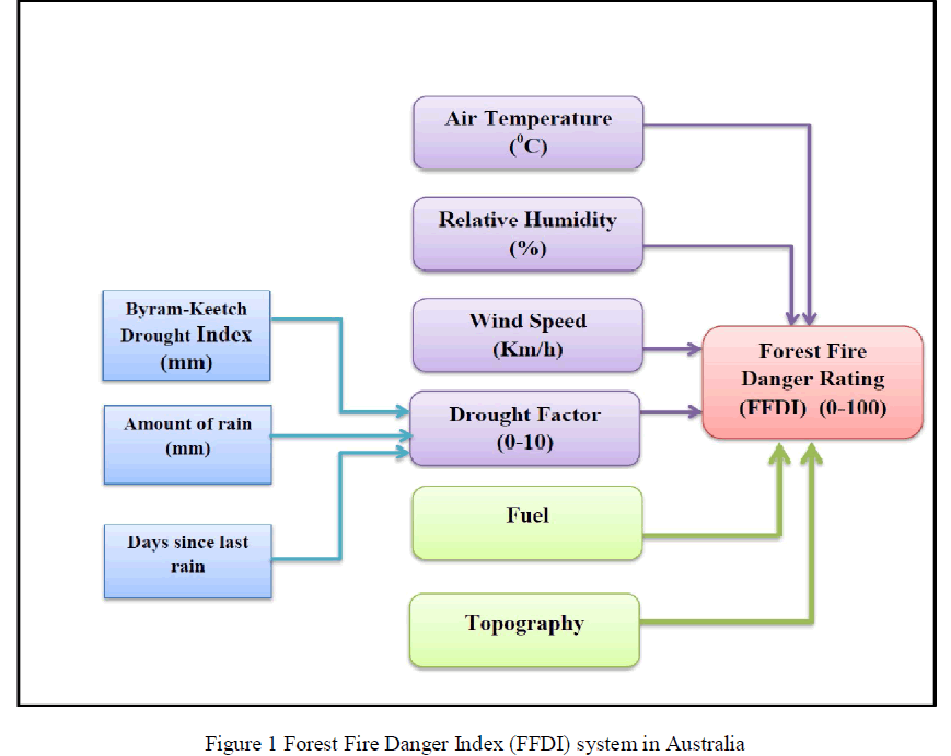
| The three weather variables needed to calculate the forest fire danger index are temperature, relative humidity, and wind speed. These variables influence the ease with which fires can be started. While the rain influence the drought factor and the atmospheric pressure has indirect influence on the wind speed and direction [24][14][6]. Figure 1 show the FFDI system in Australia. |
 |
III.FIRE DANGER INDEX |
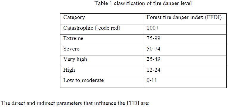
| The Fire Danger Rating (FDR) is an assessment of the potential bushfire behavior and it used to provide a measure of the bushfire condition, threat and the potential impact on the community and environment should a bushfire occur on a given day [25][13].Since black Saturday in Victoria in 2009, a standardized fire danger rating (FDR) was adopted in all states of Australia. Its mission is to provide fire weather forecasts including temperature, wind speed and direction, relative humidity and dryness of vegetation during the fire season to bushfire agencies and authorities to determine the appropriate Fire Danger Rating table 2 shows the classification of fire danger rating and the potential fire behavior [11][9][26][12]. |
| The Forest Fire Danger Index (FFDI) is the main tool to determine the fire danger rating in Australia and can be calculated from the following equation [32]: |
| Where T is the temperature (Ãâ¹ÃÅ¡C), U is the wind speed (km h-1), RH is the relative humidity (%) and DF is the Drought Factor. |
| The FFDI is the base for the fire danger classification scheme used in Victoria in Australia, where fire danger level are classified as low, moderate, high, very high, severe, extreme or catastrophic according to the value of the FFDI as shown in table 1. |
 |
1. DROUGHT FACTOR |
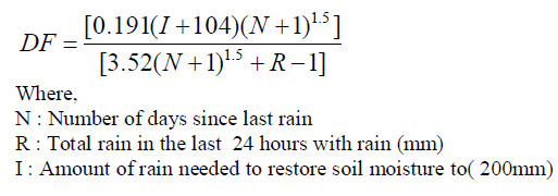
| Drought factor is a measure of fuel availability or a condition of dryness in the duff and upper soil layers that progress from total moisture saturation to an absence of available moisture (fuel dryness) [27][5][10]. It’s an empirical of the estimate of the fuel moisture content (the amount of dry fuel available for burning) which is dependent on three factors, the first factor depend on the recent significant rainfall through direct wetting by rain and the second factor depend on the days since last rain and the third factor depend on the wetting from below via soil moisture which can be calculated using KeetchByram Drought Index (KBDI) which is defined as the total rain in the most recent 24 hours with rain and the amount of rain needed to restore soil moisture to 200mm. KBDI is a soil drought index with value ranges from 0 to 800and is based on the soil capacity in 200 mm of water. The depth of soil required to hold 200m of moisture varies. A prolonged drought (high KBDI) influences fire intensity largely because fuels have lower moisture content[28][20][29].Drought factor value range from 0 – 10, with zero value of DF the potential of fire is very low due to the fuel is fully of moisture as the value of DF increases the potential of fire increase. With DF value of 10 it indicate that the fuel is very dry and has no moisture and the potential of fire is very high. |
| The Drought factor is a measure of moisture in the fuel which is affected by rains and number of days since last rain. Drought factor can be calculated from the following equation: |
 |
2. FUEL |
| Dry Fuel or the moister percentage in the fuel is an important factor that affecting the bushfire potential .The fuel moister content depends on the number of dry days, the more dry days the fuel becomes ready to ignite quickly. In addition, atmospheric pressure, temperature and relative humidity are important factors to control the bushfire. Thus, the relation between the fire dangers is directly proportional to the wind speed and inversely with fuel moisture content [10][24][14][6]. |
| When fuel load is big the fire will be hotter and the rate of burning is more. When fuel is concentrated with adequate spacing it will burn faster than heavily compacted. Smaller pieces of fuel such as branches, leaves and twigs burn quickly, particularly when they are dry and loosely arranged. Some types of grasses burn very rapidly, while larger fuels, such as tree trunks, do not burn as easily [24][22][30][31]. |
| Fuel moisture content (FMC) is a measure of the amount of moisture (water) in the fuel.Fuel moisture content or index is the moisture weight of a fuel and it’s calculated as a percentage. For example, if a kilogram fuel sample is dried and weighs 700g, then the fuel moisture content is 43%. Another example, if a kilogram fuel sample is dried and weighs 800g, then the fuel moisture content is 25%. |
3. TOPOGRAPHY |
| Areas topographic features can play an important role in influencing bushfire behaviour and direction. These topographic factors include slope steepness, aspect, elevation and configuration of the land. Variations in these can cause dramatic changes in bushfire behaviour[5][32]. |
4. WEATHER PARAMETERS AND ACCURACY OF MEASUREMENT |
| Accuracy, precision and uncertainty are used in connection with fire weather measurements and danger rating levels. The accuracy of a measurement is related to the equipment used in the field or the technique of measurement. The accuracy of measurements is the degree of closeness of measurements of a quantity to the actual value. The precision of a measurement equipment usually related to the repeatabilityand it’s related to the degree of repeated measurements under unchanged conditions [25][18] . |
| A measurement of equipment can be accurate but not precise, precise but not accurate, neither, or both. For example, if an experimental result contains a systematic error then increasing the sample size will increase precision but does not improve accuracy. On the other side, reduce or eliminate the systematic error will improve the accuracy but not change precision. When the equipment having an accuracy of ± 1 units. It means that a series of measurements of some constant property made with the instrument were mostly (99% of the time) within one unit of the correct value [18][33][34]. |
| FDI daily calculations for a specific area will result in an estimate of fire potential for that area at that time. Because the FDI System is designed entirely as a function of weather parameters, forecast FDI values can be calculated from the forecast values of the necessary weather parameters [21][13]. |
| The main problem in calculating the FDI is the difficulty in forecasting the wind parameter. To the FDI calculations are very sensitive wind speed parameters small variation in wind speed will increase the value of the FDI depending on the drought factor value. Nowadays sensors are used widely to measure the metrological variables and sensors having different accuracy measurement depending on the manufacturer and maintenance. A sensor is a converter device that detects and responds to some type of input from the physical environment such as temperature, light, humidity, heat, motion, wind speed, moisture, pressure, or anything related to the environmental phenomena. The output is generally a signal that is converted to human readable display at the sensor location or transmitted electronically over a network for reading or further processing [35][36]. |
TEMPERATURE (oC) |
| A temperature is a numerical measure of hot or cold. It’s measured in degrees and is the heat of the air mass. The Celsius scale (°C) is used for common temperature measurements in most of the world many instruments are available in the market for temperature measurements its accuracy vary and depend on the manufacturers. Temperature has direct effect on the bushfires behaviour. High temperature is responsible to increase the temperature of grass and forest fuels to their ignition points. In addition temperature affects the atmospheric stability and wind speed. Fuel temperature affects directly bushfires behaviours and rate of spread [9][6][37]. |
| The accuracy of temperature equipment is greatly dependent on the manufacturer, but also can be affected by usage. The accuracy of temperature can affect the value of fire danger index. |
RELATIVE HUMIDITY (RH) |
| Relative humidity is the amount of water vapour in the air and it is measured as a percentage. The amount of the moisture in the atmosphere will affect the amount of moisture in the grass and forest fuel. When humidity is high bushfires will not spread because the grass and forest fuel contain have a high amount of moisture. On the contrary when the humidity is low the grass and fuel moisture levels will be low. In this case bushfires will spread very quickly. Relative humidity varies during the 24 hours, it’s in lowest rate in the afternoon period and in the highest rate in the night and early morning this is due to relative humidity is affected directly from temperature [12][11][6]. |
| Several instruments or equipment’s are readily available and affordable for relative humidity measurements. These equipment’s `may provide accurate (plus or minus 2 to 5%) relative humidity readings depending on environmental factors such as dust, moisture, fog, and gaseous contaminants can affect the sensors. |
WIND |
| Wind speed is the rate of the movement of wind in distance per unit of time. it can be affected by terrain and obstacles such as buildings or trees. Cup-anemometer has been used to sense wind speed. An anemometer is useful because it rotates with the wind. The cup anemometer usually consists of three conical or spherical cups mounted on a rotating shaft. The speed of rotation is proportional to wind speed [12][38][39]. |
| Accuracy of the wind speed depends on proper maintenance of the cups, recorder and the power supply. The range of the wind speed is within 5% of the total measurement in normal conditions. |
| Wind is the most important factor affecting the bushfires behaviours due to the fanning effect on the fires; wind can change direction and intensity which means more burning and more damage. Wind is very important in bushfires for the following reasons: |
| ïÃâ÷ Its supply oxygen for the combustion process which make the fuel burning more rapidly. |
| ïÃâ÷ Reduce the grass and forest moisture which increase the drying of the fuel |
| ïÃâ÷ Move the fires and heat toward the forest fuel in the path of fire. |
| The main two elements of wind effect are direction and speed. These elements are usually associated with high to extreme fire. Wind can change speed, direction or it can be stormy. Strong and high wind will make the fire move faster and faster[6][12][40] . |
WIND DIRECTION |
| Wind direction is defined as the direction, which the wind is blowing from. A wind vane is also called a weather vane; it is a tool for measuring wind direction. For example, a westerly wind blows from the west to the east and northerly wind blows from the north to the south. Wind direction is usually reported in cardinal directions . For example, a wind coming from the south is given as 180 degrees; one from the east is 90 degrees. The accuracy of the wind direction instruments is within one degree in normal condition [34][10]. |
ATMOSPHERE PRESSURE |
| Atmosphere stability is important in bushfires it’s the resistance of the atmosphere to vertical motion. Instability of the atmosphere will result in vertical movement in the air leading to increase the bushfires activities. The more difference in temperature resulting from bushfires in the atmosphere will create unstable conditions and then air move in both directions vertically and horizontally [10][24]. |
RAINFALL |
| Rain has a direct effect on humidity and fuel moisture, when rain fall temperature drops down and wind become calm. Rainfall will dampen the surface of the grass and forest fuel to the stage that fires can’t ignite the fuel. The amount of the rainfall has direct effect on the drought factor value [34][24][10]. |
IV.RESULT AND DISCUSSION |
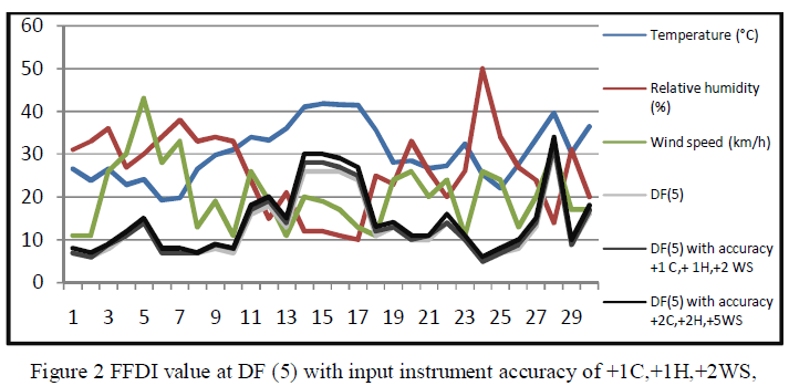
| In this section weather data from Australia Government Bureau of metrology was collected for two locations the first location is from Kinglake area (Kilmore gap station) and the second location is Bendigo for January 2014 where the potential of bushfires is very high. In addition, we propose a set of different value of temperature and wind speed with constant low relative humidity and analyse the relationship between these variable data and the FFDI and how the accuracy of the weather variables sensors and devices can affect the value of FFDI. In our analysis we propose different value of drought factor (DF) with value of 5, 7 and 9. |
 |
| +2C,+2H,+5WS for Bendigo |
| The data for temperature, relative humidity and wind speed were collected and analysed for Bendigo area as shown in figure 2 which is show also the relationship between main weather variables (temperature, relative humidity and wind speed) and FFDI value at drought factor value of (5) with two proposed different accuracy for input sensors for weather variables.For temperature sensors (with accuracy of +/- 1C in the first case and +/- 2C in the second case) , for humidity sensor (with accuracy of +/- 1 RH in the first case and +/- 2 RH in the second case) and for wind speed sensor (with accuracy of +/- 2 WS in the first case and +/- 5C in the second case). The results show there is a small changes in FFDI value at DF (5). |
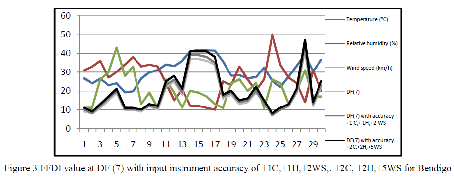 |
| The same procedure applied for Bendigo area as shown in figure 3 with the same set of input instruments accuracy ts, but with drought factor value of (7). The results show that as there is increase in FFDI value at drought factor value (7). |
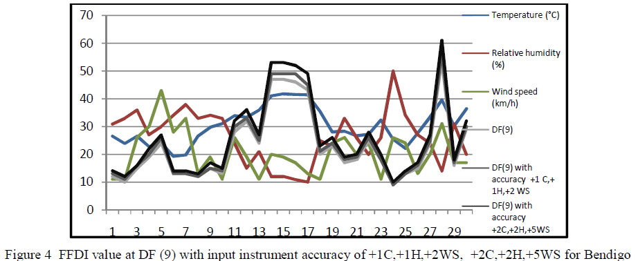 |
| In figure 4 we applied drought factor value(9) on the same area (Bendigo), For temperature sensors (with accuracy of +/- 1C in the first case and +/- 2C in the second case) , for humidity sensor (with accuracy of +/- 1 RH in the first case and +/- 2 RH in the second case) and for wind speed sensor (with accuracy of +/- 2 WS in the first case and +/- 5C in the second case). The results show that as there is increase in FFDI value at drought factor value (9). |
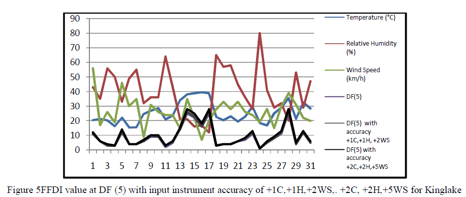 |
| In figure 5 we select different area which is Kinglake Area(Kilmore gap station). The data for temperature, relative humidity and wind speed were collected and analysed for this area. The relationship between main weather variables (temperature, relative humidity and wind speed) and FFDI value at drought factor value of (5) were analysed with two proposed different accuracy for input sensors for weather variables.For temperature sensors (with accuracy of +/- 1C in the first case and +/- 2C in the second case) , for humidity sensor (with accuracy of +/- 1 RH in the first case and +/- 2 RH in the second case) and for wind speed sensor (with accuracy of +/- 2 WS in the first case and +/- 5C in the second case). The results show there is a small change in FFDI value at drought factor (5). Drought factor has a significant effect on the calculation of FFDI value, as the drought factors increase the FFDI value will increase. |
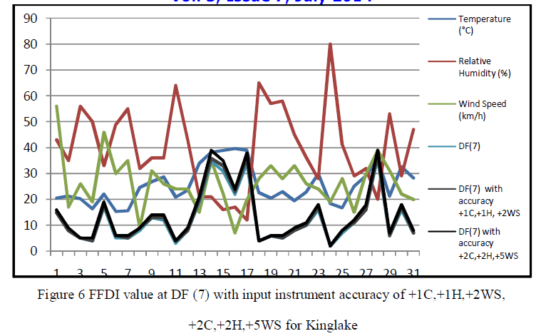 |
| Drought factor value of (7) was applied on kinglake area as show in figure 6 with the same proposed inputs accuracy. The results show that the FFDI value increased at drought factor (7). |
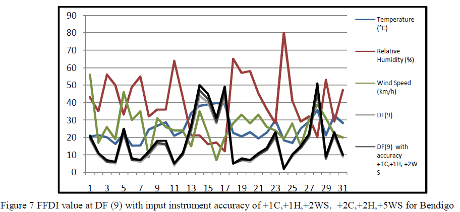 |
| In figure 7 we applied drought factor value(9) on the same area (kinglake area), For temperature sensors (with accuracy of +/- 1C in the first case and +/- 2C in the second case) , for humidity sensor (with accuracy of +/- 1 RH in the first case and +/- 2 RH in the second case) and for wind speed sensor (with accuracy of +/- 2 WS in the first case and +/- 5C in the second case). The results show that as there is a significant increase in FFDI value at drought factor value (9). |
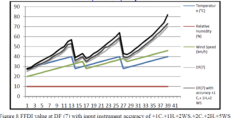 |
| In figure 8 we propose different sets of (temperatures, humidity and wind speed)then we applied drought factor value(7).For temperature sensors (with accuracy of +/- 1C in the first case and +/- 2C in the second case) , for humidity sensor (with accuracy of +/- 1 RH in the first case and +/- 2 RH in the second case) and for wind speed sensor (with accuracy of +/- 2 WS in the first case and +/- 5C in the second case). The results show that there is increase in FFDI value at drought factor value (7). |
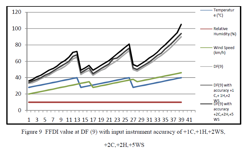 |
| In figure 9 we applied the same sets of input accuracy at drought factor (9).The results show that there is a significant increase in FFDI value at drought factor value (9). Its concluded that as the drought factor increase, it will affect the FFDI value increase significantly with the same sets of instruments accuracy. |
V.CONCLUSION |
| The FFDI is very sensitive to the weather variables such as wind speed, temperature and humidity. Variations in wind speed will result in significant variation in FFDI value. Temperature is the second influence variable on the FFDI value. The last weather variable the affect the FDI value is the relative humidity with low value of humidity will increase the FFDI value. Inaccuracy of the measuring instrumentation can increase the average uncertainty of the FFDI value up to 17 % depending on the real value of FFDI. Inaccuracy of instrumentation can lead to uncertainty of calculated of FFDI which can result in wrong information about fire danger level. |
References |
|