International Journal of Advanced Research in Electrical, Electronics and Instrumentation Engineering
ISSN ONLINE(2278-8875) PRINT (2320-3765)
ISSN ONLINE(2278-8875) PRINT (2320-3765)
Krishna Kant Singh1, Neelima Saini2, Nitin Garg2, Sunita Mandal2, Nitigya Grover2
|
| Related article at Pubmed, Scholar Google |
Visit for more related articles at International Journal of Advanced Research in Electrical, Electronics and Instrumentation Engineering
This paper presents an unsupervised change detection method for satellite images based on normalized neighborhood Gustafson Kessel Clustering. The method works in two phases in the first phase a difference image is created from the two bi temporal satellite images using normalized neighborhood ratio. The difference image is then clustered into two clusters change and unchanged using Gustafson Kessel Clustering to create the change map. In the change map the changed areas are highlighted. The method is applied on bi-temporal images of Reno lake Tahoe area and the results obtained from the proposed method are compared with some other state of the art methods. The quantative as well as qualitative comparison of the results show that the proposed method gives much more accurate results than the other existing methods.
Keywords |
| Change detection ,GuftasonKessel Clustering , Clustering , Normalized neighbourhood ratio |
INTRODUCTION |
| Satellite images give valuable information to monitor urbanization and building construction. Noise is introduced into images during acquisition, signal amplification and transmission .An important problem of image processing is to effectively remove noise from an image while keeping its features.[1,2] .In remote sensing, Change detection aims at identifying the changes that have occurred in an area by observing it at two different times. Change detection from satellite images is used in agriculture, disaster management, assess shifting cultivation, deforestation, urban growth and land cover mapping at medium or large scale [3].Change detection of bi-temporal images of same location is the process that clusters the input pixels into changed or unchanged categories. Generally two schemes are used for such applications: post classification comparison and direct change detection.change detection methods are of basically two types 1) supervised 2)unsupervised. Unsupervised change detection is an automatic method to identify the difference between the co-registered bi-temporal images [4].Sensor calibration, shadow, atmospheric changes are responsible for degradation of unsupervised change detection techniques. The following techniques are used to detect the change of bitemporal images of some geographical area 1.Image differencing 2.Change vector analysis 3.Principal components analysis 4.Image rationing 5.Image regression 6.Vegetation index differencing [5]. |
| Wavelet fusion in SAR images is applied to produce the difference image (DI) by using complementary information from mean ratio and log ratio images. To enhance the accuracy of change detection, fusion rules based on weight averaging and minimum standard deviation are used to fuse wavelength coefficient for low and high frequencies. [6]. Neighborhood based ratio operator (NR) was proposed for change detection in synthetic aperture radar (SAR) images using combination of gray level information and spatial information of neighbouring pixels.. The operator is competent of restraining the negative effect of speckle noise on SAR images. [7]. |
| Change detection in multispectral Erreur relative globaleadimensionnelle de synthese (ERGAS) satellite image by using global error in synthesis index locally. The ERGAS index is calculated around a pixel neighborhood (3×3 window)processing simultaneously all the spectral bands in remote sensing image for generating change image[8]. Bruzzone and Prieto proposed two methods based on Bayesian inferencing and Markov random field (MRF) for change detection using the difference image. The first method considers that the pixels of the difference image are independent of their spatial location and permits the automatic threshold for reducing the error in change detection. The second method uses the spatial contextual information of pixels based on their neighborhood for detecting the difference between bitemporal images [9].In this paper , the inclusion of spatial and contextual information issued from local textural statistics and mathematical morphology is proposed for obtaining high detection accuracy. To perform change detection, two architectures, initially developed for medium resolution images, are adapted for VHR: Direct Multi-date Classification and Difference Image Analysis[10].An unsupervised change detection technique is proposed for detecting changes between bitemporal images by fusing the absolute difference and change vector analysis using wavelet fusion rules .The kohonen clustering network is used to generate the final change map[11].Unsupervised changedetection in bitemporal remote sensing images uses a technique that involve spectral change in difference images and hybrid genetic FCM. PCA is applied on these images to create a feature vector space. The change detection is obtained by dividing the feature vector space in to two cluster using hybrid Genetics FCM [12]. an unsupervised change detection technique for multispectral satellite images was proposed .This method works in three phases. In the first phase, three difference images namely log ratio, change vector analysis and nearest neighborhood ratio are created. In the next phase, a feature vector space is created with these difference images using principal component analysis. In the final phase, a change map is created which highlights the changed areas using Self Organizing Map [13]. MCVA (median change vector analysis) change detection has been proposed for multiclass change detection. This algorithm produces multiclass change map by using feature space containing direction cosine values of both change vector and median vector [14].A recent supervised technique proposed in [15] ,generates the difference image using the normalized neighborhood ratio and PNN . The log likelihood ratio test is used to classify the pixels of the difference image into changed and unchanged classes to create a change map. |
II. PROPOSED METHOD |
| Let us consider two satellite images I1 and I2 of size M × N taken at time t1 and t2 which are co-registered with respect to each other. Flow chart of the proposed method is shown in fig1. |
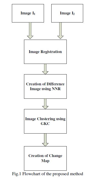 |
A. Creation of Difference Image |
| The proposed method of finding the difference image overcomes the effect of speckle noise. The difference image can be computed using normalized neighborhood ratio [15], represented byequation 1, |
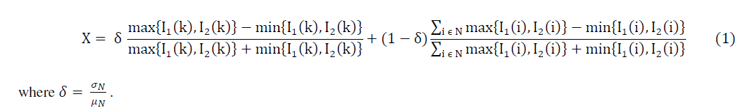 |
| The first term computes the normalized ratio of the pixel under consideration and the second term computes the sum of the normalized ratio of the pixels in the neighborhood N of the pixel under consideration. and are the variance and mean of the gray level in the neighborhood respectively. |
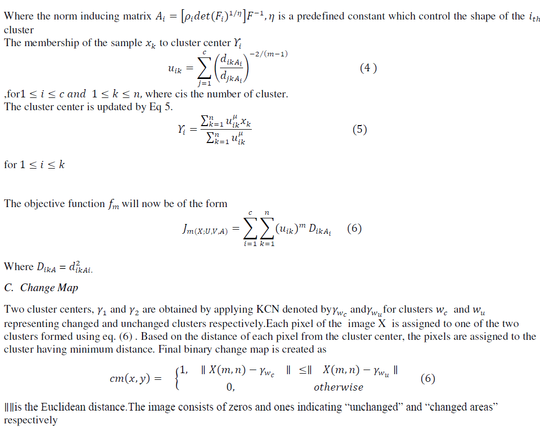
B. Clustering using Gustafsonkesselclustering(GKC) |
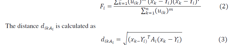
| Gustafson andkessel introduced adaptive distance norm to measure the distance between clusters using fuzzy covariance matrix. |
 |
 |
III. EXPERIMENTAL RESULTS AND DISCUSSIONS |
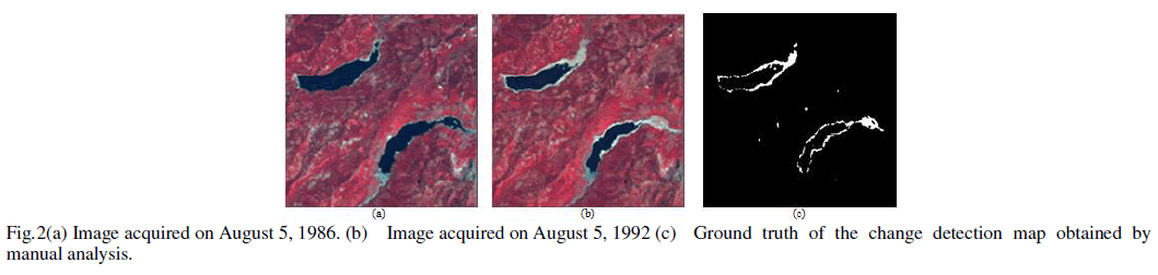
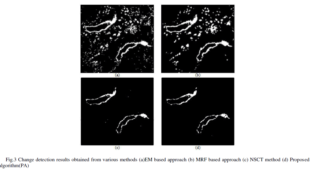
| The data set is taken from [16], the bitemporal images of partsof Reno–Lake Tahoe area acquired on August 5, 1986, and August 5, 1992 as shown in fig. 2 (a) and (b) is used for qualitative and quantitative in this paper.The algorithm was implemented in Matlab R2009a. Fig.2 (c) shows the ground truth of the change detection map obtained by manual analysis. The qualitative as well as quantitative comparison of the proposed algorithm was done with EM based approach [9], MRF based method [9] PNN based method [15] . |
 |
| For quantitative comparison ,the change detection mask obtained from each method and the ground truth image was used. Quantitative assessment of the proposed change detection method is done in following manner by using the criteria given in [17]. The following parameters were used: |
| First, calculate FN (False Negative), the number of changed pixels wrongly identified as unchanged pixels; second calculate FP (False Positive), the number of unchanged pixels identified as changed pixels. The overall error (OE) is the sum of FN and FP. Third, calculate TP (True Positive), the number of changed pixels correctly identified and TN (True Negative), the number of pixels correctly identified as unchanged for determining percentage correct classification (PCC) given by |
 |
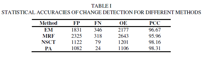
| The values of the abovementioned metrics for different methods are shown in table I. The results show that the proposed algorithm has highest overall accuracy, i.e., 98.31% and lowest omission error as compared to the other methods. It can be seen from fig. 3(a) and 3(b) that the results of EM and MRF based methods are quite unsatisfactory. They have low overall accuracy and high omission error. |
 |
 |
IV. CONCLUSION |
| An unsupervised method for change detection from remote sensing images using normalized neighborhood ratio and Gustafson Kesselclustering(GKC) is proposed. The algorithm initially computes the difference image using Normalized Neighborhood Ratio approach. Gustafson Kessel Clustering algorithm is used to create a change map by clustering the difference image into two clusters of changed and unchanged pixels. The algorithm was implemented using Matlab R2009a.The qualitative as well as quantative results of the proposed algorithm were compared with some of the existing methods. The algorithm finds the changes very accurately as compared to the other methods. |
References |
|