International Journal of Advanced Research in Electrical, Electronics and Instrumentation Engineering
ISSN ONLINE(2278-8875) PRINT (2320-3765)
ISSN ONLINE(2278-8875) PRINT (2320-3765)
N. Venkateswara Rao1 , T.Madhu2, Sk. Bibibathula3, P.Prathyusha4and Y. Anusha5
|
| Related article at Pubmed, Scholar Google |
Visit for more related articles at International Journal of Advanced Research in Electrical, Electronics and Instrumentation Engineering
Satellite-Based Augmentation Systems (SBAS‟s) are useful to aid the civil aviation in precision approach and other applications. India is developing its own navigation system, „GAGAN‟ (GPS Aided GEO Augmented Navigation), which is expected to become operational by 2014. A major concern that compromises accuracy in these systems is the fluctuating TEC at low latitudes which also displays steep horizontal gradients. The TEC values obtained from the SOPAC (Scripps Orbits and Permanent Array Center) data archive of the IGS (International GNSS (Global Navigation Satellite Systems) Service) for Bangalore Station(13.030N,77.510E),India show large variations, which can adversely affect the Indian GAGAN requirements. The TEC variations for quiet & storm days, their comparison with the IRI (International Reference Ionosphere) obtained over a period of one year (2003) give important features of the Indian low latitude region.
Keywords |
| GNSS, GPS, GAGAN, IRI, GEOMAGNETIC STORM, TEC |
INTRODUCTION |
| Around the world, several countries are developing Satellite Based Augmentation Systems (SBAS) to provide an accurate all-weather worldwide navigation capability. In India also, Indian Space Research Organization (ISRO) and Airport Authority of India (AAI) are jointly developing GPS Aided GEO Augmented Navigation System (GAGAN), and is expected to become operational by 2014[1-2]. |
| As the Indian subcontinent is spread over equatorial and low latitude regions, the ionospheric behavior is highly volatile with large horizontal gradients and day-to-day variability [3-4]. In addition to this, space weather disturbances such as solar flares, coronal holes and coronal mass ejections (CMEâÃâ¬ÃŸs) result in geomagnetic storms, which in turn influence the Total Electron Content (TEC) of the ionosphere[5-9]. High resolution applications of GPS technology will hence require better space weather support to compensate for this ionosphere – induced errors. |
| Accurate specification and prediction of ionospheric conditions for both quiet and disturbed periods will aid in the design and operation of Global Navigation Satellite Systems (GNSS). Hence, the primary task in developing an ionospheric model for GAGAN will be to develop a suitable TEC model for the Indian subcontinent and take TEC measurements at fixed reference stations using dual frequency GPS Receivers and combine them in real time to estimate the current state of the ionosphere. As part of the objective, the TEC values obtained using the SOPAC data archive[10] of the International GNSS Service (IGS) for a low latitude station, Bangalore Station (13.030N, 77.510E) in India during the year 2003 are analyzed. The obtained TEC values are also compared with the TEC values obtained from International Reference Ionosphere 2007 (IRI) empirical model [11]. |
| The Ionospheric time delay is a function of the total electron content (TEC) along the signal path and the frequency of the propagated signals. The TEC of the ionosphere, which is an integral of the electron density in a column of 1 m2 from the observation point to the satellite, is given by |
 |
| Where, Re is radius of earth (6378 Km),θ is the elevation angle and hi is the height of the ionosphere shell (350 Km). TEC can also be easily converted to ionospheric range delay for the L1 and L2 frequencies. One TECU is equal to 0.16 meters range delay on L1 frequency and 0.27 meters on L2 frequency [12]. |
III. RESULTS AND DISCUSSION |
| In this paper, the daily minute wise TEC values are obtained for a low latitude station, Bangalore Station (13.030N,77.510E), India during the year 2003 using the SOPAC data archive of the International GNSS Service (IGS). Then the minute wise TEC values are averaged over an hour on each day. |
A. Diurnal variations of TEC in the year 2003 |
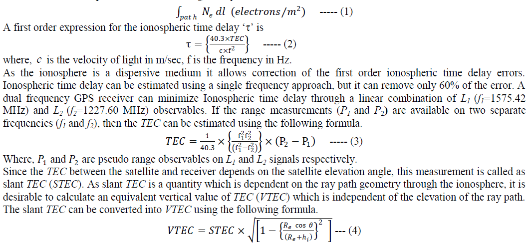
| The calendar year 2003 is divided into four seasons depending on the ionospheric conditions. They are winter (Jan-Feb & Nov-Dec), Vernal Equinox (Mar-Apr), Summer (May-Aug) and Autumn equinox (Sept-Oct). From each season only one month has been considered as an example to show the daily TEC variations and is presented in Fig.1. The daily TEC variations for all the days within a particular month are grouped together and plotted in each sub plot. |
 |
| From Fig.1 (a), it is evident that, in the month of February, 2003 (Winter season), the daily maximum TEC is around 75 TECU for most of the days in the noon hours. From Fig.1 (b), in the month of March, 2003 (Vernal equinox season), the daily maximum TEC is around 75 TECU for most of the days. The maximum TEC occurrence time is around 20:00 hr LT in this season. From Fig.1 (c), it is evident that for most of the days in the month of July, 2003 (Summer season), the daily maximum TEC is less than 100 TECU. The maximum TEC occurrence time is around 13:00 hr LT in this season. From Fig.1 (d), it is evident that for most of the days in the month of October, 2003 (Autumn equinox season), the daily maximum TEC is around 70 TECU and maintains at the same throughout the day time. From the results, it is evident that the TEC exhibits an appreciable day to day variability irrespective of the month or season. |
B. Monthly variations of TEC in the year 2003 |
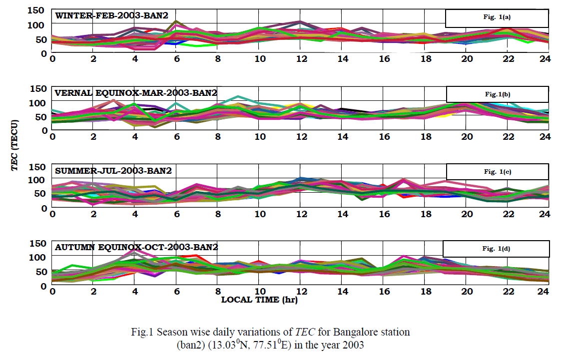
| The month wise (January to December) daily variations of VTEC and their comparison with the IRI- 07 predicted monthly mean TEC values are presented as subplots in Fig.2. It is observed that the difference between the maximum TEC on each day and the monthly mean maximum TEC is around 15 to 20 TECU. From the plots, it is also clearly evident that the TEC obtained from GPS data exhibits monthly variation, whereas the TEC obtained from IRI 07 empirical model is almost consistent for all the months in the year 2003. |
 |
C. Variations of TEC during October 2003 Halloween storm |
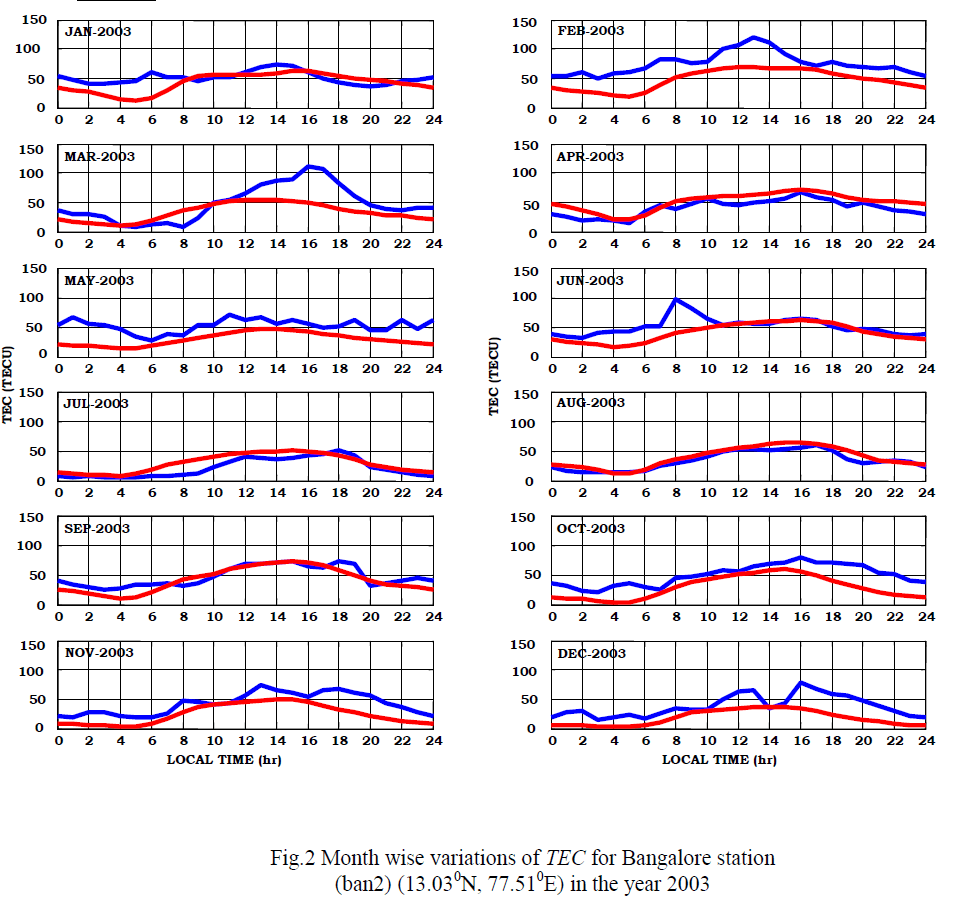
| Extreme solar flares can cause extreme variations in ionospheric parameters. A number of major solar flares and Coronal Mass Ejection (CME) events occurred from 28th October to 31st October, 2003 have resulted in an extreme geomagnetic storm. The CMEâÃâ¬ÃŸs take around 20 hours to travel from sun to reach earth.The world over, severe enhancements in the TEC occur due to the magnetic storms on Sun and cause distortion to the GNS systems. |
| The magnetic conditions were extremely disturbed throughout the entire period under consideration. An extreme geomagnetic storm commenced on 30 October 2003 with Two Dst peak values on this day. The first peak Dst value of -353 nT has occurred at 01:00 UT and the second peak Dst value of -383 nT at 23:00 UT[13]. The Kp index of this storm is 9[14]. The SSN on that day is 167. From the Dst and Kp indices, it is evident that the October 2003 storm is very severe and is considered as the 6 th most severe geomagnetic storm since 1932 and is called as „Halloween stormâÃâ¬ÃŸ. |
| The variations in TEC during the October 2003 storm period are presented in Fig.3. From the figure, it is evident that the TEC has a large day to day variability during storm days i.e. from 27th October to 01st November 2003. On 27th October the maximum TEC value of 100.2 TECU is observed at 07.00 LT .On 28th and 29th October the maximum TEC values are 88 TECU and 148 TECU respectively observed at 17.00 LT. On 30th October the maximum TEC value is around 74 TECU at 17.00 LT. On 31st October the maximum TEC value is around 85 TECU at 20.00 LT. The results are also compared with IRI-07 model results. From IRI-07 results, it is evident that, on any storm day the maximum TEC value is around 55 TECU only. More over IRI-07 model predicted maximum TEC value occurrence time is around 15.00 LT on all the storm days. IRI estimates are almost consistent over the storm period and the IRI estimates did not catch-up with any of the variability taking place in the ionosphere. However, it is observed that the IRI is providing a reasonable estimate of TEC in comparison with the measured values from midnight to morning 06.00 LT on any day. |
 |
| The accuracy requirement of the ionospheric model for GAGAN is better than 3 TEC units (corresponding to a delay of 0.5m). This clearly demonstrates the necessity of developing a region specific ionospheric model for the Indian conditions, by analyzing GPS data from more number of locations, so as to obtain a more accurate prediction. |
IV. CONCLUSIONS |
| The diurnal, monthly and storm time variations of TEC during the year 2003 for the low latitude station Bangalore Station(13.030N,77.510E), India give important features, which ultimately affect the performance of the GNSS systems. The TEC values obtained based on GPS data are also compared with the TEC values obtained from IRI-07 model. It is observed that the IRI is not able to predict the TEC variations for the Indian conditions. The results reported in this paper can be useful for developing/ modifying the proposed algorithms for GPS applications in India and for predicting the ionospheric variability in multiple directions around the reference or user stations and for estimating the reliability of the GAGAN system. |
V. ACKNOWLEDGEMENTS |
| The data used in this analysis is obtained from SOPAC data archives of the IGS network. |
References |
|