Research & Reviews: Journal of Ecology and Environmental Sciences
ISSN: 2347-7830
ISSN: 2347-7830
Freelance Writer, Food and Environment Issues, Bikaner, Rajasthan, India
Received Date: 09/02/2018; Accepted Date: 20/03/2018; Published Date: 26/03/2018
Visit for more related articles at Research & Reviews: Journal of Ecology and Environmental Sciences
Not only the modern conventional resource extractive professions like mining but also the conventionally or inefficiently run traditional professions like agriculture might give rise to excessive bare soil conditions, leading to soil degradation or soil fertility reduction and posing a serious threat to environment. Nowadays term sustainable conservation agriculture is much more in use particularly in India where cropland on around 55% land exists while the world average is 12.5% only. Further, the issue of realistic approach versus academic interests has been perhaps dominant in deciding degraded lands estimation methodology to practically reclaim, ameliorate and manage resources for sustainable conservation agriculture in India. In this context, in this paper, an attempt is made to express the academic concerns regarding land use aspects on the basis of derivation of Bare Soil Risk Cover - Ground Cover regression line equations, also called forestation lines, from Bare Soil Area - Bare Subfactor relationship with view point of canopy covering of soil for environment protection.
Bare soil area, Ground cover, Soil erosion, Environment, Agriculture
Traditionally India has been known for evergreen forests and pastures as well as hermits (couples like Anasuya-Atri, Arundhati-Vasishtha, Renuka-Jamdagni), foresters and animal-keepers dedicated to maintenance of green cover and biodiversity on land along with its reasonable utilization by them and their kept animals and entire biosphere. Agriculture is also regarded as a traditional profession which deals with crops or vegetation that are timely harvested leading to somewhat bare soil conditions. The conventional form of agriculture, like other conventional professions say mining is resource extractive. In environmental context the bare soil consequences are seen as soil loss, soil fertility reduction, earthquake intensity and frequency increase, landslides and climate change (or global warming). India is often called an agricultural country on account of its large cropland, around 55 percent of total country landscape (USGS around Report, 2017: conversion data, India ranks first with 179.8 million hectares cropland area). On the other hand the forest cover is regarded as 21.34 percent of total India’s area [1].
However globally forests cover around 30 percent of the Earth’s surface and world average of cropland is 12.5 percent (USGS Report, for percentage, conversion data: 1.87 billion hectares of cropland in the world) [2,3]. It means Indian forest cover percentage is almost two-third of global average, while Indian cropland data is almost 4.5 times of world average. Question arises whether Indian agriculture is running currently in the state of excessive soil erosion as a consequence of bare soil condition. If yes, how environmental land use aspects are important in Indian context. In this paper an attempt is made to focus on academic concerns regarding land use when realistic approach is nowadays dominant in estimating land degradation in India. With the help of Bare Soil Sub factor Bare Soil Area relationship, some points on the curve are identified and corresponding Soil Loss Risk Cover and Ground Cover data are calculated [4]. Then linear regression relationships between consecutive points, also called forestation lines, are established to have an idea of nature’s support in human attempts of forestation to discuss environmental use aspects in Indian contexts.
Estimation of Degraded Lands in India: Realistic Versus Academic Issue
The harmonization process methodology for estimation of degraded and wasteland, in India, focuses on the practicality viewpoints. It ascertains exclusion parameters like pH of soil greater than 5.5 (not 7.0), forest canopy greater than 40 (not 70) percent, and soil erosion rate lesser than 10 (not decimals, 1,2,3,4 or 5) tons per hectare per year while declaring degraded and wastelands. The policy matter in deciding soil degradation clearly deals with practicalities avoiding academic interests- “The harmonized estimates have been derived from the point of view of the practicalities of the reclamation, amelioration and management for agricultural planning rather than purely academic interest” [5]. It means there is a much gap between exclusion data, particularly soil erosion, while declaring degraded and wastelands in India. It is all perhaps for making conservation agriculture sustainable, as stated in ICAR report. Nowadays the term ‘sustainable conservation agriculture’ is much more in use in India where 55 percent land is under farming while global average for cropland is 12.5 percent only. The question arises how practicality (or realism) versus academics issue might be dominant with differences in land use patterns. Perhaps land use modifications are more important as policy matter for degraded land estimation rather than compromises with land misuse borne situations. It is perhaps essential to know what truly the practicalities linked with sustainable conservation agriculture are, due to which India does not consider its land with soil erosion less than 10 tons per hectare per year under water erosion (or soil loss) and wind erosion classes even if erosion exceeds 5 tons per hectare per year.
Practicalities of Indian Sustainable Conservation Agriculture
One of the major hard core practicalities, perhaps (not sure; assumption of the author of this paper), is the fact that average soil erosion rate of the Asian country Japan is as high as 10.5 tons per hectare per year (JARQ). Japan claims land use around 68 per cent for dense forest and pasture (highest among developed and developing countries), and cropland around 12 per cent, near to global average [6]. In fact this erosion rate should not be made basis of deciding exclusion parameter for soil erosion at the time of estimating degraded and wastelands. Japan is an archipelago situated on young tectonic plates and therefore is frequently affected of intense earthquakes and sometimes of violent tsunamis. The maintenance of average erosion rate 10.5 tonnes per hectare per year for Japan is the outcome of continuous human efforts of dense bio-diverse forestation. India might choose exclusion parameter for erosion rate, while deciding degraded and wastelands, perhaps far below 5 tons per hectare/year if not in decimals. In this way India can consider larger land for planning and action to afforest and use the land resource properly. Land misuse is the real problem, giving rise to hardcore practicality in establishing exclusion parameter for soil erosion rate 10 tons per hectare per year at the time of degraded and wastelands estimation. Today’s rural Indian lifestyle is strongly linked with farm lands and urban people live in horizontally expanded housing colonies. India requires at least 33.33% of its landscape under dense forest with greater than 60% canopy cover to make healthy environment for people and entire biosphere.
The last, but not the least, hardcore practicality of Indian sustainable conservation agriculture is the mental inertia of planners that the situations can’t change. Anyhow if land acquirement is legally done in favor of forests and pastures, the situations can change. However updating of forest maintaining and animal-keeping professions in the form of modern industry (forestry and dairy industry) and advanced product marketing is almost essential whenever the situations change in the favor of forests and pastures.
Academic Concerns of Environmental Land Use Aspects
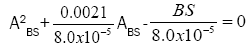
Soil erosion by water is a natural process that either cannot be avoided or can be avoided by means of almost 100 per cent ground cover [4]. It is the important deduction from Bare Soil Area (ABS) in percent and Bare Soil Subfactor (BS) relationship established by Bagarello and Ferro [4].
BS=8.0 × 10⁻⁵ A2BS + 0.0021 ABS (1)
The Bare Soil Subfactor (BS), the index of soil loss due to water or rainfall indicates how much soil loss risk is present and varies between 0 (minima) and 1 (maxima), if negative values of ABS are avoided. The quadratic equation can also be written down as follows:
 (2)
(2)

The equation (2) leads to two roots for Bare Soil Area-
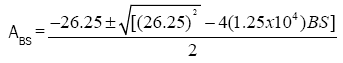
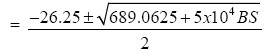 (3)
(3)
After avoiding negative sign of square root, the corresponding important (BS, ABS) points can be derived from equation (3) (Table 1). Two terms can also be introduced as follows:
Table 1. Bare soil subfactor, bar soil area, soil loss risk cover and ground cover data and linear regressions.
| S.No | Bare Soil Subfactor (BS) | Bare Soil Area (ABS) % | Soil Loss Risk Cover % RCSL=100(1-BS) | Ground Cover % GC=100-ABS | RCSL-GC Linear Regressions y-y1,= (x-x1)(y2-y1)/(x2-x1) |
|---|---|---|---|---|---|
| 1 | 0 | 0 | 100 (100% or total risk cover) | 100 (100% or complete landscape covered) | |
| 2 | 0.1 | 24.59 (around 25%) | 90 | 75 | RCSL=0.4GC+60 |
| 3 | 0.2 | 38.57 (around 39%) | 80 | 61 | RCSL=0.714GC+ 36.446 |
| 4 | 0.3 | 49.38 (around 50%) | 70 (70% risk cover) | 50 (50% landscape covered) | RCSL=0.91GC+ 24.50 |
| 5 | 0.4 | 58.79 (around 59%) | 60 | 41 | RCSL=1.111GC+ 14.45 |
| 6 | 0.5 | 67.01 (around 67%) | 50 (50% risk cover) | 33 (one-third landscape covered) | RCSL=1.25GC+ 8.75 |
| 7 | 0.6 | 74.47 (around 75%) | 40 (40% risk cover) | 25 (one-third landscape covered) | RCSL=1.25GC+ 8.75 |
| 8 | 0.7 | 81.33 (around 81%) | 30 | 19 | RCSL=1.667GC-1.673 |
| 9 | 0.8 | 87.73 (around 88%) | 20 | 12 | c |
| 10 | 0.9 | 93.75 (around 94%) | 10 | 6 | RCSL=1.667GC |
| 11 | 1.0 | 99.45 (around 100%) | 0 (Total soil loss no risk cover) | 0 (Total bare landscape) | RCSL=1.667GC |
Percent Ground Cover=100 - ABS;
Percent Soil Loss Risk Cover = 100 (1 - BS)
The academic concerns of environmental land use aspects, studied using Bagarello and Ferro relationship between Bare Soil Subfacter (BS) and Bare Soil Area (ABS), are presented as follows:
• 100% risk cover from soil loss is possible if 100% (complete) landscape is covered by vegetation (Table 1).
• 50% ground cover is capable of covering 70% soil loss risk (Table 1).
• One-third landscape cover covers 50% soil loss risk (Table 1).
• One-fourth coverage of landscape leads to coverage of 40% soil loss risk (Table 1).
• Total bare landscape with no vegetative cover is on 100% risk of soil loss (Table 1).
• The regression lines could be regarded as forestation lines. The lines between the points (0%, 0%) and (10%, 6%), (10%, 6%) and (20%, 12%) (20%, 12%) and (30%, 19%) and (30%, 19%) and (40%, 25%) for parameters RCSL and GC show zero or negative intercepts. The intercept on RCSL axis perhaps indicates how nature helps the human efforts of forestation with view point of soil loss risk cover. That would probably mean that a country should at least keep one-fourth of its landscape under dense bio-diverse forest cover for natural help in soil conservation.
• The regression line between the (RCSL, GC) points (40%, 25%) and (50%, 33%) is RCSL=1.25GC+8.75. And the same regression line is observed between the points (50%, 33%) and (60%, 41%). It would probably mean that the nature would be equally helpful is afforesting one-third and 40% landscapes.
• The intercept of RCSL-axis increases gradually from 40% to 100% ground cover conditions. It would probably mean that nature considerably helps a forestation from GC 40% onwards. The reducing slopes in forestation lines marching towards high GC perhaps indicate that lesser human efforts are required in dense to denser forestation.
The geological land conditions differ from place to place and academic concerns of land use aspects are therefore not universally applied. Indian forests are nowadays mostly scattered and agricultural land too remain mostly bare in post-harvest and pre-sowing periods. Infrastructure and built up lands too are not well compact. In such a situation Indian ground cover could be considered as below 30% corresponding to less than 50% coverage of soil loss risk. But geological land condition of Japan is different. Due to being situated on tectonic plates this archipelago has to keep 68% of its land surface under dense forest- pasture cover to get 50% soil loss risk cover. It is worth mentioning that average soil loss rate of Japan is 10.5 tons per hectare per year almost two-third of that of India India’s average soil loss rate in 2010 was estimated 16.4 tons per hectare per year [7]. India can easily attain the 60 percent GC (ground cover) condition by densification of its one-fifth land area claimed as forest and conversion of non-productive land under agriculture, one fourth of total land area, to evergreen pastures. In this way around 75 per cent soil loss risk might be covered in India. If urban infrastructure is compactly created, the soil loss risk might perhaps be covered up to 90 percent leading to considerably reduced soil loss risk perhaps at the rate around 1 ton per hectare per year. Of course updating of forestry and animal-keeping professions seems essential for proper land usage. The experimental attempts, made in Burundi (Africa), to determine values of cover and crop management factor of the USLE (Universal Soil Loss Equation) confirm that forest and grass covers are more competent than cultivated cover with the view point of soil conservation [8]. As far as cultivated cover values are concerned, these largely depend on cropping system during rotation. In an experiment, conducted in Italy, it was found that competence of cropping system during rotation in descending order is as follows- Oat/lupin/ cauliflower- potato (conventional tillage)> Cauliflower-potato/oat/lupin (strip tillage for cauliflower and potato and conventional tillage for others)> Natural vegetation/rye/lupin (minimum tillage)> Lupin/tall fescu (minimum tillage) [9]. The soil conservation facilitates Crop yield and food cost control. The scarcely conserved Indian soil demands land reforms: forest and pasture densification and extension [10,11].
The Bagarello bare soil area - subfactor relation gives an idea, how much a bare soil area qualitatively presents threat to the environment. In this paper an attempt is made to convert it in forestation linear equations (Groundcover-Soil Loss Risk Cover relations) to infer how forestation covers the soil loss risk. India can easily attain the 60 percent groundcover condition by land reforms and can cover 75 percent soil loss risk with updating of forestry and animal-keeping professions.